
Pacific north coast integrated management area plan
Table of Contents
- Preface
- Executive Summary
- List of Acronyms and Initialisms
- Acknowledgements
- 1.0 Plan Context
- 2.0 The Planning Area
- 3.0 The Planning Process
- 4.0 Ecosystem-Based Management Framework
- 5.0 Implementation
- References
- Glossary of Terms
- Appendix 1 Federal and Provincial Legislative and Regulatory Summary Tables
- Appendix 2 PNCIMA Supporting Documents
- Appendix 3 Marine Activity Profiles and Future Outlook
- Appendix 4 Maps
- Appendix 5 Committees and Participants
- Appendix 6 Record of Meetings
- Appendix 7 Valued Ecosystem and Socio-economic Components
- Figure 2-1 Pacific North Coast Integrated Management Area (PNCIMA)
- Figure 3-1 PNCIMA Process Structure
- Figure 3-2 Options for Participating in the PNCIMA Process
- Figure 3-3 PNCIMA Timeline
- Figure 4-1 Components of the PNCIMA Ecosystem-Based Management (EBM) Framework
- Figure A7-1 Process for Identifying Valued Ecosystem Components
- Figure A7-2 Realms of the Socio-economic System
- Table 2-1 Communities in the Coastal Watersheds in PNCIMA
- Table 4-1 Goals, Objectives and Strategies for PNCIMA
- Table A1-1 Federal Agencies with Direct Roles in Ocean Management in PNCIMA
- Table A1-2 British Columbia Agencies with Direct Roles in Ocean Management in PNCIMA
- Table A3-1 Summary of Marine Activity Profiles and Future Outlook
Appendices
List of figures
List of tables
Dear reader,
On behalf of the Pacific North Coast Integrated Management Area (PNCIMA) Steering Committee, we are pleased to present the Integrated Ocean Management Plan for the Pacific North Coast area.
This document provides high-level direction on the planning and management of marine activities and resources in the area, and has been developed with extensive input from a broad range of partners, including First Nations, provincial and federal governments, industry, non-governmental organizations, academia and local community residents.
We would like to thank the many individuals and partners who collaborated in the development of this plan. Their experience and perspectives have proven invaluable in creating a comprehensive, strategic framework to support a more holistic and integrated approach to ocean use in PNCIMA.
Ongoing participation, support and commitment from partners and stakeholders in implementing this plan will help ensure that healthy and functioning ecosystems and coastal communities are maintained in this significant and unique marine area.
Sincerely,

Dominic LeBlanc
Minister
Fisheries and Oceans Canada

Steve Thomson
Minister
BC Ministry of Forests, Lands, & Natural Resource Operations

Marilyn Slett
President
Coastal First Nations – Great Bear Initiative
- As directed by:
- Council of the Haida Nation (also representing Old Massett Village Council and Skidegate Band Council)
- Gitga’at Nation
- Heiltsuk Nation
- Kitasoo/Xai’Xais Nation
- Metlakatla First Nation
- Nuxalk Nation
- Wuikinuxv Nation

Robert Grodecki
Executive Director
North Coast-Skeena First Nations Stewardship Society
- Gitxaala First Nation
- Metlakatla First Nation
- Kitsumkalum First Nation
- Kitselas First Nation
This plan is not legally binding and does not create legally enforceable rights between Canada, British Columbia or First Nations. This plan is not a treaty or land claims agreement within the meaning of sections 25 and 35 of Canada’s Constitution Act, 1982.
This plan does not create, define, evidence, amend, recognize, affirm or deny any Aboriginal rights, Aboriginal title and/or treaty rights or Crown title and rights, and is not evidence of the nature, scope or extent of any Aboriginal rights, Aboriginal title and/or treaty rights or Crown title and rights.
This plan does not limit or prejudice the positions Canada, British Columbia or First Nations may take in any negotiations or legal or administrative proceedings.
Nothing in this plan constitutes an admission of fact or liability.
Nothing in this plan alters, defines, fetters or limits or shall be deemed to alter, define, fetter or limit the jurisdiction, authority, obligations or responsibilities of Canada, British Columbia or First Nations.
Executive Summary
The Pacific North Coast Integrated Management Area (PNCIMA) is one of five national Large Ocean Management Areas identified in Canada’s 2005 Oceans Action Plan. The PNCIMA plan is the product of a collaborative process led through an oceans governance agreement between the federal, provincial and First Nations governments, and contributed to by a diverse group of organizations, stakeholders and interested parties. The plan is high level and strategic, and provides direction on and commitment to integrated, ecosystem-based and adaptive management of marine activities and resources in the planning area as opposed to detailed operational direction for management.
The plan outlines a framework for ecosystembased management (EBM) for PNCIMA that includes assumptions, principles, goals, objectives and strategies. This EBM framework has been developed to be broadly applicable to managers, decision-makers, regulators, community members and resource users alike, as federal, provincial and First Nations governments, along with stakeholders, move together towards a more holistic and integrated approach to ocean use in the planning area.
PNCIMA’s EBM goals are interconnected and cannot be taken as separate from one another. The purpose of the PNCIMA EBM framework is to achieve:
- integrity of the marine ecosystems in PNCIMA, primarily with respect to their structure, function and resilience
- human well-being supported through societal, economic, spiritual and cultural connections to marine ecosystems in PNCIMA
- collaborative, effective, transparent and integrated governance, management and public engagement
- improved understanding of complex marine ecosystems and changing marine environments
The plan also provides an information base and a number of management tools that can be used by other parties to facilitate the application of EBM at a variety of scales in PNCIMA.
Five priorities are identified for short-term implementation of the plan:
- governance arrangements for implementation
- marine protected area network planning
- monitoring and adaptive management
- integrated economic opportunities
- tools to support plan implementation
Implementation is the shared responsibility of all signatories to the planning process and will be undertaken within existing programs and resources, where possible.
To address plan performance monitoring and evaluation, indicators will be developed to monitor and evaluate plan outcomes, and comprehensive reviews will be undertaken to assess progress in achieving the EBM goals and objectives. Findings from the performance evaluation, along with emerging management needs and priorities, will be considered and, where appropriate, incorporated into implementation so that the plan reflects changing circumstances and conditions as they arise.
The PNCIMA data collection phase occurred between 2007-2012. The data, statistics and trends referenced in the document reflect the best information available during that timeframe.
List of Acronyms and Initialisms
The following acronyms and initialisms are used in the context of integrated oceans management for PNCIMA:
- B.C.
- British Columbia
- DFO
- Fisheries and Oceans Canada
- EBM
- Ecosystem-based management
- EBSA
- Ecologically and Biologically Significant Area
- IOAC
- Integrated Oceans Advisory Committee
- LOMA
- Large Ocean Management Area
- MaPP
- Marine Plan Partnership for the North Pacific Coast
- MOU
- Memorandum of Understanding
- MPA
- Marine protected area
- PNCIMA
- Pacific North Coast Integrated Management Area
Acknowledgements
The Pacific North Coast Integrated Management Area (PNCIMA) plan represents the culmination of several years of dedicated work by dozens of people who represent marine sector interests as well as First Nations, provincial and federal governments.
The governance partners of the PNCIMA initiative, including Fisheries and Oceans Canada, the Province of British Columbia, the Coastal First Nations, and the North Coast-Skeena First Nations Stewardship Society would like to recognize and thank the following individuals who played key roles in providing technical support, direction and oversight on the production of this document:
- Aaron Heidt
- Alex Chartrand
- Allan Lidstone
- Amy Wakelin
- Andrew Johnson
- Andrew Mayer
- Angela Stadel
- Averil Lamont
- Barry Smith
- Blair Hammond
- Bonnie Antcliffe
- Brenda Gaertner
- Bruce Reid
- Bruce Watkinson
- Candace Newman
- Caroline Butler
- Caroline Wells
- Catherine Rigg
- Celine Menard
- Charles Hansen
- Charlie Short
- Chris McDougall
- Chris Picard
- Chris Wilson
- Christie Chute
- Coral Keehn
- Craig Outhet
- Cristina Soto
- Dale Gueret
- Danielle Shaw
- David Leask
- Dayna Leganchuk
- Denise Zinn
- Diana Freethy
- Doug Neasloss
- Erin Mutrie
- Evan Putterill
- G. Les Clayton
- Garry Wouters
- Gary Alexcee
- Gary Wilson
- Glen Rasmussen
- Gordon McGee
- Graham van der Slagt
- Greg Savard
- Harry Nyce Sr.
- Hilary Ibey
- Hilary Thorpe
- James Boutillier
- Jas Aulakh
- Jason Thompson
- John Bones
- Joy Hillier
- Julie Carpenter
- Karen Topelko
- Kate Ladell
- Keeva Keele
- Kelly Francis
- Ken Cripps
- Kendall Woo
- Kevin Conley
- Kyle Clifton
- Lara Sloan
- Larry Greba
- Leri Davies
- Marc-Andre deLauniere
- Masoud Jahani
- Matthew Justice
- Maya Paul
- Megan Mach
- Mel Kotyk
- Miriam O
- Neil Davis
- Nicholas Irving
- Nicole Gregory
- Peter Johnson
- Rebecca Martone
- Rebecca Reid
- Rob Nelles
- Robert Grodecki
- Ross Wilson
- Russ Jones
- Sean MacConnachie
- Sheila Creighton
- Siegi Kriegl
- Sophie Tee
- Spencer Siwalace
- Steve Diggon
- Tanya Punjabi
- Terrie Dionne
- Terry Collins
- Terri-Lynn Williams-Davidson
- Trevor Russ
- Verne Jackson
- Wally Webber
- Whitney Lukuku
- Whitney Sadowsky
- Wilfred Dawson
The PNCIMA initiative governance partners would also like to recognize the following individuals who provided guidance to the planning process and its outputs through their involvement in the Integrated Oceans Advisory Committee:
- Al Huddlestan
- Alan Thomson
- Andrew Webber
- Arnie Nagy
- Bill Johnson
- Bill Wareham
- Bob Corless
- Brad Setso
- Brian Lande
- Bruce Watkinson
- Christa Seaman
- Christina Burridge
- Craig Darling (Facilitator)
- Dan Edwards
- David Minato
- Des Nobels
- Doug Aberly
- Evan Loveless
- Heidi Soltau
- Jeremy Maynard
- Jessica McIlroy
- Jim Abram
- Jim McIssac
- John MacDonald
- Kaity Stein
- Ken MacDonald
- Kim Johnson
- Kim Wright
- Lorena Hamer
- Matt Burns
- Maya Paul
- Nick Heath
- Patrick Marshall
- Phillip Nelson
- Richard Opala
- Roberta Stevenson
- Ross Cameron
- Rupert Gale
- Stephen Brown
- Urs Thomas
The PNCIMA initiative also acknowledges the work of Tracey Hooper for her services in editing this document.
The PNCIMA plan was designed by Ion Brand Design, and printed by Hemlock Printers Ltd. Haida artwork included in this plan was created by Tyson Brown. Front and back cover photos by Iain Reid.
1.0 Plan Context
The Pacific North Coast Integrated Management Area (PNCIMA) is one of five national Large Ocean Management Areas (LOMAs) identified in Canada’s 2005 Oceans Action Plan. The PNCIMA plan is the product of a collaborative process led through an oceans governance agreement between federal, provincial and First Nations Footnote 1 governments and contributed to by a diverse range of organizations, stakeholders and interested parties. The plan is strategic in nature and has been developed pursuant to the 2008 Collaborative Governance Memorandum of Understanding (MOU) among Canada, the Province and First Nations.
1.1 Global Context
In the last century, the ocean has been a new frontier for food sources, transportation, recreation, minerals, energy resources and biotechnology. This trend is expected to continue: growing human populations translate to advances in technology, international movement of products, coastal development and recreation, food production and energy from oceans.
However, development has had its costs. The health of oceans throughout the world is declining along with their ability to produce food, protect against storms, process waste and provide other services that are critical to humans and other life forms (Pew Oceans Commission 2003; U.S. Commission on Ocean Policy 2004; Ban and Alder 2007; Ban et al. 2010).
Three main drivers are believed to affect marine sustainability:
- direct impact of human values and resulting activities in ocean and coastal areas (e.g., unsustainable resource extraction, pollution, urban development and incompatible and crowded ocean uses);
- climate-related impacts (e.g., changing ocean chemistry, temperature and sea levels); and
- limitations of many existing management systems (e.g., divided and duplicated jurisdictions and laws, single sector approaches, limited knowledge, and gaps in responsibility for cumulative effects and overall ocean health) (PNCIMA 2010).
The combination of an increase in ocean use and a decline in ocean health has led to greater interest in sustainable ocean management. Planning for more integrated management of oceans is a pragmatic approach to address these challenges and support opportunities presented by collaboration among ocean users.
Integrated management involves the comprehensive planning and managing of human activities to minimize conflict among users; a collaborative approach that cannot be forced on anyone; and a flexible and transparent planning process that respects existing divisions of constitutional and departmental authority and does not abrogate or derogate from any existing Aboriginal rights or treaty rights (DFO 2002b). Benefits of integrated management planning include:
- reducing cumulative effects of human uses on marine and coastal environments;
- providing increased certainty for the public and private sector regarding existing and new investments; and
- reducing conflict between uses (Minister of Public Works and Government Services 2005).
Additional benefits include:
- integration of data collection and synthesis, monitoring, research, information sharing, communication and education;
- development of inclusive and collaborative oceans governance structures and processes;
- application of flexible and adaptive management techniques to deal with uncertainty and improvements in the understanding of marine species and ecosystems; and
- planning on the basis of natural and economic systems together rather than principally on political or administrative boundaries (DFO 2002b).
Integrated management planning is being implemented at multiple scales by countries and coastal areas in Europe, Australia, Asia and North America. It is informed by international, national and coastal scale processes and sector-based planning initiatives that direct the management of activities.
An important principle that guides integrated management planning is the need to identify ecosystem-based management (EBM) objectives and reference levels to guide the development and implementation of management to achieve sustainable development (DFO 2002b).
1.2 PNCIMA Context
The health of oceans throughout the world is declining along with their ability to produce food, protect against storms, process waste and provide other services that are critical to humans and other life forms.
As in other parts of the world, the PNCIMA ocean environment faces challenges. These challenges, as well as important opportunities, have been identified as driving the need for an integrated management plan in PNCIMA (J.G. Bones Consulting 2009).
Humans have lived in this area for thousands of years, sustained by its abundant marine and terrestrial resources, which also shaped the inhabitants’ social, economic and cultural values. Presently, PNCIMA is home to diverse First Nations, coastal settlements and major communities. The inshore waters of PNCIMA support fishing, aquaculture, marine tourism and transportation. The offshore areas support numerous commercial fisheries and transportation, and the potential for energy developments. The region’s ports are conduits of trade linking Canada‘s businesses to markets in North America, Asia and Europe. The area is ecologically unique for the diversity of ocean features it contains and the important habitat it provides for many species. Increased use of the area exerts increased pressure on ecosystems; therefore, it is important to ensure the coexistence of healthy, fully functioning ecosystems and human communities.
The Great Bear Rainforest (Central and North Coast) and Haida Gwaii are both immediately adjacent and inextricably linked to PNCIMA through collaborative efforts among the federal, provincial and First Nations governments to institute terrestrial ecosystem-based management. These efforts, which have taken place over the past 20 years, have resulted in economic and ecological benefits.
The management and regulation of ocean use in PNCIMA involves a number of First Nations, federal and provincial government departments, local governments and organizations with linked, parallel or overlapping roles and responsibilities that require coordination and harmonization. A summary of federal and provincial legislation and regulations relevant to PNCIMA is provided in Appendix 1. In addition, First Nations have laws, customs and traditions relevant to PNCIMA.
1.3 Plan Scope
The PNCIMA initiative’s aim is to engage all interested and affected parties in the collaborative development and implementation of an integrated management plan to ensure a healthy, safe and prosperous ocean area.
The plan is high level and strategic, and provides direction on and commitment to integrated, ecosystem-based and adaptive management of marine activities and resources in the planning area. Work plans will be developed to support implementation of the plan. The plan focuses on the overall management of PNCIMA by considering ocean uses and the environment. This enables marine planning, management and decision-making to occur at appropriate spatial scales from regional to site-specific. It also promotes the consideration of the interactions among human activities, and between human activities and the ecosystem (DFO 2007a).
The plan presents an ecosystem-based management framework that provides context and direction for ocean management. It contains a set of long-term, overarching goals for ecological integrity, human well-being, collaboration, integrated governance, and improved understanding of the area. These goals are supported by more specific objectives that express desired outcomes and conditions for PNCIMA. The goals and objectives provide the basis for defining management strategies and measuring progress on plan implementation. Above all, the ecosystem-based management framework seeks to ensure that relationships between ecosystem and human use objectives are recognized and reflected in future management decisions.
Together, PNCIMA’s EBM framework, information base (Appendix 2) and decision support tools contribute to the foundation for integrated oceans management in the area, and will support and enable integrated management within other planning, regulatory, decision-making and stewardship processes.
The plan is not intended to provide a detailed prescription of all measures required to achieve its objectives. Instead, it aims to enhance and support existing decision-making processes by linking sector planning and management to an overarching EBM framework. The plan also identifies priorities for action that flow from the EBM framework.
Implementation of the plan is expected to result in greater certainty and stability in oceans management; better integration and coordination of new and existing management and planning processes; sustainable management of resources; and contributions to a national network of marine protected areas (MPAs). However, the plan does not establish a new regulatory framework, restrict existing legislative authorities, fetter ministerial discretion, or fetter or restrict authorities or decisions of the First Nations. Implementation of the plan will take place within existing programs and resources, where possible, and may ultimately lead to the identification of new work which will be implemented as resources permit.
1.4 Governments Working Together: a Foundation for the Plan
Case Study: PNCIMA Collaborative Governance Memorandum of Understanding: an Approach to Integrated Oceans Planning
The arrangement created by the PNCIMA MOU established a governance framework for marine use planning in PNCIMA that engages federal, provincial and First Nations governments. The MOU is an example of a proactive approach to collaborative governance on the west coast of Canada.
The governance model adopted for PNCIMA was designed to support key principles of integrated management, including the recognition of existing authorities and jurisdictions of key parties as well as the need for enhanced communications and coordination between federal, provincial and First Nations governments. The application of the PNCIMA governance framework has enabled some unique outcomes to emerge from the planning process, including:
- the sharing and integration of information and knowledge across the three levels of government and stakeholders to support the development of the plan;
- the achievement of consistency in concepts and outcomes across marine planning initiatives within PNCIMA;
- the establishment of enhanced opportunities for First Nations to collaborate and engage meaningfully in integrated oceans planning;
- the strengthening of relationships between federal, provincial and First Nations governments;
- the opportunity for stakeholders to engage in the development of the marine plan; and
- the identification of information and policy gaps that may require further work and coordination to enable effective implementation of the plan.
Maintaining an ongoing, adaptive governance arrangement will support successful implementation of the PNCIMA plan.
The overlap of jurisdiction and management authority on the sea surface, water column and seabed necessitates a concerted effort by First Nations, federal, provincial and local governments to achieve mutually desired and priority goals for PNCIMA (PNCIMA 2010).
Canada, the Province of British Columbia and First Nations each bring their respective authorities and mandates to the PNCIMA initiative. By respecting these, all parties are able to benefit. The PNCIMA process represents an opportunity to implement a model for integrating broader First Nations interests within ocean-related governance mechanisms (e.g., MPA network planning, proposed Scott Islands Marine National Wildlife Area”, SG̲áan K̲ínghlas – Bowie Seamount Marine Protected Area, Gwaii Haanas National Marine Conservation Area Reserve and Haida Heritage Site).
In 2002, Fisheries and Oceans Canada (DFO), Indigenous and Northern Affairs Canada (then Indian and Northern Affairs Canada) and the Coastal First Nations (then Turning Point Initiative) signed an Interim Measures Agreement to work towards a government-to-government relationship for marine use planning.
In 2004, the Memorandum of Understanding respecting the implementation of Canada’s Oceans Strategy on the Pacific Coast of Canada was signed by Fisheries and Oceans Canada on behalf of the Government of Canada, and by the Ministry of Agriculture on behalf of the Government of British Columbia (DFO 2004). The purpose of the MOU is to promote collaboration between the federal and provincial governments, specifically in the areas of understanding and protecting the marine environment and supporting sustainable economic opportunities.
In 2005, Canada’s Oceans Action Plan identified PNCIMA as one of five priority LOMAs for the implementation of integrated oceans management planning in Canadian waters (DFO 2005).
On December 11, 2008, Fisheries and Oceans Canada, on behalf of the Government of Canada, the Coastal First Nations and the North Coast- Skeena First Nations Stewardship Society, signed the PNCIMA Collaborative Oceans Governance Memorandum of Understanding (DFO et al. 2008). This MOU established a new governance mechanism through which these groups could work together to support the PNCIMA planning process.
In December 2010, the Province of British Columbia signed onto the PNCIMA Collaborative Oceans Governance MOU, effectively changing the 2008 MOU from a bilateral to a trilateral agreement (DFO et al. 2010). In January 2011, the Nanwakolas Council signed onto the MOU (DFO et al. 2011).
In September 2011, Fisheries and Oceans Canada decided to streamline the integrated planning process for PNCIMA. This decision resulted in a reduction in the plan scope and the withdrawal of First Nations from the planning process. Through the period of 10 months of negotiation, the Coastal First Nations – Great Bear Initiative and the North Coast-Skeena First Nations Stewardship Society re-engaged in the process. The Nanwakolas Council withdrew from the process and the collaborative governance MOU. Through negotiation, the remaining parties to the MOU agreed to continue to work together with stakeholders to develop a higher level, more strategic plan.
Legislation and policies are in place to guide integrated oceans management planning in Canada. Following from Canada’s international obligations under the United Nations Convention on the Law of the Sea, Canada’s Oceans Act came into force in 1997. The Oceans Act calls on the Minister of Fisheries and Oceans to lead and implement integrated management planning for all activities in or affecting estuaries, coastal waters and marine areas, in collaboration with federal, provincial and territorial governments, affected First Nations organizations, coastal communities and stakeholders (Government of Canada 1997). Canada’s Oceans Strategy (DFO 2002a) provides more specific policy direction for implementing the Oceans Act based on the principles of sustainable development, integrated management and the precautionary approach. An accompanying Policy and Operational Framework (DFO 2002b) outlines more specific policy and guidelines for integrated oceans management planning.
Section 35 of the Canadian Constitution Act, 1982 recognizes and affirms the existing Aboriginal rights and treaty rights of Canada’s Aboriginal peoples. Sections 91 and 92 of the Canadian Constitution Act, 1867 set out the division of powers between the federal and provincial governments. Under section 91, Canada has legislative authority over marine areas, fisheries, Indians and lands reserved for Indians. The federal government also has legislative authority over some matters associated with marine pollution and protection of the environment, although the regulation of matters relating to protection of the environment includes several areas that are within the jurisdiction of the provinces. Under section 92, provincial governments have legislative authority over property and civil rights in the province.
In 1984, in the Strait of Georgia Reference, a dispute between Canada and British Columbia, the Supreme Court of Canada was asked whether “all of the lands, including the minerals and other natural resources of the seabed and subsoil covered by the waters of the Strait of Juan de Fuca, the Strait of Georgia (sometimes called the Gulf of Georgia), Johnstone Strait and Queen Charlotte Strait....” were the property of the Province of British Columbia. The Court answered in favour of the Province of British Columbia by finding that, when British Columbia entered Confederation in 1871, the province consisted of all British territories, including those “subject waters and submerged lands...” and “the boundaries of British Columbia has [sic] not changed since that date.”
Various First Nations assert Aboriginal title and rights, including ownership, jurisdiction and management over the lands, waters and resources, including the marine spaces, throughout First Nations Territories in the PNCIMA area.
The importance of First Nations in the governance, stewardship and use of ocean resources is recognized. In addition to those First Nations who are party to the Collaborative Governance MOU, there is a strong commitment to working with other First Nations in the PNCIMA area. PNCIMA is located within numerous First Nations Territories. First Nations have laws, customs and traditions for the protection, management and stewardship of marine areas within PNCIMA. First Nations knowledge, authorities and responsibilities remain vital to ongoing stewardship, management and economic well-being.
Municipalities are established by the provincial legislature, which delegates some of their powers to municipal governments. In British Columbia, the legislature has delegated some authority over land use planning and zoning to local governments.
At the municipal level, bylaws and zoning regulations govern coastal activities of 14 incorporated and 17 unincorporated coastal communities within PNCIMA. Through their work, municipalities and regional districts support socio-economic and ecological systems and contribute to the management of coastal and marine areas through bylaws, zoning and infrastructure planning.
The PNCIMA plan operates within this multijurisdictional context of management and regulation of ocean use in the area and respects existing legal and administrative jurisdictions (DFO 2007a). Regulatory authorities remain responsible and accountable for implementing plan goals, objectives and strategies through management policies and measures within their mandates and jurisdiction.
2.0 Planning Area
“PNCIMA’s ocean area is unique in terms of the diversity of ecosystems it contains and the important habitat it provides for many species.”
PNCIMA encompasses approximately 102,000 km² of marine area and occupies approximately two-thirds of the B.C. coast (Figure 2-1). The boundary of PNCIMA was defined based on a mix of ecological considerations and administrative boundaries. Ecologically, the PNCIMA boundary represents the Northern Shelf Bioregion of the Pacific Ocean. The boundary extends from the base of the continental shelf slope in the west to the coastal watershed in the east (adjacent terrestrial watersheds are not included). North to south, PNCIMA extends from the Canada–U.S. border of Alaska to Brooks Peninsula on northwest Vancouver Island and to Quadra Island in the south (PNCIMA 2011).
An Atlas of the Pacific North Coast Integrated Management Area, which contains 63 maps showing where human activities occur in PNCIMA and detailing important ecological, hydrological and oceanographic features and communities, was developed by the collaborative governance partners and was completed in 2011 (PNCIMA 2011).
2.1 Marine Environment
The coastline of PNCIMA is characterized by rugged coastal mountains, abundant offshore islands, rocky shores with few sand and gravel beaches, steep valleys and fjords that extend to the ocean floor, and a glacially scoured continental shelf with crosscutting troughs. PNCIMA is located in a transition zone between two areas — the northern area dominated by Alaska Coastal Current downwelling and the southern area by California Current upwelling. PNCIMA’s semi-enclosed basin, varied bottom topography, and freshwater input set it apart from other areas of the North American west coast. Strong tidal mixing in the narrow passes and channels enhances productivity around the periphery (Lucas et al. 2007).
PNCIMA’s ocean area is unique in terms of the diversity of ecosystems it contains and the important habitat it provides for many species (Robinson Consulting 2012). It provides essential spawning and rearing habitat for local salmon populations and is important as a marine migration corridor for more southerly populations (Irvine and Crawford 2011). The region also provides important habitat for ancient colonies of corals and sponge reef communities. The Pacific Region Cold-Water Coral and Sponge Conservation Strategy (DFO 2010) was designed to protect these rare and sensitive components of the marine ecosystem.
Many species of marine mammals occur within PNCIMA for at least part of their life history. For example, three distinct eco-types of killer whales occur in PNCIMA: northern and southern resident killer whales, transient killer whales and offshore killer whales. Sea otters, Steller and California sea lions, northern fur seals, northern elephant seals, harbour seals and leatherback turtles are also found in PNCIMA. In addition, PNCIMA hosts a range of native invertebrates, as well as introduced shellfish and other invertebrate species, two non-indigenous sponges and two non-indigenous species of marine fish.
The marine ecosystem supports a variety of migratory species: stopover migrants, such as marine migratory birds; destination migrants, such as whales; and environmental migrants, such as pelagic zooplankton and fish that enter PNCIMA when water temperatures are unusually warm.
Migrants provide an input of energy and food but also can export energy from the system. Detailed descriptions of the abundant marine species that inhabit the region can be found in the PNCIMA Atlas. The Identification of Ecologically and Biologically Significant Areas in the Pacific North Coast Integrated Management Area: Phase II— Final Report (Clarke and Jamieson 2006) provides additional information on the physical features of the region that produce and support some of PNCIMA’s unique ecological communities.
The Pacific Ocean moderates the climate of PNCIMA, which results in warm, wet winters and cool summers. Very different air pressure patterns in the Gulf of Alaska in summer and winter also produce wet, windy winters and drier, relatively calmer summers. Frequent winter storms with strong southerly winds bring not only high waves but also warmer waters from the south and deep downwelling and mixing of surface waters. Relatively calmer weather in summer with periods of northerly winds brings calmer seas and allows nutrients from deep waters to reach the surface. Intense rainfall along the Coast Mountains in late autumn and winter produces large volumes of freshwater runoff on the eastern side of PNCIMA. Large rivers originating in the B.C. Interior snowfields and glaciers contribute most of the freshwater runoff in other seasons, especially in late spring. Although this summer-winter change in weather is typical in PNCIMA, there have been variations in the weather over past decades, which have affected the area (Irvine and Crawford 2011).

Figure 2-1 Pacific North Coast Integrated Management Area (PNCIMA)
Additional information
The 2007 Ecosystem Overview: Pacific North Coast Integrated Management Area (PNCIMA) (Lucas et al. 2007) provides an overview of the physical and biological ecosystems in PNCIMA, including descriptions of physical processes, trophic structure, biomass and habitat in the area.
The 2011 State of the Ocean Report for the Pacific North Coast Integrated Management Area (PNCIMA) (Irvine and Crawford 2011) provides information on the ecology of PNCIMA and insights into changes in this marine ecosystem since publication of the Ecosystem Overview in 2007.
“British Columbia’s north and central coasts are teeming with abundant and diverse marine life, offering a natural wonder in our own backyard.”
Case Study: Management of Unique Species in PNCIMA
There are more than 80 species of cold-water corals in B.C., and 250 species of sponges exist on Canada’s Pacific Coast (Gardner 2009). In 1988, four large glass sponge reefs were discovered in Hecate Strait and Queen Charlotte Sound. The reefs are the largest known of their kind in the world: individual reefs measure up to 35 km long, 15 km wide and 25 m high. The reefs have existed in the deep, iceberg-furrowed troughs of Hecate Strait and Queen Charlotte Sound for an estimated 9,000 years.
Many cold-water corals and sponges provide structural habitat for a number of fish and invertebrate species that are of economic and social importance to Canadians. For example, live glass sponge reefs provide important nursery habitat for juvenile rockfish, and high-complexity reefs are associated with high species richness and abundance (Cook 2005; Marliave et al. 2009). Protection and conservation of cold-water corals, glass sponge reefs and their associated communities is needed to preserve our natural heritage, protect biodiversity and maintain key ecosystem dynamics.
In B.C. waters, bottom fishing likely has the greatest direct impact on cold-water corals and sponges due to the removal of, or damage to, these organisms. Consequently, DFO, the Groundfish Trawl Advisory Committee and the Canadian Groundfish Research and Conservation Society have worked together to prohibit commercial and research groundfish trawl activity within the footprint of the Hecate Strait glass sponge reefs since 2002. In 2006, the original closure boundaries were extended, and the closure was expanded to include shrimp trawl fishing in order to provide greater protection for the reefs. In 2010, to enhance protection and prevent impacts by all human activities in perpetuity, the glass sponge reefs were identified as an Area of Interest for designation as a marine protected area under the Oceans Act. Today, work is continuing to establish the Area of Interest as an Oceans Act marine protected area and scientific research is being conducted to better understand these unique and vulnerable species.
2.2 Human Use
The information contained in this section may not fully reflect the views of Canada, the Province or First Nations.
"People have lived in this area for thousands of years, sustained by its abundant marine and terrestrial resources, which also shaped the inhabitants’ social, economic and cultural values."
Summary of Current Marine Activities in PNCIMA
First Nations marine resource use: Harvest of marine resources by First Nations
Sport fisheries: Recreational angling, collecting of shellfish, harvesting of finfish and invertebrates by residents and visitors for personal use
Commercial fisheries: Harvest of wild finfish and invertebrates for commercial purposes
Aquaculture: Culture of finfish, shellfish or plants in the aquatic environment or manufactured container
Seafood processing: Transformation of wild and cultured seafood into food products for sales to domestic and international markets
Ocean recreation/tourism: Cruise ship tourism, recreational boating, paddle sports, including kayaking, whale watching and diving by residents and visitors
Marine transportation: All vessels greater than 20m, beginning/ending voyage in PNCIMA or in transit; small vessel movement undocumented
Marine energy and mining: Existing and potential energy and mineral resources
Tenure on aquatic lands: Granting of tenure on land below the high water line; tenure is often ancillary to primary activity, such as aquaculture, log storage and moorage
Ocean disposal: Deliberate disposal of approved substances at approved marine sites
National defence and public safety: Activities countering threats to security and sovereignty, and resources used to address public safety
Research, monitoring and enforcement: Efforts to learn more about marine functions for better management, supported by monitoring and enforcement; compliance with policy and regulations
The marine ecosystems within PNCIMA provide important habitat for many species and marine resources that contribute to coastal economies and communities. People have lived in this area for thousands of years, sustained by its abundant marine and terrestrial resources, which also continue to shape the inhabitants’ social, economic and cultural values (Robinson Consulting 2012).
British Columbia is a major gateway for Asian trade to and from North America. All three major PNCIMA ports – Stewart, Kitimat and Prince Rupert – are poised for expansion to facilitate increased trade with Asian markets (GSGislason & Associates Ltd. 2007).
B.C. businesses that depend on the ocean environment include resource extraction, processing and distribution (e.g., seafood processing); goods construction and manufacturing (e.g., ship building); and services (e.g., ocean transportation and ocean-based recreation). In addition, public (government) and non-government sector activities are tied to the promotion and regulation of ocean-based business activities, ocean-related education and research, and ocean environmental stewardship.
Overall, the ocean sector makes an important contribution to the B.C. economy. Direct revenues from B.C. ocean sectors exceeded $11 billion Footnote 2 in 2005, and the total ocean sector impacts comprised 7-8% of the B.C. economy. Precise economic numbers are not available for the PNCIMA region.
There is substantial potential for growth within the B.C. ocean economy, both from existing sectors and from potential new energy sectors (GSGislason & Associates Ltd. 2007).
First Nations cultures and communities within PNCIMA are inextricably tied to the marine environment. For thousands of years, First Nations have used marine resources for a wide variety of purposes. Traditional activities include the management, harvesting (including seasonal and rotational harvest), preparation, consumption and exchange of marine resources, which occur year-round. First Nations consider that marine resources play a unique role in shaping and characterizing the identity of the people who rely on them (Garibaldi and Turner 2004).
A variety of gears and methods, including traditional systems of resource use and modern gear, is used to harvest species for families, communities and commercial purposes. Knowledge is passed down from generation to generation, including where, how and when to access food resources, as well as how to process and preserve food throughout the year. Traditional knowledge of natural features, animal behaviour and ocean conditions is often used, and it is an important source of information for documenting changes in marine environments over time (PNCIMA 2011; Robinson Consulting 2012). First Nations advise that their marine governance and resource management systems include such things as harvest technologies, spatial and social restrictions, seasonal avoidance, selective harvesting, stock management and transplantation, and habitat management and enhancement, and that these systems controlled harvest levels and allowed for the sustainable use of a broad variety of marine resources for millennia (McDonald 1991, 2003; Jones and Williams-Davidson 2000; Turner 2003; Menzies and Butler 2007, 2008; Menzies 2010; Mitchell and Donald 2001).
First Nations integrated the industrial fishery into their economies and contributed significantly to the development of the B.C. fishery. They continue to value and prioritize participation in this industry. First Nations have actively participated in growing marine industries, such as commercial fishing, hunting and boat building. Their access to marine resources requires considerable travel within and between territories, using travel routes that have been developed for efficiency and safety. First Nations view marine transportation routes – including those for canoe, fish boats and other vessels – as important ways to travel between their coastal communities.
They continue to rely on trading relationships among coastal First Nations and with Interior communities to provide access to a broader range of marine and terrestrial species (Turner 2003; Menzies 2010). First Nations seek to ensure an ongoing sustainable relationship with marine resources, strengthened by such things as cooperative food gathering and a responsibility to maintain and protect important and sensitive marine ecosystems. They consider their historic and ongoing relationships with the ocean and marine resources to be critical foundations of their food, social, cultural and economic laws, custom, practices and traditions, including governance and management.
Non-First Nations settlement in PNCIMA is less than 200 years old. The growth and development of many of the earliest settlements was based on a number of factors, including alliances with First Nations and access to seafood. Fishing boats quickly became an essential element in participating in fish harvesting and other resource activities such as forestry and beachcombing. The ability to move or switch to other resource activities through the year allowed coastal villages to remain relatively stable.
Hunting, fishing, and plant gathering also supported coastal communities. Local boat building was widespread in both First Nations and non-First Nations communities and offset the need for capital and the importation of manufactured goods. Reliance on this local industry forged relationships and networks among family groups and villages, and allowed the communication and transfer of local and technical knowledge. Networks and the development of formal and informal organizations contributed to the distribution of credit, commodities, labour, recreation and cultural activities.
Early market economies in British Columbia were based on ocean-related industries, such as canoe and ship building, fishing and coastal logging. Over the years, the growth of exportoriented sectors, from mining and forest products to agricultural goods and petroleum production, depended on ocean transportation for access to markets. Now, emerging industries like ocean tourism and marine technology development are helping drive the economy (GSGislason & Associates Ltd. 2007).
Today, the lands adjacent to PNCIMA support 14 incorporated, 18 unincorporated and 32 First Nations communities (Table 2-1). The coastline of PNCIMA is shared among five regional districts: Kitimat-Stikine, Skeena-Queen Charlotte, Central Coast, Mount Waddington, and Strathcona. The communities and regional districts in PNCIMA are mapped in Appendix 4. These communities support both terrestrial and marine activities, although the scope of the PNCIMA plan is limited to the marine environment and its associated use. Footnote 3
The population estimate for the incorporated and unincorporated communities in Table 2-1 for 2011 was 118,416 (BC Stats 2011). This estimate does not include the listed First Nations communities. From 1975 to 2009, the population declined in all regional districts in PNCIMA except Strathcona. As a result of growth in the Strathcona Regional District, the total PNCIMA population grew about 9% over that period, whereas the total provincial population increased by almost 75%. The issue of declining populations and loss of a local tax base associated with the decline in the region‘s resource sectors has created new challenges for communities within PNCIMA. A provincial index of socio-economic well-being suggests that communities in PNCIMA face a relatively higher level of socio-economic hardship than communities elsewhere in B.C. (Robinson Consulting 2012).
The Socio-Economic and Cultural Overview and Assessment Report for the Pacific North Coast Integrated Management Area (Robinson Consulting 2012) provides a summary and synthesis of information on socio-economic and cultural values and issues, including profiles of the status, trends and outlook of coastal communities bordering the planning area, the role of the marine environment in shaping the region‘s cultural values, and the ocean’s contribution to selected economic activities.
| Incorporated Communities | Unincorporated Communities | First Nations Communities |
|---|---|---|
| Kitimat-Stikine Regional District | ||
|
|
|
| Skeena-Queen Charlotte Regional District | ||
|
|
|
| Central Coast Regional District | ||
|
|
|
| Mount Waddington Regional District | ||
|
|
|
| Strathcona Regional District | ||
|
|
|
2.3 Future of the Planning Area
The future of PNCIMA’s marine environment is subject to much uncertainty. Satellite observations since 1993 indicate global sea levels are rising at a rate of 30 cm per century. The Intergovernmental Panel on Climate Change predicted sea levels will rise by 20–60 cm over the 21st century, but recent observations of ice melt in Greenland and Antarctica suggest these projections might be too low. Therefore, greater rates of sea level rise in British Columbia can be expected in the future. With long-term global warming, even higher rates of sea level rise are expected after 2100. Recent studies of global predictions of sea level rise and local effects in British Columbia have suggested that sea level rise at Prince Rupert in the 21st century might be 20–30 cm (Irvine and Crawford 2012).
Climate change is also likely to cause changes in both biological productivity and runoff patterns in PNCIMA. The productivity of the marine ecosystem as a whole is influenced by the extent of upwelling and favourable winds. If these winds change as a result of natural climate changes, as has happened in the past, they will have an impact on the productivity of the entire ecosystem. The spatial pattern of plankton productivity will be affected by changes in the hydrological regime. If the timing or amount of freshwater runoff changes, the degree of nutrient entrainment into the upper layers of the water column by estuarine processes and the locations at which these processes occur could be affected.
Another important global trend is the increasing acidification of the oceans due to increases in carbon dioxide concentration in ocean waters. This presents a threat to organisms that produce calcite and aragonite shells or structures, such as pteropods, corals and bivalves. The full impacts of increasing acidity are not known. Most of this additional carbon dioxide is derived from human activities (Lucas et al. 2007).
BC Stats (2011) forecasts PNCIMA’s population will grow by 8,800 residents between 2009 and 2036 – an increase of just over 7% compared to a 36% forecasted increase in the provincial population. The forecasted growth is expected to be concentrated in the Strathcona Regional District area of PNCIMA.
First Nations rely on fisheries and marine resources for food, social, ceremonial and commercial purposes. There have been declines in various species, including abalone, eulachon, inshore rockfish and some salmon stocks, which are species that First Nations have relied on and will continue to do so.
Many communities in PNCIMA have infrastructure deficits that will require considerable investment in the future. Many communities have also experienced a decline in commercial fishing, and they are further challenged in positioning their communities in new economies (Robinson Consulting 2012). More specific information about the future of key marine activities within the region is provided in Appendix 3.
3.0 The Planning Process
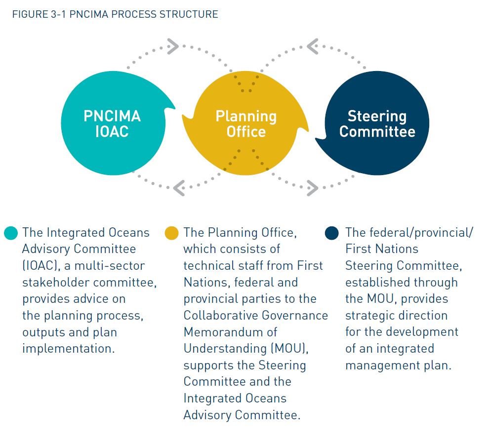
Figure 3-1 PNCIMA Process Structure
3.1 Governance Arrangements
Under the PNCIMA Collaborative Governance MOU, First Nations, Footnote 4 federal and provincial government staff worked together in a Steering Committee that provided strategic direction and executive oversight to the PNCIMA initiative. First Nations, federal and provincial technical staff worked together in a Planning Office which supported the Steering Committee and the Integrated Oceans Advisory Committee. Advice from stakeholders was formally provided by the Integrated Oceans Advisory Committee, which is described in further detail in Section 3.2.
All organizations and individuals who engaged in different components of the PNCIMA process are identified in Appendix 5. The PNCIMA process structure is outlined in Figure 3-1.
First Nations party to the Collaborative Governance MOU coordinated their participation in the PNCIMA Steering Committee through a First Nations Governance Committee consisting of First Nations leaders from Haida Gwaii, the North Coast and the Central Coast, with technical support at the PNCIMA Planning Office from several organizations, including the Coastal First Nations – Great Bear Initiative, North Coast- Skeena First Nations Stewardship Society, Haida Fisheries Program, and the Central Coast Indigenous Resource Alliance. The Regional Committee on Oceans Management informed and coordinated federal and provincial agencies’ participation in the Steering Committee and in the Planning Office. Appendix 5 provides a list of participants on these committees.
Governance mechanisms are expected to evolve as relationships and experience continue to develop. In addition, the federal and provincial governments are committed under the PNCIMA Collaborative Governance MOU to engage and consult with First Nations that are not currently signatories to the PNCIMA Collaborative Governance MOU.
3.2 Engagement of Interested Parties

Figure 3-2 Options for Participating in the PNCIMA Process
Stakeholder participation was critical to the development of the PNCIMA plan. A detailed description of the engagement approach is provided in the PNCIMA Initiative Engagement Strategy (PNCIMA 2010c). To achieve effective participation, a variety of tools and mechanisms were developed to encourage ongoing engagement and to document the views and knowledge of stakeholders, communities and the general public. These tools and mechanisms are outlined in Figure 3-2. A list of public forums and meetings that were held is provided in Appendix 6.
The PNCIMA Integrated Oceans Advisory Committee (IOAC) was a central component of the PNCIMA planning process and was essential in facilitating ongoing engagement with stakeholders as the process evolved. The IOAC was established as a multi-sector advisory body to provide guidance on the planning process, its outputs and the implementation of the integrated management plan. The IOAC consisted of participants from industry, regional districts, recreational groups, environmental non-governmental organizations and other interested parties. First Nations and federal and provincial governments participated as ex-officio members in order to provide feedback on IOAC discussions. Appendix 5 provides a list of the IOAC membership.
The PNCIMA Steering Committee considered the role of the IOAC to be important in developing the integrated management plan. Throughout the planning process, advice and recommendations from the IOAC were shared with the PNCIMA Steering Committee. Outcomes of the Steering Committee review were shared with the IOAC, which provided an opportunity to resolve differences by consensus, thereby allowing for broad support across participating sectors and interests. Following changes to the planning process in September 2011, as referenced in Section 1.4, engagement with the IOAC changed from a consensus-seeking approach to a more consultative approach. Consequently, the IOAC reached consensus on some but not all elements of the plan. The role of the IOAC is advisory in nature only. Therefore, the plan will not limit or prejudice the positions of the IOAC members in the future.
3.3 Development of the Plan
The PNCIMA planning process, outlined in Figure 3-3, was comprised of many stages, over many years. Once the collaborative planning process was developed and existing information was assembled and assessed, parties began working on developing an EBM framework for PNCIMA.
The framework was jointly developed over the course of 2010, 2011 and 2012 by collaborative governance partners and the IOAC. First, the parties developed a definition of EBM for PNCIMA. Second, assumptions, principles, goals and objectives for the area were formulated. Then strategies that support the overall goals and objectives for PNCIMA were identified. It is important to note the scale and complexities associated with implementing all aspects of each strategy. In order to address this, a number of priorities were identified for short-term implementation.
Management and decision support tools for identifying management issues in PNCIMA were developed concurrently with the EBM framework. In 2012, DFO developed a pilot ecological risk assessment framework to assist with identifying ecological components at greatest risk from human activities (DFO 2012a). This tool continues to be developed and refined. The lack of a decision support tool related to socio-economic and cultural activities in PNCIMA has been identified as a significant gap. Ongoing work on cumulative effects assessment throughout the province has indicated that a collaboratively developed assessment tool or framework would also be useful for PNCIMA.
Together, PNCIMA’s EBM framework, information base and decision support tools form the foundation for integrated ocean management in the area, and will support and enable integrated management within other planning, regulatory and decision-making processes.

Figure 3-3 PNCIMA Initiative Timeline
3.4 Related Marine Planning Processes
While the PNCIMA process has focused on developing a strategic level plan for the area, many other marine-based planning processes are under way at various scales both within and adjacent to PNCIMA. The intended role of the PNCIMA plan is to provide an overarching marine EBM framework that is available to guide marine planning and management at these other scales.
A variety of land use plans provide direction on the use and allocation of resources in coastal B.C. Participants in these planning processes recognized that upland activities could have a major bearing on the marine environment, and agreed that more comprehensive integrated marine use planning should be undertaken following completion of regional land use plans. Furthermore, a number of the resulting land use agreements led to the designation of coastal protected areas (which include the marine environment), which require complementary nearshore and foreshore marine planning. Land use plans for areas adjacent to the PNCIMA planning area include the Central Coast and North Coast Land and Resource Management Plans (Coast Land Use Decision), Council of the Haida Nation/B.C. protected area management plans on Haida Gwaii, and the Vancouver Island Regional Land Use Plan. The Nisga’a Final Agreement defines the rights of the Nisga’a Nation with respect to marine and freshwater resources in the Nass area at the northern extent of the planning area.
Marine use plans exist at different scales within the PNCIMA boundary, and include the Johnston Strait-Bute Inlet Coastal Plan, Quatsino Sound Coastal Plan, and North Island Straits Coastal Plan. In addition, the Marine Plan Partnership for the North Pacific Coast (MaPP), a partnership between the Province of British Columbia, Coastal First Nations – Great Bear Initiative, North Coast–Skeena First Nations Stewardship Society and Nanwakolas Council, has developed a Regional Action Framework and sub-regional coastal and marine plans for the North Coast, the Central Coast, North Vancouver Island and Haida Gwaii. The federal government was not involved in the MaPP planning process. The MaPP initiative shares the same footprint as PNCIMA and draws from, and builds on, the PNCIMA plan. For example, MaPP adopted the EBM framework established through the PNCIMA initiative. MaPP partners worked with stakeholders and the public to develop strategies and spatial plans that will inform the development, use and protection of marine spaces throughout the area.
A number of the First Nations have developed plans and management tools at multiple scales. These include community, sub-regional and regional integrated marine use plans comprised of goals, objectives, strategies, collaborative government relationships, spatial management and various partnerships with stakeholders.
The PNCIMA planning process also has linkages to a number of marine protected areas. Planning within the Gwaii Haanas National Marine Conservation Area Reserve and Haida Heritage Site will help achieve some of the goals and objectives outlined within this PNCIMA plan. Information gathered by Parks Canada and the Council of the Haida Nation was available to the PNCIMA initiative throughout the plan’s development. Similarly, Environment and Climate Change Canada’s Canadian Wildlife Service is leading an initiative to establish a National Wildlife Area in the marine waters surrounding the Scott Islands off the northwestern tip of Vancouver Island. This proposed protected marine area would conserve the marine foraging habitat of the largest seabird colony in British Columbia as well as conserve the marine habitats for other wildlife that uses the area. DFO has also proposed that the Hecate Strait/Queen Charlotte Sound glass sponge reefs be designated as a candidate marine protected area, which would provide comprehensive and long-term management and protection for this unique area. In 1997 the CHN designated SG̲áan K̲ínghlas as a Haida marine protected area. In 2008 DFO designated Bowie Seamount as a Marine Protected Area (MPA) under Canada’s Oceans Act. Respecting the collaborative approach to the area’s planning and management, it is commonly referred to as the SG̲áan K̲ínghlas – Bowie Seamount (SK̲-B) MPA. Although the area is outside the PNCIMA boundary, there are ecological linkages to PNCIMA.
Additionally, the Province of British Columbia has been working with First Nations in the Haida Gwaii and the Central and North Coast planning regions to identify areas for conservancy/protected area establishment, which includes protection of the marine foreshore. In addition to protecting biodiversity and recreation values, conservancies/ protected areas expressly recognize the importance of some natural areas to First Nations for food, social, ceremonial and cultural uses. Marine foreshore areas for the conservancies/ protected areas in the Haida Gwaii and North Coast planning regions were identified and established through broader strategic land use planning processes that also provide certainty for users and support sustainable economic opportunities for coastal communities. The conservancies/protected areas protect a high diversity of marine landscapes and habitats, including productive estuarine complexes, sea grass meadows, kelp forests and internationally significant seabird nesting colonies. Their selection was based in part on an analysis of ecosystem representation and special feature conservation. In the Central Coast planning region, the Province of British Columbia and First Nations are using management planning processes to identify marine foreshore areas that can be added to coastal conservancies. Detailed values, aspirations and uses for each conservancy are being considered and incorporated into individual protected area management plans.
In addition to these multi-user planning processes, it will be important to consider sector-specific planning and management at various scales during implementation of the PNCIMA plan. DFO develops Integrated Fisheries Management Plans to manage the fishery of a particular species in a given region. These plans combine the best available science on a species with industry data on capacity and methods for harvesting that species. Internationally, Canada is a member of the North Pacific Anadromous Fish Commission and the Western and Central Pacific Fisheries Commission. Additionally, the Pacific Salmon Treaty, signed by Canada and the United States in 1985, provides the framework in which the two countries work together to conserve and manage Pacific salmon.
The Canadian Marine Advisory Council is Transport Canada’s national consultative body for marine matters. Participants include individuals and representatives of parties that have a recognized interest in boating and shipping. The Council addresses concerns regarding safety, recreational matters, navigation, marine pollution and response, and marine security. Internationally, Canada is a member of the International Maritime Organization, whose mission statement is “Safe, secure and efficient shipping on clean oceans” (IMO 2011). There are also ongoing tripartite discussions between the federal government, provincial government and First Nations regarding shipping and transportation issues and related planning.
4.0 Ecosystem-Based Management Framework
Ecosystem-based management is an adaptive approach to managing human activities that seeks to ensure the coexistence of healthy, fully functioning ecosystems and human communities. The intent is to maintain those spatial and temporal characteristics of ecosystems such that component species and ecological processes can be sustained and human well-being supported and improved. Footnote 5
Understanding of EBM in B.C. has evolved in recent years. The concept was used in relation to land use planning as part of the implementation of the 2001 Central Coast Land and Coastal Resource Management Planning Phase I Framework Agreement. Through this process, the Province of British Columbia, First Nations from the Central and North Coasts and Haida Gwaii, local governments and non-government interests reached consensus on establishing a definition, principles and goals for EBM. Parties to the agreement made a commitment to implement EBM in coastal B.C. as a means of achieving “healthy, fully functioning ecosystems and human communities”.
Canada’s 2002 Policy and Operational Framework for Integrated Management of Estuarine, Coastal and Marine Environments places equal importance on EBM. It identifies EBM as a fundamental principle by which integrated management should be guided, and states that the identification of EBM objectives and reference levels will guide the development and implementation of management in order to achieve sustainable development.
EBM, although not a term used historically by First Nations, has been their way of practicing stewardship for thousands of years, using a number of similar principles such as “interconnectedness,” “sharing,” “balance,” “learning” and honouring the Creator/creation, as taught by their ancestors.
Through the PNCIMA initiative, many of the same parties involved in the land use planning process, and others with interests in the marine environment, came together again to define EBM for marine ecosystems. The result of this collaboration was an EBM framework that is the central feature of the PNCIMA plan. Figure 4-1 depicts the various components of the EBM framework for PNCIMA. The uppermost components (definition, assumptions and principles) provide broad guidance to the plan. Components that are in the middle of the framework (goals, objectives, strategies) are more specific statements that are based on an understanding of key issues and are identified through various analyses. The lower components of the diagram illustrate an adaptive management cycle in which strategies are adapted based on monitoring and evaluating the results of implementation.

Figure 4-1 Components of the PNCIMA Ecosystem-Based Management (EBM) framework
Case Study: First Nations Culture, the Marine Environment and Ecosystem-Based Management
Respect for the land, sea, spirit world and all living things is at the heart of First Nations interactions with nature. Coastal First Nations have been practising ecosystem-based management of the land and sea for countless generations. The understanding that humans are part of the ecosystem, a concept that is reflected in EBM principles, is integral to First Nations values, beliefs and approaches to land and marine stewardship (Jones et al. 2010). The understanding that “everything depends on everything else” is also the basis for all First Nations marine use plans. For example, from the Haida perspective:
Haida culture is intertwined with all of creation in the land, sea, air and spirit worlds. Life in the sea around us is the essence of our well-being, and so our communities and culture. We know that our culture depends on the sea around us, and that the well-being of every community and Nation is at risk. It is imperative that we bring industrial marine resource use into balance with, and respect for, the well-being of life in the sea around us.
EBM provides the foundation for addressing many marine issues that are being discussed at community-based, sub-regional and regional marine use planning tables. These issues include fisheries sustainability, conservation, habitat protection, marine-based economic development, and monitoring and enforcement. Through joint planning processes, the provincial and federal governments and First Nations developed a set of EBM principles and goals that promote marine ecosystem health and restoration alongside social, cultural and economic well-being. These EBM principles and goals will help guide marine use management at multiple scales and across many marine activities in PNCIMA.
4.1 EBM Assumptions and Principles for PNCIMA
Assumptions
- Ecosystem goods and services underlie and support human societies and economies; such goods and services can be direct or indirect.
- Humans and their communities are part of ecosystems, and they derive social, cultural and economic value from marine ecosystem goods and services.
- Human activities have many direct and indirect effects on marine ecosystems.
- EBM informs the management of human activities.
- Marine ecosystems exist on multiple spatial and temporal scales, and are interconnected.
- Marine ecosystems are dynamic and subject to ongoing and sometimes unpredictable change.
- Marine ecosystem states have limits to their capacity to absorb and recover from impacts.
- Human understanding of marine ecosystems is limited.
- Humans prefer some ecosystem states more than others.
- Humans can manage some drivers of change better than others, and can adjust or respond to some changes better at the scale of PNCIMA planning.
Principles
- The EBM approach seeks to ensure ecological integrity. It seeks to sustain biological richness and services provided by natural ecosystems, at all scales through time. Within an EBM approach, human activities respect biological thresholds, historical levels of native biodiversity are met, and ecosystems are more resilient to stresses and change over the long term.
- The EBM approach includes human well-being. It accounts for social and economic values and drivers, assesses risks and opportunities for communities, and enables and facilitates local involvement in sustainable community economic development. An EBM approach aims to stimulate the social and economic health of the communities that depend on and are part of marine ecosystems, and it aims to sustain cultures, communities and economies over the long term within the context of healthy ecosystems.
- The EBM approach is precautionary. It errs on the side of caution in its approach to management of human activity and places the burden of proof on the activity to confirm that management is meeting designated objectives and targets. Uncertainty is recognized and accounted for in the EBM approach.
- The EBM approach is adaptive and responsive in its approach to the management of human activities. It includes mechanisms for assessing the effectiveness of management measures and changing such measures as necessary to fit local conditions.
- The EBM approach includes the assessment of cumulative effects of human activities on an entire ecosystem, not just components of the ecosystem or single sector activity.
- The EBM approach is equitable, collaborative, inclusive and participatory. It seeks to be fair, flexible and transparent, and strives for meaningful inclusion of all groups in an integrated and participatory process. EBM is respectful of federal, provincial, First Nations and local government governance and authorities, and recognizes the value of shared responsibility and shared accountability. It acknowledges cultural and economic connections of local communities to marine ecosystems.
- The EBM approach respects Aboriginal rights, Aboriginal titles and treaty rights, and supports working with First Nations to achieve mutually acceptable resource planning, stewardship and management.
- The EBM approach is area-based. Management measures are amenable to the area in which they are applied; they are implemented at the temporal or spatial scales required to address the issue and according to ecological rather than political boundaries.
- The EBM approach is integrated. Management decisions are informed by consideration of interrelationships, information, trends, plans, policies and programs, as well as local, regional, national or global objectives and drivers. The EBM approach recognizes that human activities occur within the context of nested and interconnected social and ecological systems. As such, EBM concurrently manages human activities based on their interactions with socialecological systems. The approach helps to direct implementation of measures across sectors to integrate with existing and, where agreed, new management and regulatory processes.
- The EBM approach is based on science and on wise counsel. It aims to integrate the best available scientific knowledge and information with traditional, intergenerational and local knowledge of ecological and social systems and adapt it as required.
4.2 Goals, Objectives and Strategies for PNCIMA
PNCIMA’S EBM goals are interconnected and cannot be taken as separate from one another. It is the purpose of the PNCIMA EBM Framework to achieve:
- integrity of the marine ecosystems in PNCIMA, primarily with respect to their structure, function and resilience
- human well-being supported through societal, economic, spiritual and cultural connections to marine ecosystems in PNCIMA
- collaborative, effective, transparent and integrated governance, management and public engagement
- improved understanding of complex marine ecosystems and changing marine environments
The EBM objectives for PNCIMA, as outlined in Table 4-1, were developed through a collective effort. The IOAC carefully considered how to best reach the PNCIMA goals, and worked to develop EBM objectives which were subsequently reviewed by all collaborative governance parties. The objectives that appear in the plan reflect the recommendations made by the IOAC, as well as input from the PNCIMA Steering Committee. They are applicable to PNCIMA as a whole but can be equally applied to planning, management and decision-making at other spatial scales within the area. As with the goals, these objectives are interconnected.
Management strategies and associated timelines for advancing PNCIMA objectives are outlined in Table 4-1. Strategies may influence the outcome of more than one objective; therefore, some duplication is present. Specific actions are not identified in the EBM framework. They will be identified on a case-by-case basis through work planning as particular strategies are implemented.
Strategies relate to the authorities and priorities of various departments, agencies and organizations. They are not meant to be implemented in isolation or by a single department, agency, organization or individual. Rather, they are meant to integrate EBM into the regular course of business for all governments, First Nations and stakeholders involved in PNCIMA. Therefore, responsibility for implementing particular strategies is shared among all parties to the PNCIMA initiative.
Defining goals, objectives, and strategies
Goals relate to the broad purpose and expected end result of the planning initiative, and apply to the whole plan area. They reflect broad ideals, aspirations or benefits pertaining to specific environmental, economic or social issues, and are the general ends towards which efforts are directed. Goals answer the question, “What must be accomplished to realize what we want?” They are achieved through objectives, strategies and actions.
Objectives also describe a desired future state but are more specific and concrete than goals. They are the means of reaching the goals. They answer the question, “What steps are required to achieve the goal?”
Whereas objectives define “what” outcome is intended for particular resource values, strategies describe “how” the desired outcome will be achieved. They answer the question, “What measures or actions are required to make progress towards achieving the goals and objectives?”, and they correspond directly to the objective they serve.
Table 4-1 Goals, objectives and strategies for PNCIMA
| Objective Footnote 6 | Strategy | Timeline |
|---|---|---|
| 1.1 Conserve the diversity of species, viable populations and ecological communities and their ability to adapt to changing environments. | 1.1.1 Update and enhance understanding and knowledge of ecological communities. | Ongoing |
| 1.1.2 Update and enhance work to identify and characterize risks to species diversity, population viability and ecological communities. | Ongoing | |
| 1.1.3 Update and enhance existing spatial and analytical information on species diversity, population viability and ecological communities. | Long term | |
| 1.1.4 Assess existing management measures for their ability to conserve species diversity, population viability and ecological communities. | Short term | |
| 1.1.5 Identify, assess and adapt possible management measures to address conservation of species diversity, population viability and ecological communities. | Short term | |
| 1.1.6 Support the creation of an MPA network for PNCIMA that conserves species diversity, population viability and ecological communities. | Ongoing | |
| 1.2 Conserve the productivity and trophic structure of ecosystems so their components can play their natural role in the food web. | 1.2.1 Update and enhance work to identify and characterize risks to productivity and trophic structure of ecosystem components. | Ongoing |
| 1.2.2 Update and enhance the existing knowledge base for productivity and trophic structure of ecosystems. | Ongoing | |
| 1.2.3 Assess existing management measures for ecosystem components. | Short term | |
| 1.2.4 Identify, assess and adapt possible management measures to address risks to productivity and trophic structure of ecosystems. | Short term | |
| 1.2.5 Support the creation of an MPA network for PNCIMA that conserves productivity and the trophic structure of ecosystem components. | Ongoing | |
| 1.3 Conserve habitat and water quality of the ecosystem. | 1.3.1 Update and enhance work to identify ecosystem components, including habitats. | Ongoing |
| 1.3.2 Update and enhance work to identify and characterize risks to habitats and water quality. | Ongoing | |
| 1.3.3 Assess and address knowledge gaps for habitat and water quality. | Long term | |
| 1.3.4 Assess existing management measures for habitat and water quality. | Short term | |
| 1.3.5 Identify and assess possible management measures to address identified risks to habitat and water quality, and implement as appropriate. | Short term | |
| 1.3.6 Support the creation of an MPA network for PNCIMA that conserves habitat and water quality of the ecosystem. | Ongoing | |
| 1.3.7 Protect important habitat from degradation, and pay particular attention to components of species’ life cycles. | Ongoing | |
| 1.4 Mitigate negative cumulative effects that affect ecosystem components. | 1.4.1 Update and enhance work to evaluate cumulative effects of current and future activities in PNCIMA on ecosystem components. | Ongoing |
| 1.4.2 Identify and assess possible management measures to address cumulative effects of current and future activities in PNCIMA, and implement as appropriate. | Short term | |
| 1.4.3 Use cumulative effects modelling to inform management decisions. | Ongoing |
| Objective | Strategy | Timeline |
|---|---|---|
| 2.1 Protect culturally and spiritually important marine customs, practices, traditions, areas, sites and cultural resources. | 2.1.1 Support intercultural awareness through sharing information and fostering improved understanding of cultural and spiritual values. | Ongoing |
| 2.1.2 Integrate and document traditional knowledge and other cultural information, and incorporate into management and decision-making, as appropriate. | Ongoing | |
| 2.1.3 Support priority use, subject to conservation needs, of marine resources for First Nations traditional use, including food, social and ceremonial requirements. | Ongoing | |
| 2.1.4 Support the creation of an MPA network for PNCIMA that protects culturally and spiritually important marine customs, practices, traditions, areas, sites and cultural resources. | Ongoing | |
| 2.2. Support certainty for regulatory and operational processes governing human uses of the marine environment. | 2.2.1 Promote and integrate relevant tools, analyses, information and the EBM framework into decision-making processes and policy-making. | Ongoing |
| 2.2.2 Assess compatibility of uses and facilitate spatial and temporal certainty at multiple scales. | Long term | |
| 2.2.3 Engage with First Nations, federal, provincial and local governments around issues related to licensing and approvals for current, new and emerging ocean activities, as appropriate. | Ongoing | |
| 2.2.4 Identify and assess management measures to enhance environmental services infrastructure, and implement as appropriate. | Long term | |
| 2.3. Support sustainable economic opportunities, livelihoods and economic diversification among oceanrelated businesses, industries and coastal communities. Footnote 7 | 2.3.1 Identify and assess ocean-related economic opportunities and implement management measures as appropriate to achieve sustainable economic opportunities in the region. | Short term |
| 2.3.2 Assess social, cultural and economic effects of resource management decisions on users. | Short term | |
| 2.3.3 Support the participation of First Nations in all sectors of the marine economy. | Long term | |
| 2.3.4 Identify and support development of local and global markets and efficient and affordable distribution channels. | Ongoing | |
| 2.4 Minimize conflicts among marine user groups. | 2.4.1 Assess and consider competing uses of ocean space in developing spatial and non-spatial management measures, as appropriate. | Ongoing |
| 2.4.2 Establish mechanisms and/or build on existing mechanisms to effectively support stakeholder collaboration and information sharing in ocean management advisory processes in PNCIMA. | Short term | |
| 2.4.3 Promote and integrate relevant tools, analyses, information and the EBM framework into decision-making processes, including regulatory processes and policy-making. | Ongoing | |
| 2.5 Support the maintenance of natural resource systems that deliver marine goods and services at multiple scales. | 2.5.1 Identify and characterize risks to natural resource systems that deliver marine goods and services. | Short term |
| 2.5.2 Update and enhance existing knowledge base about natural resource systems that deliver marine goods and services. | Ongoing | |
| 2.5.3 Identify and assess possible management measures to address key risks to natural resource systems that deliver marine goods and services, and implement as appropriate. | Short term | |
| 2.5.4 Identify and assess possible management measures to support healthy natural resource systems. | Short term | |
| 2.5.5 Protect fish habitat from degradation, and pay particular attention to spawning and rearing habitat. | Ongoing | |
| 2.5.6 Support the creation of an MPA network for PNCIMA that supports the maintenance of natural resource systems that deliver marine goods and services. | Ongoing | |
| 2.6 Support marine safety, marine security and accessible waters. | 2.6.1 Clarify jurisdictional roles and responsibilities with respect to marine safety, security and accessible waters. | Short term |
| 2.6.2 Assess and consider marine safety and security issues at a community scale when developing management measures. | Ongoing | |
| 2.6.3 Maintain and enhance navigational aids and communications systems and infrastructure. | Ongoing | |
| 2.6.4 Minimize potential adverse impacts of marine transportation and related activities on marine ecosystems and coastal communities while protecting accessible waters. | Ongoing | |
| 2.6.5 Assess and enhance marine emergency response training, preparation and equipment for effective response to spills or accidents at multiple scales. | Long term | |
| 2.6.6 Assess and enhance management measures to prevent accidents or spills. | Ongoing | |
| 2.6.7 Assess and enhance existing marine emergency response monitoring, information and data to develop geographic marine response plans. | Short term | |
| 2.7 Support First Nations and local communities in benefitting from the ecosystems in which they live. | 2.7.1 Identify and assess management measures that support First Nations and local communities in deriving economic benefits from the ecosystems in which they live. | Short term |
| 2.7.2 Support monitoring and enforcement partnerships that increase capacity in First Nations and local communities. | Ongoing | |
| 2.7.3 Support sustainable community economic development, including enhancement of local capacity. | Ongoing |
| Objective | Strategy | Timeline |
|---|---|---|
| 3.1. Support coordination and integration of ocean governance, management, planning and advisory processes. | 3.1.1 Foster ongoing integrated management and coordination within and among First Nations, federal, provincial and local governments | Ongoing |
| 3.1.2 Establish mechanisms and/or build on existing mechanisms, advisory committees and opportunities to effectively coordinate stakeholder advisory processes for ocean management issues in PNCIMA. | Ongoing | |
| 3.2. Provide opportunities for the participation of First Nations, federal and provincial government agencies, coastal communities, marine user groups and other interested parties in ocean management, planning and advisory processes. | 3.2.1 Establish mechanisms and/or build on existing mechanisms, advisory committees and opportunities to support stakeholder engagement in ocean management advisory processes in PNCIMA. | Short term |
| 3.3 Manage ocean resources in a manner that respects Aboriginal rights, Aboriginal titles and/or treaty rights. | 3.3.1 Develop and build on mechanisms that ensure the respect for and accommodation, where appropriate, of Aboriginal rights, Aboriginal titles and/or treaty rights in marine governance and management processes. | Ongoing |
| 3.4 Continue to build respectful relationships (including governance mechanisms) among First Nations, federal, provincial and local governments and authorities. | 3.4.1 Develop and build on existing governance and technical bodies that include First Nations in marine stewardship decision-making processes. | Short term |
| 3.4.2 Support monitoring and enforcement partnerships that improve relationships and increase capacity in First Nations and local communities. | Ongoing | |
| 3.4.3 Facilitate capacity development of First Nations, federal, provincial and local (where appropriate) governments to participate in governance and management activities. | Ongoing | |
| 3.5. Ensure all relevant interests are considered in a respectful, transparent and inclusive manner. | 3.5.1 Develop mechanisms and tools, including common engagement principles, to support respectful, transparent and inclusive stakeholder engagement in ocean management advisory processes. | Short term |
| Objective | Strategy | Timeline |
|---|---|---|
| 4.1. Promote and facilitate information sharing among First Nations, federal and provincial agencies, coastal communities and marine user groups. | 4.1.1 Promote and integrate relevant tools, analyses, information and the EBM framework into decision-making processes, including regulatory processes and policy making. | Ongoing |
| 4.1.2 Facilitate the accessibility to and exchange of environmental and socio-economic data among First Nations, federal and provincial agencies, coastal communities and marine user groups. | Ongoing | |
| 4.2. Include scientific, traditional and local knowledge and experience to inform the development of management and monitoring plans. | 4.2.1 Explore agreements and develop opportunities for collecting, sharing and incorporating different types of knowledge into management and decision-making in PNCIMA. | Ongoing |
| 4.2.2 Foster ongoing integrated management, monitoring and coordination within and among First Nations, federal, provincial and local governments. | Ongoing | |
| 4.2.3 Develop a monitoring and evaluation framework for PNCIMA that incorporates different types of knowledge, including scientific, social, cultural and economic. | Short term | |
| 4.2.4 Support monitoring and enforcement partnerships that increase capacity in local and First Nations communities. | Ongoing | |
| 4.3. Align research in PNCIMA with knowledge gaps and ocean management objectives. | 4.3.1 Update and enhance methodologies and tools to improve knowledge and understanding of human use data and human well-being. | Short term |
| 4.3.2 Update and enhance existing spatial information on key marine resources, habitats, trends and uses, with an emphasis on high-risk areas. | Ongoing | |
| 4.3.3 Support ongoing partnerships in order to align academic research with current management needs. | Ongoing | |
| 4.4. Adapt ocean management to respond to new information and knowledge. | 4.4.1 Develop and apply a monitoring and evaluation framework for integrated management. | Short term |
| 4.4.2 Develop tools, including adaptive management plans, to improve the use of monitoring data for the timely adaptation of management policies and programs. | Long term | |
| 4.5. Promote awareness, outreach and education to improve public understanding and stewardship of marine environments. | 4.5.1 Develop a communication plan that makes planning information available, understandable, timely and accessible to the public. | Short term |
Case Study: Gwaii Haanas National Marine Conservation Area Reserve and Haida Heritage Site
Gwaii Haanas, “islands of beauty” in Haida, is a 5000 km² land-and-sea protected area in southern Haida Gwaii, an island archipelago in the northwestern part of PNCIMA. Gwaii Haanas is managed cooperatively by the Government of Canada and the Council of the Haida Nation through the Archipelago Management Board.
The Haida Nation designated both the land and sea areas of Gwaii Haanas as a Haida Heritage Site in 1985. Soon after, the terrestrial area of Gwaii Haanas was established as a National Park Reserve by the Government of Canada. In 2010, the Government of Canada established the Gwaii Haanas National Marine Conservation Area Reserve and Haida Heritage Site under the Canada National Marine Conservation Areas Act. The Council of the Haida Nation and the Government of Canada are committed to managing Gwaii Haanas cooperatively through the Gwaii Haanas Agreement (1993) and the Gwaii Haanas Marine Agreement (2010).
The marine area of Gwaii Haanas is currently managed under an Interim Management Plan. Through this plan, 3% of the area is in zones of full protection. An additional 13.6% (472 km²) is zoned as DFO-designated Rockfish Conservation Areas, in which hook-and-line fisheries are prohibited. Current human uses of the Gwaii Haanas marine area include Haida traditional activities, commercial and recreational fishing, and a range of tourism activities.
The Archipelago Management Board is developing an integrated land-sea-people management plan for Gwaii Haanas, to be completed in 2017. Gwaii Haanas National Marine Conservation Area Reserve and Haida Heritage Site is located within PNCIMA. The Gwaii Haanas plan includes management goals, objectives, targets and a spatial zoning plan. The Archipelago Management Board has been developing the plan with advice from an advisory committee, local communities, the fishing industry, tour operators and other stakeholders.
5.0 Implementation
The success of the PNCIMA plan depends on continued participation, support and commitment from the Government of Canada (and its various departments), the Province of British Columbia, participating First Nations, local governments and stakeholders to advance its objectives and implement its strategies. A collaborative approach to plan implementation will help ensure the coexistence of healthy, fully functioning ecosystems and human communities.
A true measure of the plan’s success will be how well the EBM framework and its associated tools are integrated into the regular course of business for federal, provincial and First Nation governments, along with stakeholders.
The PNCIMA plan identifies five priorities for short-term implementation. These priorities will be implemented within existing programs and resources, where possible. Some strategies and associated actions may ultimately lead to the identification of new work which will be implemented as funding permits.
5.1 Priority Setting for Action
Coastal Stewardship Network
The Coastal Stewardship Network is a First Nations-managed program that supports the stewardship and monitoring of the marine, terrestrial and cultural resources of the North and Central Coasts and Haida Gwaii, and the impact of management practices implemented under ecosystembased management.
A key component of the program is a Regional Monitoring System, which has been designed to:
- develop a standardized approach to monitoring priority issues;
- provide tools for communities to collect, store and retrieve data;
- compile and compare coast-wide data for use by communities and others; and
- empower communities to use the information in planning and decision-making.
Coastal Stewardship field staff in First Nations communities within PNCIMA monitor indicators of the health of plants and animals that have ecological and cultural importance, as well as broader ecosystems in order to track changes and impacts from resource activities. The Network has also developed an online data management system, which allows local Coastal Stewardship staff to compile data from their programs, share information, analyze regional trends and report information in ways that meet the needs of their communities.
The Coastal Stewardship Network is one example of an innovative initiative that may be used to help implement the PNCIMA plan, specifically in relation to supporting monitoring and enforcement partnerships.
For more information, please visit coastalguardianwatchmen.ca/guardian-watchmen-programs
While all of the strategies identified in the EBM framework are important elements of a holistic approach to EBM in PNCIMA, five priorities that address many of the EBM strategies will be the focus of plan implementation. This does not preclude action from being taken on other strategies identified in the plan, but it is expected that many of those strategies will be implemented over the longer term. Continued collaboration and integration will be essential as work on the priorities is conducted.
The following priorities have been identified to address PNCIMA EBM goals:
- governance arrangements for implementation
- marine protected area network planning
- monitoring and adaptive management
- integrated economic opportunities
- tools to support plan implementation
Implementation of these priorities will be based on the recognition that they relate to and support one another, in the same way that elements of the EBM framework are interconnected. Collaborative development of work plans associated with these priorities and shared implementation will strengthen that integration. Other planning processes can assist with implementation of some of the priorities discussed below.
Governance arrangements for implementation
Successful implementation of the plan will depend on maintaining and supporting an ongoing governance arrangement that is flexible enough to address implementation needs as they arise. Ongoing implementation of the plan will also be dependent on continued engagement and involvement of diverse stakeholders.
Enduring governance and engagement processes will provide accountability regarding the plan’s implementation; make important connections to ongoing work to which PNCIMA’s EBM framework, information base and associated tools can contribute; and provide a venue for continued integrated management of marine use within PNCIMA.
Next steps under this priority include:
- revising the 2008 PNCIMA Collaborative Governance MOU to reflect a collaborative governance model that will facilitate First Nations, federal and provincial oversight of the implementation of the PNCIMA plan;
- fostering transparent stakeholder engagement through ongoing communications and advisory processes;
- facilitating the accessibility to and exchange of environmental and socio-economic data among First Nations, federal and provincial agencies, coastal communities and marine user groups;
- integrating the PNCIMA EBM framework, including social, cultural and socio-economic considerations, into current fisheries management and marine policy initiatives (e.g., sustainable fisheries framework, forage fish policy, cumulative effects, benthic habitat policy, management strategy evaluations); and
- integrating with other processes and different scales of planning, as appropriate, to support implementation of the PNCIMA plan.
Marine protected area network planning
The governments of Canada and British Columbia jointly developed the Canada–British Columbia Marine Protected Area Network Strategy. The MPA network strategy will guide systematic conservation planning on the Pacific Coast of Canada. The MPA network’s key purpose will be to safeguard biodiversity and ecosystem integrity. This in turn will safeguard communities and ensure that future generations will inherit the beauty and productivity of the Pacific Ocean. The Strategy is consistent with and guided by the National Framework for Canada’s Network of Marine Protected Areas.
The Strategy identifies a vision and goals and guiding principles for the design of a network of MPAs in Canada’s Pacific waters, with implementation occurring at the bioregional scale beginning in the Northern Shelf Bioregion (the boundary of which aligns with PNCIMA). A network of MPAs for the Northern Shelf Bioregion will be collaboratively developed among First Nations, federal and provincial governments. Implementation plans will be developed with input from local governments and stakeholders so that the unique ecological, socio-political, economic and cultural characteristics of different regions of coastal British Columbia are respected.
The Strategy states that “First Nations’ support and participation is an essential part of creating an effective MPA network. The special relationship between the Crown and First Nations will be provided for; both governments will respect the continued use of MPAs by First Nations for food, social and ceremonial purposes and other traditional practices, provided that these uses are consistent with the objectives for the MPA. The establishment of any MPA will not affect ongoing or future treaty negotiations or agreements and will seek to address opportunities for First Nations to benefit from MPAs.”
Currently, each planning process in the Northern Shelf Bioregion (e.g., MaPP, PNCIMA, Gwaii Haanas) has its own associated advisory body. Many of these advisory bodies are associated with MPAs, involve similar stakeholders and address similar issues. Terms of engagement are not consistent, however, and despite ongoing work to address duplication of effort between processes, improvements are always possible.
Next steps for MPA network development in the Northern Shelf Bioregion include:
- developing an enduring collaborative governance structure for MPA network planning and management that adopts or expands existing governance structures, as appropriate;
- identifying ecological, social, cultural and economic objectives and zoning designations for a Northern Shelf Bioregion MPA network;
- compiling and sharing best available scientific data and traditional and local knowledge, where appropriate;
- reviewing how existing conservation and protection tools in the Northern Shelf Bioregion contribute to the MPA network objectives, and identifying sites and recommended tools for area-based protection;
- proposing a timeline and identifying resource requirements for the development of this MPA network that integrate with existing planning and governance processes, where possible;
- coordinating regional and sub-regional stakeholder engagement for MPA network planning, and identifying common principles for engagement; and
- incorporating inputs from other processes and scales of planning (e.g., MaPP) to support development of an MPA network for the Northern Shelf Bioregion.
Monitoring and adaptive management
The effects of human behaviour on complex ecological and social systems are not easily predicted and create significant uncertainty. Monitoring and research enable management progress in the face of these uncertainties.
Adaptive management is a monitoring and management approach that assists in decisionmaking related to science-based processes. It is a prescriptive, formalized, systematic method that enables management to learn from the outcomes of implemented management actions. The process involves several interrelated steps:
- collecting and synthesizing existing knowledge (baseline);
- identifying and monitoring indicators;
- evaluating outcomes by using pre-determined strategies; and
- exploring alternative actions through the forecasting of outcomes.
Collectively, these steps create a mechanism for evaluating whether or not the plan is achieving desired goals and objectives.
Indicators are required to monitor the health of the ecosystem or its components. In an EBM context, it is equally important to understand human well-being, which requires indicators for society, economy, culture and governance. The use of a suite of predictive EBM indicators will assist in understanding the underlying processes that drive change. Targets are also needed as reference points that correspond to the state and direction of the indicator, and which can be used to guide management action.
Opportunities exist to build on an extensive body of work that has been conducted or is currently under way in order to provide baseline ecosystem assessments and identify indicators. This work includes State of the Oceans reporting, development of lists of valued ecosystem and socio-economic components, Ecosystem Status and Trends reporting, State of the Environment reporting, monitoring plans for individual MPAs, and marine planning outputs undertaken at different scales, such as through MaPP.
Next steps for this priority include:
- developing a monitoring and adaptive management framework for PNCIMA that integrates with other processes and different scales of planning, as appropriate. The framework will include but will not be limited to identifying ecological, socio-economic and cultural indicators and targets.
Integrated economic opportunities
The value of integrated management lies in bringing many different users together to address issues, discuss potential opportunities to collaborate, create efficiencies and build trust in order to foster enduring relationships.
A commitment to ecosystem-based management requires a commitment to achieving healthy, fully functioning ecosystems and human communities.
A key component of this commitment is ensuring that sustainable economic opportunities and diversification among ocean-related businesses support all users. Economic opportunities are also identified as a priority in the MaPP plans.
Next steps under this priority include:
- assessing current and emerging social and cultural conditions in PNCIMA and the economic opportunities available to PNCIMA sub-regions; and
- assessing social, cultural and economic effects of resource management decisions on users.
Tools to support plan implementation
Application of an ecosystem-based approach to management requires a strong foundation in science, including the incorporation of traditional and local knowledge. Planners and scientists have developed a suite of tools to promote a better understanding of ecological and human systems and to implement society’s goals for the marine environment. PNCIMA priority implementation will focus on developing tools for assessing risk and cumulative effects. In addition, tools developed through other planning processes will also help inform the implementation of the strategies.
Risk assessment tools
In general, risk assessments seek to identify the best management option to mitigate, reduce or eliminate stressors to species, communities and ecosystems. In PNCIMA, it will be important to identify and address risks by using a targeted and stressors-based approach that is strategic, feasible, responsive and results-oriented.
Fisheries and Oceans Canada has developed an ecological risk assessment framework to assess the potential risk to valued ecosystem components from human activities and their associated stressors (DFO 2012a). This framework may be helpful in beginning to identify management issues that arise from the environmental effects of human activities, and may guide future action in PNCIMA.
The framework uses a modular risk assessment methodology to determine single and cumulative risk to valued ecosystem components, and ultimately, to rank stressors/valued ecosystem components based on single and cumulative risks from human activities. DFO’s proposed process for developing a list of valued ecosystem components is under development, and is presented in Appendix 7. The ecological risk assessment framework is intended to help assess the relative risk to ecosystems, and it provides methods for explicitly capturing, reporting, and incorporating uncertainties in data quality, which may guide decision-making for future management strategies and actions.
While a risk assessment framework is an appropriate decision support tool for analyzing risks to valued ecosystem components, it may or may not be appropriate for other social, economic, or cultural components. Feedback throughout the planning process has consistently indicated that understanding and assessment of ecological issues has been well developed for PNCIMA, but equivalent consideration of social, cultural and economic issues and risk tolerance is required to better assess how human well-being is affected by sources of stress on the ecosystem.
Application of the risk assessment framework will provide a starting point for management and regulatory gap analysis to determine whether additional management measures are necessary to address risks to valued ecosystem components. The ecological risk assessment framework will be a useful tool for comparing various management scenarios that could be proposed based on the results of this work, and will also aid in identifying areas of uncertainty that require further research or assessment.
In addition to the DFO ecological risk assessment framework, other risk assessment tools may help inform the implementation of this plan.
Next steps for risk assessment tools include:
- reviewing and assessing new and existing tools and ensuring that they are user-friendly and understandable to managers;
- collaboratively developing risk assessment tools for PNCIMA;
- developing methods to incorporate traditional and local knowledge into risk assessment;
- developing methods to incorporate socioeconomic values and interests into risk assessment; and
- collaboratively undertaking an ecological risk assessment for PNCIMA.
Cumulative effects framework
Cumulative effects arising from human use of marine goods and services can result from multiple sectors competing for and using the same finite resources. Historical sector/ resource-based decision-making, different approaches to assessment and management, and changing marine environments have contributed to cumulative effects on marine ecosystems (Halpern et al. 2008; Crain et.al. 2009). This may cause risks to key ecological values in some areas, affect Aboriginal rights, Aboriginal titles and/or treaty rights, and create uncertainty and instability for all users.
The Province of British Columbia is implementing a cumulative effects framework that will help provide better, more sustainable management outcomes for identified values; support for assessing impacts to First Nations interests and rights, and; more efficient, consistent and transparent decision making.
The framework indentifies economic, environmental, cultural and social values that will serve as the baseline for assessment. Through implementation, the Province envisions developing cumulative effects decision support tools that are applicable to all proposed projects and authorizations, and broad scale assessments to assist with strategic level consideration and management over larger areas. A number of land-based assessments are underway, and there is interest in expanding the framework to the marine area.
Next steps for this tool include:
- establishing a cumulative effects working group that involves First Nations, federal and provincial governments in order to streamline efforts in assessing cumulative effects and developing a methodology that is consistent across organizations. The working group will engage stakeholders in the review of proposed methodologies and cumulative effects assessments.
Work planning for PNCIMA implementation
The plan’s implementation will be achieved through the collaborative development of work plans that clarify the accountability of parties to the initiative and indicate specific actions and timelines for completion. Federal and provincial agencies, First Nations and stakeholders will play essential roles in ensuring that plan implementation is focused and relevant.
The general approach for work planning for PNCIMA implementation is anticipated to include:
- establishment of work planning teams
- identification of performance measures and baseline information
- development of individual work plans for specific priorities
- implementation of work plans
- updates on progress made
- measurements of performance
Work planning will reflect individual and collective priorities and will recognize work that is ongoing at different scales, such as MaPP and First Nations marine planning initiatives. It will respect the jurisdictional authorities of each party, and will engage with stakeholders who have a particular interest in the strategy or management measure at issue.
5.2 Plan performance monitoring and evaluation
An essential component of plan implementation will be the development of a suite of indicators to assess plan outcomes or performance against EBM goals, objectives and strategies. The plan requires a practical and transparent reporting system to enable all participating governments, agencies and sector groups to demonstrate plan implementation by integrating its strategies into their regular courses of business.
A second aspect of PNCIMA plan performance evaluation will focus on the effectiveness of the integrated management process itself, particularly in terms of value added to those involved. Evaluation of process effectiveness may include consideration of key aspects of integrated management, such as engagement, endorsement, communication and conflict prevention/resolution. The evaluation may also include assessments of adherence to principles and objectives, as well as reviews of the effectiveness of the collaborative planning model. In general, the identification of any efficiencies gained through participation in the integrated management of PNCIMA will serve as indicators of success of the process.
The plan will undergo a review every five years to assess progress made towards the implementation of objectives and strategies. Less formal evaluations will be conducted at regular intervals to assess short-term progress on the implementation of strategies. Mechanisms for evaluation may include the use of external specialists or reviewers and the production of regular reports that describe annual progress and achievements.
Findings from the performance evaluation and reporting process, along with emerging management needs and priorities, will be considered and, where appropriate, incorporated into implementation so that the plan reflects changing circumstances and conditions as they arise. This adaptive approach will allow information about the past to feed back into management and improve the way it is conducted in the future. For example, where improved knowledge or monitoring results indicate that different strategies or management approaches would be better suited to achieving EBM goals and objectives, the parties will respond to those needs.
References
- Ban, N.C., and J. Alder. 2007. How wild is the ocean? Assessing the intensity of anthropogenic marine activities in British Columbia, Canada. Aquatic Conservation: Marine and Freshwater Ecosystems 18:55–85.
- Ban, N.C., H.M Alidina, and J.A. Ardron. 2010. Cumulative impact mapping: advances, relevance and limitations to marine management and conservation, using Canada’s Pacific waters as a case study. Marine Policy 34 (2010): 876–886.
- BC Stats. 2011. Population estimates. http://www.bcstats.gov.bc.ca/StatisticsBySubject/Demography/PopulationEstimates.aspx (Accessed January 2013).
- Beanlands, G.E., and P.N. Duinker. 1983. An ecological framework for environmental impact assessment in Canada. Dalhousie University, Institute for Resource and Environmental Studies, Halifax, N.S., and Federal Environmental Review Office, Hull, Que.
- Clark, C.I., and G.S. Jamieson. 2006. Identification of Ecologically and Biologically Significant Areas in the Pacific North Coast Integrated Management Area: Phase II—final report. Fisheries and Oceans Canada, Nanaimo, B.C. Canadian Technical Report of Fisheries and Aquatic Sciences 2686. http://www.dfo-mpo.gc.ca/Library/326796.pdf (Accessed January 2013).
- Coastal First Nations. 2009. Into the deep blue: marine ecosystem-based management. Vancouver, B.C.
- Cook, S.E. 2005. Ecology of the Hexactinellid sponge reefs on the western Canadian continental shelf. MSc thesis, University of Victoria, Victoria, B.C.
- Crain, C.M., B.S. Halpern, M.W. Beck, and C.V. Kappel. 2009. Understanding and managing human threats to the coastal marine environment. In: The year in ecology and conservation biology. R.S. Ostfeld and W.H. Schlesinger (editors). Annals of the New York Academy of Sciences 1162:39–62.
- Day, A., and M. Prins. 2012. Preliminary list valued social and economic components of the Pacific North Coast Integrated Management Area. Report to the Department of Fisheries and Oceans. Uma Consulting Ltd., Nanaimo, B.C.
- Fisheries and Oceans Canada (DFO). 2002a. Canada’s Oceans Strategy. Ottawa, Ont.
- Fisheries and Oceans Canada (DFO). 2002b. Policy and operational framework for integrated management of estuarine, coastal and marine environments in Canada. Ottawa, Ont. (Accessed February 2017).
- Fisheries and Oceans Canada (DFO). 2004. Memorandum of Understanding respecting the implementation of Canada’s Oceans Strategy on the Pacific Coast of Canada. Ottawa, Ont.
- Fisheries and Oceans Canada (DFO). 2005. Oceans Action Plan. Ottawa, Ont.
- Fisheries and Oceans Canada (DFO). 2009. The role of the Canadian Government in the oceans sector. Oceans Directorate, Ottawa, Ont.
- Fisheries and Oceans Canada (DFO). 2010. Pacific Region cold-water coral and sponge conservation strategy 2010– 2015. Vancouver, B.C. https://waves-vagues.dfo-mpo.gc.ca/library-bibliotheque/344719.pdf (Accessed February 2017).
- Fisheries and Oceans Canada (DFO). 2012. Risk-based assessment framework to identify priorities for ecosystembased oceans management in the Pacific Region. Canadian Science Advisory Secretariat (CSAS), Science Advisory Report 2012/044 (CSAS SAR - 2012/044). (Accessed August 2012).
- Fisheries and Oceans Canada (DFO). 2014. Identification of ecologically and biologically significant areas on the west coast of Vancouver Island and the Strait of Georgia, and in some nearshore areas on the North Coast: Phase II–designation of EBSAs. Canadian Science Advisory Secretariat (CSAS), Research Document - 2014/101 (CSAS resdocs - 2014/101)
- Fisheries and Oceans Canada (DFO), Coastal First Nations (CFN), and North Coast-Skeena First Nations Stewardship Society (NCSFNSS). 2008. Memorandum of Understanding on Pacific North Coast Integrated Management Area Collaborative Oceans Governance: between the Department of Fisheries and Oceans and First Nations of the Pacific North Coast (as represented by Coast First Nations and the North Coast–Skeena First Nations Stewardship Society).
- Fisheries and Oceans Canada (DFO), Coastal First Nations (CFN), North Coast-Skeena First Nations Stewardship Society (NCSFNSS) and Province of British Columbia. 2010. Addendum to the December 11, 2008 Memorandum of Understanding on Pacific North Coast Integrated Management Area Collaborative Oceans Governance: between the Department of Fisheries and Oceans and First Nations of the Pacific North Coast (as represented by Coast First Nations and the North Coast–Skeena First Nations Stewardship Society and the Province of British Columbia).
- Fisheries and Oceans Canada (DFO), Coastal First Nations (CFN), North Coast-Skeena First Nations Stewardship Society (NCSFNSS) , Province of British Columbia, and Nanwakolas Council. 2011. Addendum to the December 11, 2008 Memorandum of Understanding on Pacific North Coast Integrated Management Area Collaborative Oceans Governance: between the Department of Fisheries and Oceans and First Nations of the Pacific North Coast (as represented by Coast First Nations and the North Coast– Skeena First Nations Stewardship Society and the Province of British Columbia).
- Gardner, J. 2009. Coldwater corals and sponge conservation on Canada’s Pacific coast: perspectives on issues and options. Background paper to support discussions toward a conservation strategy. Submitted to the Organizing Committee for the workshop, Developing a Conservation Strategy for Coldwater Corals and Sponges on the Pacific Coast. Fisheries and Oceans Canada, Vancouver, B.C.
- Garibaldi, A., and N.J. Turner. 2004 Cultural keystone species: implications for ecological, conservation and restoration. Ecology and Society 9(3):1
- Government of Canada. 1997. Oceans Act. Department of Justice, Legislative Services Branch, Ottawa, Ont. http://laws-lois.justice.gc.ca/eng/acts/O-2.4/FullText.html (Accessed June 2012).
- Government of Canada. 2012. Canadian Environmental Assessment Act, 2012. Department of Justice, Legislative Services Branch, Ottawa, Ont.
- GSGislason & Associates Ltd. 2007. Economic contribution of the oceans sector in British Columbia. Prepared for Canada/British Columbia Oceans Coordinating Committee. (Accessed January 2013).
- Halpern, B.S., S. Walbridge, K.A. Selkoe, C.V. Kappel, F. Micheli, C. D’Agrosa, J.F. Bruno, K.S. Casey, C. Ebert, H.E. Fox, R. Fujita, D. Heinemann, H.S. Lenihan, E.M.P. Madin, M.T. Perry, E.R. Selig, M. Spalding, R. Steneck, and R. Watson. 2008. A global map of human impact on marine ecosystems. Science 319:948–952.
- International Maritime Organization (IMO). 2011. Introduction to IMO. http://www.imo.org/en/About/Pages/Default.aspx (Accessed January 2013).
- Irvine, J.R., and W.R. Crawford. 2011. State of the ocean report for the Pacific North Coast Integrated Management Area (PNCIMA). Fisheries and Oceans Canada, Nanaimo, B.C. Canadian Manuscript Report of Fisheries and Aquatic Sciences 2971.
- Irvine, J.R., and W.R. Crawford. 2012. State of the physical, biological, and selected fishery resources of Pacific Canadian marine ecosystems in 2011. Fisheries and Oceans Canada, Nanaimo, B.C. Canadian Science Advisory Secretariat (CSAS), Research Document 2012/072. (CSAS ResDocs - 2012/072) (Accessed January 2013).
- IUCN World Commission on Protected Areas (IUCN-WCPA). 2008. Establishing Marine Protected Area Networks – Making It Happen. Washington, D.C.: IUCN-WCPA, National Oceanic and Atmospheric Administration and The Nature Conservancy.
- J.G. Bones Consulting. 2009. Pacific North Coast Integrated Management Area (PNCIMA) Issues, challenges & opportunities: a discussion paper. Prepared for Fisheries and Oceans Canada (Pacific Region) on behalf of PNCIMA Secretariat.
- Jones, R., and T-L Williams-Davidson. 2000. Applying Haida ethics in today’s fishery. In: Just fish: ethics and Canadian marine fisheries. H. Coward, R. Ommer, and T Pitcher (editors). Memorial University of Newfoundland, Institute of Social and Economic Research, St. John’s, Nfld. pp. 100–114.
- Jones, R., C. Rigg and L. Lee. 2010. Haida marine planning: First Nations as a partner in marine conservation. Ecology and Society: 15(1):12.
- Lucas, B.G, S. Verrin, and R. Brown (editors). 2007. Ecosystem overview: Pacific North Coast Integrated Management Area (PNCIMA). Fisheries and Oceans Canada, Sidney, B.C. Canadian Technical Report of Fisheries and Aquatic Sciences 2667. https://waves-vagues.dfo-mpo.gc.ca/library-bibliotheque/328842.pdf (Accessed June 2012).
- Marliave, J.G., K.W. Conway, D.M. Gibbs, A. Lamb, and C. Gibbs. 2009. Biodiversity and rockfish recruitment in sponge gardens and bioherms of southern British Columbia, Canada. Marine Biology 156:2247–2254. doi 10.1007/s00227-009-1252-8.
- McDonald, J. 1991. The marginalization of the Tsimshian. In: Cultural ecology: the seasonal cycle: native peoples, native lands: Canadian Indians, Inuit, and Metis. B.A. Cox (editor). Carleton University Press, Ottawa, Ont. pp. 109–216.
- McDonald, J.A. 2003. People of the Robin: the Tsimshian of Kitsumkalum: a resource book for the Kitsumkalum Education Committee and the Coast Mountain School District 82 (Terrace) with the assistance of the First Nations Education Centre, Coast Mountain School District. CCI Press, Edmonton, Alta.
- Menzies, C., and C.F. Butler. 2007. Returning to selective fishing through indigenous fisheries knowledge: the example of K’moda, Gitxaala territory. American Indian Quarterly 33(3):441–464.
- Menzies, C.R., and C.F. Butler. 2008. The indigenous foundation of the resource economy of BC’s North Coast. Labour/Le Travail 61 (Spring 2008):131–149.
- Menzies, C.R. 2010. Dm sibilhaa’nm da laxyuubm gitxaała: picking abalone in Gitxaała territory. Human Organization 69(3): 213–220.
- Minister of Public Works and Government Services. 2005. Report of the Commissioner of the Environment and Sustainable Development. http://www.oag-bvg.gc.ca/internet/docs/c20050901ce.pdf (Accessed January 2013).
- Mitchell, D. and L. Donald. 2001. Sharing resources on the North Pacific Coast of North America: the case of the eulachon fishery. Anthropologica XLIII:19–35.
- Pacific North Coast Integrated Management Area Initiative (PNCIMA). 2010. The context for the PNCIMA initiative planning process.
- Pacific North Coast Integrated Management Area Initiative (PNCIMA). 2011. Atlas of the Pacific North Coast Integrated Management Area. (Accessed June 2012).
- Pew Oceans Commission. 2003. America’s living oceans: charting a course for sea change. The Pew Charitable Trusts. http://www.pewtrusts.org/en/research-and-analysis/reports/2003/06/02/americas-living-oceans-charting-a-course-for-sea-change
- Robinson Consulting and Associates Ltd. (Robinson Consulting). 2012. Socio-economic and cultural overview and assessment report for the Pacific North Coast Integrated Management Area. Victoria, B.C.
- Turner, N.J. 2003. The ethnobotany of “edible seaweed” (Porphyra abbottiae Krishnamurthy and related species; Rhodophyta: Bangiales) and its use by First Nations on the Pacific Coast of Canada. Canadian Journal of Botany 81(2): 283–293.
- U.S. Commission on Ocean Policy. 2004. An ocean blueprint for the 21st century. Final report. Washington, D.C. http://govinfo.library.unt.edu/oceancommission/documents/full_color_rpt/000_ocean_full_report.pdf (Accessed August 2012).
Glossary of terms
The following terms are part of the language associated with developing and implementing an integrated ocean management plan for PNCIMA.
- Action
- An intervention undertaken to contribute to the implementation of a strategy.
- Adaptive management
- A monitoring and management approach that assists in decision-making related to science-based processes. It is a prescriptive, formalized, systematic method that enables management to learn from the outcomes of implemented management actions.
- Biodiversity
- The variability among living organisms from all sources, including terrestrial, marine and other aquatic ecosystems and the ecological complexes of which they are part; this includes diversity within species, between species and of ecosystems.
- Community
- A social group of any size whose members reside in a specific locality, share government and often have common cultural and historical heritage. A community may also be defined in terms of collective interests, attitudes or sectors, such as those engaged in specific types of ocean use activities. Identification of community boundaries still remains elusive in many cases, particularly in urban settings.
- Conservation
- The protection, maintenance and rehabilitation of living marine resources, their habitats and supporting ecosystems.
- Cultural resource
- A human work or a place that gives evidence of human activity or has spiritual, cultural or historic meaning or value. This term is applicable to the whole and the parts that make up the whole. The term may be applied to a wide range of resources, including, but not limited to, fishing areas, cultural landscapes and landscape features, archaeological areas, structures, engineering works and artifacts.
- Culture
- The way of life, customs, institutions and achievements of a particular nation, people or group, including behaviours, beliefs, values and symbols that they accept and that are passed along from one generation to the next.
- Cumulative effects
- Environmental, social and economic changes caused by the combined and incremental effects of past, present and proposed activities and events.
- Drivers
- Typically, human activities (e.g., oil and gas development, tourism) or results of human activities (e.g., climate change) that could impact the environment or the social, cultural and economic wellbeing of communities.
- Ecological community
- An assemblage of species within a given area in which component species interact according to some ecological process (e.g., competition, predation).
- Ecological integrity
- Ecosystems that are self-sustaining and self-regulating. For example, they have complete food webs, a full complement of native species that can maintain their populations, and naturally functioning ecological processes (e.g., energy flow, nutrient and water cycles).
- Ecosystem
- A dynamic complex of plant, animal and microorganism communities and their non-living environment interacting as a functional unit.
- Ecosystem-based management
- An adaptive approach to managing human activities that seeks to ensure the coexistence of healthy, fully functioning ecosystems and human communities. The intent is to maintain those spatial and temporal characteristics of ecosystems such that component species and ecological processes can be sustained and human well-being can be supported and improved.
- Ecosystem component
- A fundamental element of the biological, physical or chemical environment which represents an explicit and tangible (i.e., measurable or observable) species, habitat, function, structure or other attribute. Ecosystem components are dynamic and subject to fluctuations and ongoing change. Because most of these changes are not predictable based on available knowledge, they create uncertainty about the future states of the system or its reaction to exploitation and management.
- Ecosystem function
- The physical, chemical and biological processes or attributes that contribute to the self-maintenance of the ecosystem.
- Ecosystem structure
- The pattern of the interrelations of organisms in time and space.
- First Nations Territories
- Geographic areas claimed by individual First Nations as the area of land that they occupy and use, and that their ancestors occupied or used.
- Geographic Marine Response Plan
- Geographic-specific response plans for marine-related incidents. They include response strategies tailored to a specific beach, shore or waterway, and are meant to avoid or minimize impact.
- Goal
- Goals relate to the broad purpose and expected end result of the planning initiative, and apply to the whole plan area. They reflect broad ideals, aspirations or benefits pertaining to specific environmental, economic or social issues, and are the general ends towards which efforts are directed. Goals answer the question, “What must be accomplished to realize what we want?” They are achieved through objectives, strategies and actions.
- Governance
- Interactions between government, other social organizations and citizens and the structures (formal and informal) through which decisions are made.
- Human well-being
- Individual well-being is related to quality of life and is influenced by factors such as family relationships, health, friends and community, culture and work. Societal well-being consists of the collective well-being of individuals, the quality of the interactions that individuals have with each other and with their social and cultural institutions, and the quality of the interactions among those institutions. Well-being may be measured by indicators for work, learning, financial security, family life, housing, social participation, leisure, health, security, culture and environment.
- Indicator
- Quantitative/qualitative statements or measured/observed parameters that can be used to describe existing situations and measure changes or trends over time.
- Integrated management
- A continuous process through which decisions are made for the sustainable use, development and protection of areas and resources. Integrated management acknowledges the interrelationships among different uses and the environments they potentially affect. It is designed to overcome the fragmentation inherent in a sectoral management approach, analyze the implications of development and conflicting uses, and promote linkages and harmonization among various activities.
- Invertebrates
- Within the plan context includes commercially and recreationally harvested marine invertebrate species, specifically red and green urchins, octopus, crab, prawn, shrimp, clams, scallops and sea cucumber.
- Local knowledge
- Current knowledge held by people within a community. It can be gained by any individual who has spent considerable time on the land or water observing nature and natural processes.
- Marine protected area (MPA)
-
A clearly defined geographical space recognized, dedicated and managed, through legal or other effective means, to achieve the long-term conservation of nature with associated ecosystem services and cultural values.
There are a number of different terms used to describe MPAs in Canada and British Columbia depending on the tool used to establish them. These include national marine conservation areas (NMCAs), national parks, marine National Wildlife Areas (NWAs), provincial parks, ecological reserves, conservancies/protected areas, wildlife management areas, and First Nations designations.
- Marine protected area network
- A collection of individual marine protected areas operating cooperatively and synergistically, at various spatial scales, and with a range of protection levels that are designed to meet objectives that a single reserve cannot achieve (IUCNWCPA 2008).
- Mitigation
- The elimination, reduction or control of the adverse environmental effects of a designated project, and including restitution for any damage to the environment caused by those effects through replacement, restoration, compensation or any other means (Government of Canada 2012).
- Monitoring
- A continuous management activity that uses the systematic collection of data on selected indicators to provide managers and stakeholders with indicators that denote the extent of progress toward the achievement of management goals and objectives.
- Natural resource system
- The ecological system that provides natural resources and the socio-economic system that contributes to the extraction, delivery and processing of natural resources from which we derive benefits.
- Objectives
- Objectives describe a desired future state but are more specific and concrete than goals. They are the means of reaching the goals. They answer the question, “What steps are required to achieve the goal?”
- Ocean acidification
- A measurable reduction in ocean pH caused by increased concentrations of carbon dioxide in seawater.
- Principle
- A fundamental or primary basis of conduct or management underlying a system or topic.
- Resilience
- The capacity of a system to absorb stresses and continue functioning.
- Risk
- The uncertainty that surrounds future events and outcomes. It is the expression of the likelihood of an adverse ecological effect occurring as a result of exposure to one or more stressors.
- Risk management
- The identification, assessment and prioritization of risks, followed by the coordinated and economical application of resources to minimize, monitor and control the probability and/ or impact of unfortunate events or to maximize the realization of opportunities.
- Sensitivity
- The ability of an organism or part of an organism to react to a stimulus.
- Stewardship
- Caring for the land, ocean and associated resources so that healthy ecosystems can be passed on to future generations.
- Strategy
- Strategies describe “how” the desired outcome will be achieved. They answer the question “What measures or actions are required to make progress towards achieving the goals and objectives?”, and they correspond directly to the objective they serve.
- Stressor
- Any physical, chemical or biological entity that can induce an adverse response. Stressors may adversely affect specific natural resources or entire ecosystems, including plants and animals, as well as the environment with which they interact.
- Sustainable development
- Development that meets the needs of the present without compromising the ability of future generations to meet their own needs (Government of Canada 1997).
- Tradition
- An inherited, established or customary pattern of thought, action or behaviour (as a social custom).
- Traditional knowledge
- Oral and written cultural, spiritual, social, environmental, ecological and economic information, which can be passed from one person to another, from generation to generation. Traditional knowledge is a combination of traditional environmental knowledge, traditional marine, land and resource use and traditional practices. It is a resilient process of information that is transformed and adapted to current knowledge.
- Trophic structure
- The feeding relationships in an ecosystem which contribute to the routes of energy flow and the patterns of chemical cycling.
- Value
- A social norm manifested as a result of history and culture. It is a shared understanding among people of what is good, desirable or just.
- Valued ecosystem components
- Elements of the natural environment that humans view as significant or valuable.
- Valued socio-economic components
- Elements of social-economic and cultural systems that humans view as significant or valuable.
Appendix 1: federal and provincial legislative and regulatory summary tables
| Entity | Primary acts, regulations and conventions | Role/responsibility | Related human activities |
|---|---|---|---|
| Indigenous and Northern Affairs Canada | Department of Indian Affairs and Northern Development Act; Indian Act; First Nations Fiscal and Statistical Management Act; First Nations Jurisdiction Over Education in British Columbia Act; First Nations Land Management Act | Mandate is to support Aboriginal people (First Nations, Inuit and Métis) and Northerners in their efforts to:
|
Skills and employment training, Land Claim and Self Government Agreements |
| Canadian Coast Guard | Oceans Act; Canada Shipping Act |
|
Marine transportation, marine recreation, marine safety |
| Canadian Environmental Assessment Agency | Canadian Environmental Assessment Act, 2012 |
|
Environmental assessment Footnote 8 of activities Footnote 9 related to tidal power generation, transmission lines, mining, all season runway extensions, marine terminals |
| Canadian Heritage | Cultural Property Export and Import Act |
|
Marine recreation |
| Environment and Climate Change Canada | Migratory Birds Convention Act; Canada Wildlife Act; Species at Risk Act; Canadian Environmental Protection Act; Fisheries Act section 36(3), International conventions including Convention on Biological Diversity, Convention on the Prevention of Marine Pollution by Dumping of Wastes and Other Matter (1972 London Protocol), and Convention for the Prevention of Pollution from Ships (Marpol) |
|
Marine transportation, renewable ocean energy, aquaculture, ocean disposal, protected areas, hunting of waterfowl |
| Fisheries and Oceans Canada | Fisheries Act (Fishery Regulations; Pacific Fishery Regulations; Foreign Vessel Fishing Regulations; Management of Contaminated Fisheries Regulations; Pacific Fishery Management Area Regulations; Aboriginal Communal Fishing Licences Regulations); Oceans Act (regulations have been written for specific marine protected areas, none within PNCIMA); Coastal Fisheries Protection Act (Coastal Fisheries Protection Regulations); Fisheries Development Act; Department of Fisheries and Oceans Act; Species at Risk Act; Fishing and Recreational Harbours Act |
|
Commercial fishing, sport fishing, Aboriginal fishing, aquaculture, protected areas, commercial whaling and sealing, hunting of sea otters and waterfowl, renewable ocean energy, marine transportation, marine tourism, log dumping/ handling and storage in coastal waters, marinas and ports, ocean disposal, undersea cables and pipelines |
| Global Affairs Canada | United Nations Convention on Law of the Sea |
|
Commercial fishing, national defence and public safety |
| Innovation, Science and Economic Development Canada | Telecommunications Act |
|
Marine tenures, undersea cables and pipelines |
| Department of National Defence and the Canadian Armed Forces | National Defence Act |
|
National defence and public safety |
| Natural Resources Canada | Canada Petroleum Resources Act; Department of Natural Resources Act; Resources and Technical Surveys Act |
|
Oil and gas development |
| National Energy Board | Canada Oil and Gas Operations Act; Canadian Environmental Assessment Act; Canada Petroleum Resources Act; Canada Transportation Act; National Energy Board Act |
|
Offshore oil and gas development, undersea cables and pipelines |
| Parks Canada | Canada National Marine Conservation Areas Act (National Marine Conservation Areas Policy); Canada National Parks Act (National Parks Policy; National Parks of Canada Fishing Regulations) |
|
Traditional use, research, tourism and commercial fishing |
| Transport Canada | Canada Shipping Act, 2001 (including Large Fishing Vessel Inspection Regulations, Small Fishing Vessel Inspection Regulations, Ballast Water Control and Management Regulations, Charts and Nautical Publications Regulations, 1995, Collision Regulations, Environmental Response Arrangements Regulations, Hull Construction Regulations, Hull Inspection Regulations, Load Line Regulations, Long- Range Identification and Tracking of Vessels Regulations, Marine Machinery Regulations, Marine Personnel Regulations, Navigation Safety Regulations, Vessel Pollution and Dangerous Chemicals Regulations, Response Organizations and Oil Handling Facilities Regulations, Safety Management Regulations, Shipping Casualties Reporting Regulations, Vessel Certificates Regulations, Vessel Traffic Services Zones Regulations, Voyage Data Recorder Regulations), Navigation Protection Act, Pilotage Act, Canada Marine Act, Footnote 10 Marine Liability Act, Marine Transportation Security Act, Transportation of Dangerous Goods Act, 1992, Safe Containers Convention Act; Department of Transport Act, Coasting Trade Act, Canada Transportation Act |
|
Marine transportation (including ports), public safety, water diversion, fisheries, renewable ocean energy, log dumping/handling and storage in coastal waters, marinas and ports, ocean disposal, undersea cables and pipelines, recreational boating |
| B.C. provincial agencies (ministries) | Primary acts | Role/responsibility | Related human activities |
|---|---|---|---|
| Ministry of Agriculture | Fisheries Act; Fish Inspection Act |
|
Aquaculture, commercial fishing, seafood processing |
| Ministry of Energy and Mines | Ministry of Energy and Mines Act; Mines Act; Clean Energy Act; Utilities Commission Act; Greenhouse Gas Reduction (Renewable and Low Carbon Fuel Requirements) Act; Mineral Tenure Act; Oil and Gas Activities Act; Petroleum and Natural Gas Act; Clean Energy Act; BC Hydro Authority Act |
|
Marine energy and mining, tenure to aquatic lands |
| Ministry of Environment (including Environmental Assessment Office) | Environmental Assessment Act; Environmental Management Act; Fish Protection Act; Carbon Tax Act; Greenhouse Gas Reduction Acts and amendments (five Acts in total); Park Act; Ecological Reserve Act; Environment and Land Use Act; Water Protection Act |
|
Potential to affect all values that trigger an environmental assessment as per the Reviewable Projects Regulation (typical projects include largescale marine energy projects, transportation and infrastructure projects, industrial activities), aquaculture, marine transportation, water diversion, public safety, research and monitoring, tourism and recreation |
| Ministry of Forests, Lands and Natural Resource Operations | Land Act; Wildlife Act; Forest and Range Practices Act |
|
Potential to affect all values |
| Ministry of Jobs, Tourism and Skills Training | Tourism Act |
|
Potential to affect all values, specifically ocean recreation |
| Ministry of Transportation and Infrastructure (including Emergency Management BC) | Transportation Act; Coastal Ferry Act; Public Works Agreement Act; Emergency Program Act |
|
Marine transportation (ports), potential to affect values that have an export component (aquaculture, commercial fisheries) and potential to affect community health and infrastructure |
Appendix 2: PNCIMA Supporting Documents
The report Ecosystem Overview: Pacific North Coast Integrated Management Area (PNCIMA), published in 2007, provides an overview of the physical and biological ecosystems in PNCIMA, including descriptions of physical processes, trophic structure, biomass and habitat in the area. https://waves-vagues.dfo-mpo.gc.ca/library-bibliotheque/328842.pdf
To help identify areas of particular ecological significance, Fisheries and Oceans Canada evaluated important areas within PNCIMA against a set of scientific criteria, which led to the identification of 16 Ecologically and Biologically Significant Areas (EBSAs):
- Hecate Strait Front
- McIntyre Bay
- Dogfish Bank
- Learmouth Bank
- Brooks Peninsula
- Cape St. James
- Shelf Break
- Scott Islands
- North Island Straits
- Sponge Reefs (4 areas)
- Chatham Sound
- Caamano Sound
- River mouths and estuaries
Additional information on the EBSA identification process and the EBSAs themselves is provided in Identification of Ecologically and Biologically Significant Areas in the Pacific North Coast Integrated Management Area: Phase II – Final Report (Clark and Jamieson 2006: www.dfo-mpo.gc.ca/Library/326796.pdf). In 2011-2012, three additional coastal EBSAs were identified in PNCIMA, particularly in the archipelago-fjord complex that characterizes the mainland coast of British Columbia. The EBSA profiles of Brooks Peninsula and Scott Islands were modified, and the Haida Gwaii Nearshore, Central Mainland Nearshore and Bella Bella Nearshore were added (DFO, Canadian Science Advisory Secretariat (CSAS), Research Document - 2014/101 (CSAS resdocs - 2014/101) ).
Building on work undertaken in 2007 to develop the Marine Use Analysis of the Pacific North Coast Integrated Management Area, a scoping workshop was held in 2010 to obtain stakeholder and expert input into the 2012 report, Socio-Economic and Cultural Overview and Assessment Report for the Pacific North Coast Integrated Management Area. The report provides a summary and synthesis of the best available information on socio-economic and cultural values and issues, including profiling of the status, trends and outlook of coastal communities bordering the planning area, the role of the marine environment in shaping the region‘s cultural values, and the ocean’s contribution to selected economic activities.
An Atlas of the Pacific North Coast Integrated Management Area, which contains 63 maps showing where human activities occur in PNCIMA and detailing important ecological, hydrological and oceanographic features and communities, was developed by the collaborative governance partners and was completed in 2011. Atlas of the Pacific North Coast Integrated Management Area.
Appendix 3: Marine Activity Profiles And Future Outlook
An earlier version of Table A3-1 appeared in the 2012 Socio-Economic and Cultural Overview and Assessment Report for the Pacific North Coast Integrated Management Area. The table has been updated based on input from stakeholders and parties to the Collaborative Governance Memorandum of Understanding.
| First Nations Marine Resource Use: Harvest Of Marine Resources By First Nations | |
| Current Status and Recent Trends | There is considerable variation in the use and availability of marine resources for First Nations in the marine waters within and adjacent to PNCIMA. Abundance and distribution, strength of stocks, habitat conditions, and harvest, and management methods of marine resources also vary. In some cases, conservation concerns limit the harvest of marine resources, including First Nations access. |
| Future Outlook | Growth in First Nation populations and continued variability and declines in available marine resources are anticipated. First Nations believe that future marine resource management should take an ecosystem-based approach (including the use of protected areas) to protect biodiversity, respect food-social-ceremonial priority use, and support economic opportunities. It is anticipated that First Nations access of marine resources will continue to increase in coming years. First Nations welcome opportunities for management and the development of new economic opportunities and business enterprises. |
| Sport Fisheries: Recreational Angling, Collecting Of Shellfish, Harvesting Of Finfish And Invertebrates By Residents And Visitors For Personal Use | |
| Current Status and Recent Trends | Sport fishing effort is shifting from the south to the central and north coasts such that effort, catch and expenditures increased markedly between 2000 and 2005. |
| Future Outlook | Growth in the number of visitor anglers is anticipated. The volume of harvest depends primarily on the sustainable supply of the respective fishery resource. |
| Commercial Fisheries: Harvest Of Wild Finfish And Invertebrates For Commercial Purposes | |
| Current Status and Recent Trends | PNCIMA accounts for about half of B.C.’s total wild commercial fish harvest by value. There is considerable variation by year, from a high of $222 million in 2004 to a low of $133 million in 1999. From 1996 to 2006, the trend in the value of salmon harvest declined, the trend in the value of groundfish increased, and the trend for invertebrate value was stable. |
| Future Outlook | B.C. generally, and PNCIMA specifically, is well placed to serve growing markets in the Pacific Rim with established brand recognition and marketing linkages. The volume of harvest depends primarily on the sustainable supply of the respective fishery resource. |
| Ocean Recreation/Tourism: Cruise Ship Tourism, Recreational Boating, Paddle Sports, Including Kayaking, Whale Watching And Diving By Residents And Visitors | |
| Current Status and Recent Trends | Small boat activities are concentrated in protected coastal waters and include Canadian and foreign licensed vessels. Relatively few cruise ships stop in PNCIMA ports (i.e., Prince Rupert). There are no reliable estimates of visitation trends, although most activity is seasonal, occurring between May and September. Room revenue, which is positively correlated with visitations, increased annually in PNCIMA from 2001 to 2008. |
| Future Outlook | PNCIMA has the capacity to expand ocean recreation attractions and services. Coastal transportation and infrastructure strongly affect access to and use of recreational opportunities. Trends in the global travel market forecast strong growth. Currency exchange rates, weather and unforeseen events may impact the sector positively or negatively. |
| Marine Transportation: All Vessels Greater Than 20 Metres Beginning/Ending Voyage In PNCIMA Or In Transit (Smaller Vessel Movement Undocumented) | |
| Current Status and Recent Trends | PNCIMA accounts for about 5% of B.C.’s total ship movements (Robinson Consulting 2012). These are concentrated in the southern section of PNCIMA and during the summer season. Coast-wide, vessel movements declined 14% between 2005 and 2009. PNCIMA has five routes served by BC Ferries, which accounted for about 7% of the system’s passengers in 2009. Prince Rupert and Kitimat are major ports; Stewart is a smaller bulk port. Major travel routes include the Inside Passage, travel across and through Hecate Strait, and along the west coast of Haida Gwaii. |
| Future Outlook | Proposed and planned expansion of the Prince Rupert container port and other improvements could lead to an increase in vessel calls. Proposed industrial projects on the north coast, including associated announced and proposed Kitimat port expansions, would significantly increase vessel calls. Population growth and changing economic conditions may lead to an increase in vessels transiting PNCIMA and calling into PNCIMA’s coastal communities and ports. |
| Aquaculture: Culture Of Finfish, Shellfish Or Plants In The Aquatic Environment Or Manufactured Container | |
| Current Status and Recent Trends | Finfish and shellfish aquaculture has grown since the mid-1980s. B.C. contributes 6% of the farmed salmon supply to world markets. Harvested production volumes have averaged approximately 70,000 metric tonnes per year since 2002. Total tenured area for aquaculture in B.C. is 2,452 ha and includes 740 operations, both finfish and shellfish. PNCIMA accounts for about 8% of B.C.’s current tenured area for aquaculture – approximately 250 ha. Most farms in PNCIMA are located between Campbell River and Port Hardy. Marine land culture is in the early stages development. A provincial moratorium on new finfish farms on the North Coast continues to be in effect. |
| Future Outlook | Many sites in PNCIMA have the biophysical capacity to support aquaculture operations. Markets for seafood remain strong and are increasing at an annual rate of 6%. North and Central Coast communities are advancing shellfish operations which may be operational within a few years. There is potential to culture other species of finfish and shellfish, subject to existing legislation and policies. Closed containment projects remain of interest to those looking to build niche markets. Ecosystem sustainability, meeting global market demand, supporting food safety and traceability and social license are important aspects to consider in aquaculture development. |
| Seafood Processing: Transformation Of Wild And Cultured Seafood Into Food Products For Sales To Domestic And International Markets | |
| Current Status and Recent Trends | The recent trend shows a decline in the volume of seafood processed but an increase in total wholesale value. The B.C. seafood industry sold $1.2 billion in 2008, 56% from capture fisheries. Aquaculture share increased from 29% to 44% of total wholesale value from 1998 to 2008. Groundfish and invertebrates account for 2/3 of capture fisheries production. There is a trend towards smaller processors serving a number of niche markets with a range of value-added products. In 2009, there were 97 processing establishments in B.C., 21 of which were located in PNCIMA (Prince Rupert, Haida Gwaii, northern Vancouver Island and the Campbell River area). |
| Future Outlook | Processors on the B.C. coast are well positioned to serve the expanding seafood market in the Pacific Rim. Industry specialization has reduced barriers to entry, which has allowed smaller, specialized processors to operate. Transportation costs, however, are a considerable constraint, particularly in more remote communities. Current trends see continued diversification of captured species being processed, with an emphasis on increasing value added. Future trends in aquaculture production will directly impact the processing industry. |
| Marine Energy And Mining: Existing And Potential Energy And Mineral Resources | |
| Current Status and Recent Trends | Currently, there are one offshore and six onshore wind projects at various stages of development in PNCIMA. Early pilot ocean energy power plants are being developed as prototypes, and there is one pilot tidal plant planned near Campbell River. Currently, there is no offshore oil and gas activity in Canada’s Pacific waters. The B.C. offshore is under both provincial and federal moratoria prohibiting exploration and development of offshore oil and gas. Many First Nations have also passed resolutions opposing offshore oil and gas development. Prior to 1972, the federal government issued 227 permits and licences for oil and gas exploration. Rights under those permits were suspended as of 1972 by way of Orders-in-Council, and remain frozen by way of a policy decision. The Government of Canada is not considering changes to the federal offshore oil and gas moratorium at this time. Mineral development has historically occurred on land. There are numerous past producing sites in PNCIMA, and two mines are presently operating onshore. A provincial Order-in-Council prohibits the issuance of mineral tenure below the high tide line except in special circumstances. |
| Future Outlook | Offshore wind energy is well developed in Europe, with dozens of commercial facilities in operation. The wind resource in the PNCIMA region has great potential, and wind projects may be the first renewable energy generating sites in the region. The scale of natural wave and tidal resources within PNCIMA is also promising. This sector remains a longer term focus of marine energy technology and project developers; however, smaller tidal energy projects that supply energy to off-grid users are expected to be developed in the short term. Such projects may, over time, contribute to the B.C. energy grid. Commercial development of wave energy is not expected to occur in the near future. There is an estimated 9.8 billion barrels of oil in the Queen Charlotte Basin; however, the Government of Canada is not considering changes to the federal offshore oil and gas moratorium at this time. First Nations are expected to maintain resolutions opposing offshore oil and gas development. There are currently no near-term prospects for submarine mining because viable deposits have not been identified. |
| Tenure On Aquatic Lands: Granting Of Tenure On Land Below The High Water Line; Tenure Is Often Ancillary To Primary Activity, Such As Aquaculture, Log Storage And Moorage | |
| Current Status and Recent Trends | Tenures issued by B.C. under the Land Act are granted following a review process commensurate with the tenure implications. In 2010, there were 26 investigative permits covering 270,000 ha. Two permits related to power line investigation accounted for most of the area. Licences of occupation were issued to 747 holders and covered 20,800 ha. These included many log storage sites and aquaculture operations. Lease is the strongest tenure form. Leases were issued to 314 holders and covered 2,560 ha, most of which were to allow log storage. Tenures within ports under federal jurisdiction are issued by the local Port Authority pursuant to jurisdiction established by the Canada Marine Act. The Prince Rupert Port Authority issues either licences of occupation or leases over aquatic lands depending on the nature of the activity. Principal activities for which tenures are granted include operation of marine terminal berths, private moorage, aquaculture and log storage. |
| Future Outlook | Ongoing development/settlement on the coast will likely lead to an increase in the number of tenures issued under the Land Act and by the Prince Rupert Port Authority regarding aquatic lands. For those issued by the Province, the Coast Reconciliation Protocol signed by B.C. and coastal First Nations in 2009 provides for shared decision-making on resource and land use decisions, including tenuring. Grant of aquatic tenures within port jurisdiction may be subject to the Crown’s duty to consult pursuant to section 35 of the Canadian Constitution Act. |
| Ocean Disposal: Deliberate Disposal Of Approved Substances At Approved Marine Sites | |
| Current Status and Recent Trends | Environment and Climate Change Canada regulates disposal-at-sea activities through a permitting system administered under the Canadian Environmental Protection Act. Permits may be granted following a detailed assessment; they set conditions to protect the marine environment and human health. Sites are approved for disposal-at-sea activities through this permitting process. There are 10 sites on the B.C. coast, two of which are located within PNCIMA: Brown Passage, located near Prince Rupert and last used in 2007, and Cape Mudge, located near Campbell River and last used in 2016. Environment and Climate Change Canada is responsible for conducting scientific monitoring at sites where disposal activities have been permitted in the past. There are multiple proposed development projects in PNCIMA that could involve large-scale disposal-at-sea activities. |
| Future Outlook | There are multiple proposed development projects in PNCIMA that could involve large-scale disposal-at-sea activities. Ongoing scientific monitoring by Environment and Climate Change Canada represents an opportunity to assess conditions at previously used ocean disposal sites, and to collect baseline data in areas where new sites may be proposed. |
| National Defence And Public Safety: Activities Countering Threats To Security And Sovereignty, And Resources Used To Address Public Safety | |
| Current Status and Recent Trends | There are three closed military bases and no active bases in PNCIMA. The Canadian Fleet Pacific conducts sovereignty patrols (air and sea) within PNCIMA, and provides information to enforcement agencies. There are also four search and rescue stations in PNCIMA: Port Hardy, Bella Bella, Sandspit and Prince Rupert. There are also two search and rescue patrol vessels that monitor the offshore waters in the area. In 2008, there were 2,237 incidents reported along the B.C. coast, about 20% of which were in PNCIMA. About 70% of the incidents in PNCIMA were north of Namu. |
| Future Outlook | Global terrorist attacks have changed the emphasis of national defence from expeditionary focus to domestic marine security. An increase in marine activity due to economic growth (port expansions) and increases in commercial and private boating activity may trigger a need for increased security and rescue resources. |
| Research, Monitoring And Enforcement: Efforts To Learn More About Marine Functions For Better Management, Supported By Monitoring And Enforcement; Compliance With Policy And Regulations | |
| Current Status and Recent Trends | Federal government agencies collectively lead efforts in research, monitoring and enforcement. The provincial government conducts marine monitoring and enforcement related to its jurisdiction (tenure to aquatic lands, foreshore plans, energy). B.C. has 1,264 coastal monitoring sites in PNCIMA. First Nations play a significant and increasing role in research and monitoring (e.g., Guardian Watchman Programs). In some cases, First Nations fisheries officers monitor the harvest for food, social and ceremonial purposes. Industry (commercial fishing, energy) provides research and monitoring related to respective interests. Environmental organizations and B.C. research institutions operate research and monitoring programs at a number of sites in PNCIMA, including research/monitoring of seabirds, shorebirds, salmon, marine mammals and marine habitat. These programs are often conducted in partnership with government agencies and First Nations. |
| Future Outlook | Research, monitoring and enforcement efforts are trending toward more government-led monitoring and enforcement conducted in partnership with local communities and industry. New economic development initiatives may provide funding related to environmental assessment requirements for projects and ongoing monitoring. Enforcement is seen as not keeping pace with changes in use patterns or activities. Current monitoring has shown that pollution from regulated industries (e.g., mines, pulp mills) is decreasing, whereas some pollutants from unknown sources are increasing in the environment. |
Appendix 4: Maps

Map A4-1 - First Nations Communities In PNCIMA

Map A4-2 Regional Districts And Communities In PNCIMA
Appendix 5: Committees And Participants
PNCIMA Steering Committee
Representatives from the following federal, provincial and First Nations governments made up the PNCIMA Steering Committee, which provided strategic direction and executive oversight to the PNCIMA initiative. PNCIMA Steering Committee members changed over the duration of the planning initiative. Names listed (right) reflect membership from 2013 to 2014.
| Member | Sector |
|---|---|
| Bonnie Antcliffe (co-chair) | Fisheries and Oceans Canada |
| Garry Wouters (co-chair) | Coastal First Nations – Great Bear Initiative |
| Allan Lidstone | B.C. Ministry of Forests, Lands and Natural Resource Operations |
| Andrew Mayer | Prince Rupert Port Authority |
| Barry Smith | Environment and Climate Change Canada |
| Bruce Reid | Fisheries and Oceans Canada |
| Candace Newman | Natural Resources Canada |
| Harry Nyce Sr. (observer) | Nisga’a Lisims Government |
| Hilary Thorpe | Parks Canada |
| Masoud Jahani | Transport Canada |
| Robert Grodecki | North Coast-Skeena First Nations Stewardship Society |
| Spencer Siwalace | Central Coast Indigenous Resource Alliance |
| Trevor Russ | Council of Haida Nation, Haida Oceans Technical Team |
PNCIMA Planning Office
Representatives from the following federal, provincial and First Nations governments made up the PNCIMA Planning Office, which provided technical support to the PNCIMA initiative. PNCIMA Planning Office members changed over the duration of the planning initiative. Names listed (right) reflect membership from 2013 to 2014.
| Member | Sector |
|---|---|
| Aaron Heidt | Central Coast Indigenous Resource Alliance |
| Angela Stadel | Environment and Climate Change Canada |
| Candace Newman | Natural Resources Canada |
| Catherine Rigg | Council of Haida Nation, Haida Oceans Technical Team |
| Charlie Short | B.C. Ministry of Forests, Lands and Natural Resource Operations |
| Chris McDougall | Council of Haida Nation, Haida Oceans Technical Team |
| Craig Outhet | North Coast-Skeena First Nations Stewardship Society |
| Gord McGee | Central Coast Indigenous Resource Alliance |
| Graham van der Slagt | Fisheries and Oceans Canada |
| Hilary Thorpe | Parks Canada |
| Hilary Ibey | Fisheries and Oceans Canada |
| Jas Aulakh | Environment and Climate Change Canada |
| Jason Thompson | Council of Haida Nation, Haida Oceans Technical Team |
| Karen Topelko | B.C. Ministry of Forests, Lands and Natural Resource Operations |
| Ken Cripps | Central Coast Indigenous Resource Alliance |
| Larry Greba | Coastal First Nations – Great Bear Initiative |
| Masoud Jahani | Transport Canada |
| Matthew Justice | B.C. Ministry of Forests, Lands and Natural Resource Operations |
| Russ Jones | Council of Haida Nation, Haida Oceans Technical Team |
| Sheila Creighton | Fisheries and Oceans Canada |
| Steve Diggon | Coastal First Nations – Great Bear Initiative |
PNCIMA Integrated Oceans Advisory Committee Membership
Representatives from industry, regional districts, recreational groups, environmental non-governmental organizations and other interested parties made up the IOAC, which provided guidance on the planning process, its outputs and the implementation of the integrated management plan.
| Member | Alternate(s) | Sector |
|---|---|---|
| Richard Opala Marine Harvest |
David Minato BC Salmon Farmers Association |
Aquaculture |
| Roberta Stevenson BC Shellfish Grower’s Association |
||
| Jim McIsaac Commercial Fisheries Caucus |
Lorena Hamer BC Seafood Alliance, Herring Research and Conservation Society |
Commercial Fisheries |
| Christina Burridge BC Seafood Alliance |
||
| Arnie Nagy United Fishermen and Allied Workers’ Union |
||
| Kim Wright Living Oceans Society |
Bill Wareham David Suzuki Foundation |
Conservation |
| Des Nobels Skeena Queen Charlotte Regional DistrictFootnote 11 |
Brad Setso Skeena Queen Charlotte Regional District |
Local Government |
| Bob Corless Kitimat-Stikine Regional District |
Andrew Webber Kitimat-Stikine Regional District |
Local Government |
| Al Huddlestan Mt. Waddington Regional District |
Doug Aberly Mt. Waddington Regional District |
Local Government |
| Jim Abram Strathcona Regional District |
John MacDonald Strathcona Regional District |
Local Government |
| Brian Lande Central Coast Regional District |
Local Government | |
| Patrick Marshall Coastal Community Network |
Local Government | |
| Stephen Brown Chamber of Shipping |
Phillip Nelson Council of Marine Carriers |
Marine Transportation |
| Kaity Stein International Ship Owners Alliance |
Ross Cameron BC Ferries |
|
| Kim Johnson Shell |
Christa Seaman Shell |
Non-Renewable Energy |
| Ken MacDonald Enbridge |
||
| Nick Heath Outdoor Recreation Council of BC, Sea Kayak Association of BC |
Recreation | |
| Alan Thomson Recreational Canoeing Association of BC |
||
| Urs Thomas Sport Fishing Advisory Board |
Jeremy Maynard Sport Fishing Advisory Board |
Recreational Fisheries |
| Rupert Gale Sport Fishing Advisory Board |
||
| Matt Burns Naikun Wind Energy Group |
Jessica McIlroy Oceans Renewable Energy Group |
Renewable Energy |
| Bill Johnson Focus Environmental Inc. |
||
| Evan Loveless Wilderness Tourism Association |
Tourism |
Appendix 6: Record Of Meetings
| Date | Location |
|---|---|
| March 29, 2010 | Skidegate |
| March 30, 2010 | Masset |
| March 30, 2010 | Prince Rupert |
| April 1, 2010 | Kitimat |
| April 6, 2010 | Campbell River |
| April 7, 2010 | Port Hardy |
| April 8, 2010 | Shearwater |
| April 8, 2010 | Bella Coola |
| April 13, 2010 | Vancouver |
| Date | Location |
|---|---|
| June 28-29, 2010 | Campbell River |
| September 20-21, 2010 | Prince Rupert |
| November 23, 2010 | Port Hardy |
| February 22-23, 2011 | Vancouver |
| June 14-15, 2011 | Haida Gwaii |
| September 14-15, 2011 | Richmond |
| November 29, 2011 | Richmond |
| March 21, 2012 | Richmond |
| June 20-21, 2012 | Richmond |
| September 19, 2012 | Conference call |
| November 13-14, 2012 | Richmond |
| February 5, 2013 | Conference call |
| April 2-3, 2013 | Richmond |
| Workshop | Date | Location |
|---|---|---|
| PNCIMA Introductory Forum | March 25-26, 2009 | Richmond |
| PNCIMA SECOA Workshop | February 9-10, 2010 | Prince Rupert |
| Marine Spatial Planning Presentation (Bud Ehler) | January 14, 2011 | Vancouver |
| Marxan with Zones Presentation (Charles Steinback) | January 15, 2011 | Vancouver |
| Valued Ecosystem Components Workshop | February 14, 2012 | Richmond |
| Valued Socio-Economic and Cultural Components Workshop | March 21, 2012 | Richmond |
| Date | Location |
|---|---|
| March 2, 2011 | Campbell River |
| March 3, 2011 | Port Hardy |
| March 7, 2011 | Kitimat |
| March 9, 2011 | Prince Rupert |
| March 10, 2011 | Skidegate |
| March 30, 2011 | Bella Coola |
| Date | Location |
|---|---|
| June 3, 2013 | Masset |
| June 11, 2013 | Prince Rupert |
| June 17, 2013 | Port Hardy |
| June 18, 2013 | Campbell River |
Appendix 7: Valued Ecosystem And Socio-Economic Components
The information in this appendix reflects DFO’s work on valued ecosystem components. This work has not been formally reviewed or approved by any of the signatories to the PNCIMA Collaborative Governance Memorandum of Understanding other than DFO.
Valued ecosystem components and valued socio-economic components describe “attributes or components of the natural and human environments for which there is public or professional concern” (Beanlands and Duinker 1983). In short, they are elements of social-ecological systems that humans view as significant or valuable.
Valued Ecosystem Components
Valued ecosystem components are elements of the natural environment that humans view as significant or valuable. DFO’s process for identifying valued ecosystem components of ecological significance is outlined in Figure A7-1. Further description of the process can be found at Canadian Science Advisory Secretariat (CSAS), Science Advisory Report 2012/044 (CSAS SAR - 2012/044).
DFO’s criteria for selecting valued ecosystem components are based on best practices and advice in the literature from other similar processes that use risk-based assessment frameworks.
DFO has developed a draft list of valued ecosystem components of ecological significance for PNCIMA. It currently is limited to the species category, and requires further review. The identification of habitat and community property valued ecosystem components will follow when additional information becomes available. The finalized list will be available at www.pncima.org.
Valued Socio-Economic Components
Valued socio-economic components are elements of social-ecological systems that humans view as significant or valuable. They help frame and guide integrated management and planning by providing managers with a means of incorporating societal values in an efficient and organized manner.
The model for organizing and identifying valued socio-economic components includes four realms that comprise the socio-economic system: social/ cultural, institutional, economic and physical/ technical (Figure A7-2). Each realm is comprised of elements based on broad functions. Each element is comprised of valued socio-economic components. The specific function of each component was identified based on a literature review and on the component’s interconnecting role in the socio-economic system model. Each valued component is further comprised of features or characteristics (Day and Prins 2012).
DFO has developed a preliminary list of valued socio-economic components for PNCIMA. It is intended to describe the socio-economic elements of the PNCIMA region that are particularly important to consider in various management decision-making contexts, but it is not meant to capture everything of value in PNCIMA. The list requires further review and discussion and will be available at www.pncima.org when it has been finalized.

Figure A7-1 Process For Identifying Valued Ecosystem Components

Figure A7-2 Realms Of The Socio-Economic System
Please use the following citation for referencing this document:
Pacific North Coast Integrated Management Area (PNCIMA) Initiative. 2017. Pacific North Coast Integrated Management Area Plan: vii + 78 pp.- Date modified: