
Canaport Liquid Natural Gas Terminal
Description: Canaport Liquid Natural Gas Terminal
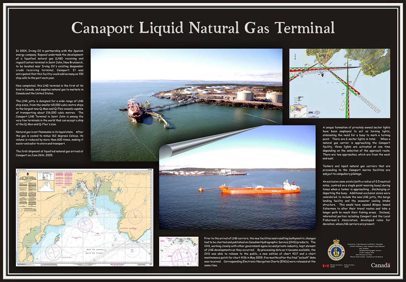
In 2004, Irving Oil in partnership with the Spanish energy company, Reposol undertook the development of a liquefied natural gas (LNG) receiving and regasification terminal in Saint John, New Brunswick, to be located near Irving Oil's existing deepwater crude receiving terminal, Canaport. It was anticipated that this facility could add as many as 100 ship calls to the port each year.
Now completed, this LNG terminal is the first of its kind in Canada, and supplies natural gas to markets in Canada and the United States.
The LNG jetty is designed for a wide range of LNG ship sizes, from the smaller 65,000 cubic metre ships to the largest new Q-Max and Q-Flex vessels capable of transporting about 216,000 cubic metres. The Canaport LNG Terminal in Saint John is among the very few terminals in the world that can accept a ship of the Q-Max and Q-Flex's size.
Natural gas is not flammable in its liquid state. After the gas is cooled to minus 162 degrees Celsius, its volume is reduced by more than 600 times, making it easier and safer to store and transport.
The first shipment of liquefied natural gas arrived at Canaport on June 26th, 2009.
A unique formation of privately owned sector lights have been employed to act as turning lights, eliminating the need for a buoy to mark a turning point. There are 6 sector lights in total. When a natural gas carrier is approaching the Canaport facility, three lights are activated at one time depending on the selection of the approach route. There are two approaches, which are from the west and east.
Tankers and liquid natural gas carriers that are proceeding to the Canaport marine facilities are subject to compulsory pilotage.
An exclusion zone exists (with a radius of 0.5 nautical miles, centred on a single point mooring buoy) during times when a tanker is approaching, discharging or departing the buoy. Additional exclusion zones were considered, to include the new LNG jetty, the barge landing facility and the seawater cooling intake structure. This would have caused Mispec based fishermen to alter their travel routes and take a longer path to reach their fishing areas. Instead, interested parties including Canaport and the Local Fisherman's Association, developed rules for deviation, when LNG carriers are present.
Prior to the arrival of LNG carriers, the new facilities and resulting bathymetric changes had to be charted and published on Canadian Hydrographic Service (CHS) products. The CHS, working closely with other government agencies and private industry, kept abreast of LNG developments as they occurred. By processing data as it became available, the CHS was able to release to the public, a new edition of chart 4117 and a chart maintenance patch for chart 4116 in May 2009, five months after the final "as built" data was received. Corresponding Electronic Navigation Charts (ENCs) were released at the same time.
- Date modified: