
2019 lobster fishery conservation harvesting plan for Lobster Fishing Area 25
Moncton, New Brunswick (NB) – July 11, 2019 – Fisheries and Oceans Canada (DFO), Gulf Region, announces the opening of the fishery and new management measures that will be in place in the Lobster Fishing Areas (LFA) 25 in 2019. Unless indicated otherwise, existing management measures remain in place. Please refer to your Lobster licence conditions for further details.
Opening Dates in 2019
Fisheries and Oceans Canada announced on July 22, 2019 that, at the request of the industry, the fishery in LFA 25 will open at 6:00 a.m. Thursday August 8, 2019, weather permitting. The last day of fishing will be October 9, 2019.
NEW management measure:
Daily-closed time (curfew)
Starting in 2019, there will be a daily close time from 9:00 p.m. to 4:00 a.m. in LFA 25 and this starting two days following the opening of the fishery and until two days prior to the closing day of the fishery, meaning that the fishing vessel shall not leave port to commence a lobster fishing trip prior to 4:00 a.m. and must terminate the fishing trip on the same day prior to 9:00 p.m.
Other Management Measures:
Logbooks and Electronic Logbooks (ELOGS)
Licence holders that will not be using ELOGS are required to use logbooks and submit them to DFO on a monthly basis as in previous years. The list of logbook suppliers is available here.
A separate notice on ELOGS is issued for your information (NEW starting in 2019). However please note that if you choose to use an ELOG in 2019, in case of ELOG malfunction, you will be required to submit a paper logbook, but ONLY for the duration of the malfunction. Licence holders using ELOG should therefore have a few paper logbooks onboard the vessel.
| - | Minimum legal carapace size (mm) | Window size females (mm) | Maximum number of traps | Minimum number of traps per line | Maximum hoop size (mm) |
|---|---|---|---|---|---|
| 25 | 77 | 115 | 240 PEI 250 NB 225 Gulf NS |
n/a | 152 |
Height and Length of Escape Mechanisms
The height of the escape mechanism as indicated in Table 2 needs to be adjusted according to the minimum legal carapace size in effect (77 mm).
| Length of escape opening between 127 mm and less than 254 mm | |
|---|---|
| Minimum legal carapace size | Height of escape opening |
| >76 mm | 44 mm |
| Length of escape opening equal to or greater than 254 mm | |
| Minimum legal carapace size | Height of escape opening |
| >76 mm to 80 mm | 43 mm |
| >80 mm | 44 mm |
Restrictions on the movement of Lobster licences
For information on restriction on the movement of Lobster Licences you can refer to the Commercial Fisheries Licensing Policy for Gulf Region.
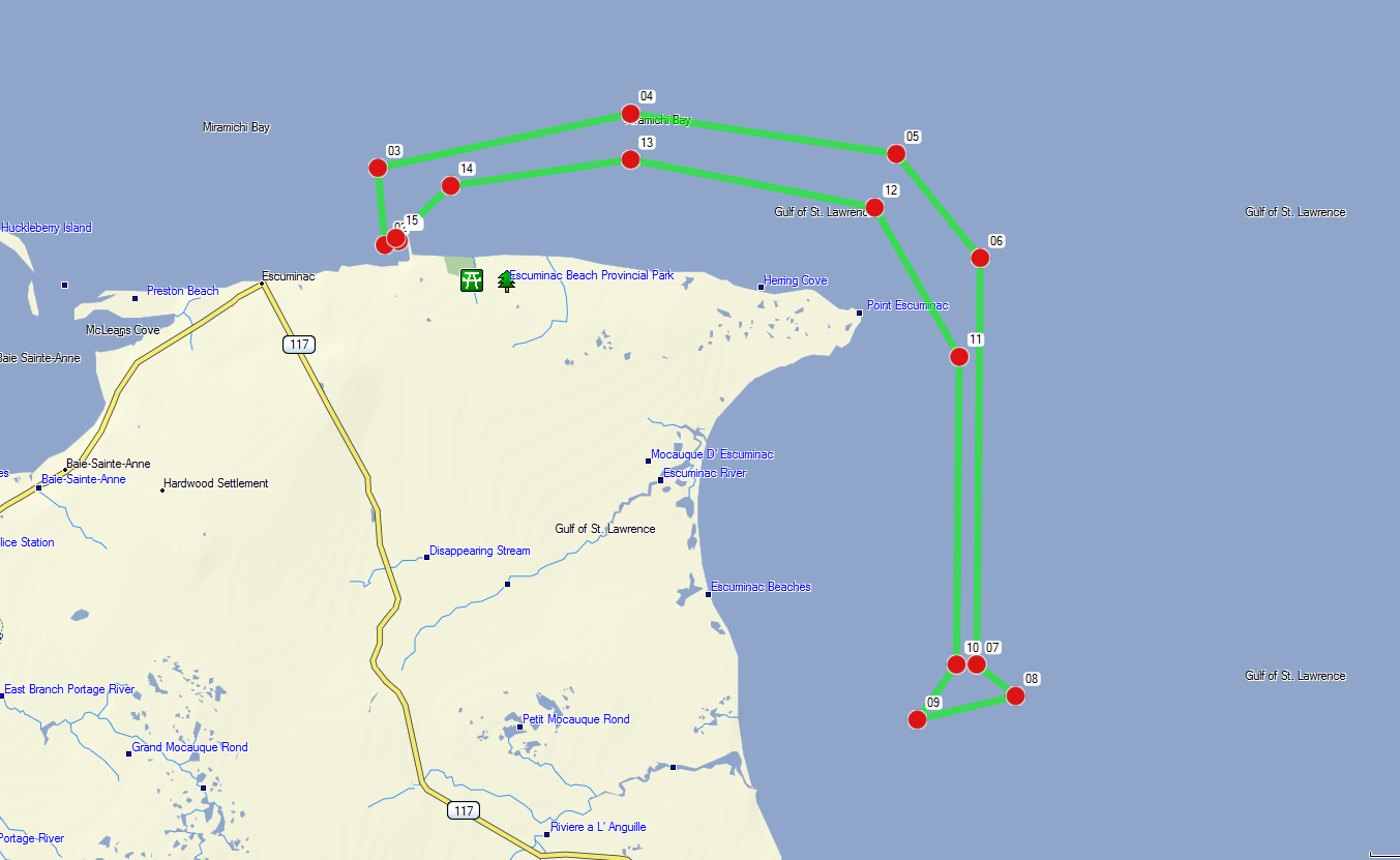
Transit Corridors
The transit corridors remain in effect and a Vessel Monitoring System (VMS) is required (every 5 minutes) if using the transit corridor. The opening of the transit corridor situated at the boundary line of LFA23/25 was expanded from 500 m to 1500 m (changing points 8 and 9 in the table below). The corridor allow fish harvesters to transport their catches through that area to reach their homeport avoiding the use of the smack boat. The coordinates for the corridor will be included in the Variation Order. The coordinates of the corridor and a map are also provided below for information purposes only.
The Transit Corridor is defined as the portion of the waters of LFA 23 enclosed by the rhumb lines (similar to a straight line plotted on a nautical chart) joining the following points in the order in which they are listed below. The coordinates are provided in NAD83 expressed in degrees, minutes and seconds as per the licence conditions (Column 1). They have been converted and provided in degrees, decimals, minutes for information purposes only (Column 2).
| Point | Degrees Minutes Seconds | Point | Degrees Decimal Minutes |
|---|---|---|---|
| 1 | N47 04’ 56.6’’ W64 53’ 14.1’’ | 1 | N47 04.943’ W64 53.235’ |
| 2 | N47 04’ 54.7’’ W64 53’ 23.8’’ | 2 | N47 04.912’ W64 53.397’ |
| 3 | N47 05’ 30.8’’ W64 53’ 28.7’’ | 3 | N47 05.514’ W64 53.479’ |
| 4 | N47 05’ 56.2’’ W64 50’ 30.5’’ | 4 | N47 05.937’ W64 50.508’ |
| 5 | N47 05’ 37.4’’ W64 47’ 23.1’’ | 5 | N47 05.623’ W64 47.385’ |
| 6 | N47 04’ 48.6’’ W64 46’ 24.0’’ | 6 | N47 04.810’ W64 46.399’ |
| 7 | N47 01’ 38.1’’ W64 46’ 26.5’’ | 7 | N47 01.635’ W64 46.441’ |
| 8 | N47° 01’ 23.3’’ W64° 45’ 9.0’’ | 8 | N47° 01.388’ W64° 45.983’ |
| 9 | N47° 01’ 12.2’’ W64° 47’ 8.3’’ | 9 | N47° 01.203’ W64° 47.138’ |
| 10 | N47 01’ 38.1’’ W64 46’ 40.7’’ | 10 | N47 01.634’ W64 46.678’ |
| 11 | N47 04’ 02.3’’ W64 46’ 38.7’’ | 11 | N47 04.038’ W64 46.645’ |
| 12 | N47 05’ 12.2’’ W64 47’ 38.3’’ | 12 | N47 05.204’ W64 47.639’ |
| 13 | N47 05’ 34.7’’ W64 50’ 30.5’’ | 13 | N47 05.579’ W64 50.508’ |
| 14 | N47 05’ 22.5’’ W64 52’ 37.4’’ | 14 | N47 05.374’ W64 52.623’ |
| 15 | N47 04’ 58.0’’ W64 53’ 16.0’’ | 15 | N47 04.967’ W64 53.267’ |
Note: Fish harvesters must ensure to use the proper Latitude/Longitude format when entering the coordinates in their GPS plotter.
Management measures for the protection of the North Atlantic Right Whales
Please refer to the separate notice issued on this subject.
Before you go fishing
The Department has assembled a list of requirements and documents harvesters will need before they start fishing.
For more information:
Sandra Comeau
Resource Management, Eastern NB
Fisheries and Oceans Canada
Tracadie, NB
(506) 395-7765
Sandra.Comeau@dfo-mpo.gc.ca
Ben Moore
Resource Management, PEI
Fisheries and Oceans Canada
Charlottetown, PEI
(902) 370-7094
Benjamin.Moore@dfo-mpo.gc.ca
Alan Dwyer
Resource Management, Gulf NS
Fisheries and Oceans Canada
Antigonish, NS
(902) 735-7114
Alan.Dwyer@dfo-mpo.gc.ca
Josiane Massiéra
Resource Management, Gulf Region
Fisheries and Oceans Canada, Gulf Region
Moncton, NB
(506) 851-7290
Josiane.Massiera@dfo-mpo.gc.ca
- Date modified: