Mamalilikulla First Nation Guardian
The Mamalilikulla (Mama-lee-lee-kalla) First Nation and Fisheries and Oceans Canada (DFO) are working together. We protect a unique and fragile marine ecosystem in Knight Inlet, British Columbia (BC).
About the Guardians
The Mamalilikulla First Nation are traditional stewards of the area that has recently been established as the Gwa̲xdlala/Nala̲xdlala (Lull/Hoeya) marine refuge in Knight Inlet. The Mamalilikulla First Nation Guardians are now trained to help implement DFO's policies and procedures, but are guided first and foremost by their nation's ancient law of Aweenak'ola.
"When we say Aweenak'ola, we mean we are one with the land, the sea, the sky and the supernatural Ones," says Mamalilikulla Chief Councillor Winidi (John Powell). "The creatures of the water, the land, the sea and the sky and the heavens… all of those creatures, we have to nourish them. We have a duty to protect them; we have to make certain that we manage our territory so that it is conducive to housing them."
In recognition of the inlet's rare species, high biodiversity and cultural significance, the Mamalilikulla First Nation worked in close collaboration with the Province of BC and the Government of Canada to protect the area. The animals protected in the Gwa̲xdlala/Nala̲xdlala (Lull/Hoeya) marine refuge are part of a diverse marine community. There are about 240 aquatic species, including 46 rare and fragile:
- cold-water corals
- sponges
- anemones

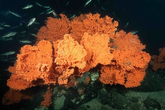
A massive grouping of Primnoa coral fans (approximately 1.50 m wide x 1.2 m high) flanked by a school of Yellowtail Rockfish. © Pauline Ridings, 2023
They live on the Hoeya Sill. This underwater ridge provides the unique aquatic conditions to host massive, tree-like Gorgonian corals. These corals provide habitat where countless other species can thrive.
The marine refuge is also home to important eelgrass and kelp beds, and 2 important intertidal estuaries. These estuaries play a vital role in the health of the ocean ecosystem. They support rare and endangered birds and culturally important grizzly bears.
The Hoeya Sill in the marine refuge is particularly remarkable because of the rising of deeper currents over the ridge. This allows species, normally restricted to deeper depths, to thrive at only 12 metres below the surface. The shallow waters make the ecosystem ideal for scientific study but also extremely susceptible to damage from bottom-contact fishing activities common in the area. This is especially true for fragile and slow-growing species, such as Gorgonian corals.
The marine refuge also includes significant inter-tidal archaeological features. These features:
- reflect its long occupation as a Mamalilikulla origin area
- include stone fish traps and weirs, and canoe runs associated with 3 ancient village sites
Path to protection
The Mamalilikulla territory supported a large population before European contact but declined to about 2,000 people in the 1840s to 1850s. A small number of Mamalilikulla still lived at Gwa̲xdlala/Nala̲xdlala in 1914. In that year, the McKenna-McBride Commission was set up to consider additional land reserves and it turned down the Mamalilikulla's proposals for reserves in Gwa̲xdlala/Nala̲xdlala.
As a result, the existing 400 registered members of the Mamalilikulla First Nation have not had direct connection to, nor resided in, their ancestral territory since the 1920s. However, recognizing the declining health of ecosystems in its territory, and in keeping with the law of Aweenak'ola, the Mamalilikulla founded a Guardian program in order to resume its presence and stewardship role.
With the advent of new international commitments to marine and land protection targets by Canada, and with the unique ecosystems and cultural sites in peril, the Nation publicly declared the area an Indigenous Protected and Conserved Area (IPCA) on November 29, 2021.
DFO had already been aware of ongoing evidence of damage to the Hoeya Sill from multiple types of fishing gear. The Canadian Science Advisory Secretariat and various Environmental Non-Governmental Organizations had documented the biodiversity of the site and Mamalilikulla and DFO had also proposed that the Hoeya Sill area be included in a new regional marine protected area network.
In 2022, further discussions expanded the proposal to incorporate Mamalilikulla's cultural conservation interests and more concrete action for protection.
In February 2023, during the Fifth International Marine Protected Areas Congress (IMPAC5), this collaborative work culminated in the Government of Canada, Mamalilikulla First Nation and Province of BC announcement of a new marine refuge over the marine portion of the Mamalilikulla IPCA and a related fisheries closure to protect the site's significant ecosystems.
The announcement represented the first site designation from those proposed by a new marine protected area network in the Northern Shelf Bioregion, being collaboratively developed and implemented by First Nations, the Province of BC and Canada.
The Gwa̲xdlala/Nala̲xdlala (Lull/Hoeya) marine refuge site, which is 21.4 km2 (8.3 sq. mi), contributes towards Canada's total marine conservation goals of conserving 25% of marine and coastal areas by 2025 and 30% by 2030.

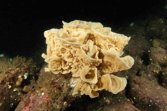
One of the deep water sponge species found in the shallow waters of the Hoeya Sill. © Pauline Ridings, 2016
The Northern Shelf Bioregion is highly productive, and has unique ecological, oceanographic and seabed characteristics. The bioregion covers approximately 2/3 of the coast of BC, extending from the top of Vancouver Island, including Quadra Island and Bute Inlet, to the Canada–United States border at Alaska. Marine refuges are fisheries management measures, including closures under the Fisheries Act, that qualify as Other Effective Area-Based Conservation Measures (OECMs).
These protection measures provide benefits for biodiversity and are intended to be in place for the long-term. They make a lasting contribution to marine conservation.
A marine protected area network is a collection of individually protected sites that, taken together, protect biodiversity and important ecological features in the ocean.
"The establishment of the Gwa̲xdlala/Nala̲xdlala (Lull/Hoeya) marine refuge signified a key moment in providing protection and conservation to a very important ecosystem in our ocean. It also represents the collaboration that is required for true conservation," says Heather Brekke, Regional Manager, Marine Conservation, DFO.
Collaboration and capacity building
Through the support of DFO's Oceans Management Contribution Program, collaboration in the Gwa̲xdlala/Nala̲xdlala marine refuge is ongoing and includes:
- monitoring and stewardship activities
- development of a management plan
This project will continue to contribute to capacity and knowledge building by the Mamalilikulla First Nation and DFO.
The project provides funding and training to Mamalilikulla First Nation Guardians who monitor the refuge. They look for any marine activity that could damage the sensitive underwater ecosystems. In this way, the project improves onsite monitoring capacity at this remote location.

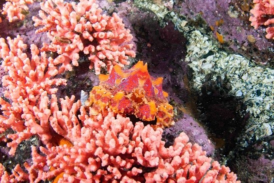
A colourful juvenile Puget Sound King Crab resting on Pink Branching Hydrocoral, rare and not usually found in shallow waters. © Pauline Ridings, 2021
It also provides the Mamalilikulla First Nation with the resources to manage and participate in underwater dive surveys of the Hoeya Sill. These surveys foster a better understanding of the area's unique biodiversity, such as the varieties of corals, sponges and aquatic species living there, and how they are changing over time.
The data gathered through the dive surveys will also help identify sensitive areas and support the development of the refuge's management plan.
"This project is an opportunity to understand and support the government's regulations, standards and guidelines around marine protection. Under our ancient law of Aweenak'ola, we do not separate those things out, but working hand in hand with partners like DFO gives us the opportunity to learn about specific western methodologies while still practicing our own stewardship in the areas," says Chief Councillor Winidi. "... it means that we have some control over the environment and that the beings that live in it are going to be able to thrive in the future. This area is also a very significant origin area for our people, and we have a long history there that we want to reconnect with. It means that someday we can come back here and enjoy it in the same way our ancestors did."
- Date modified:
