
Basin Head Marine Protected Area Operational Management Plan 2021 to 2026
Acknowledgements
The operational management plan for the Basin Head marine protected area (MPA) was prepared by the Marine Planning and Conservation Program, Fisheries and Oceans Canada (DFO), Gulf Region, with the assistance from the Basin Head Advisory Committee (BHAC).
Contact information
General informationMPC Program
DFO
343 University Avenue, PO Box 5030
Moncton, New Brunswick, E1C 9B6
Email: oceans-glf@dfo-mpo.gc.ca Conservation and Protection – enforcement
DFO
Tel: 902-687-2019 Marine Accidents, Spills and Environmental Emergencies
Canadian Coast Guard/Environment and Climate Change Canada
Tel: 1-800-565-1633 Oil, pesticide and chemical spills, air quality problems or fish kills
PEI Department of Environment, Energy and Climate Action
Tel: 1-902-368-5700 (working hours), 1-800-565-1633 (24 hours), or depteeca@gov.pe.ca
Published by:
MPC Program, Gulf RegionDFO
Moncton, New Brunswick
E1C 9B6
© Her Majesty the Queen in Right of Canada, 2022
Catalogue number: Fs146-2/2021-E-PDF
ISBN 978-0-660-40431-8
Foreword
Basin Head was designated as a MPA under the Oceans Act on September 26, 2005, to conserve and protect a unique strain of Irish moss (Chondrus crispus), also known as the giant Irish moss, which is thought to exist only within the confines of Basin Head. The designation of the Basin Head MPA was the result of successful culmination of several years' work by the Basin Head lagoon ecosystem conservation committee which included representatives from various stakeholder groups (landowners, local economic interests, DFO and the former Prince Edward Island (PEI) Department of Environment, Energy and Forestry). In 2009, the DFO developed its first management plan and moving from a planning phase to management phase, the Basin Head lagoon ecosystem conservation committee was renamed the BHAC.
The BHAC continues to provide advice to the DFO regarding the management of the MPA, and assists in ecological monitoring and enforcement monitoring within the MPA. The committee also takes an important role in many of the management actions associated with the non-regulatory objectives, such as coordinating education and awareness programs and promoting this MPA to tourists and local community. Members of the BHAC also explore ways in which the MPA can create benefits in employment and learning opportunities and seek funding opportunities and partnership to support the MPA management.
This version of the Basin Head MPA operational management plan is an update to the previous 2014 version (DFO 2016), and it describes management strategies and actions for the next 5 years (2021-2026). This version also provides updated monitoring activities based on the 2019 science advisory process which assessed the monitoring activities undertaken in Basin Head over the last decade to determine their effectiveness and provide recommendations to improve the monitoring (DFO 2020). The operational management plan was developed in collaboration with the advisory committee, using results of the monitoring programs and research activities, science advice and input from key provincial departments. The BHAC is satisfied that the aims and objectives of the Basin Head MPA will be well served by this plan and fully support it.
Approved by:
Keila Miller, France Braceland
Co-chair, BHAC, Co-Watershed Coordinators, Souris and Area Branch of the PEI Wildlife Federation (SAB)
Carole Godin
Manager, Marine Planning and Conservation, DFO
Table of contents
- List of figures
- List of tables
- List of acronyms
- 1.0 Introduction
- 2.0 Background
- 3.0 Managing the Basin Head MPA
- 4.0 Governance
- 5.0 References
- Appendix 1: Basin Head Marine Protected Area Regulations
- Appendix 2: BHAC Committee members
List of figures
- Figure 1. Location of Basin Head PEI.
- Figure 2. Management framework for the Basin Head MPA.
- Figure 3. Basin Head MPA zonation.
- Figure 4: The morphology of the coastal Irish moss (a) and the unique broad morphology of the Irish moss plant found only in Basin Head, eastern PEI (b).
- Figure 5. Estimated increase in giant Irish moss coverage (m2) in Northeast Arm, 2013-2020, resulting from restoration work that was initiated in 2015.
- Figure 6. Location of Irish moss beds in Basin Head MPA.
- Figure 7. Protected natural areas in and around the Basin Head watershed and land managed by the PEI Department of Environment, Energy and Climate Action (Forest, Fish and Wildlife Division).
- Figure 8. Male (upper panel) and female (lower panel) yearly carapace width size distribution.
- Figure 9. Delineation of the Basin Head MPA boundaries.
List of tables
- Table 1: Overview of the key management priorities and high level management action for Basin Head MPA. For detailed site management activities see Tables 2 and 3.
- Table 2: Management strategies, ecological monitoring activities, and current and proposed management actions, including recognized thresholds (when available) and triggers for additional management action relevant to each regulatory conservation objective. Note: thresholds, triggers and management actions were only identified for the short term goals (5 years).
- Table 3: Basin Head MPA non-regulatory conservation objectives and management actions with associated short (5 years) and long term (10 years) goals.
List of acronyms
- BHAC
- Basin Head Advisory Committee
- BMP
- Beneficial Management Practices
- CO
- Conservation objective
- CPUE
- Catch per unit effort
- DFO
- Fisheries and Oceans Canada
- MPA
- Marine protected area
- MPC
- Marine Planning and Conservation
- PEI
- Prince Edward Island
- SAB
- Souris and Area Branch of the PEI Wildlife Federation
1.0 Introduction
Basin Head is located near the eastern tip of PEI approximately 100 km east of Charlottetown, between the town of Souris and the community of East Point (Figure 1). Basin Head is a small estuarine lagoon surrounded by agricultural land to the north and by an extensive sand dune system to the south protected under provincial regulation. The Basin Head ecosystem is inhabited by a rich diversity of organisms including marine plants, invertebrates, fish, mammals and birds. Most notable to the area is a distinct strain of Irish moss (Chondrus crispus), a marine alga also known as the giant Irish moss, which has a life cycle adaptation to the natural habitat that has not been documented anywhere else for this species. The distinctive characteristics of the Basin Head Irish moss include the complete dependence on fragmentation for dispersal and multiplication; the dependence on Blue mussels for substrate attachment; the large frond size and distinctive morphology; its unusually high carrageenan content and sustained dark red pigmentation throughout the year.
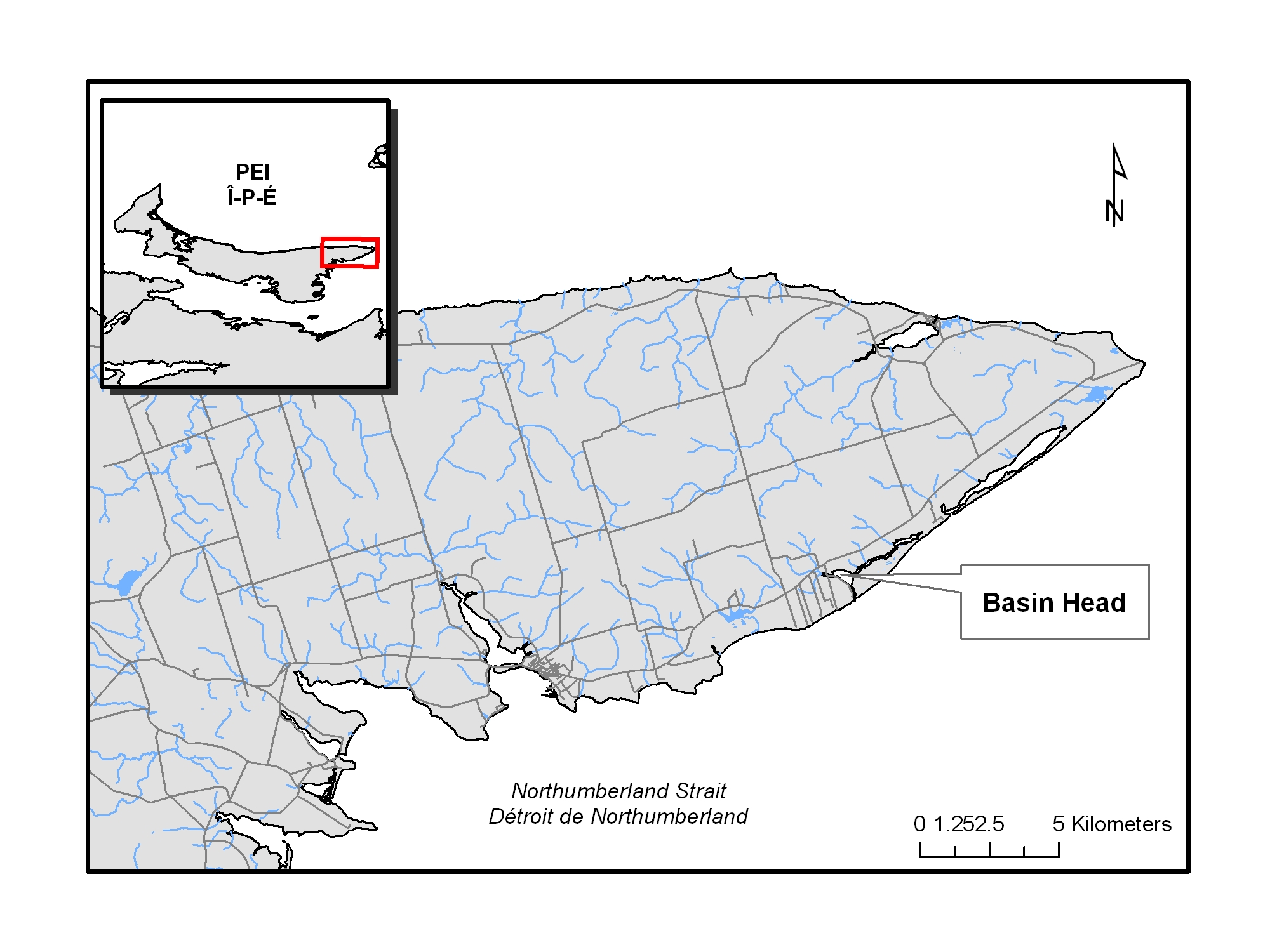
Figure 1. Location of Basin Head PEI
The Basin Head MPA has been established under the statutory authority of the Oceans Act. The rationale and purpose of the MPA is the protection and conservation of the distinct strain of Irish moss and its habitat. The MPA designation of Basin Head in September 2005 represented the successful culmination of several years' work by the Basin Head Lagoon Ecosystem Conservation Committee and DFO. After MPA designation, the BHAC was created to provide advice and recommendations to DFO on the management and monitoring of the Basin Head MPA. The committee includes representatives from DFO, provincial government departments of PEI, the Mi'kmaq Confederacy of PEI, Rural Municipality of Eastern Kings, conservation groups, academia and the fishing and agriculture industries.
An overview of the conservation initiatives and consultations that ultimately led to the designation of the Basin Head MPA is provided in previous versions of the management plan (DFO 2009a, DFO 2016).
1.1 Purpose and scope
The purpose of this operational management plan is to guide DFO, the BHAC, provincial regulatory authorities and other stakeholders in managing the various human activities within and surrounding the MPA. The management plan describes:
- management zones
- regulations that apply within the MPA
- conservation objectives (COs)
- permitted activities within the boundaries
- ecological monitoring activities and management actions for each regulatory and non-regulatory conservation objective (CO), and related legislation and
- governance structure
The plan also describes how the MPA is to be managed for the short (5 years) and long-term (10 years) and how the state of the MPA will be measured and reported; and allows for necessary management actions. By clearly establishing roles and responsibilities and ensuring appropriate planning and reporting loops that incorporate an adaptive management approach, it will be possible to determine whether, or to what extent, management actions have achieved the COs. Furthermore, this plan identifies thresholds of harm (when available), describes current and proposed management actions, and establishes triggers for additional actions including climate change adaptations. All monitoring and management actions will incorporate collaborative and community-based approaches.
This version of the Basin Head MPA operational management plan is an update from the 2014 version (DFO 2016) which is the 3rd edition of this plan. This is a “living” plan, with its review scheduled every 5 years; however, it may be amended at any time upon the advice of the advisory committee, based on results of the scientific and monitoring programs.
1.2 Management framework
As an operational tool, the management plan is not intended to be prescriptive; rather, it establishes management standards to assist all stakeholders in meeting the MPA objectives. Figure 2 describes, in broad terms, the management framework for the Basin Head MPA.
The collective expertise, knowledge and mandates of DFO, other federal and provincial government departments and the advisory committee provide the basis for a governance structure responsible for management of the MPA. The management plan sets priorities and actions, in order to measure the progress of the MPA towards its objectives.
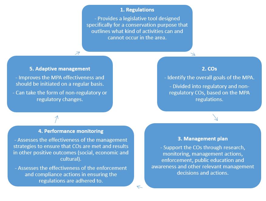
Figure 2. Management framework for the Basin Head MPA.
Long description
The management framework contains 5 steps and aims to establish management standards to assist all stakeholders in meeting the MPA objectives.
- Regulations
- provides a legislative tool designed specifically for a conservation purpose that outlines what kind of activities can and cannot occur in the area
- COs
- identify the overall goals of the MPA
- divided into regulatory and non-regulatory COs, based on the MPA regulations
- Management plan
- support the COs through research, monitoring, management actions, enforcement, public education and awareness and other relevant management decisions and actions
- Performance monitoring
- assesses the effectiveness of the management strategies to ensure that COs are met and results in other positive outcomes (social, economic and cultural)
- assesses the effectiveness of the enforcement and compliance actions in ensuring the regulations are adhered to
- Adaptive management
- improves the MPA effectiveness and should be initiated on a regular basis
- can take the form of non-regulatory or regulatory changes
2.0 Background
2.1 Basin Head lagoon ecosystem
The Basin Head MPA covers an area of 9 km2, which includes 3 distinctive areas: the outer coast (zone 3), the main basin (zone 2) and the inner channel (zone 1) (figure 3). The Basin Head ecosystem is shallow, with an overall average depth of less than 1 m above chart datum (Sharp et al. 2003). The deeper basin is about 500 m in diameter and is attached to a shallower channel (Northeast Arm) that is about 3 km long and up to 200 m wide. The distinct strain of Irish moss is found only on relatively firm, sandy substrates within this channel. Sandy substrates are primarily found on shallow banks in the center of the channel whereas muddy sediments often cover the intertidal fringes and deeper channels. The mouth of the lagoon and the first 100 m of the entrance channel are highly energetic, with average tidal current speeds reaching 50 cm/s, while in Northeast Arm, average current speeds rarely exceed 16 cm/s.
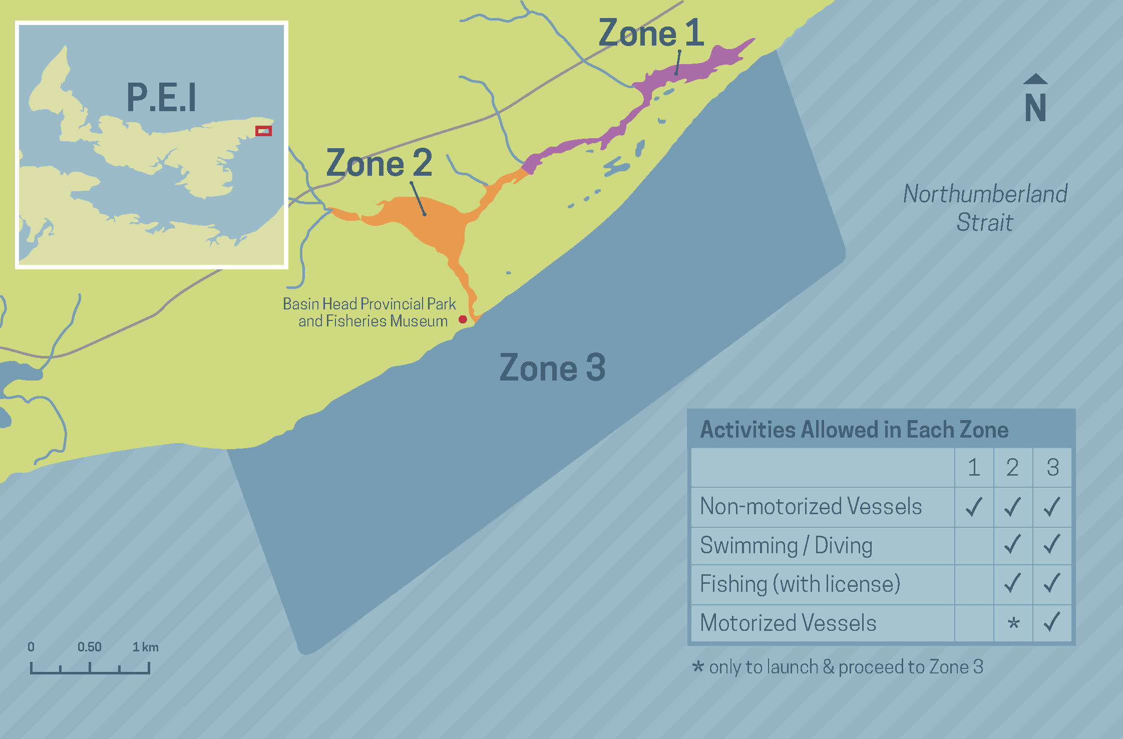
Figure 3. Basin Head MPA zonation.
Long description
The Basin Head MPA covers an area of 9 km2, which includes 3 distinctive areas: the outer coast (zone 3) shown in solid blue shading, the main basin (zone 2) shown in solid orange shading, and the inner channel (zone 1) shown in solid purple shading.
Activities allowed in each zone include:
- operation of motorized vessels is permitted in zone 3 only, with the exception to launch and proceed to zone 3 permissible to occur in zone 2
- licensed fishing, swimming/diving, and the use of non-motorized vessels are all permitted within zones 2 and 3
- use of non-motorized vessels is permitted within zone 1; licensed fishing, swimming/diving, and the use of motorized vessels are not allowed
In 1976, a distinct strain of Irish moss was identified in Basin Head (Judson et al. 1987) which differs from the outer coastal forms that are attached to hard substrates (e.g. rocks, concrete) by holdfasts. In order to understand the Basin Head ecosystem and this distinct strain, marine plant research scientists have been gathering data on the biological and physical characteristics of the lagoon since 1979 (McCurdy, 1979; McCurdy, 1980; Sharp et al., 2003). Irish moss normally has a life cycle with 3 phases:
- gametophytes (male and female); and
- 2 spore-producing phases
- parasitic carposporophytes
- free-living tetrasporophytes
The primary mode of reproduction is by the sexual production of gametes and spores that form small plants, which attach to a hard substrate. The second and usually minor process is vegetative reproduction by fragmentation which is the only mode employed by the giant Irish moss (Sharp et al. 2003; Tummon Flynn et al. 2008). Called “giant Irish moss” because it is significantly larger and more fleshy than outer coastal forms (Figure 4), the Basin Head plant is not attached to the bottom by a holdfast but instead is held in place by Blue mussels. The mussels attach themselves to fragments of giant Irish moss using the byssal threads that they usually employ to attach themselves to hard substrates or objects. Irish moss-mussel clumps are found only in the Northeast Arm zone 1 (figure 3), behind the dune complex.
Field observations in 1999 detected a decline in abundance of this distinctive seaweed in Basin Head relative to the recorded abundance in 1980. Subsequent annual monitoring revealed that the bottom area covered by Irish moss declined from an estimated 15,000 m2 in 1980 to less than 2,000 m2 in 2005. As of 2013, the population had declined to less than 1% of its historic biomass, an estimated 2 m2, but because of restoration efforts starting in 2015, giant Irish moss cover increased to approximately 184 m2 by the end of 2020 (figure 5). New beds have also been discovered outside the main Irish moss bed (figure 6). Increased monitoring effort in 2014 enabled us to find a new Irish moss-mussel clumps bed further up the Northeast Arm, at the site called Corduroy rd., (DFO 2015) and further down the Northeast Arm, at a site called Fireweed bank. There are presently 3 Irish moss beds in Basin Head that are surviving and that are being restored yearly.
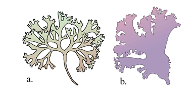
Figure 4: The morphology of the coastal Irish moss (a) and the unique broad morphology of the Irish moss plant found only in Basin Head, eastern PEI (b).
Long description
Panel (a) is an image of coastal Irish moss, which shows narrow, green fronds (leaves). Panel (b) is an image of the Irish moss unique to Basin Head, PEI, which shows broader, expanded fronds (leaves) that sustain a seasonal coloration of deep purple.
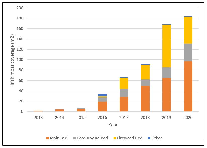
Figure 5. Estimated increase in giant Irish moss coverage (m2) in Northeast Arm, 2013-2020, resulting from restoration work that was initiated in 2015.
Long description
Bar graph describing the giant Irish moss coverage (m2) for each bed in the Northeast Arm from 2013-2020.
Color legend:
- Dark orange: Main bed
- Grey: Corduroy road bed
- Light orange: Fireweed bed
- Blue: Other areas
| Bed name | 2013 | 2014 | 2015 | 2016 | 2017 | 2018 | 2019 | 2020 |
|---|---|---|---|---|---|---|---|---|
| Main bed | 1.9 | 4.2 | 4.5 | 18.9 | 28.2 | 49.5 | 64.8 | 96.6 |
| Corduroy rd bed | na | 1 | 1.9 | 8.6 | 15.5 | 12.9 | 20.4 | 34.5 |
| Fireweed bed | na | na | 0 | 1.7 | 21 | 27.6 | 82.4 | 51.4 |
| Other | na | 0 | 0 | 4.7 | 1.3 | 1 | 1 | 1 |
| Total | 1.9 | 5.2 | 6.4 | 33.9 | 66 | 91 | 169 | 184 |
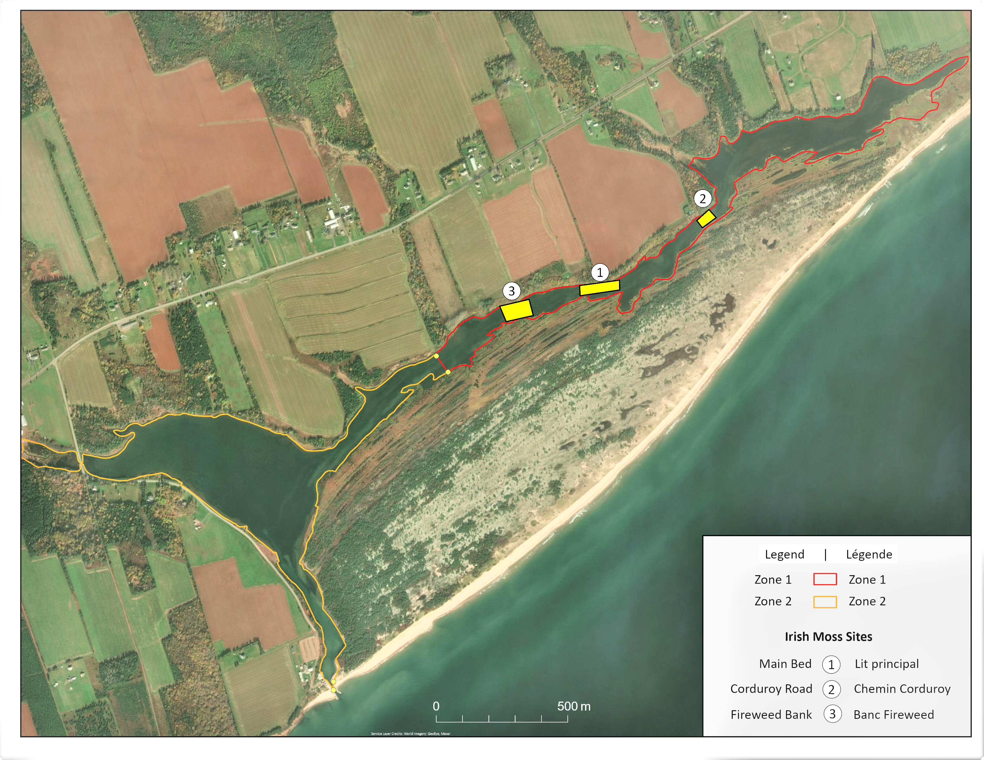
Figure 6. Location of Irish moss beds in Basin Head MPA.
Estuaries and associated salt marsh communities play an important role in the functioning and integrity of the coastal waters of PEI. Estuaries are partially enclosed coastal bodies of water where ocean water and freshwater mix. Salt marshes are characterized by salt-tolerant grasses, with an extensive shallow rhizome (root) system that can trap and stabilize mobile sediments. Estuaries rank as one of the most productive ecosystems on earth, and marshes are referred to as the life-support system because of their vital functions. Estuarine lagoons with single narrow opening to the sea, such as Basin Head, have restricted flushing and are more vulnerable than open-mouthed estuaries to shallowing caused by sedimentation.
The Basin Head lagoon watershed is relatively small (approximately 17.5 km2, including the sand dune), with several streams entering the north face of the lagoon. The south side of the lagoon is bordered by a sand dune system (3.2 km2) measuring between 0.5 and 1 km in width. The Basin Head sand dune system consists of extensive dunes including old beach ridges covered with lichens and 5 native plant communities:
- marram grass (Ammophila breviligulata)
- heath (Corema Conradii-Cladonia spp)
- black spruce (Picea mariana)
- cranberry (Vaccinium macrocarpon)
- salt marsh (Spartina patens – Carex palaecea)
The Basin Head area is one of the best examples of geological formation and vegetational dune succession on PEI. Between 1995 and 2013, 1.91 km2 of the sand dunes surrounding Basin Head were protected and are managed under the provincial statutory authority of the PEI Natural Areas Protection Act (figure 7). The act is designed to protect the feature by controlling activities and restricting development. Within natural areas, human disturbance is discouraged, and natural succession of the sand dune and wetland communities is desired. Educational and recreational activities are permissible within this natural area. The large dune complex is fronted, on the ocean side, by an extensive beach (locally known as Singing Sands). The Northumberland Strait bottom adjacent to the beach is shallow and sandy.
The Basin Head MPA and Sand Dune natural protected area have 2 distinct COs; the former is to protect a single species and its habitat and the latter the natural succession of the sand dune and wetland. These 2 objectives can sometimes be conflicting as some measures to protect a conservation priority (e.g., saltmarsh restoration to reduce impacts of erosion on Irish moss beds) might not be aligned with other conservation principles (e.g., leave the marsh to evolve as a natural system). The BHAC will strive to maintain a balance between species and ecosystem conservation and work to manage both systems collaboratively.
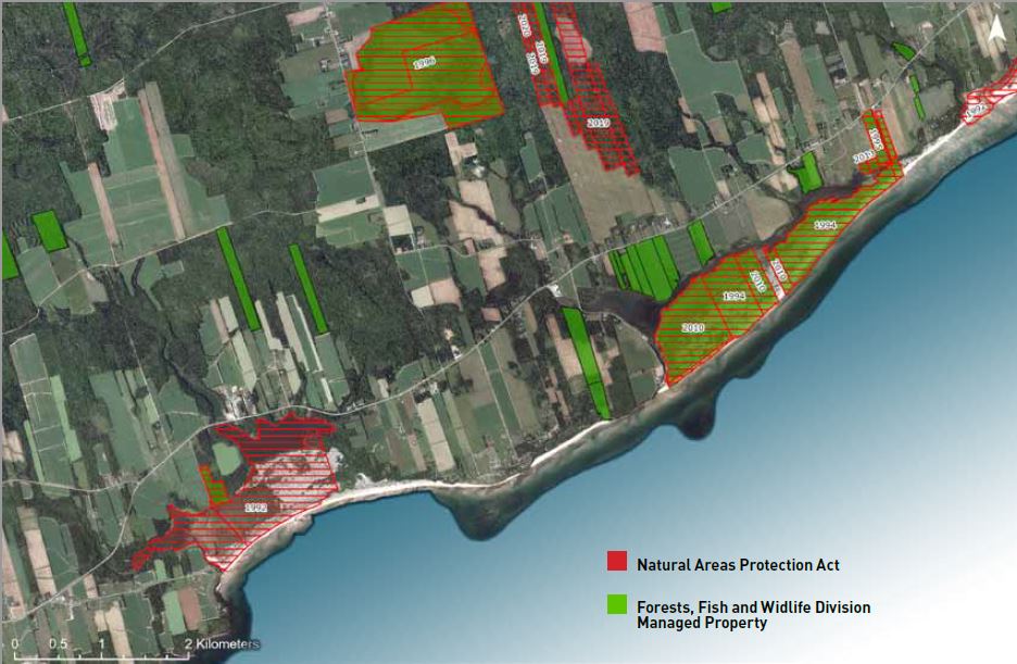
Figure 7. Protected natural areas in and around the Basin Head watershed and land managed by the PEI Department of Environment, Energy and Climate Action (Forest, Fish and Wildlife Division).
Long description
Areas protected under the PEI Natural Areas Protection Act in the Basin Head watershed area shown in red thatched shading, and lands managed by the PEI Department of Environment, Energy and Climate Action (Forest, Fish and Wildlife Division) are shown in opaque green shading. The year of their designation is shown directly on the parcel of land.
2.2 Community and economic values
Land use in the Basin Head watershed is primarily agricultural at 53% (8 km2) dominated by potato farming and forested at 31.5% - (4.77 km2) with limited residential and commercial development at 11% (1.60 km2). These land use data were provided by the PEI Department of Environment, Energy and Climate Action; and were derived from the aerial survey that was completed in 2010.
The area surrounding the Basin Head lagoon is best characterized as rural farming lands. The local economy has a strong association with renewable natural resource harvesting (fisheries) and agriculture. A provincial fisheries museum, a provincial park and a provincial campground are adjacent to the MPA. The Singing Sands beach at the foreshore of the area draws visitors from within and outside of PEI, making Basin Head MPA one the of the most visited MPAs in Canada. Basin Head beach currently attracts upwards of 75,000 visitors a year, while the Basin Head Fisheries Museum receives approximately between 20,000 to 25,000 visitors yearly, plus children and school trips. An audit of human use of the area is available in the document titled Community Use of the Basin Head Lagoon, PEI (Island Nature Trust 2001) prepared for the Basin Head lagoon ecosystem conservation committee by the Island Nature Trust. No major changes are known to have occurred in land use since that publication.
2.3 Overview of MPA regulations
Section 35(3) of the Oceans Act provides for the development of regulations that allow MPAs to be designated, zoned, and activities or classes of activities to be prohibited. The Basin Head regulations were developed through a consensus-based process involving the public, stakeholder groups, provincial partners and indigenous groups. A series of consultations conducted over a period of 7 years (1999 to 2005) resulted in the designation of the Basin Head MPA under the Oceans Act and the creation of the Basin Head Marine Protected Area Regulations (appendix 1). For more details on the history of Basin Head designation and consultation process please refer to earlier versions of the operational management plan (DFO 2009a, DFO 2016).
2.3.1 Management zones
The Basin Head MPA includes 3 management zones (figure 3).
The inner channel (zone 1) – This zone extends from the main basin eastward for approximately 3 km to the eastern limit of the ecosystem. Zone 1 has the highest level of protection given that it encompasses the only habitat occupied by giant Irish moss within this ecosystem.
The lagoon (zone 2) – This zone encompasses the west end of the inner channel, the main basin and the entrance channel of the lagoon. It acts as a buffer zone for the more sensitive zone 1.
The outer coastal zone (zone 3) – This zone, extending from the mouth of the lagoon to 1 nautical mile seaward and 3 nautical miles from east to west, is a buffer to protect the integrity of the dune structure.
2.3.2 The regulatory intent
The health of Basin Head lagoon is linked to surrounding marine waters and its continued existence depends on the stability of the sand dune system. Each zone of the MPA has a different suite of physical environments or habitats and therefore requires a different management approach. In order to conserve and protect the marine resources of the Basin Head MPA and their habitats, specific activities are prohibited in each zone. The Basin Head Marine Protected Area Regulations contain a general prohibition against the disturbance, damage, destruction or removal of any living marine organism or any part of its habitat within the MPA. In addition, the regulations prohibit activities, including depositing, discharging or dumping of substances within the MPA that are likely to result in the disturbance, damage, destruction or removal of any living marine organism or any part of its habitat within the MPA.
Furthermore, the regulations recognize that certain activities, such as scientific research and specific types of fishing, may be allowed to occur within the MPA under specific conditions, as long as they do not compromise the COs. Moreover, other activities such as monitoring are required to support the management and protection of the MPA, while other activities related to public safety and security will always be allowed and may require specific permitting.
Within the regulations, activities are managed through (1) the submission and approval of activity plans for scientific and educational activities that comply with specified conditions, and (2) specific exceptions to the general prohibitions according to specified conditions. Scientific research and educational activities may be approved throughout the entire MPA. A plan for these activities must be submitted, specific information listed in the regulations must be supplied about the activity, and the activity must not damage or destroy the habitat of living marine organisms within the MPA. For activity application for Basin Head MPA please refer to the Basin Head MPA website.
In zone 1, the minister may only approve plans for scientific activities for the purposes of managing the MPA or monitoring the effectiveness of the conservation measures. The minister may approve plans for educational activities in zone 1 for the purposes of increasing awareness of the MPA, or providing information respecting the conservation measures implemented in the MPA. In zone 2 and zone 3 scientific and educational activities can occur provided they do not damage or destroy the habitat of living marine organisms. The cumulative environmental effects of these activities, in combination with all other past and current activities, will also be considered prior to ministerial approval to ensure that the activities are not likely to cumulatively result in damage or destruction of any MPA feature or the Irish moss it is designed to protect.
2.3.3 Activities within the MPA
Throughout the MPA, specific exceptions to the general prohibitions will be permitted for the purpose of public safety, law enforcement, national defense, national security or emergency response to ensure the safety of Canadians. Aboriginal Peoples fishing in accordance with the Aboriginal Communal Fishing Licenses Regulations will also be permitted throughout the MPA.
Zone 1 (the inner channel) – Activities permitted in this area are limited to those which do not disturb, damage or destroy or remove living marine organisms or their habitat or deposit, discharge or dump harmful substances. Because of the vulnerability of the Irish moss in this zone, activities such as swimming, scuba diving, the use of motorized vessels and fishing are not permitted.
Zone 2 (the lagoon) – This zone will tolerate some disturbances such as swimming and diving. Non-motorized vessel based recreational and commercial fishing will be permitted in this zone if these activities are carried out in accordance with the Atlantic Fishery Regulations, 1985, Maritime Provinces Fishery Regulations or the PEI's Wildlife Conservation Act. The use of a motorized vessel will only be permitted in this zone in order to launch or land a vessel at a boat launch and proceed to zone 3. The maintenance, repair, or removal of a bridge or boat launch will also be permitted in this zone if the applicable authorizations for these activities have been obtained under the Navigation Protection Act or the Fisheries Act. Requirements under this legislation are considered sufficient to ensure that these activities will be conducted in a manner consistent with the COs of the MPA.
Zone 3 (the outer coast) – Prohibitions in this zone restrict physical activities that may alter the coastline in such a way as to endanger the protected sand dune system, and therefore the lagoon. Recreational and commercial fishing will be permitted in this zone if these activities are carried out in accordance with the Atlantic Fishery Regulations, 1985 or the Maritime Provinces Fishery Regulations. Swimming, diving and the use of motorized vessels are permitted in this area. The maintenance, repair, or removal of a bridge or wharf will be permitted in this zone if the applicable authorizations for these activities have been obtained under the Navigation Protection Act or the Fisheries Act. Requirements under this legislation are considered sufficient to ensure that these activities will be conducted in a manner consistent with the COs of the MPA.
3.0 Managing the Basin Head MPA
3.1 COs
During the MPA designation process, existing and potential threats to the Basin Head ecosystem were identified, and COs as stated in the first iteration of the operation management plan (DFO 2009a) were developed to ensure the health and viability of the ecosystem and its distinct form of Irish moss. COs have been broken down into regulatory and non-regulatory COs.
Regulatory COs refer to those for which the MPA was created and are subsequently supported through the development of site-specific regulations. In Basin Head, the primary objective of the MPA is to maintain the distinct Irish moss form and its habitat. The first indication of a problem in the estuarine habitat often comes from measurements of environmental quality, including water quality measurements (e.g. nutrients, temperature, dissolved oxygen and turbidity). Hence, maintaining environmental quality is an important aspect of the monitoring program. The 4 regulatory COs for the Basin Head MPA are:
Conservation Objectives
- CO 1: Maintain the quality of the marine environment supporting the Basin Head Irish moss (Chondrus crispus).
- CO 2: Maintain the physical structures of the ecosystem supporting the Basin Head Irish moss (Chondrus crispus).
- CO 3: Maintain the health (biomass and coverage) of the Basin Head Irish moss (Chondrus crispus).
- CO 4: Maintain the overall ecological integrity of the Basin Head lagoon and inner channel. This includes avoidance of excessive Ulva growth, maintenance of adequate oxygen levels, and maintenance of the diversity of indigenous flora and fauna.
Non-regulatory COs are those which are not supported through regulations. While not directly related to the conservation and protection of the Basin Head Irish moss and its habitat, non-regulatory COs do support general marine conservation and the overarching goals of the advisory committee. The non-regulatory COs are to:
- To ensure the participation of interested and affected stakeholders in the management of the MPA.
- To foster public stewardship of the Basin Head MPA through education and awareness of the ecosystem and the existing conservation measures.
- To promote scientific research and monitoring to increase the level of understanding of the Basin Head MPA.
- To promote and if possible, enhance social and environmental conditions in the surrounding watershed as required to avoid adverse impacts on the Basin Head ecosystem.
3.2 Main threats
3.2.1 Nutrient and sediment input
Basin Head lagoon is subject to a number of threats from both anthropogenic and natural influences. A primary threat to the system and in particular to the Giant Irish moss is eutrophication (DFO 2008). Nutrient input into the streams and from groundwater from current and past land use practices elevate nitrogen concentrations leading to eutrophication. The symptoms of eutrophication in coastal systems are well established and include harmful algal blooms (HABs), proliferation of macroalgae which displace seagrass, depleted dissolved oxygen (DO) levels (hypoxia /anoxia) which can result in increased mortality of fish and invertebrates, increased organic matter in sediments, and changes to aquatic community structure (Coffin et al. 2018). PEI estuaries with high nitrogen loading are typically shallow and dominated by benthic macroalgae (notably green algae, i.e. Ulva spp.). More prevalent and sustained hypoxic events have been documented recently in the upper end of the Northeast Arm where Ulva grows profusely (Joseph et al., 2021), and blooms of green algae develop early in the spring and recur throughout the summer. In 2016, continuous loggers at the east end of the channel recorded DO concentration less than 4 mg/L about 10% of the time between June and September and less than 2 mg/L about 2% of the time. Similar numbers were observed in 2017 (Joseph et al., 2021).
In PEI increased sediment loading due to agricultural practice and erosion from disturbed sites and coastal areas can negatively impact estuarine habitat.
To address some of these threats on PEI generally, multiple initiatives are in place, and various provincial and federal acts and regulations protect water quality. Under the Oceans Act the Minister may establish marine environmental quality (MEQ) guidelines, objectives and criteria to address pressures in estuaries, coastal waters and marine waters. In the Gulf Region, MEQ guidelines that will identify thresholds for nutrient enrichment in estuaries of the Northumberland Strait, and potentially including the Basin Head lagoon, will be established in consultation with other relevant authorities and stakeholders in PEI.
PEI's Water Act came into effect on June 16, 2021. This comprehensive act, which was developed with considerable input from stakeholders and the public will provide fair access to PEIs water for everyone, while ensuring the protection of water. The act also provides for the establishment of Water Management Areas, one of the stated purposes is for the management of water resources for the protection of aquatic ecosystems within designated geographical areas. Regulations for the protection of water quality within a watershed would be possible. As such the Water Act could provide provincial regulatory authority for management plans designed to address eutrophication thresholds. In this aspect, the Water Act could potentially complement the federal MEQ guidelines.
Living Laboratories is an initiative of Agriculture and Agri-Food Canada that also involves Environment and Climate Change Canada and DFO as federal partners and multiple community partners (e.g. farmer associations, individual producers and watershed groups). The project is focused on developing and evaluating beneficial management practices (BMPs) to address environmental issues such as water management, fertilizer use, conservation of soil organic matter, and nutrient losses due to soil erosion. This initiative is a new collaborative approach to agricultural innovation which brings farmers, scientists and other stakeholders together to co-develop, test and monitor new practices and technologies in a real-life context. Some BMPs from this project (i.e., cover crop trials, precision nitrogen trials and construction of a mini wetland) are being tested in the Basin Head watershed and may help address some of the threats to this MPA.
3.2.2 Change in physical structure and flushing rates
Another potential threat to the lagoon and the Irish moss comes from the stability of the entrance channel and the dune structure as they relate to the flushing of the lagoon. Any changes in the integrity of these structures will affect the flushing rates in the lagoon and hence the ability of the lagoon to rid itself of excessive algal blooms and nutrients. A circulation model was updated in 2017, which estimates water renewal times of half day in the lagoon, 2 days in mid channel and 3 to 4 days at the head of the channel. Compared to other coastal systems in the region, Basin Head waters are renewed fairly quickly, which is due in part to the small volume of water being exchanged. The updated hydrodynamic model was also used to predict the location of habitat most suitable for Irish moss, based on average current speed (i.e.,10 to 15 cm/s) and bottom type; this has proven to be useful for guiding restoration activities. Major storm surges in November 2018 and again in the winter of 2019 damaged the sand dunes and brought large amounts of sand into the Basin Head entrance. In June 2019 and 2020 the province of PEI decided to dredge the Basin Head entrance channel. Dredging efforts undertaken for public safety purposes have been unsuccessful and sediment sources are continuing to fill in the entrance channel, leading to weaker tidal flushing as evidenced by low tides not reaching their predicted low levels. The provincial government has funded development of a sediment transport study undertaken by a consultant that should help better understand the sources of sediment and develop a long-term plan to remediate this problem.
3.2.3 Aquatic invasive species
Another serious disturbance to the Basin Head ecosystem and important stressor to Blue mussel and Irish moss has been the arrival of the invasive Green crab (Carcinus maenas) discovered in 1999 (DFO 2008). The rapid increase in Green crab population documented by sampling discovered in Basin Head coincided with the rapid decline and collapse of the Giant Irish moss. Green crabs are voracious predators and prey on a variety of invertebrates and bivalves. They also have the potential to displace native species (e.g., rock crab) through competition. Recent studies have concluded that direct consumption of Irish moss by Green crab is not a plausible mechanism to explain the reduction of Irish moss. Rather, it is hypothesized that the Green crabs selectively removed small Blue mussels year after year, effectively preventing recruitment of young mussels. In other words, Green crabs harmed giant Irish moss indirectly through the consumption or handling of the mussels needed to anchor the Irish moss plants (Tummon Flynn et al. 2019).
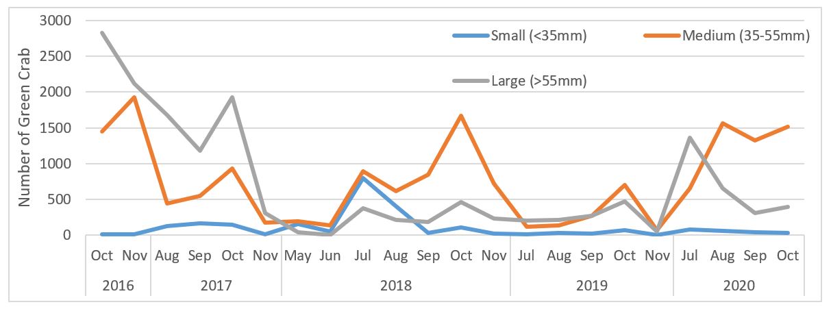
A Green crab trapping program in 2009 and 2010 was abandoned because of lack of capacity to fund the substantial effort required to successfully reduce the Green crab population. Trapping was re-initiated in 2016 after a series of harsh winters which had reduced the crab population. This new and on-going trapping program is funded by DFO and conducted by the SAB with the objective of reducing the Green crab population and minimizing its negative impacts. The direct removal of Green crab by focused trapping is an effective control technique, which has become the standard method of mitigation on the east and west coasts of Canada (DFO 2011; Duncombe and Therriault 2017). Over the past 5 years, trapping in Basin Head MPA has removed 208,128 Green crabs and reduced the average carapace size (figure 8). The eradication of an invasive species in an aquatic environment is virtually impossible once the organism has become established. Therefore, a sustained and targeted, long-term trapping effort will be needed to keep numbers of Green crab low in Basin Head.
Annual distribution per month of the carapace size classes for male green crabs
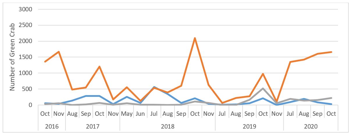
Annual distribution per month of the carapace size classes for female green crabs
Figure 8. Male (upper panel) and female (lower panel) yearly carapace width size distribution.
Long description
Color legend:
- Blue line: Small size class (less than 35 mm)
- Orange line: Medium size class (35 to 55 mm)
- Grey line: Large size class (55 mm)
| Year | Month | Small (<35 mm) | Medium (35 to 55 mm) | Large (>55 mm) |
|---|---|---|---|---|
| 2016 | October | 56 | 1,357 | 30 |
| November | 43 | 1,671 | 55 | |
| 2017 | August | 143 | 488 | 3 |
| September | 284 | 553 | 25 | |
| October | 283 | 1,201 | 63 | |
| November | 29 | 179 | 8 | |
| 2018 | May | 261 | 558 | 56 |
| June | 68 | 132 | 7 | |
| July | 564 | 541 | 13 | |
| August | 345 | 395 | 2 | |
| September | 67 | 606 | 7 | |
| October | 215 | 2,095 | 110 | |
| November | 38 | 630 | 65 | |
| 2019 | July | 11 | 65 | 1 |
| August | 25 | 217 | 1 | |
| September | 57 | 271 | 166 | |
| October | 208 | 978 | 523 | |
| November | 2 | 106 | 55 | |
| 2020 | July | 90 | 1,348 | 198 |
| August | 194 | 1,425 | 136 | |
| September | 82 | 1,608 | 153 | |
| October | 27 | 1,662 | 218 |
| Year | Month | Small (<35 mm) | Medium (35 to 55 mm) | Large (>55 mm) |
|---|---|---|---|---|
| 2016 | October | 17 | 1,452 | 2,824 |
| November | 9 | 1,931 | 2,115 | |
| 2017 | August | 125 | 445 | 1,680 |
| September | 166 | 550 | 1,178 | |
| October | 151 | 933 | 1,924 | |
| November | 13 | 178 | 307 | |
| 2018 | May | 156 | 199 | 46 |
| June | 49 | 140 | 6 | |
| July | 798 | 892 | 378 | |
| August | 408 | 613 | 214 | |
| September | 28 | 849 | 190 | |
| October | 113 | 1,670 | 460 | |
| November | 27 | 723 | 235 | |
| 2019 | July | 11 | 116 | 205 |
| August | 33 | 135 | 218 | |
| September | 23 | 275 | 271 | |
| October | 71 | 705 | 478 | |
| November | 3 | 71 | 54 | |
| 2020 | July | 80 | 653 | 1,367 |
| August | 64 | 1,560 | 658 | |
| September | 39 | 1,329 | 307 | |
| October | 29 | 1,516 | 395 |
3.2.4 Climate change
Finally, the effect of climate change in all of PEI will lead to sea level rise, and more frequent and severe storm surges, making it important to monitor the only ocean opening as well as sand dune and marsh erosion. Furthermore, climate change will likely bring ice-free winters in the Gulf of St. Lawrence and in the meantime, any increase in mobility of ice in the Northeast Arm may increase losses of Irish moss fronds due to ice scouring. Analyses of ice cover and freeze-thaw cycles over winter revealed a correlation between the increasing instability of winter temperature and the measured rate of marsh edge erosion. Sustained high water temperatures in summer will also create stress to the ecosystem. For Irish moss and Blue mussels (Mytilus edulis), temperature stress occurs above 20℃ and sustained temperatures above 28℃ can be lethal. In the summer months of 2012 to 2017, average temperatures over the Irish moss beds (as measured by the continuous temperature data loggers) exceeded the threshold for stress (20℃) on 44 to 63 days per year. Temperatures reached the lethal limit of 28℃ for 0 to 12 days per year for the same period. Over the course of the entire deployment for these loggers, the maximum duration of exposure to temperatures over 28℃ was 5 consecutive hours. If temperature continues to increase within Basin Head, it will be detrimental for both Irish moss and Blue mussels.
Climate change adaptation options that have already been implemented (e.g., small scale eelgrass restoration, Giant Irish moss restoration, Green crab removal, cultivating different clones of the Giant Irish moss to increase species resilience) and others that are being investigated (e.g. bank stabilization) will improve ecosystem resilience in the face of climate change. Coordinating management efforts across organizational and jurisdictional boundaries is also important for successful implementation of climate change adaptation strategies. The government of PEI has developed a 5 year (2018 to 2023) Climate Change Action Plan that provides a framework for adapting to a changing climate as well as reducing greenhouse gas emissions. Some actions proposed would be beneficial to Basin Head MPA. Examples of these actions include reforestation of abandoned or marginal agricultural land to increase biodiversity and enhance carbon sequestration; and increased funding support for existing programs such as the Alternative Land Use Services program and the Forest Enhancement Program which are designed to expand carbon sequestration opportunities and enhance socio-ecological resilience.
3.3 Key management priorities and actions
Key management priorities and associated actions to be undertaken during the lifetime of this management plan are presented in table 1. These are overarching priorities and actions to guide the successful management of the MPA. More specific and operational management actions are presented for each CO in (table 2 and table 3).
| Key management priorities | High level management actions |
|---|---|
| Continue to engage federal and provincial regulators to ensure they are aware of their roles and responsibilities in management of the MPA |
|
| Manage activities and pressures affecting the MPA |
|
| Monitor and report on the health and management effectiveness of the MPA |
|
| Foster public education, awareness and stewardship |
|
3.4 Specific management actions for each regulatory and non-regulatory CO
Tables 2 and 3 (below) have been modified from the last version of the management plan to describe (more specifically) the management strategies in place to achieve the desired COs. Table 2 also provides high level information on the ecological monitoring to be undertaken for each regulatory CO. More details on the monitoring protocols, indicators and strategies will be included in a monitoring plan in the next 5 years. The ecological monitoring in the tables below also reflect the results from the last Science Advisory review process that took place in June 2019 to review the monitoring activities in Basin Head MPA and their effectiveness in attaining COs (DFO 2020). A number of current monitoring activities were considered adequate but modifications to some monitoring activities and several new monitoring activities were also proposed. The recommendations from this Science Advisory process are reflected in the second column of this table. Note that proposed monitoring will be dependent on funding and capacity. Thresholds of harm, where known from literature, are included for each of the ecological indicators; current and proposed management activities are listed; and triggers for additional management action are identified. For each of the COs, related legislative acts and regulations as well as the relevant responsible authorities are listed.
| Management strategies | Ecological monitoring activities | Threshold of harm (when available), current and proposed management actions and triggers for additional actions | Related legislation / responsible authority |
|---|---|---|---|
| CO1: Maintain the quality of the marine environment supporting the Basin Head Irish moss | |||
| Ensure that water quality indicators are maintained at levels conducive to Irish moss survival. Indicators include water temperature, dissolved oxygen and nutrient and sediment loading from monitored streams. |
Short term goals (5 yrs) Nutrient loading Calculate nutrient loading entering the MPA, by taking measurements of stream flow in combination with water samples for nitrate, nitrite and phosphate concentrations from early spring to fall. In addition to monitoring nutrient loading from streams, develop a watershed nutrient model also taking into factor groundwater concentration which could provide an effective way to estimate the benefit of certain nutrient reduction strategies. |
Threshold: Threshold for eutrophication in Basin Head has not been calculated and is dependent on many factors such as flushing rate as well as internal and external nutrient loadings. Management actions:
Trigger: Trends in nutrient loading shows no decrease over time. |
Basin Head Marine Protected Area Regulations / DFO Marine Environmental Quality under the Oceans Act / DFO PEI Water ActFootnote 1 / PEI Dept. Environment, Energy and Climate Action PEI Agriculture Crop Rotation Act / PEI Dept. Environment, Energy and Climate Action PEI Environmental Protection Act and Watercourse and Wetland Protection Regulations / PEI Dept. Environment, Energy and Climate Action |
|
Water temperature Monitor continuous water temperature year-round, at three locations within the MPA (two in Northeast Arm over the Irish moss main bed and Corduroy Road bed and one in the Main Basin). |
Threshold: For Irish moss and Blue mussel, temperature stress can occur at 20℃ and mortality can occur from prolonged exposure to 28℃. Management actions:
Trigger: Maximum duration of exposure to summer temperature at Corduroy Road exceeding 28℃ was 5 consecutive hours between 2012 and 2017. Trigger for additional management action when maximum temperature duration exceeding 28℃ at Corduroy Road increases over time and acute temperatures exceeding 30℃ are observed more frequently. |
Basin Head Marine Protected Area Regulations / DFO PEI Water Act / PEI Dept. Environment, Energy and Climate Action Fisheries Act-Fish and Fish Habitat Protection Provision / DFO PEI Environmental Protection Act and Watercourse and Wetland Protection Regulations / PEI Dept. Environment, Energy and Climate Action |
|
|
Dissolved Oxygen Monitor continuous dissolved oxygen over Irish moss beds and mouth of Northeast Arm annually during ice free season. |
Threshold: Hypoxic stress occurs at or below 4 mg/L for most fish, and at or below 2 mg/L for most invertebrates, and mass mortality of animals can occur if anoxia (0 mg/L) is sustained. Management actions:
Trigger: Percentage of time in which dissolved oxygen concentrations are below 2 and 4 mg/L at Main Bed increases from year to year and anoxic event becomes more prevalent or is sustained. |
Basin Head Marine Protected Area Regulations / DFO PEI Water Act / PEI Dept. Environment, Energy and Climate Action |
|
|
Long term goals (10 yrs) Sediment loading Develop and initiate monitoring of sediment input in Basin Head. Start by determining what are the major sources of sediment (e.g., streams entering Basin Head lagoon, salt marsh erosion, bank erosion, sand coming from sand dune) and establish a baseline under various weather condition. |
|||
| CO2: Maintain the physical structure of the ecosystem supporting the Basin Head Irish moss | |||
| Monitor and where possible restore the integrity of the physical environment (i.e., dune structure, ocean opening, water depth, flushing, and adjacent salt marsh) |
Short term goals (5 yrs) Dune and Salt marsh structures Monitor changes in dune structure at the ocean opening and top of Northeast Arm (i.e., where the dune is relatively low and narrow and where a breach may most likely occur). Monitor salt marsh edge erosion every 5 years using one of the following techniques: LIDAR, satellite imagery, provincial aerial photos, drone imagery or by tracing the edge using a survey grade GPS. Ground truth salt marsh erosion yearly by measuring the change in distance between the marsh edge and rods placed at known distance from the edge. |
Threshold: A breach of the dune or major salt marsh reduction can result in significant changes to system hydrodynamics that may have positive short term and devastating long-term impacts. No known threshold at this time. Management actions:
Trigger: Dune width shrinks from year to year or suffers a sudden change and lagoon entrance is filling up due to storm activity affecting hydrodynamics Salt marsh erosion rates show persistent a increase over time compared to baseline data (i.e., 2000 provincial aerial photography). |
Basin Head Marine Protected Area Regulations / DFO PEI Natural Areas Protection Act / Dept. of Environment, Energy and Climate Action |
|
Water circulation and depth Update hydrodynamic model every 5 years or when major changes occur due to storm surges. Monitor salinity continuously to better understand tidal influences and freshwater inputs. Monitor morphology of ocean opening (cross sectional depth) and document if any dredging in the entrance has occurred. Monitor changes in water depth at low tide, sediment thickness and bottom type at 2 m intervals along 20 cross-channel transects in Northeast Arm at 5 years intervals, or more often if major storm surges occur (baseline = 2016 survey). |
Threshold: Ideal current speed for Irish moss suitable habitat is between 10 and 15 cm/s in Northeast Arm. Management actions:
Triggers: Changes in flushing rates compared to baseline (i.e., 2017 hydrodynamic model). Sediment thickness increases over time along permanent transects, leading to lagoon infilling. |
Basin Head Marine Protected Area Regulations / DFO PEI Water Act / PEI Dept. Environment, Energy and Climate Action |
|
|
Land use pattern Monitor land use pattern using provincial aerial photo (every 10 yrs). Information can also be gathered more frequently by interviews with local farmers or with ground land use surveys. Monitor municipal land use and permit approval data in the Basin Head watershed. |
Threshold: Annually, 40% of the watershed is farmed, with more than half of the land dedicated to a 3-year potato rotation. The threshold beyond which this land use threatens estuarine ecosystem viability is currently not established. Management actions:
Trigger: Major change in land use that may result in serious, long-term impacts on the Basin Head lagoon. |
Basin Head Marine Protected Area Regulations / DFO Lands Protection Act / PEI Dept. Agriculture & Land Rural Municipality of Eastern Kings Official Plan (2013)Footnote 2 Rural Municipality of Eastern Kings Subdivision and Development Control Bylaw |
|
|
Long term goals (10 yrs) Improve bathymetric profiles for Basin Head Explore options for drone-based image analysis, LIDAR or the use of depth profilers suitable for the estuarine environment to do 3D modelling of the Northeast Arm and monitor changes in bathymetric profiles. Model possible impact of dune breach and develop response scenarios. |
|||
| CO3: Maintain the health (biomass and coverage) of the Basin Head Irish moss | |||
|
Ensure a healthy and sustainable level of Basin Head Giant Irish moss in the MPA. Augment Irish moss coverage by planting Irish moss-mussel clumps on optimal bottom to reach at least 50% of original coverage as estimated when the MPA was established in 2005 (baseline = 2254 m2). Manage human activities and pressures to minimize negative impacts that can damage or kill Irish moss (e.g. anthropogenic impact which leads to eutrophication, Ulva blooms, anoxic events, sediment loading). |
Short term goals (5 yrs): Irish Moss Continue annual Irish moss subsampling by wading surveys along 2-m wide swaths on both sides of the 10 permanent transects to detect major Irish moss changes that would indicate the need for a full-bed assessment. At least, once every 5 years, conduct a slow, low-altitude drone-based photographic survey of all beds in order to locate and measure Irish moss clumps. |
Threshold: Irish moss coverage is below 25% of baseline coverage (i.e., 564 m2) and considered in poor condition. Irish moss coverage estimated in 2005 has been chosen as an arbitrary staring point for effective management. Management actions:
Trigger: Trends in Irish moss coverage (m2) and number of clumps are declining in one or more beds over time, or a significant decline is observed in the comprehensive Irish moss survey (every 5 years). |
Basin Head Marine Protected Area Regulations / DFO Maritime Provinces Fishery Regulations / DFO Oceans Act / DFO Aquatic Invasive Species Regulations / DFO |
|
Long term goals (10 yrs): Use hydrodynamic modelling to continue to refine the location of the suitable area for Irish moss production, based on water depths and current speeds. |
|||
| CO4: Maintain the overall ecological integrity of the Basin Head lagoon and inner channel | |||
|
Maintain diversity of indigenous flora and fauna. Monitor eelgrass coverage, which is considered an Ecologically Significant Species (DFO 2009b). Monitor Ulva blooms which can provide an indication of eutrophication. Control Aquatic Invasive Species entering the Basin Head MPA. |
Short term goals (5 yrs): Abundance and diversity of fish and benthic invertebrates Continue the Community Aquatic Monitoring Program to monitor trends in community abundance and diversity of fish and benthic invertebrates within the Main Basin. Initiate sampling (e.g., sediment core) within each Irish moss bed periodically to document changes in benthic diversity (epifauna and infauna), abundance of mostly sessile communities and shellfish (e.g. mussels, oysters, quahaug, clams). |
Threshold: The loss of biodiversity impairs the functioning and resilience of any ecosystem. Particular thresholds for Basin Head cannot be identified but loss of biodiversity has already been observed. Management actions:
Trigger: Declining trends in community abundance and diversity of fishes and benthic invertebrates over time. |
Basin Head Marine Protected Area Regulations / DFO |
|
Eelgrass Continue documenting eelgrass bed coverage (m2) yearly within and adjacent to Irish moss survey transects by measuring the area (m2) of each eelgrass patch. Analyze collected drone-based images, satellite imagery or acoustic survey data to estimate eelgrass coverage in Basin Head. |
Threshold: Threshold is unknown. We lack scientific knowledge of eelgrass-Irish moss dynamics under current conditions but historically, Basin Head was an eelgrass-dominated system that also supported a healthy population of Irish moss clumps. Natural re-establishment of eelgrass is currently underway and being monitored. Management actions:
Triggers: Decreasing coverage of eelgrass over time in Basin Head is detected. |
Basin Head Marine Protected Area Regulations / DFO | |
|
Green algae (Ulva spp.) Continue photo mosaic at 2 locations (i.e. Elliott Marsh, and Ching's Bridge) to document the timing and extent of seasonal growth and die-off of green algae (Ulva lactuca) coverage. Continue documenting the percent sea lettuce coverage along Irish moss survey transects and in Community Aquatic Monitoring Program, using quadrat sampling. Continue proof testing the use of time-lapse camera to document intertidal sea lettuce development at Main Bed and Elliott Marsh and develop metrics of sea lettuce dynamics (e.g. % cover, timing of onset, and collapse of blooms). |
Threshold: To see a reduction in Ulva bloom productivity, nutrient loading must be reduced such that it falls consistently below a threshold for eutrophication (to be determined). Management actions:
Triggers: Ulva coverage in Northeast Arm increases year to year. Ulva blooms start to grow earlier and last longer. |
Basin Head Marine Protected Area Regulations / DFO PEI Water Act / PEI Dept. Environment, Energy and Climate Action |
|
|
Shellfish (mussel and oyster) Perform periodic non-destructive quadrat sampling to document demographics of mussels and oysters and compare with established baseline (e.g., mussel demographic or the 2015 biodiversity survey). |
Threshold: There is no known shellfish threshold. Some historical data exist on shellfish population in Basin Head. Oyster population is currently expanding and is likely to be beneficial. Management actions:
Trigger: Declining abundance of oysters and mussels from baseline (to be established). Declining abundance and skewed size distribution (i.e. lack of small mussel size <35 mm) in Blue mussel population. |
||
|
Aquatic Invasive Species (AIS) Continue yearly deployment of biofouling collectors for early detection and monitoring of AIS. Continue Community Aquatic Monitoring Program sampling in the Main Basin to monitor temporal signal in Green crab abundance. Continue the yearly targeted Green crab trapping program. Calculate Catch per Unit Effort (CPUE) and changes in Green crab size distribution. |
Threshold targets: See Threshold targets (Crab/Trab/Day)Footnote 3 Data collected between July and August 2020 at 10 permanent monitoring locations in Basin Head were used to calculate the mean cumulative CPUE for the Main Basin (77.7) and Northeast Arm (34.1). Note that in 2020, green crab abundance was higher than in the preceding year. Carapace width of Green crab captured are below 35 mm (ie. crab size which have insignificant impacts on bivalves and eelgrass) indicating success in trapping efforts. Threshold (other invasive spp. e.g. tunicates, oyster drill, Codium): Detection of species previously not known in Basin Head lagoon is considered undesirable until proven otherwise. Management actions:
Triggers: Increasing Green crab CPUE over time. Detection of new AIS in the MPA. |
Basin Head Marine Protected Area Regulations / DFO Aquatic Invasive Species Regulations / DFO |
|
|
Long term goals (10 yrs): Conduct research to evaluate whether non-invasive technique such as environmental DNA (eDNA) with meta-barcoding could be used at various locations in the Northeast Arm to supplement the Community Aquatic Monitoring Program data and monitor AIS. |
|||
Table 3 describes non-regulatory COs which includes components such as governance, outreach and education as well as management actions and leads responsible to support these non-regulatory COs. In the next 5 years, efforts will be made to develop and track indicators over time, and evaluate whether the objectives are being achieved.
| Non-regulatory CO | Management actions | Lead responsible |
|---|---|---|
| Ensure the participation of interested and affected partners and stakeholders in the management of the MPA. |
Short term goals: Continue the annual advisory committee meeting to report on management progress and challenges. Encourage partner and stakeholder involvement in the management of the MPA by implementing their advice when possible and providing them with funding to advance the monitoring and management of the MPA and contribute to positive ecological, social, economic and cultural outcomes. Review advisory committee terms of reference and membership every 5 yrs. |
BHAC |
|
Long term goals: Increase provincial, Indigenous and Environmental Non-Government Organization (ENGOs) involvement in MPA monitoring and management, related public education and outreach. |
BHAC | |
| Foster public stewardship of the Basin Head MPA through education and awareness of the ecosystem and the existing conservation measures. |
Short term goals: Update the DFO Basin Head MPA website by adding newly published reports and articles, videos and pictures. Continue collaborating with SAB to increase public awareness through community events at the Basin Head interpretative day park (e.g. Eco-tours, Oceans Day activities). Increase involvement of Indigenous groups to raise public awareness of the cultural significance and Traditional Indigenous Knowledge connected to the MPA through community events at the Basin Head interpretative day park (e.g. Indigenous archaeological sites in the watershed). Conduct information session for residents, farmers, recreational fishers and waterfowl hunters on the monitoring and restoration work undertaken in Basin Head. |
DFO (with support from Mi'kmaq Confederacy of PEI and Conservation Groups on the advisory committee) |
|
Long term goals: Develop educational materials to raise awareness of the MPA in local schools and youth. Develop and install signage that clearly show the legal boundary between Zones 1 and 2. |
DFO | |
| To promote scientific research and monitoring to increase the level of understanding of the Basin Head MPA. |
Short term goals: Continue to collaborate with University of PEI and other universities, to promote research. Continue to support SAB for their monitoring and restoration efforts. Continue to identify potential partners for collaborative research, monitoring or restoration projects in the Basin Head watershed. |
DFO (with support of the BHAC) |
|
Long term goals: Share strategies and plans with, and learn from, other coastal MPAs in cold temperate waters of Canada and the USA. |
DFO | |
| To promote and if possible, enhance social and environmental conditions in the surrounding watershed as required to avoid adverse impacts on the Basin Head ecosystem. |
Short term goals: Promote and implement relevant BMPs to reduce the impacts of nutrient enrichment and sediment loading on marine environmental quality within the Basin Head ecosystem. Reduce the spread of aquatic invasive species in the Basin Head ecosystem by promoting public awareness and stewardship initiatives. Continue supporting habitat restoration activities to maintain and enhance the quality of the Basin Head ecosystem. Continue supporting educational and stewardship activities which may promote tourism (e.g., ecotours). |
DFO (with support from PEI Dept. of Agriculture and Land and Dept. of Environment, Energy and Climate Action) DFO (with the support of DFO Science and the PEI Invasive Species Council) BHAC |
|
Long term goals: Continue integrating climate adaptation actions in the future iteration of the Basin Head Management Plan. |
DFO (with support from the advisory committee) |
3.5 Research, monitoring and restoration
Research and monitoring are essential activities that support MPA management. A wide variety of monitoring and research are expected as described in table 2 and will be conducted by DFO as capacity and resources allow. Nevertheless, DFO will promote, and in many cases, fund and support scientific research and monitoring by other partners from environmental/community groups, academia and government.
Since 2014, research activities have included an assessment of the Green crab population and an assessment of Irish moss and Green crab interactions (both direct and indirect) under laboratory and field conditions conducted by the University of PEI (Tummon Flynn et al. 2019). More recently, research has been undertaken by Dalhousie University to characterize the Basin Head thermal and nutrient regimes including the influence of diffuse and discrete (springs and seeps) groundwater discharge. The MPC program will encourage ecological research as well as research that contributes to knowledge of human history and socio-economic importance in the MPA. Key ecological research needs in the next 5 years include:
- continue research to characterize the spatial and temporal patterns of the thermal regime in Basin Head to understand possible future impacts of climate change (temperature rise), especially on Irish moss and Blue mussels
- continue research to model nutrient loading from multiple sources (streams, groundwater, sediment) to develop BMPs for agricultural activities
- understand dynamic interactions between Irish moss and eelgrass, and evaluate if eelgrass beds likely facilitate conditions that support the Giant Irish moss and contribute to stabilizing benthic habitat (i.e., facilitation cascade effect)
- further understand trophic interactions provided by the Irish moss-blue mussel clumps (i.e., coexisting ecosystem engineers) such as refugia function which has already been documented for mud crab (Tummon Flynn et al., 2020) and facilitation role of these foundation species on other native organisms
Monitoring activities in the Basin Head MPA have focused to date on water quality indicators (i.e., nutrient concentration, temperature, dissolved oxygen), assessment of the abundance and distribution of Irish moss, assessment of blooms of sea lettuce (Ulva spp.), fish community assemblages in the lagoon, bird population surveys, aquatic invasive species, hydrological modelling and studies to better understand and document threats (e.g., land use, soil erosion, salt marsh erosion, winter ice) to Irish moss (Joseph et al., 2021).
The first ecological monitoring plan for Basin Head MPA will be developed by DFO science and will mainly be based on the recent Science Advice (DFO 2020). This plan will describe Basin Head monitoring indicators that are good integrators of ecosystem conditions and that have direct links to Irish moss itself, and the ecosystem components associated with Irish moss persistence and recovery. Outcomes of the monitoring plan are central to informing management actions that are designed to minimize the effects of human activities on the ecosystem. The monitoring plan will be reviewed every 5 years to ensure monitoring activities are addressing management priorities.
Because of the near extirpation of the Basin Head Irish moss, research into restoration strategies was initiated in 2015. Concerted efforts were put towards restoring Irish moss in Basin Head's Northeast Arm by planting artificially created moss-mussel clumps using giant Irish moss grown in tanks at the National Research Council research station and commercially grown Blue mussels from PEI (Joseph et al., 2021). Over the years, experimental planting took place on different substrate types, using different mussel sizes and various shapes and sizes of clumps. Based on those trials, the most successful clumps include a handful of Giant Irish moss with minimum of 20 adult mussels (> 5 cm shell length) and large oyster shells used as a base to prevent clumps from sinking into soft sediment. All clumps should be planted on firm bottom, in moderately shallow water (greater than 10 cm during extreme low tides) and in current swept areas (average current speed ranging from 10 to 15 cm/s). The addition of these moss-mussel clumps adds 3-dimentional structure to the bottom that favors an increase in biodiversity.
3.6 Surveillance, enforcement and compliance
An enforcement and compliance plan for the Basin Head MPA is reviewed and approved yearly by the director of the Conservation and Protection Program at DFO and describes the enforcement requirements as identified in the Basin Head Marine Protected Area Regulations as well as enforcement measures that will be used to achieve the COs. As the lead federal authority for the MPA, DFO has the overall responsibility for ensuring compliance with, and enforcement of, the regulations. This is undertaken through the department's enforcement responsibilities under the Oceans Act and the Fisheries Act, as well as other legislation regarding fisheries conservation, environmental protection, habitat protection and marine safety. Enforcement officers designated by the Minister under section 39 of the Oceans Act would enforce the proposed regulations for the MPA. Offences would be dealt with under subsection 39.6 of the Oceans Act, as would any offences under Section 78 of the Fisheries Act. Contravention of the proposed regulations would carry fines of up to $8,000,000 for an offence punishable on summary conviction and up to $12,000,000 for an indictable offence, in accordance with subsection 39.6 of the Oceans Act. Contraventions of activity plan approvals and conditions could also result in charges under other applicable Canadian legislation such as the Fisheries Act or the Species at Risk Act. Other federal and provincial regulators can also play a role in managing activities around the MPA and supporting the enforcement of the regulations.
Following the MPA designation, the BHAC identified a need for enforcement with respect to illegal fishing and the use of motorized vessels in areas of the MPA where these activities are not permitted. More recently the advisory committee has also identified concerns on the introduction of AIS from recreational activities (paddle board, kayak, canoes) and other non-motorized vessel coming from other bays and possibly introducing AIS (e.g., tunicates) into the MPA. The permitted oyster relay fishery in zone 2 and especially in the Northeast Arm has also been flagged as a concern since oyster tongs used for this fishery can potentially disturb or damage eelgrass and restored giant Irish moss which would have drifted from zone 1 into zone 2 (spillover effect from restoration work). A recent increase in the oyster population in the MPA could also lead to an intensified oyster relay fishery and more disturbance and/or damage to recently grown eelgrass beds and giant Irish moss located near the boundary of zone 1 and 2.
DFO fishery officers in Souris will serve as the primary deliverers of the compliance program and may be complemented by other law enforcement personnel (or enforcement officers so designated by the minister according to Section 39 of the Oceans Act). Currently, the primary means of surveillance and enforcement in the Basin Head MPA is through land-based patrols conducted throughout the year but more frequently during seasons when commercial and recreational fisheries are more prevalent. A high level of local support for the MPA suggests that a community watch initiative could complement DFO surveillance activities.
3.6.1 Reporting accidents and violations
Every person involved in, or aware of, accidents, violations or environmental emergencies in the MPA must report them to the appropriate authorities. Under the Fisheries Act, users are also legally obligated to take reasonable measures to prevent or mitigate an accident, spill or environmental emergency. A Regional Environmental Incident Response Protocol (for Non-Coast Guard Personnel) has been approved in 2020 for the Gulf Region. This protocol has been developed to define DFO's role and responsibilities for the management of environmental incidents related to marine and freshwater environments by non-Coast Guard personnel and describes internal notification process to alert various sectors of an incident as well as their roles in preparedness, response and restoration/recovery.
3.7 Education and outreach
Public awareness and education are critical factors in ensuring the long-term success of MPAs, especially those like the Basin Head MPA that have coastal access. Compliance with MPA regulations is expected to be higher when stakeholders in the local community, MPA users, and the general public are aware of the ecological importance of Basin Head, the COs and management strategies of the MPA. Since designation of the MPA, several partners have been involved in education and outreach activities. Education, awareness and stewardship initiatives will be encouraged and coordinated where possible with outreach program that already exist in Basin Head, such as those undertaken by SAB and the Basin Head Fisheries Museum. Future outreach initiatives will also be sought with other partners such as the Mi'kmaq Confederacy of PEI and Island Nature Trust.
Over the years, many educational and outreach products were developed including display panels and pamphlets providing information on the historical, cultural and ecological values of Basin Head, the Oceans Act and MPAs. An interactive educational touch screen display has been installed at the fisheries museum which communicates information on the MPA program and highlights MPAs across Canada. The kiosk also provides an overview of Basin Head MPA which allow visitors to understand the ecological importance, its threats and the types of research and monitoring that are taking place.
The SAB has led since 2014 a “beyond the beach” tour to discover Basin Head and its surroundings. This educational activity explores the history of the community starting with the first settlers, local fishing industry and the importance of the Basin Head Harbor, followed with a guided walk along the beach explaining the importance of the barrier sand dunes and a beach seine sweep with ‘'hands-on'' experience to explore the rich coastal environment and diversity within the marine ecosystem of the Basin Head MPA.
A new Basin Head Interpretive Park was completed in 2019. This new park located next to the Basin Head Provincial Park, Basin Head Beach and the Basin Head Fisheries Museum has improved visitors' experience, while promoting education and protection of the Basin Head Lagoon. This project was completed with the financial help of Atlantic Canada Opportunities Agency, the Government of PEI and DFO and was led SAB. The interpretive park includes new interpretive panels, boardwalk, upgrades to the boat launch, new picnic shelter, research building and improved parking area. This new park will be ideal for interpretative and outreach activities related to Basin Head MPA and awareness of the cultural significance and Traditional Indigenous Knowledge connected to the MPA.
Specific projects to be addressed in the lifetime of this management plan, contingent on the availability of funds and resources, are identified below.
Basin Head MPA signage, panels and kiosk
- develop a plan to add MPA boundaries signage which would legally delineate between the core conservation zone 1 and zone 2
- evaluate different options such as signage on land and/or informational buoy placed in the middle of the channel and involve the Conservation and Protection officers
- multiple panels have been produced over the years, some of which were developed in the early years of MPA establishment and now need to be updated or repaired
- interactive kiosk also needs to be updated to reflect new MPAs established across Canada, new MPA minimum protection standards, and the recent restoration efforts
- maintain existing interpretative panels and update information as needed
Indigenous involvement
Eastern PEI is rich in early Indigenous culture. Paleo-Indian artifacts dating as far back as 9,000 years have been found at Basin Head and more recently Mi'kmaq people used the area seasonally for hunting and fishing. Efforts have been made to highlight significant examples of Indigenous cultural heritage within the Basin Head MPA recently through the panels at the Basin Head Interpretative Park.
We will work to increase involvement of Indigenous Groups in the management of the MPA and to raise awareness of the cultural importance and traditional knowledge connected to the MPA. It may be possible to have community events at the Basin Head interpretative day park to showcase Indigenous archaeological artifacts, share stories about fishing traditions of the past and present, and demonstrate traditional arts such as basket weaving, beading and drumming.
Public outreach and educational material
The MPC program at DFO will seek opportunities to develop and distribute educational materials about the MPA to highlight the importance of conservation areas to protect nature and biodiversity. This could include the creation of an educational video to highlight the ecological importance of the MPA. The video could be placed online and potentially used in other public venues. Other initiatives could include seeking out new education and stewardship initiatives with local schools and college and university classes, such as on site or in class learning opportunities, field trips and guided tours. Public meetings could also be organized annually to provide regular updates and information about the work undertaken in Basin Head to community and Indigenous organizations. The "Souris and Area Watershed News" is another way to communicate activities undertaken in Basin Head.
Website
DFO will be responsible to regularly update the Basin Head MPA information on the DFO website such as adding on-line resources (e.g., yearly progress reports, updated management plans and links to primary literature); and explore the possibility of adding a storyboard to the DFO website showcasing the successful restoration efforts undertaken at Basin Head that have led to the continued survival of the distinct strain of Irish moss.
4.0 Governance
The Oceans Act allows DFO to collaborate with a variety of stakeholders to achieve the goals of the Oceans Act including the management of the projects under the MPA program.
The Basin Head MPA is managed by the MPC program within DFO, on behalf of the Government of Canada. Guidance for the management of the MPA is provided by the BHAC, established in 2005 under the authority of the Section 32(c) of the Oceans Act. Furthermore, several other federal and provincial government departments have regulatory roles and responsibilities in the Basin Head lagoon.
4.1 Roles and responsibilities
4.1.1 DFO
As the lead authority for the MPA, DFO has the primary responsibility for its protection and management. The department has invested significant program resources into managing, monitoring and enforcing regulations in the MPA. DFO core responsibilities include:
- Implement and coordinate, with other provincial government, municipality and non-government organizations that have jurisdiction in and around the MPA, the management actions set out in this plan to ensure long-term conservation, protection, and sustainable use of the MPA.
- Promote compliance with the regulations among all user groups and other government regulators.
- Coordinate and carry-out surveillance of the MPA and enforcement of the regulations.
- Provides advice to those considering activities in the MPA, and coordinates the review of activity plans received through the plan submission process.
- Support and undertake monitoring and scientific research in the MPA, contingent on the availability of funds and resources.
- Facilitate public awareness and distribute educational materials to stakeholders and users of the MPAs, contingent on the availability of funds and resources.
- Build capacity in support of stewardship initiatives.
- Review management and monitoring plans as well as priorities in the MPA to ensure objectives are met and report yearly progress through the Basin Head Management Plan implementation progress report
The MPC provides an overall facilitation and coordination function for the MPA. This role requires ongoing dialogue with partners, regulators and various stakeholders.
4.1.2 Government of PEI
Several provincial departments play a significant role in managing activities in and around the MPA, and many provincial members are part of the advisory committee (appendix 2). Although each regulatory body has different responsibilities and interacts with different sectors, they have a common goal of promoting the Basin Head MPA COs (regulatory and non-regulatory) as well as compliance with the Basin Head Marine Protected Area Regulations. Core responsibilities for these departments as they relate to the Basin Head MPA include:
- Ensuring awareness of the MPA within their department and minimizing impacts from human activities by ensuring compliance with their regulations that govern authorized activities.
- Ensuring surveillance and enforcement of land-based activities.
- Assisting DFO, when applicable, in monitoring and research activities.
- Coordinating with the MPA manager to ensure that applications for works and undertakings in and around the MPA are submitted and referred to DFO's Fish and Fish Habitat Protection Program, when applicable.
In addition to their regulatory responsibilities, several provincial departments have representatives on the BHAC (appendix 2). Furthermore, the bi-lateral arrangement with the PEI Department of Fisheries and Communities provides a regular and ongoing forum for DFO and PEI provincial agencies involved in oceans management. This forum provides a venue to address the ongoing requirements for the Basin Head MPA and to provide updates on management issues or concerns.
4.1.3 BHAC
The BHAC facilitates dialogue among DFO, other regulators and stakeholders, regarding implementation of the MPA management plan. Advisory committee members are representative of the local community and industries, Indigenous community, academia, conservation/non-governmental organizations, Rural Municipality of Eastern Kings, and various provincial departments that have an interest in the MPA (appendix 2). Members provide skills, local knowledge, and experience related to conservation, management, and use of the area.
The BHAC provides advice to DFO and other regulators who make decisions related to the Basin Head lagoon and its management. While the committee is recognized as a key mechanism for collaboration, it does not have decision making authority related to the MPA regulations or regulations of any other government department that has legal jurisdiction in Basin Head. DFO is committed to integrating advice from the BHAC when making decisions regarding the MPA, provided that the advice is consistent with legislation, regulations, and policies that guide management of the area. The committee will play a major role in the implementation of the management plan. The following are the primary activities of the BHAC:
- Provides a regular forum to exchange information and views among a core group of government and non-governmental organizations with interests in Basin Head.
- Reviews the development of management plan components, regulatory proposals, and associated materials such as yearly progress reports.
- Provides advice to DFO on proposals for activities within the MPA boundary.
- Provides input on activities of other departments or organizations mandated or involved in the protection of the Basin Head lagoon and adjoining sand dunes and salt marshes.
- Discusses and recommends monitoring and research activities that address the needs of the MPA.
- Identifies outreach opportunities and assists with the development and delivery of educational materials for the general public.
- Participates in the review and evaluation of COs, management effectiveness and the contributions of committee members.
The respective government agencies are expected to appoint their representatives through an internal decision making process to be part of the advisory committee. Non-government agencies will be invited by DFO to participate. If needed, guests could also be appointed by the advisory committee and could include but are not limited to:
- a resource person involved in the MPA monitoring
- a marine plant specialist
- an aquatic invasive species specialist
- a nutrient modelling specialist
The committee is co-chaired by DFO and SAB. The MPC staff members perform all administrative functions related to the committee and meetings are organized collaboratively by the co-chairs. To keep all stakeholders updated, BHAC meets annually to discuss research, monitoring and restoration activities, enforcement, and emerging issues. The terms of reference for the BHAC are available upon request from MPC.
5.0 References
- Coffin, M.R.S, Courtenay, S.C., Knysh, K.M., Pater, C.C., and van den Heuvel, M.R. 2018a. Impacts of hypoxia on estuarine macroinvertebrate assemblages across a regional nutrient gradient. FACETS 3: 23–44.
- DFO. 2008. Ecological Assessment of Irish moss (Chondrus crispus) in Basin Head Marine Protected Area. DFO Can. Sci. Advis. Sec. Sci. Advis. Rep. 2008/059.
- DFO 2009a. Operational Management Plan Basin Head Marine Protected Area. Oceans and Habitat Branch, Gulf Region. Cat. No. Fs 119/2009E. 34p
- DFO. 2009b. Does eelgrass (Zostera marina) meet the criteria as an ecological significant species? DFO Can. Sci. Advis. Sec. Sci. Advis. Rep. 2009/018.
- DFO. 2010. Ecological assessment of the invasive European green crab (Carcinus maenas) in Newfoundland 2007-2009. DFO Can. Sci. Advis. Sec. Sci. Advis. Rep. 2010/033.
- DFO 2015. Basin Head Marine Protected Area: 2014-2015 Management Plan Implementation Progress Report. Gulf Region Basin Head Management Series. 2015/03: vii + 12p.
- DFO. 2016. Basin Head Marine Protected Area: 2014 Operational Management Plan. Basin Head Management Series. 2016/01: viii + 40p.
- DFO. 2020. Review of monitoring activities in the Basin Head Marine Protected Area in the context of their effectiveness in evaluating attainment of conservation objectives. DFO Can. Sci. Advis. Sec. Sci. Advis. Rep. 2020/003.
- Duncombe, L.G., and Therriault, T.W. 2017. Evaluating trapping as a method to control the European green crab, Carcinus maenas, population at Pipestem Inlet, British Columbia. Management of Biological Invasions 8: 235-246.
- Joseph, V., Thériault, M.-H., Novaczek, I., Coffin, M., Cairns, D., Nadeau, A., Boudreau, M., Plourde, M.-A., Quijon, P.A. and Tummon Flynn, P. 2021. Review of monitoring activities in Basin Head Marine Protected Area in the context of their effectiveness in evaluating attainment of conservation objectives. DFO Can. Sci. Advis. Sec. Res. Doc. 2021/044. xi + 89 p.
- Judson, D., Gallant, R., and Howlett, P. 1987. Basin Head ‘Giant' Irish moss biomass survey July-August 1987 and controlled harvest project. Report of the Prince Edward Island Department of Fisheries. 16 p.
- Island Nature Trust. 2001. Community use of the Basin Head Lagoon, Prince Edward Island. Report prepared by the Island Nature Trust for the Basin Head Lagoon Ecosystem Conservation Committee. 26 pp. (availability through DFO)
- McCurdy, P. 1979. A preliminary study of the ecology of Basin Head harbour and South Lake P.E.I. Final report, Canada Summer Job. Corps Project 16-01-009S. 57 p.
- McCurdy, P. 1980. Investigation of a unique population of Chondrus crispus in Basin Head Harbour, Prince Edward Island. Internal report to National Research Council of Canada under Contract CS155-0-6302, 080-005, 34 pp.
- Rural Municipality of Eastern Kings. 2013. Official Plan.
- Sharp, G., Semple, R., Connolly, K., Blok, R., Audet, D., Cairns, D., and Courtenay, S. 2003. Ecological assessment of the Basin Head lagoon: A proposed Marine Protected Area. Can. Manuscr. Rep. Fish. Aquat. Sci. 2641, 69 pp.
- Tummon Flynn, P., Garbary, D., Novaczek, I., Miller, A., and Quijon, P.A. 2018. The unique giant Irish moss (Chondrus crispus) from Basin Head: health assessment in relation to reference sites on Prince Edward Island. Botany 96: 805–811. https://cdnsciencepub.com/doi/10.1139/cjb-2018-0081
- Tummon Flynn, P., Lynn, K.D., Cairns, D.K., and Quijon, P.A. 2019. The role of the non-indigenous green crab (Carcinus maenas) in the decline of a unique strain of Irish moss (Chondrus crispus): direct and indirect effects. ICES Journal of Marine Science, https://doi.org/10.1093/icesjms/fsz130
- Tummon Flynn, P., McCarvill,K., Lynn, K.D., and Quijon, P.A. 2020. The positive effect of coexisting ecosystem engineers: a unique seaweed-mussel association provides refuge for native mud crab against a non-indigenous predator. PeerJ, 8:e10540 https://doi.org/10.7717/peerj.10540
Appendix 1: Basin Head Marine Protected Area Regulations
Interpretation
1 (1) The following definitions apply in these regulations.
- Area means the Basin Head Marine Protected Area designated under section 2. (zone)
- Vessel has the same meaning as in section 2 of the Canada Shipping Act. (bâtiment)
- Waters means, in addition to the waters, the seabed and subsoil below the waters to a depth of two metres. (eaux)
(2) In these regulations, all geographical coordinates (latitude and longitude) are expressed in the North America Datum 1983 (NAD 83) geodetic reference system.
(3) In the schedule, the lines connecting the points are rhumb lines.
Designation
2 The areas of the sea at Basin Head comprised of the management zones described below — and depicted in the schedule — are together designated as the Basin Head Marine Protected Area:
- (a) Zone 1, consisting of waters lying generally northeast of a rhumb line connecting points at 46°23′20″ N, 62°06′10″ W and 46°23′18″ N, 62°06′08″ W, that are within an area of the sea bounded by the low-water line of the harbour and by the rhumb line to its points of intersection with the low-water line;
- (b) Zone 2, consisting of waters that are within an area of the sea bounded by the low-water line of the harbour and by the following rhumb lines to their respective points of intersection with the low-water line, namely,
- (i) a line connecting points at 46°23′20″ N, 62°06′10″ W and 46°23′18″ N, 62°06′08″ W, and
- (ii) a line connecting points at 46°22′39″ N, 62°06′29″ W and 46°22′40″ N, 62°06′29″ W; and
- (c) Zone 3, consisting of waters that are within an area of the sea bounded by the low-water line of the Northumberland Straight and by the following rhumb lines, namely,
- (i) to its points of intersection with the low-water line, a line connecting points at 46°22′39″ N, 62°06′29″ W and 46°22′40″ N, 62°06′29″ W,
- (ii) to its point of intersection with the low-water line, a line connecting points at 46°23′51″ N, 62°04′30″ W and 46°22′55″ N, 62°04′02″ W,
- (ii) a line connecting points at 46°22′55″ N, 62°04′02″ W and 46°21′07″ N, 62°07′36″ W, and
- (iv) to its point of intersection with the low-water line, a line connecting points at 46°21′07″ N, 62°07′36″ W and 46°22′04″ N, 62°08′04″ W.
Prohibited activities
3 (1) In the area, no person shall
- (a) disturb, damage or destroy, or remove from the area, any living marine organism or any part of its habitat; or
- (b) carry out any activity — including depositing, discharging or dumping any substance, or causing any substance to be deposited, discharged or dumped — that is likely to result in the disturbance, damage, destruction or removal of a living marine organism or any part of its habitat.
(2) despite subsection (1), a person may carry out any activity excepted under section 4 or any scientific or educational activity for which a plan is approved under section 6.
Exceptions
4 The following activities may be carried out in the area:
- (a) the following fishing activities, namely,
- (i) fishing that is carried out in accordance with the Aboriginal Communal Fishing Licences Regulations,
- (ii) in zone 2 or 3, any recreational fishing activity that is carried out in accordance with the Maritime Provinces Fishery Regulations or the Wildlife Conservation Act of PEI, R.S.P.E.I. 1988, c. W-4.1, and
- (iii) in zone 2 or 3, any commercial fishing activity that is carried out in accordance with the Atlantic Fishery Regulations 1985, or the Maritime Provinces Fishery Regulations;
- (b) in zone 2, the operation of a motorized vessel south of a rhumb line connecting points at 46°22′56″ N, 62°06′39″ W and 46°22′56″ N and 62°06′34″ W solely for the purpose of transiting that area in order to launch the vessel from, or land it at, a boat launch;
- (c) any of the following activities — for which approval or authorization is not required under the Canadian Navigable Waters Act or the Fisheries Act, as the case may be, or that is carried out in accordance with an approval or authorization required under either of those acts — namely,
- (i) in zone 2, the maintenance, repair or removal of a bridge, wharf or boat launch, and
- (ii) in zone 3, the maintenance, repair or removal of a bridge or wharf; and
- (d) any activity that is carried out for the purpose of public safety, national defence, national security or law enforcement or in response to an emergency.
Activity plan
5 Every person who proposes to carry out a scientific or an educational activity in the area shall submit to the minister for approval, not less than 60 days before the day on which the activity is proposed to begin, a plan that contains the following information and documents:
- (a) the name, address and telephone number and, if applicable, the facsimile number and electronic mail address of a person who can be contacted in respect of the plan;
- (b) a detailed description of the proposed activity that sets out:
- (i) its purpose,
- (ii) the period or periods during which it is to be carried out,
- (iii) a map on which its location is identified,
- (iv) the types of data that are to be collected, if any, and the sampling protocols or other techniques to be used to collect the data,
- (v) the types of equipment, if any, that are to be used during the proposed activity, including those for gathering data and, if any of the equipment is to be anchored or moored in the area, the methods by which the anchoring or mooring is to be conducted,
- (vi) the type and identity of every vessel that is to be used to carry out the proposed activity, and
- (vii) every substance, if any, that is to be deposited, discharged or dumped within the area during the proposed activity;
- (c) an assessment of the environmental effects that are likely to occur within the area as a result of the proposed activity; and
- (d) a list of every license, permit, authorization or consent obtained or applied for in respect of the proposed activity.
6 (1) The minister shall, within 30 days after the day on which a plan that is submitted in accordance with section 5 is received, approve the plan if the proposed activity is not likely to damage or destroy the habitat of a living marine organism in the area and
- (a) in the case of a scientific activity that is proposed to be carried out in zone 1, the activity is for the purpose of managing the area or monitoring the effectiveness of conservation measures implemented in the area; and
- (b) in the case of an educational activity that is proposed to be carried out in zone 1, the activity is for the purpose of increasing public awareness of the area or providing information in respect of the conservation measures implemented in the area.
(2) Despite subsection (1), the minister shall not approve a plan if the cumulative environmental effects of the proposed activity, in combination with any other past and current activities carried out within the area, are likely to damage or destroy the habitat of living marine organisms in the area.
Reporting of accidents
7 Every person involved in an accident that is likely to result in any disturbance, damage, destruction or removal prohibited under subsection 3(1) shall, within 2 hours after its occurrence, report the accident to the Canadian Coast Guard.
Coming into force
8 These regulations come into force on the day on which they are registered.
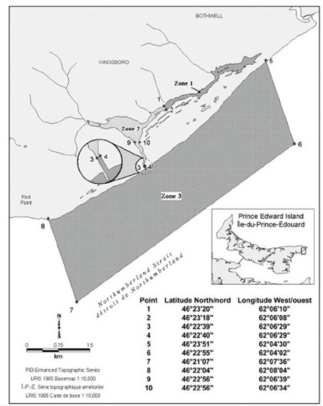
Figure 9. Delineation of the Basin Head MPA boundaries.
Long description
| Point | Latitude North | Longitude West | Description |
|---|---|---|---|
| 1 | 46°23'20” | 62°06'10” | Western boundary of zone 1 (northern point) |
| 2 | 46°23'18” | 62°06'08” | Western boundary of zone 1 (southern point) |
| 3 | 46°22'39” | 62°06'29” | Southern boundary of zone 2 (western point) |
| 4 | 46°22'40” | 62°06'29” | Southern boundary of zone 2 (eastern point) |
| 5 | 46°23'51” | 62°04'30” | Coastal eastern point of zone 3 |
| 6 | 46°22'55” | 62°04'02” | Seaward eastern point of zone 3 |
| 7 | 46°21'07” | 62°07'36” | Seaward western point of zone 3 |
| 8 | 46°22'04” | 62°08'04” | Coastal western point of zone 3 |
| 9 | 46°22'56” | 62°06'39” | Marks the narrowing of the channel in zone 2 |
| 10 | 46°22'56” | 62°06'34” | Marks the narrowing of the channel in zone 2 |
Appendix 2: BHAC members
Co-chairs and secretariat
- MPC Program, DFO
- SAB
Active members
- Science Branch, DFO
- Conservation and Protection Branch, DFO
- PEI Department Environment, Energy and Climate Action
- PEI Department of Fisheries and Communities
- PEI Department Economic Growth, Tourism and Culture
- Rural Municipality of Eastern Kings
- Island Nature Trust
- University of PEI
- Mi'kmaq Confederacy of PEI
- Fishing Industry Representative
- Agriculture Industry Representative
Proposed new members
- PEI Department Agriculture and Land
- University of PEI, Climate Change Laboratory
- Local Community Representative
- Date modified: