
Integrated Management Planning
Placentia Bay, Newfoundland and Labrador
Table of Contents
- Integrated Management (IM)
- Why Placentia Bay?
- Introduction
- Coastal Landforms (Geomorphology)
- Community Based Coastal Resource Inventories
- Shipping Lanes and Water Depth (Bathymetry)
- Plants and Animals
- Fisheries and Aquaculture
- Ecological Reserves and Special Places
- Industry
- Current Status
- References
Integrated Management (IM)


The Placentia Bay / Grand Banks Large Ocean Management Area (LOMA) is one of five priority areas in Canada identified for Integrated Management (IM). Placentia Bay is an area within the LOMA that has been identified as a Coastal Management Area due to the increasing level of human activities. The Placentia Bay IM initiative is focused on integrated planning and management of human activities so that they do not conflict with one another. The Placentia Bay Integrated Management Plan will consider all factors necessary for the conservation and sustainable use of marine resources, shared use of ocean spaces, as well as social, cultural, economic and environmental aspects of the area.
Why Placentia Bay?
Emerging community-based approaches to marine resource management reflect the changing role of government. Under the Oceans Act, it is clearly stated that the Minister of Fisheries and Oceans
'...shall lead and facilitate the development and implementation of plans for the integrated management of all activities or measures in or affecting estuaries, coastal waters and marine waters...of Canada...'
In the early 1990's, the Public Review Panel on Tanker Safety and Marine Spills Response Capability identified Placentia Bay as the marine area with the highest potential for an oil-related environmental accident in Canada. More than 365 islands and reefs are found in the bay where visibility can be reduced to less than one kilometre on an average of 187 days per year. Footnote 2 The reopening of the oil refinery at Come By Chance in 1987, along with the Newfoundland Transhipment Terminal becoming operational in 1998, has increased tanker traffic and the risk of accidents.
In 1997, the Terra Nova Project Environmental Assessment Panel recommended that
'…the Government of Newfoundland and Labrador establish a coastal zone management plan for the Avalon Peninsula and west side of Placentia Bay'.
The provincial government has accepted this recommendation and Fisheries and Oceans Canada has stated that it recognizes the sensitivity of Placentia Bay and will work on initiatives towards integrated management of the area.
Introduction
Placentia Bay lies on a north-northeast axis, opening to the Atlantic Ocean at the southwest. It separates the Avalon Peninsula on the east from the Burin Peninsula on the west and is large, deep and ice-free, which allows year-round shipping in and out of the bay.
Placentia Bay provides habitat for many species of marine plants, fish, mammals and birds. Historically, valuable fisheries in the area supported communities on the coastline and islands of the bay. Today, Placentia Bay has 26 incorporated and 30 unincorporated communities, and another 10 smaller settlements that have an average population of approximately 40 people. Census totals for 1991 and 1996 were 30,562 and 28,817 people respectively.Footnote 11 By 2001, population had decreased to approximately 25,000 people.
Placentia Bay is an area of expanding marine transportation and coastal development. With the growth of the oil and gas industry in Newfoundland and Labrador, Placentia Bay is the largest oil handling port in Canada.Footnote 2


Coastal Landforms (Geomorphology)
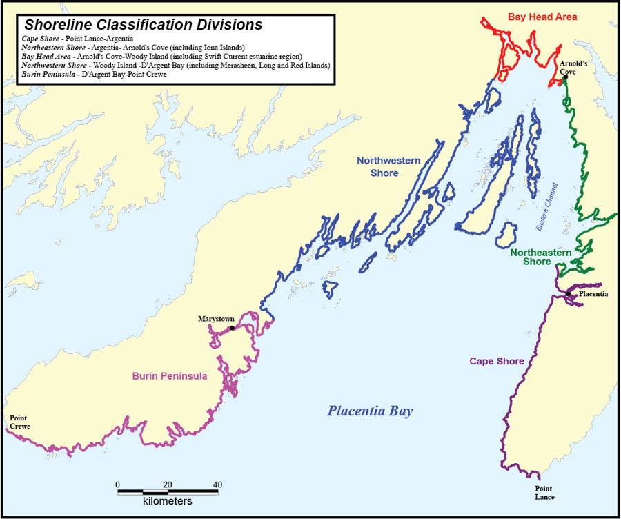
Placentia Bay is a large bay on the south coast of Newfoundland. The opening, or mouth, of the bay is approximately 145 km wide, and the bay is approximately 125 km long. At its midpoint, the bay is approximately 240 m deep.Footnote 7 Placentia Bay has many islands, shoals, reefs and banks as well as three well-defined channels. The Western Channel lies between the Burin Peninsula and Merasheen Island, the Central Channel lies between Merasheen Island and Long Island and the Eastern Channel lies between Long Island and the Avalon Peninsula. The Eastern Channel is the largest of the three in both width and depth and is the principal channel in the bay used for shipping and transportation.Footnote 17
Placentia Bay is characterized by deep water and exposure to southwesterly winds and currents. The bay entrance is unobstructed, allowing waves unrestricted access to the region. Shorelines are dominated by coarse-grained gravel deposits and cliffs; mixed sand and gravel beaches are uncommon and sand dominated systems are rare. Estuaries develop at the heads of most deep embayments along the northeastern and northwestern areas of the shore and the development of tidal flats is rare.Footnote 4 Shorelines are dominated by onshore-offshore movement of sediment, with little shore-parallel movement. This pattern implies that sediments and contaminants, once introduced into the system, will remain for a considerable amount of time within individual coves and smaller embayments.
Beaches throughout the region are marked by seasonal and yearly changes in form and texture. The amount that these beaches change over time is exceptional; stability is not a characteristic of most of these shores.
The divisions for shoreline classification have been adopted from Catto et al. (1997) and are listed in the map shown above.
Community-Based Coastal Resource Inventories

Fisheries and Oceans Canada (DFO) has been working with community groups since 1996 to document coastal fisheries resources as well as other information and data. This information has been collected through direct contact with individuals and stakeholders in coastal communities around the province. Knowledgeable people in the community were interviewed to identify areas where specific resources were known to occur. These areas were mapped on nautical charts and topographical maps. Additional information was collected related to the resources (e.g. season fished, gear used). This information was used to produce Community-Based Coastal Resource Inventories (CCRIs) and has been entered into a Geographic Information System using special computer software. DFO and project sponsors maintain a digital copy of this information.Footnote 14 An example of the information collected is presented in the accompanying map.
Information was collected and prepared through jointly sponsored projects between DFO and Regional Economic Development Boards (Schooner Regional Development Corporation, Avalon Gateway Regional Economic Development Inc.), local Development Associations (Trinity-Placentia Development Association), and educational institutions. Funding partners included Human Resources Development Canada (now known as Services Canada), Atlantic Canada Opportunities Agency, and Environment Canada.
Shipping Lanes and Water Depth (Bathymetry)
The main shipping lane in Placentia Bay is a deep water, two-way route that passes through the Eastern Channel between Long Island and the Avalon Peninsula. All vessels over 20 m entering the bay report to the Canadian Coast Guard's Marine Communications and Traffic Services (MCTS). Traffic in Placentia Bay consists of tankers, ferries, container and bulk carriers, general cargo and fishing vessels. Major ports in the bay are Come By Chance, Whiffen Head, Argentia and Marystown.Footnote 16

The following table represents tanker traffic in and out of Placentia Bay for the years indicated.Footnote 3
| Year | Number of Tankers |
| 1992 | 346 |
| 1993 | 412 |
| 1994 | 185 |
| 1995 | 334 |
| 1996 | 387 |
| 1997 | 490 |
| 1998 | 453 |
| 1999 | 605 |
| 2000 | 718 |
| 2001 | 661 |
| 2002 | 1173 |
| 2003 | 1401 |
| 2004 | 1382 |
| 2005 | 1254 |
Plants and Animals
Rockweeds and knotted wrack dominate the rocky intertidal zones of Placentia Bay. Cobble and small boulder habitats may support Corallina algae and/or sour weed.Footnote 17 The abundance and diversity of plant life relate to the sediment type and exposure, and are also indicators of sediment and water quality. In sheltered subtidal areas, filamentous brown, green and red algae, fucoids (such as rockweed) and kelps are present. In deeper waters, there is typically a sporadic occurrence of kelp and short filamentous brown algae.Footnote 4
The productive Labrador Current and the Gulf Stream both influence oceanographic conditions within Placentia Bay and provide rich feeding grounds for marine mammals such as whales, dolphins, porpoises, and seals, as well as numerous finfish and shellfish species. The coastal waters also offer cliffs and islands suitable for the nesting of seabirds, waterfowl and raptors. Some of these marine mammals and animals are full time residents of the bay, while others migrate annually or are occasional visitors. Exceptional visitors to the bay include the endangered harlequin duck and the endangered leatherback sea turtle, the largest known reptile in existence today.
Placentia Bay is home to approximately 26 species of seabirds, 13 species of waterfowl, 10 species of shorebirds and seven significant species of raptors. All of these are known to inhabit the bay either seasonally or on a permanent basis, with approximately 28 species being late spring/summer/early fall visitors and at least 15 species breeding there.
The area is home to at least 14 groundfish species including Atlantic cod, lumpfish and winter flounder; nine species of pelagic fish including mackerel, herring and capelin; seven species of shellfish including snow crab, lobster and scallop.Footnote 5 There are approximately 14 marine mammals and one significant reptile that seasonally or permanently inhabit Placentia Bay. The marine mammals and reptile consist of 10 whale species, three seal species, the river otter and the leatherback sea turtle.Footnote 16 The tables presented list some of the marine birds, fish, mammals and reptile species present throughout the bay.

Gannet

Common Murre

Harbour Porpoise

Harlequin Duck
Marine Finfish and Shellfish Present in Placentia Bay
Groundfish
- Cunner
- Radiated Shanny
- Flounder
- Arctic Shanny
- Arctic Eelpout
- Lumpfish
- Ocean Pout
- Wrymouth
- Sculpin
- Winter Flounder
- Skate
- Tomcod
- Atlantic Cod
Pelagics
- Sand Lance
- Smelt
- American Eel
- Brown Trout
- Atlantic Salmon
- Herring
- Capelin
- Mackerel
- Stickleback
Shellfish
- Sea Snail
- Lobster
- Mussel
- Scallop
- Snow Crab
Marine Mammals and Reptiles Present in Placentia Bay
Baleen Whales
- Humpback Whale
- Blue Whale
- Sei Whale
- Fin Whale
- Minke Whale
Toothed Whales
- Long-finned Pilot Whale
- Atlantic White-sided Dolphin
- White-beaked Dolphin
- Common Dolphin
- Harbour Porpoise
Seals
- Harbour Seal
- Grey Seal
- Harp Seal
Other
- River Otter
- Leatherback Sea Turtle
| Species | Visitation Period |
| Great Cormorant | Summer feeding |
| Double-crested Cormorant | Summer feeding |
| Black Guillemot | Summer breeding, winter |
| Razorbill | Summer breeding/feeding |
| Common Murre | Summer feeding |
| Thick-billed Murre | Winter/spring feeding |
| Atlantic Puffin | Summer feeding |
| Northern Gannet | Summer/fall feeding |
| Northern Fulmar | Summer/fall feeding |
| Greater Shearwater | Spring/summer feeding |
| Sooty Shearwater | Spring/summer feeding |
| Manx Shearwater | Occasional feeding |
| Herring Gull | Year round breeding |
| Greater Black-backed Gull | Year round breeding |
| Ring-billed Gull | Year round breeding |
| Glaucous and Iceland Gulls | Winter |
| Dovekie | Winter |
| Great and South Polar Skuas | Rare summer |
| Parasitic and Pomarine Jaegers | Rare summer |
| Black-legged Kittiwake | Summer breeding, uncommon in winter |
| Leach's Storm-Petrel | Summer breeding, small numbers |
| Common Tern | Year round breeding |
| Arctic Tern | Year round breeding |
| Species | Visitation Period |
| Bald Eagle | Year round breeding |
| Osprey | Year round breeding |
| Species | Visitation Period |
| Common Loon | Summer (freshwater), winter (coastal) |
| Red-necked Grebe | Winter |
| Canada Goose | Spring/summer/fall breeding |
| Black Duck | Summer (freshwater), winter (intertidal) |
| Green-winged Teal | Summer/fall |
| Common Eider | Fall/winter/spring |
| King Eider | Fall/winter |
| White-winged, Surf and Black Scoters | Fall migrants, winter |
| Oldsquaw | Fall/winter/spring |
| Common Goldeneye | Summer |
| Common Merganser | Summer |
| Red-breasted Merganser | Year round breeding |
| Greater Scaup | Fall |
| Species | Visitation Period |
| Greater Yellowlegs | Spring/summer breeding |
| Spotted Sandpiper | Spring/summer breeding |
| Purple Sandpiper | Winter |
| Least Sandpiper | Late summer/fall breeding (intertidal) |
| Wilson's, Northern and Red Phalaropes | Occasional spring/summer |
| Whimbrel | Late summer |
| Semipalmated Plover | Late summer/fall (intertidal) |
| Semipalmated Sandpiper | Late summer/fall (intertidal) |
| Ruddy Turnstone | Late summer/fall (intertidal) |
| Sanderling | Late summer/fall (intertidal) |
Fisheries and Aquaculture

The inshore fixed gear cod fishery has historically been the most important fishery in Placentia Bay.
From 1985-1989, cod made up 67% of the catch by weight in the commercial fishery. Capelin made up 14% of the catch, and snow crab and American plaice made up 10% and 6%, respectively. From 1990-1995, cod made up 60% of the catch by weight, capelin 11%, snow crab 9%, Atlantic herring 6% and lumpfish roe 5%. The fishery from 1995-1999 was still dominated by cod (51%), but the snow crab fishery increased in importance to account for 23% of catches. Over these years, Atlantic herring (8% of catch) and lumpfish roe (6% of catch) remained important fisheries.Footnote 5 From 2000-2005, cod dominated the catch by weight, followed by snow crab and herring, respectively.Footnote 5
Other commercial fisheries in Placentia Bay include American lobster, sea and Icelandic scallops and winter flounder.
In Placentia Bay, the aquaculture industry focuses on blue mussel and cod.Footnote 15 Aquaculture farms tend to be small family run operations and owners typically have other sources of income. No market value estimates are available for the bay; however, in 1999, the total production value was $90,000.Footnote 6 The market value for the province, as a whole, was approximately six times the production value, suggesting that the total Placentia Bay market value was more than $500,000. Placentia Bay 2006 production value remained near $90,000 and there is now interest in developing salmonid aquaculture in the bay. Footnote 1
Recreational salmon fishing takes place in 20 rivers scheduled for salmon angling. An Adaptive Management Strategy has been adopted, based on a river classification system where individual rivers are rated Class I (highest) to Class IV (lowest), according to their ability to sustain angling activity. All rivers in Placentia Bay are classified as III or IV and, in 2008, seasonal bag limits were set at two salmon and hook-and-release, respectively.Footnote 8
Landings, Placentia Bay

Ecological Reserves and Special Places

Ecological reserves and special places include privately, provincially and federally protected parks and areas, set aside because of their special ecological, biological, and/or historical significance.
Placentia Bay provides a significant habitat for seabirds. Cape St. Mary's, an internationally recognized Seabird Ecological Reserve located on the southwestern tip of the Avalon Peninsula, provides breeding habitat for 10 species of seabirds and over-wintering habitat for the endangered harlequin duck.
There are two National Historic Sites, Castle Hill National Historic Site of Canada and the Atlantic Charter Site, located at Jerseyside and Ship Harbour, respectively. Castle Hill protects the remains of fortifications built by the French and English in the 17th and 18th centuries. The Atlantic Charter Site commemorates the meeting of Prime Minister Winston Churchill and President Franklin Roosevelt aboard two warships in 1941.
The Come By Chance Wetland Stewardship Area provides important staging habitat for black duck, Canada goose and the green-winged teal. There are two privately owned resorts located near the head of Placentia Bay: Kilmory Resort near Piper's Hole River and Woody Island Resort, which is only accessible by boat. There are four day-use and/or overnight camping parks that are privately operated (Freshwater Pond, Golden Sands Amusement Park, Jack's Pond Park, and Piper's Hole River) and one provincially operated site (Gooseberry Cove Natural Scenic Attraction).
Industry
Industries in Placentia Bay include an oil refinery, shipyard, ferry terminal and an offshore oil transshipment facility. There was also a United States of America Naval Station and an elemental phosphorus plant in the area in the past, but both have been decommissioned. Proposed future developments include a second oil refinery, a Liquified Natural Gas handling facility and a wind generated electricity project.
Marystown Shipyard and Cow Head Fabrication Facility
Kiewit Offshore Services (KOS) currently operates a shipyard facility in Marystown and a fabrication facility in Cow Head. The KOS shipyard is the largest shipbuilding and repair facility in the province. Work at the shipyard ranges from the construction and repair of fishing vessels to the commissioning, maintenance and decommissioning of offshore oil rigs. Both the shipyard and fabrication facilities have built/produced major components of the Hibernia production platform and related systems.Footnote 9 The shipyard, which has constructed specialized tugs used by the Newfoundland Transshipment Limited, has also undertaken fabrication tasks related to the Terra Nova development, and has done work related to the exploration activity at White Rose.Footnote 10
Argentia Ferry Terminal
The Argentia Ferry terminal provides docking and offloading facilities for the passenger ferry that operates between Argentia, Newfoundland and Labrador and North Sydney, Nova Scotia during the summer period. The terminal is operated by Marine Atlantic Inc., a Canadian Federal Crown Corporation.
North Atlantic Refining Limited
North Atlantic Refining Limited is the province's only oil refinery and has the largest refinery dock in North America.Footnote 13 The site features a deep water, ice-free port that is closer to international sources of crude in the North Sea, West Africa, and the Arabian Gulf, than any other refinery in North America. The refinery was constructed in 1971 and today, the company's products are exported to more than 25 countries worldwide. At present, the refinery has the capacity to process 105,000 barrels of oil per day. It also has a 300,000 barrel butane storage facility.
Newfoundland Transshipment Limited
Newfoundland Transshipment Limited owns and operates an oil handling facility located at Whiffen Head along the northeastern edge of Placentia Bay. The facility commenced operations in October 1998 and currently serves as a year-round storage and transshipment facility for crude from the Hibernia and Terra Nova oil fields. Oil is currently shipped to the terminal on shuttle tankers, where it is temporarily held in storage tanks on land, and then taken from the terminal to market on second-leg tankers. The tank farm consists of six tanks, each with a working capacity of 500,000 barrels.Footnote 12 Future opportunities also exist for other offshore developments such as White Rose and Hebron.
Vale Inco Newfoundland & Labrador Limited (Vale Inco NL)
Vale Inco NL plans to construct a commercial plant to process nickel concentrate in Long Harbour, Placentia Bay. If Hydromet technology is technically and economically feasible, the company will proceed with the construction of a commercial processing plant with a design capacity of 50,000 tonnes per year of finished nickel product, together with associated cobalt and copper products. As an alternative, a Matte Plant facility of the same design capacity will be constructed using a proven, state of the art technology. Both processing technolgies under consideration have completed environmental assessment and construction is pending with a requirement for completion by the end of 2011.

Marystown Shipyard

Cow Head Fabrication Facility

Argentia Ferry Terminal

North Atlantic Refining Limited

Newfoundland Transshipment Terminal

Vale Inco NL Demonstration Plant
Current Status
IM planning efforts to-date in the Placentia Bay / Grand Banks LOMA and Placentia Bay have focused on assessing biophysical and socio-economic characteristics, establishing governance bodies and engaging stakeholders in planning efforts. In Placentia Bay, an integrated management planning committee comprised of stakeholders was established in 2005 in order to develop an IM plan for Placentia Bay. DFO and representatives from the provincial government are currently working with the committee to develop an IM plan. The resulting plan will complement IM planning efforts within the larger LOMA context.
- Date modified: