
SG̲áan K̲ínghlas-Bowie Seamount Marine Protected Area (SK̲-B MPA) annual report 2023
On this page
- At-a-glance
- Key highlights
- In the spotlight: Benefits
- Education and outreach
- Research and monitoring
- Collaboration and partnerships
- Surveillance and enforcement
- Management and governance
- Looking to the year ahead
At-a-glance
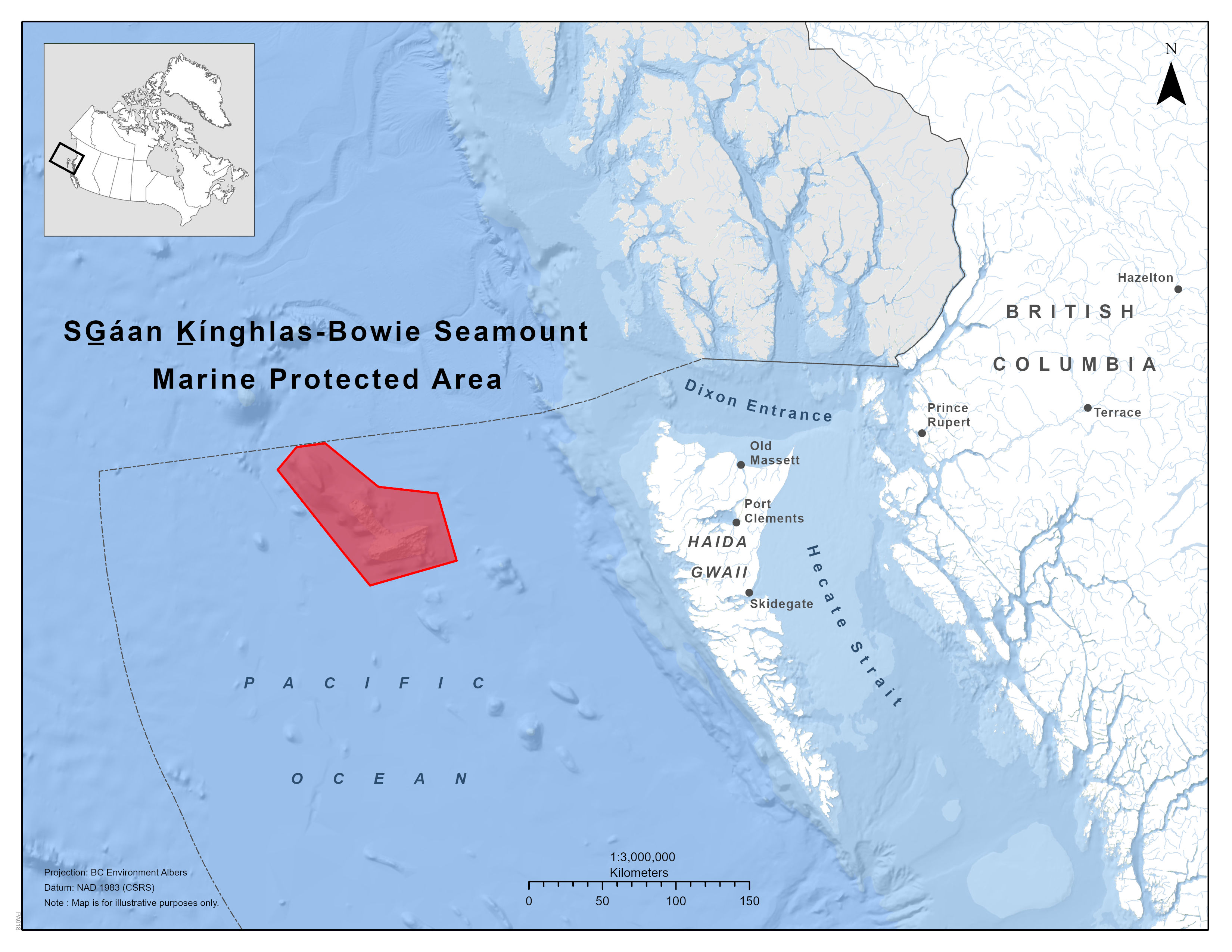
Map of SG̲áan K̲ínghlas-Bowie Seamount Marine Protected Area
Date of designation:
1997: X̲aads Siigee tl'a damaan tl'a k̲ing giigangs Haida Marine Protected Area
2008: Oceans Act MPA
Size:
6,103 km2
Contribution towards the marine conservation targets:
0.11%
Location:
This MPA is located 180 km west of Haida Gwaii in the Offshore Pacific Bioregion; Pacific Ocean.
Co-managed by:
Fisheries and Oceans Canada (DFO) and Council of the Haida Nation (CHN)
Acknowledgement:
This MPA is located within the territory of the Haida Nation.
Zones:
This MPA does not have any zones within its boundaries.
Key highlights
The name of the SG̲áan K̲ínghlas-Bowie Seamount was officially updated in the Geographical Names Board of Canada to reflect its cultural and ecological significance and connection to the Haida Nation.
CHN and DFO scientists produced videos and educational material promoting the 2022 Northeast Deep-Sea Diversity Expedition Project (NEPDEP).
In February 2023, CHN and DFO showcased SK̲-B MPA at the Fifth International Marine Protected Areas Congress (IMPAC5).
In March 2023, DFO’s Canadian Science Advisory Secretariat (CSAS) published the Science Advisory Report of the SK̲-B MPA Monitoring Framework. The SK̲-B MPA monitoring framework is a roadmap, providing a broad and high-level summary of options for monitoring the ecological conservation objectives.
In the spotlight: Benefits
Ecological
The SK̲-B MPA is home to three seamounts, including the SK̲-B seamount, which rises 3,200 metres to within 24 metres of the sea surface. Sharp depth transitions on the seamount slopes provide habitat for different species. The MPA has unique oceanographic phenomena that result in well-mixed, nutrient-rich water.
The SK̲-B MPA contains a unique community that brings together the species below, which do not exist in proximity elsewhere:
- open ocean species (for example, migratory whales)
- deep water species (for example, squat lobsters)
- shallow water species (for examples, mussels and kelp)
The relative shallowness of the SK̲-B MPA makes it susceptible to the impacts of fishing. To protect the sensitive ecosystems, the MPA is closed to all commercial and bottom-contact fishing.
Socio-cultural
In G̲aw Tlagée X̲aad kíl, the Old Massett Haida dialect, SG̲áan K̲ínghlas means “supernatural being looking outwards” (CHN and DFO 2019).
The area holds historical, spiritual and cultural significance to the Haida Nation. The MPA's namesake seamount is home to the supernatural being, SG̲áan K̲ínghlas.
Haida oral history refers to Haida ancestors gin siigee tl'a kaatl'aagangs coming out of the ocean at the beginning of time. Another oral history tells of 2 young siblings finding a puffin colony on SG̲áan K̲ínghlas at a time of lower sea levels and returning to their village to distribute puffin beaks and restoring their families' status. Some also believe that the seamount is the 2 headed stone frontal pole referred to in a Haida story about Chaan sGaanuwee (the one in the sea) recorded by the anthropologist and linguist John Swanton in 1905.
Economic
In addition to Haida knowledge and use over thousands of years, the SK̲-B seamount and surrounding areas have also supported other human activities like whaling, fishing, and research. Currently, the main human activities in the SK̲-B MPA are:
- scientific research
- monitoring
- vessel traffic
Other activities like marine tourism and recreational fishing occur infrequently. The SK̲-B MPA is a highly biodiverse ecosystem that acts as a refuge and nursery for flora and fauna, which may provide economic benefits outside of the MPA.
Education and outreach
Education and outreach activities are guided by the communications protocol and strategy that was developed by the SK̲-B Management Board to increase MPA awareness in 2020.
At IMPAC5, SK̲-B MPA was highlighted at the Indigenous Pavilion. CHN and DFO co-presented on the co-management relationship and the development and implementation of the SK̲-B MPA Management Plan. They presented on behalf of a collaborative scientific partnership on the lessons learned from monitoring the SK̲-B MPA. Overall, the MPA was featured in 4 presentations covering topics like research and monitoring, outreach, and co-management.
CHN is developing a curriculum incorporating X̲aad kíl and X̲aayda Kil (G̲aw Tlagée Old Massett and Hlɢ̲aagilda Skidegate dialects of the Haida language) for schools on Haida Gwaii to teach students about the cultural and ecological significance of SK̲-B and deep-sea ecosystems.
CHN and DFO scientists participated in an episode of Live It Earth, an online educational series, where they shared their knowledge of SK̲-B, deep-sea ecosystems and expeditions with students from Haida Gwaii and around Canada.
Research and monitoring
The CHN and DFO co-authored the SK̲-B MPA Monitoring Framework. It provides a high-level summary of options for monitoring the MPA's ecological conservation objectives and connects the conservation objectives outlined in the MPA management plan to monitoring indicators, protocols, and strategies. This allows DFO to select the most appropriate monitoring approach for a monitoring plan.
DFO scientists are investigating the oceanography of the SK̲-B seamount and the delivery of nutrients and larval benthic organisms. This will describe conditions driving the high biomass and biodiversity found on the seamount.
DFO scientist, Dr. Cherisse Du Preez, is co-supervising graduate student projects related to the MPA. These include:
- investigating how climate change will affect the distribution of invertebrates (Megan Davies)
- looking at the relationship between water chemistry and animal abundance (Pandora Gibb)
- monitoring cold-water coral and sponge diversity over time (Lindsay Clark)
Dr. Cherisse Du Preez also co-supervised Daniel Labbé, who defended a thesis exploring the differences in zooplankton populations among isolated seamounts (including SK̲-B).
A team of DFO scientists, led by Dr. Josephine Iacarella and supported by Dr. Anya Dunham, published a paper evaluating conservation area effectiveness across Canada's 3 oceans, which included the SK̲-B MPA. Another paper was published that applied and compared automatic identification system and flyover vessel tracking methods for estimating fishing in marine conservation areas in the Canadian Pacific, and a report was produced that examined how vessel tracking can monitor marine conservation area effectiveness.
Collaboration and partnerships
CHN and DFO scientists:
- co-developed a monitoring framework
- contributed to increased awareness of the SK̲-B by live-streaming work during an expedition and presenting on their findings at various talks/conferences (e.g. IMPAC5 and Live it Earth)
- designed and carried out long-term ecological monitoring expeditions to the SK̲-B MPA in 2018 and 2022
CHN and DFO scientists also produced 2 videos documenting the 2022 expedition, including surveys of the SK̲-B using remote operated vehicles. This expedition was also a UN Decade of Ocean Science and Challenger 150 endorsed activity.
For the Northeast Pacific Deep-sea Diversity Expedition to SK̲-B, CHN and DFO partnered with the:
- Nuu-chah-nulth Tribal Council
- Pacheedaht First Nation
- Quatsino First Nation
- Ocean Networks Canada
Surveillance and enforcement
CHN has been a partner in the Oceans Protection Plan pilot project for the Enhanced Maritime Situational Awareness System (EMSA) since 2019 to monitor vessel traffic. EMSA provides access to near real-time Automatic Identification System (AIS) data, through the Department of National Defense's fused satellite and terrestrial feed. In 2022, the SK̲-B Management Board supported the technical team's use of EMSA to monitor vessel traffic within the SK̲-B MPA and within 50 nautical miles of the SK̲-B seamount pinnacle.
Fishery Officers from local Conservation and Protection detachments and the Marine Patrol Program are not able to patrol this MPA because it is located far offshore; however, the Fisheries Aerial Surveillance and Enforcement Program was able to conduct numerous aerial surveillance patrols over the MPA for a total of 1.1 hours, with 2 commercial vessels detected during those flights.
The Marine Security Operations Center monitors the MPA using Radar Satellite II and analyzes acquisitions and detections with any AIS associations.
No fisheries violations were detected from audits to electronic monitoring data aboard fishing vessels. Future monitoring efforts will benefit from the approval to leverage the Dark Vessel Detection system in domestic waters as it will specifically target coverage of Pacific Region MPAs.
Management and governance
Foundational work
The management and governance of the MPA is based upon various foundational pieces of work. For example, a memorandum of understanding between the Haida Nation and Canada was signed in 2007 and established the structure of the SK̲-B Management Board. The terms of reference were agreed to in 2012, and further refined the roles, responsibilities and procedures of the SK̲-B Management Board. In 2019, the SK̲-B Seamount Gin siigee tl'a damaan K̲inggangs gin K̲'aalaagangs | Marine Protected Area Management Plan was published, outlining the guiding principles, goals and objectives of the MPA.
Recent progress
In 2023, the SK̲-B Management Board convened twice, in March and November.
DFO and the CHN are working to restructure the MPA Advisory Committee so that it is more efficient and can meet the consultative requirements of both parties.
Bi-weekly meetings occurred throughout 2023 with the SK̲-B Technical Team to support the governance and management of the MPA.
Looking to the year ahead
The full version of the SK̲-B MPA Monitoring Framework that was co-developed by DFO and CHN scientists is expected to be published in 2024.
DFO and CHN scientists are planning the next deep-sea expedition to the MPA for the summer of 2024, to revisit the long-term monitoring sites that were visited in 2018 and 2022.
Related link
- Date modified: