
MPA Network BC Northern Shelf Initiative (2023) Network Action Plan – a summary
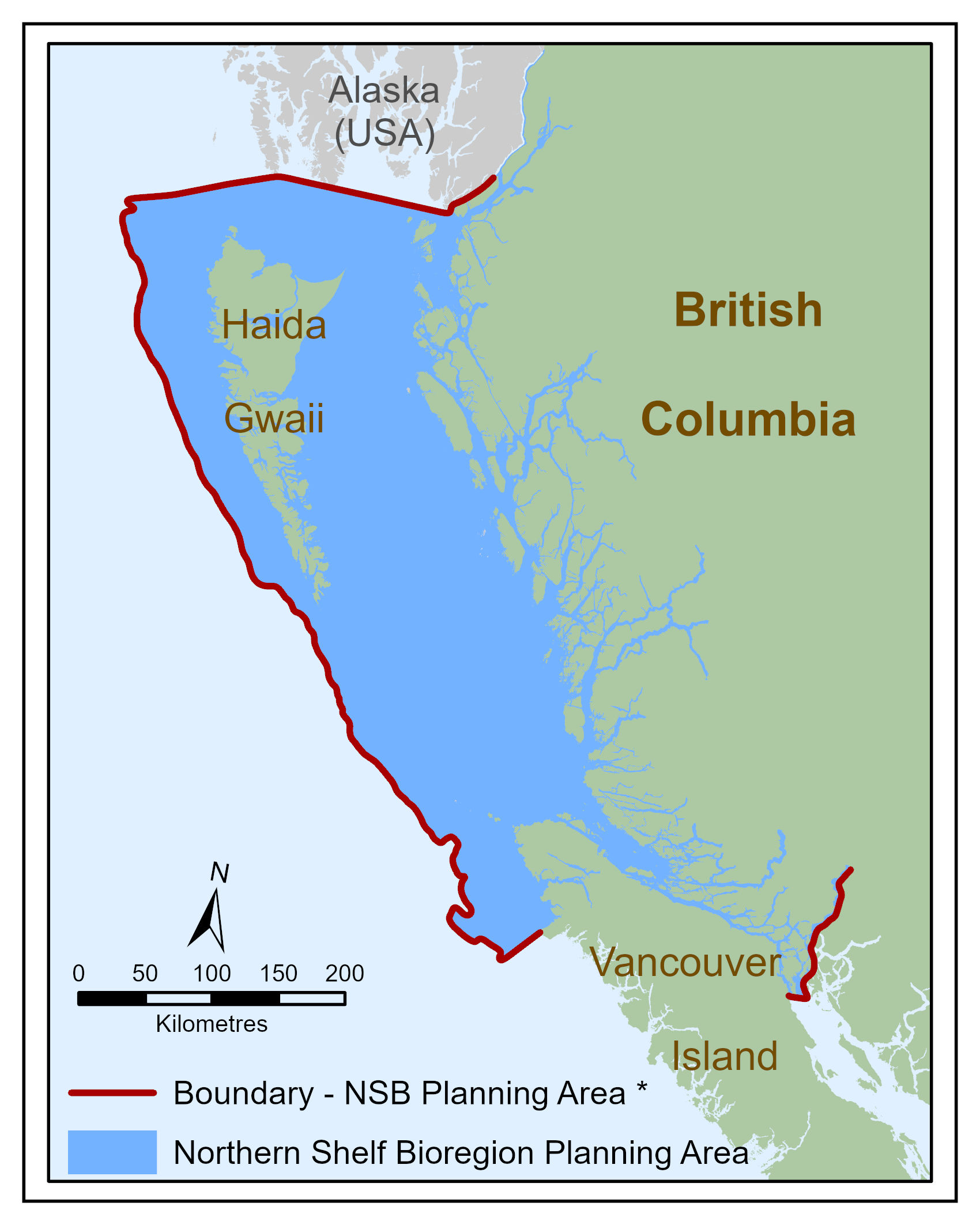
The west coast of Canada is a uniquely beautiful and special place where people and marine life co-exist within a vast landscape of rocky shorelines, kelp forests, deep fjords, open ocean, and intricate archipelagoes. Covering two thirds of coastal British Columbia (B.C.), from the middle of Vancouver Island to the Alaska border, the Northern Shelf Bioregion (NSB) is home to endangered whales, ancient corals, iconic salmon, sea birds, and many other ecologically, culturally, and economically important species (Figure 1). This abundance has provided for First Nations since time immemorial, and today supports coastal communities and marine activities such as fishing and aquaculture, tourism, coastal forestry, and marine transportation.
The Network Action Plan is the result of many years of planning to design a network of marine protected areas (MPAs) in the NSB (“the Network”). Over the coming months and years, it will help to guide the establishment and ongoing management of the Network to protect this unique marine area for present and future generations. This summary provides an overview of the proposed Network and the main components of the full Action Plan.
The NSB is under pressure. There are many contributing factors, including increasing demands for seafood, land and marine pollution, climate change, and other issues. In general, habitats and some species in the bioregion are experiencing worrying deterioration and declines. This in turn is affecting those who depend on the health of these ecosystems for their wellbeing. The MPA Network will be an important tool to help address these issues.
Used around the world to protect and conserve marine habitats and species, MPAs provide a wealth of ecological, cultural, social, and economic benefits. By carefully managing our ocean activities and providing for the recovery of areas from various stresses, MPAs help to preserve the ecosystems that we all depend on. While there are already over one hundred MPAs in the NSB, the Network will be more than the sum of these parts. By establishing new MPAs and integrating with other resource management approaches in the area, the Network will help to ensure that the NSB has the appropriate levels of protection required to remain healthy and prosperous long into the future.
What is an MPA?
Marine Protected Areas and MPA Networks are defined in the Canada-British Columbia MPA Network Strategy as follows:
Marine Protected Area
A clearly defined geographical space recognized, dedicated and managed, through legal or other effective means, to achieve the long-term conservation of nature with associated ecosystem services and cultural values.
Marine Protected Area Network
A collection of individual marine protected areas that operates cooperatively and synergistically, at various spatial scales, and with a range of protection levels, in order to fulfill ecological aims more effectively and comprehensively than individual sites could alone (Canada and B.C. 2014, 7).
In Canada, 'marine protected area' includes a broad range of protected area designations, such as National Marine Conservation Areas (NMCAs), provincial Marine Parks and Conservancies, and Indigenous Protected and Conserved Areas (IPCAs). Many such 'designation tools' will be included in the NSB Network to contribute towards conservation objectives.
For First Nations in the NSB, including those involved in the MPA Network process as Governance Partners, there are several reasons why important areas need protection designations. An MPA network will help to sustain and rebuild habitats and species populations that are vital to their ways of life, including food security. MPAs support First Nations' ability to maintain traditional marine management objectives and incorporate unique protection perspectives into new collaborative management regimes. In the Canadian context, a collaboratively developed and managed MPA network can also support principles of reconciliation that are shared by Indigenous, provincial, and federal governments (Akins and Bissonnette 2020).
The network planning process
First Nation partners, the Government of Canada, and the Province of B.C. have agreed to work together to advance MPA network planning for this area. The Action Plan supports implementation of the Reconciliation Framework Agreements (RFAs) between the Government of Canada, British Columbia, and First Nations to facilitate collaborative governance and management in the Northern Shelf Bioregion (NSB), including development and implementation of a network of MPAs in the NSBFootnote 1. It is consistent with direction provided by the Canada – British Columbia Marine Protected Area Network Strategy (Canada and B.C. 2014), the National Framework for Canada's Network of Marine Protected Areas (Canada 2011), and partner First Nations' marine plans, and supports efforts to create a national network of MPAs. It also supports ecosystem-based and adaptive management as set out in the Pacific North Coast Integrated Management Area Plan (PNCIMA 2017) and the Marine Plan Partnership (MaPP) sub-regional plans and Regional Action FrameworkFootnote 2.
The First Nations partners have likewise articulated visions of healthy marine ecosystems that support human wellbeing and cultural resilience and are managed with respect for the connections between people and the marine environment. First Nations are also working with Canada and B.C. to develop arrangements for collaborative governance and management.
Who is involved? A collaborative partnership for network planning and implementation
Oceans management in Canada is complex and requires a concerted effort by all governments to work together. Building on the precedents set by existing collaborative governance experiences and the strong relationships established through these initiatives, the MPA Network is being collaboratively planned and is expected to be implemented through collaborative governance and management agreements among the following Governance Partners:
First Nations governments
- Central Coast: Kitasoo Xai'xais, Heiltsuk, Nuxalk and Wuikinuxv First Nations, supported by the Central Coast Indigenous Resource Alliance (CCIRA)
- North Coast: Gitga'at, Gitxaala, Kitsumkalum, Kitselas, Haisla, and Metlakatla First Nations
- Haida Gwaii: Council of the Haida Nation
- North Vancouver Island: Mamalilikulla, Tlowitsis, and Wei Wai Kum First Nations, as represented by the Nanwakolas Council, and Kwiakah First Nation
Government of Canada
- Fisheries and Oceans Canada*
- Environment and Climate Change Canada
- Parks Canada
- Natural Resources Canada
- Transport Canada
Province of British Columbia
- Ministry of Water, Land and Resource Stewardship*
- Ministry of Environment and Climate Change Strategy
* Lead federal/provincial agency
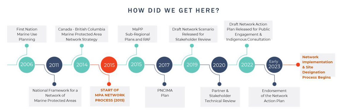
Formal planning for the MPA Network began in 2015 (Figure 2). The Governance Partners worked with experts and stakeholder groups to determine conservation objectives within the NSB and assess what was already protected by existing MPAs. The next step was to design a network that would effectively fill conservation 'gaps' while maintaining the cultural, economic, and recreational opportunities that people and communities in the NSB depend upon for their wellbeing and livelihoods. In 2019 a first draft of the proposed Network, known as 'Scenario 1', was produced. It mapped and proposed management details for over 370 potential zones within the Network, as well as objectives and guidelines for the Network as a whole. Scenario 1 underwent a year-long period of review by stakeholders and Governance Partner organizations. Significant efforts were made to incorporate feedback, and a revised Scenario 2 was produced in 2021
In the summer of 2021, work also began on the Network Action Plan, which describes the Network planning process, the proposed Network design and provides recommendations to support its implementation, governance, and adaptive management.
Long text version
Diagram showing timeline of planning stages from 2006 to 2023
- 2006 - First Nation marine use planning
- 2011 - National framework for a network of Marine Protected Areas
- 2014 - Canada - British Columbia Marine Protected Area newtork strategy
- 2015 - Start of MPA network process
- 2015 - MaPP sub-regional plans and RAF
- 2017 - PNCIMA plan
- 2019 - Draft network scenario release for stakeholder review
- 2020 - Partner and stakeholder technical review
- 2022 - Draft network action plan release for public engagement and Indigenous consultation
- Early 2023 - Endorsement of the Network Action Plan
- Moving forwards - Network implementation and site designation process begins
The proposed network: key measures and social outcomes
Long text version
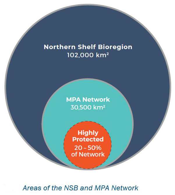
The Northern Shelf Bioregion is 102,000 km². Within the Northern Shelf Bioregion is the MPA Network, which is 30,500 km². Between 20% to 50% of the MPA Network is recommended to be targeted as highly protection.
Long text version
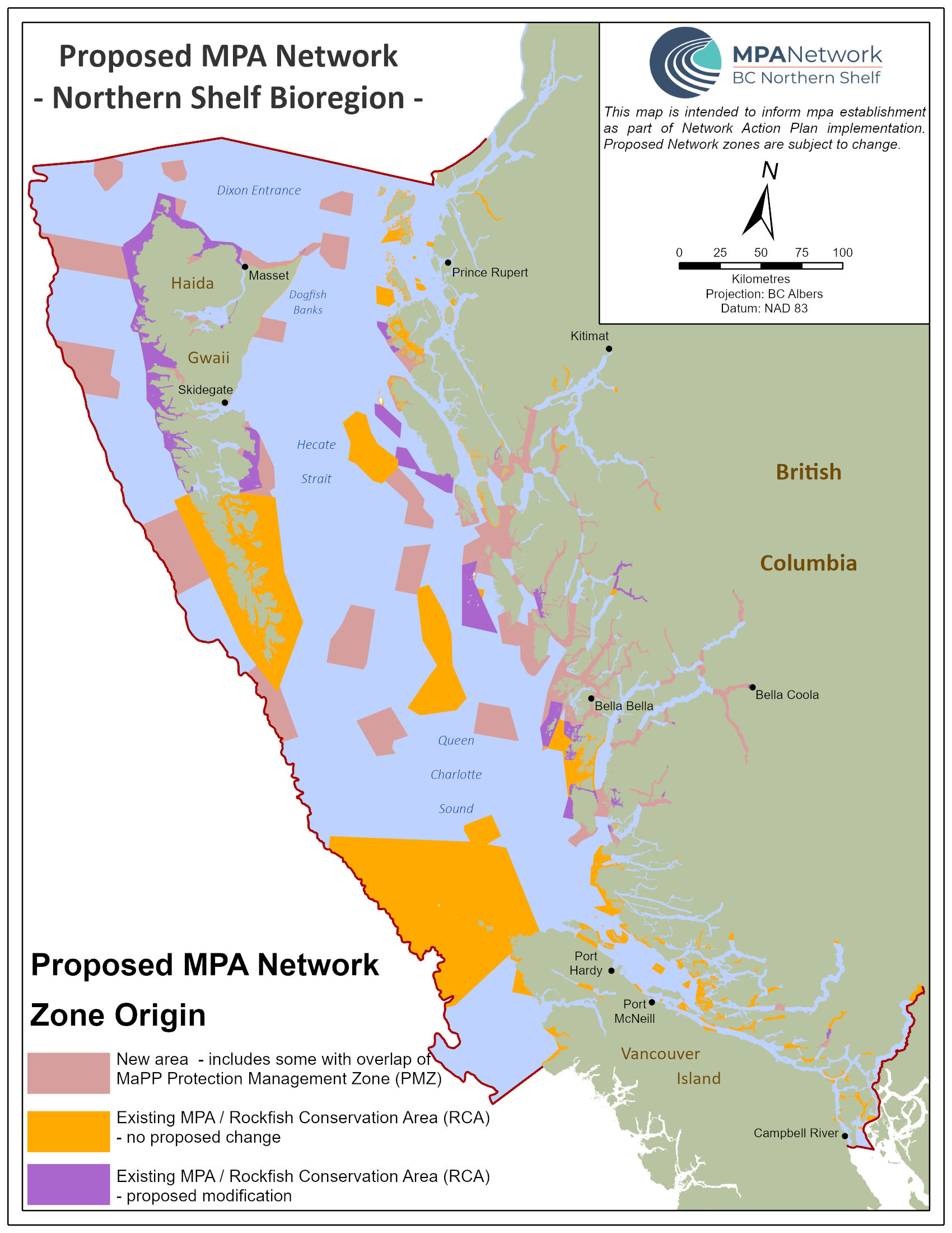
Proposed MPA Network - BC Northern Shelf Bioregion
This map is intended to inform MPA establishment as part of Network Action Plan implementation. Proposed Network zones are subject to change.
Kilometres Projection: BC Albers
Datum: NAD 83
- New area - includes some with overlap of MaPP Protection Management Zone (PMZ)
- Existing MPA / Rockfish Conservation Area (RCA) - no proposed change
- Existing MPA / Rockfish Conservation Area (RCA) - proposed modification
The proposed MPA Network includes 30,493km² (or about 30%) of the NSB. More than half of this area (about 62%) is comprised of existing MPAs,Footnote 3 with the rest made up of new areas (Figure 4), which include some areas zoned as Protection Management Zones (PMZs) in the MaPP plans. Between 20% and 50% of the proposed Network will be targeted for high protection, meaning that activities such as commercial and recreational fishing, aquaculture, and industrial activities would not be acceptable, whereas the remaining areas of the Network would allow for a selected mix of human uses while still meeting conservation objectives (Figure 3).
Using a combination of federal, provincial, and Indigenous protected area designation and governance tools, the Network is designed to protect and conserve key habitats, species, and areas of cultural importance to First Nations. While there is a trade-off between protection and human uses, the proposed Network addresses protection and conservation requirements for many of the area's most important features while minimizing economic costs. For example, it meets the 'representation targets' (how much of a feature we should try to include in the Network) for all habitats and many species.
The MPA Network is expected to result in many ecological, social, economic, and cultural benefits. It aims to protect and conserve ecosystems, enable sustainable marine economies, improve food security, and help us mitigate and adapt to the effects of climate change. The Network will also contribute to Canada and B.C.'s reconciliation efforts with participating First Nations as related to UNDRIP articles associated with governance and management of their territories. However, there will also be costs to establishing the Network. A wide range of economic and recreational activities overlap with the proposed Network and some of these activities have been identified as 'activities of concern' within the Network planning process. Risk assessments undertaken during implementation will identify any necessary mitigation measures to be applied by management, which could lead to impacts on existing activities. To minimize the future impacts the MPA Network, partners have used a wealth of socio-economic data to reduce overlaps with existing activities, engaged directly with many stakeholders, and are detailing the benefit and cost pathways that can lead to various outcomes from the proposed MPA Network.
Components of the Network Action Plan: a blueprint for network implementation
The Network Action Plan is a blueprint to guide implementation of a network of marine protected areas (MPAs) in the Northern Shelf Bioregion. It is comprised of 5 main parts:
- Introduction Chapter 1 introduces the purpose and components of the Action Plan and provides an overview of the Network development process.
- Proposed Network Chapter 2 provides an overview of the proposed Network design, including maps and key ecological, cultural, and socio-economic metrics.
- Operational Recommendations Chapter 3 contains detailed recommendations for implementing the Network, including potential legal designations for each MPA, and details on preliminary assessments of human activities. This chapter also outlines the implementation timelines for proposed MPAs.
- Network Governance and Management Chapter 4 describes the approach the partners are developing to enable implementation and future management of the Network and its constituent MPAs, including how stakeholders and other members of the public will be included. As outlined in this chapter, each MPA will require further prescribed steps for implementation and ongoing management depending on which designation tool is used.
- Detailed Profiles In Appendix 1, the Action Plan includes the full details of the proposed Network. In a series of 'profiles', the cultural and ecological values of areas within the Network are described, and the proposed boundaries, conservation objectives, and identified activities of concern for specific zones are presented.
In addition to the Action Plan itself, a series of compendium documents has also been developed to provide additional background information on the Network planning process, context, and analytical outputs.
Next steps: network implementation
The Network implementation phase begins following the endorsement of the Network Action Plan by the Governance Partners. The MPA Network zones have been organized into three implementation categories: Category 1 zones are targeted for establishment by 2025, and Category 2 zones by 2030. Category 3 areas require further discussion and planning and do not yet have timeframes for implementation. The relevant Governance Partners with management responsibilities for a given MPA will draw on the guidance in the Action Plan to determine further site-specific details and planning, as needed. Implementation of sites for all categories will include further refinement of the conservation objectives, the development of management plans, collaborative governance and management agreements, and continued stakeholder and First Nations engagement.
This webpage is not legally binding. It is not intended to define, create, recognize, deny, or amend any of the rights of the Governance Partners. While it is intended to inform decision makers, it will not be interpreted or implemented in a manner that fetters the decision-making authorities of any of the Governance Partners. This Action Plan does not define the legal status of the Crowns' rights or title or any particular Indigenous Nations' rights or title, or how those rights co-exist with each other or other Indigenous Nations. Further, the Action Plan is not to be used, construed, or relied on by anyone as evidence, acceptance or admission of the existence, nature, scope or content of any treaty or Aboriginal rights or title and Crown rights or title.
Related links
- Date modified: