
Public Report – Canada’s Oceans Now: Arctic Ecosystems, 2019
On this page
- Foreword
- 1 State of the Canadian Arctic Ocean
- 2 Sea Ice
- 3 Habitats and food webs
- 4 Seasonality
- 5 Ecosystem variability
- 6 Neighbourhood connections
- 7 Co-management
- 8 Conclusion
Document information
Illustrations by Karianne Blank
© Her majesty the Queen in Right of Canada, as represented by the Minister of Fisheries and Oceans Canada, 2019
Cat. No.: Fs23-549/1-2019E-PDF
ISBN: 978-0-660-33044-0
Foreword
Canada’s Oceans Now: Arctic Ecosystems
Canada’s Oceans Now reports are summaries of the current status and trends in Canada’s oceans. These reports are produced every four years, as part of the Government of Canada’s commitment to inform its citizens on the current state of Canada’s oceans.
Canada’s Oceans Now: Arctic Ecosystems provides new knowledge and known trends for marine areas of the Canadian Arctic. The report was generated from scientific and Inuit knowledge (Sidebar: Inuit Knowledge) and findings provided by Fisheries and Oceans Canada, Environment and Climate Change Canada, as well as academic, co-management, and Territorial contributors.
This report is based on key findings detailed in the Canadian Technical Report of Fisheries and Aquatic Sciences 3344, State of Canada’s Arctic SeasFootnote 1. The scientific report presents findings related to advancements in baseline understanding of marine ecosystems in the Canadian Arctic and observed ecosystem responses to changes in sea ice. Scientific and Inuit knowledge describe current status and trends about marine habitats, species and food webs, the seasonal cycle of events (seasonality), variability over time and location, and connections between ocean areas, including coastal areas. There are major gaps in understanding of marine environments and species in the Canadian Arctic. These gaps are highlighted in the report and will need to be filled for effective ecosystem management. Information will be updated in future reports, providing an ongoing picture of the status and trends of Canada’s Arctic marine ecosystems.
Inuit knowledge
The term Inuit knowledge is one of several terms used to describe the knowledge held by Inuit of the Arctic, and may also be referred to as traditional ecological knowledge (TEK), Indigenous knowledge (IK), and Inuit Qaujimajatuqangit (IQ).
This report uses the term Inuit knowledge, as it is used by territorial governments and is a familiar term in all Inuit communities in Inuit Nunangat.
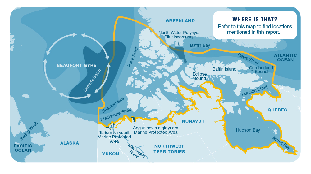
Long description
A map of the Arctic Ocean and northern Canada showing locations mentioned in this public report. The marine area outlined in yellow indicates where information was provided from for this report. to indicate the area where information in this report is covered.
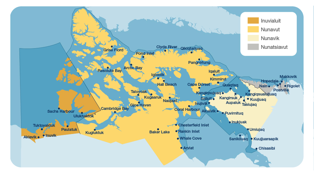
Long description
A map of Inuit Nunangat, the Inuit homeland, shows four Inuit regions in shades of yellow and grey along with their corresponding marine areas. The specific location of Canada’s 51 Arctic communities are shown in each of the Inuit regions.
1 State of the Canadian Arctic Ocean
The Canadian Arctic has the largest ocean area in the country. It spans 30 degrees of latitude from James Bay to the Polar Shelf, covering a wide range of ocean and coastal environments and their interconnected ecosystems (figure 1). Canada’s Arctic Ocean area would cover 41% of Canada’s land area, making it a huge area to understand and manage. The many islands and long coastlines are areas where sea ice can freeze securely to the land, an environment integral to Inuit survival and culture. No other polar region has as much of this type of land- attached ice. See figure 3 for more information about the immense scale and habitat types of the Canadian Arctic.
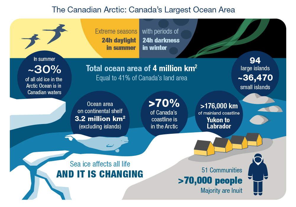
Long description
An infographic shows a simplified Canadian Arctic coastal scene with various facts written in blue bubbles and throughout. A human figure stands by a small community on the shoreline where a beluga swims by the coastal ice. Several islands are depicted in the water along with pieces of ice. The sky at top is split between day and night. The left sky has a sun and is yellow with birds flying, the right sky is black with northern lights and a moon.
- Extreme seasons with periods of:
- 24h daylight in summer
- 24h darkness in winter
- Total ocean area of 4 million km²
- Equal to 41% of Canada’s land area
- In summer ~30% of all old ice in the Arctic Ocean is in Canadian waters
- Ocean area on continental shelf 3.2million km² (excluding islands)
- >70% of Canada’s coastline is in the Arctic
- >176,000 km of mainland coastline Yukon to Labrador
- 94 large islands ~36,470 small islands
- 51 communities >70,000 people
- Majority are Inuit
- Sea ice affects all life and it is changing
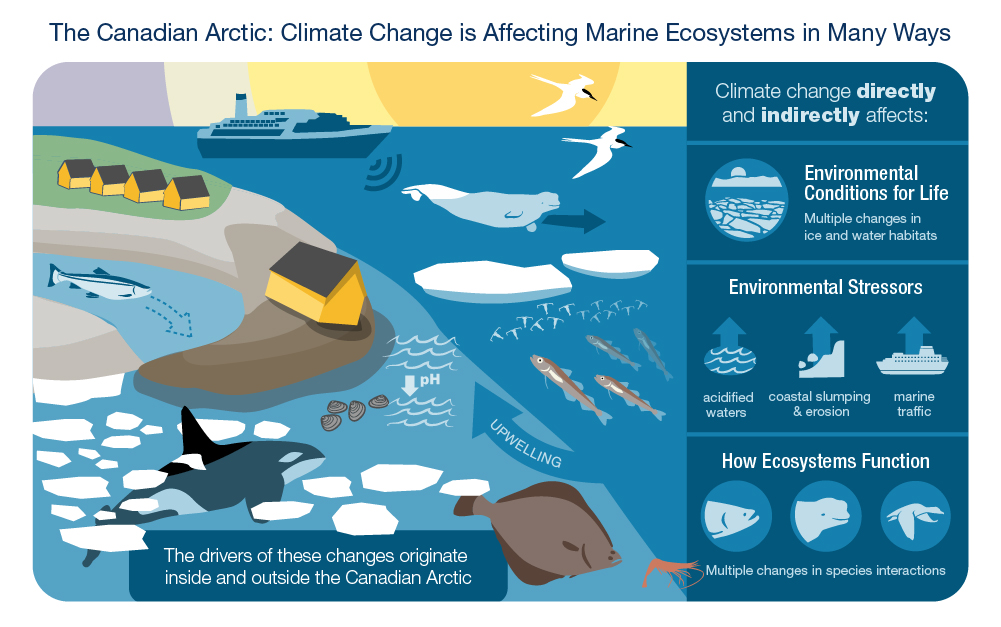
Long description
An infographic shows a simplified Canadian Arctic coastal scene showing the various types of climate change effects on ecosystems. A small community is depicted on the shore with one house slipping close to the waterline due to erosion along the coastline. An Arctic char is shown swimming from freshwater river to the ocean with eroded shoreline possibly blocking its path. A killer whale swims through several pieces of ice as it enters the Arctic. Four bivalves are shown near the shoreline beside a down-arrow indicating lower pH levels. A Greenland halibut and a shrimp are off the coast. Darker coloured water indicates deeper water. An arrow pointing upwards represents upwelling of deep water towards the coast. Several Arctic Cod are in the deep water by a group of plankton. In the distance a cruise ship is shown with noise symbols coming from it towards a beluga that is swimming away. Birds fly at the top of the scene with a sunset sky. A dark box floats over the Canadian Arctic coastal scene with text describing the direct and indirect impacts of climate change on the ecosystem. Icons that describe each piece of information are shown alongside the text.
- The Canadian Arctic: Climate Change is Affecting Marine Ecosystems in Many Ways
- Climate change directly and indirectly affects:
- Environmental conditions for life
- Multiple changes in ice and water habitats
- Environmental Stressors
- Acidified waters
- Coastal slumping and erosion
- Marine traffic
- How Ecosystems Function
- Multiple changes in species interactions
- The drivers of these changes originate inside and outside the Canadian Arctic
- Upwelling
- pH
Informing Canadian citizens on the current state of Canadian Arctic waters is a challenge. The Arctic, on a global scale, is changing but the type and speed of changes are not the same in all locations. Understanding the state of Canadian Arctic ecosystems is necessary to explain and manage present conditions and future changes. The state of an ecosystem describes conditions in a specific location— both the normal conditions and how they change over time. There is much to learn about in Canadian Arctic waters, and in many locations, there is limited information about changes in environments, food webs and biodiversity (Sidebar: Information Needed). Inuit knowledge provides the longest perspective over time. This valuable knowledge informs our understanding of coastal areas, especially where Inuit have lived for thousands of years (figure 2).
Identifying the status of Canadian Arctic waters is more challenging than in Canada’s other oceans. There has been little long-term, sustained scientific monitoring of ocean conditions and species in Canada’s Arctic. As a result, scientific evidence is limited to identify, explain and predict ecosystem changes across the Canadian Arctic. Inuit knowledge and scientific research document variable (fluctuating) conditions in the marine environment. Differences from year to year are normal, but changes— moving away from normal variation — are also occurring.
Observed and measured changes in Canadian Arctic waters are directly or indirectly linked to climate change (figure 4). Climate change also makes it possible for other stressors to affect marine ecosystems (Sidebar: Ecosystem Stress). Changes in sea ice— monitored by satellites since the 1970s — are a strong reflection of climate. Sea-ice changes affect every aspect of the ecosystem.
Species and environments do not respond independently to climate change or any other stressors. There is a strong interconnection between ecosystems— environments and the species who live there. This report identifies new knowledge and trends over the past five years, for ecosystem themes (figure 5) that are all affected by changing sea ice. The findings presented in this report are based on scientific and Inuit knowledge; both are needed to provide ecosystem-based information to support the management of the ocean and its resources. Figure 6 provides details about co-management and the need for more information to better inform the status of marine environments in the Canadian Arctic.
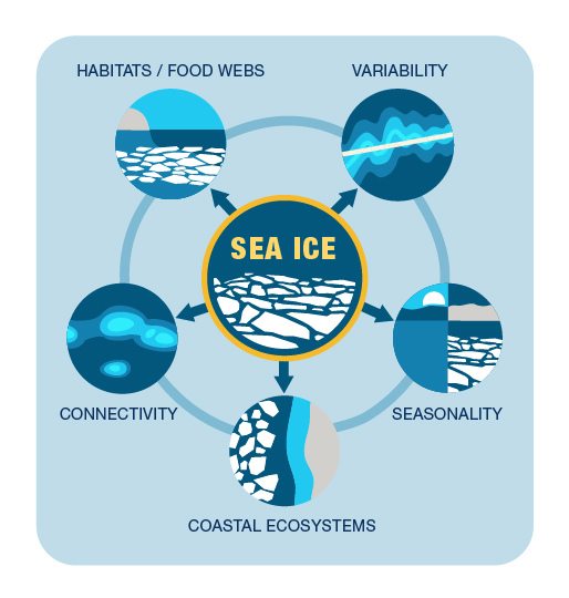
Long description
Several circles are shown in relation to each other. The circle in the centre represents sea ice and is bordered in yellow. Five circles surround the central circle with arrows pointing outwards towards them. Lines are shown between each of the outer five circles to indicate their relations. The outer circles show scenes representing each of the five themes described in this report: habitats/food webs, variability, seasonality, coastal ecosystems and connectivity. The visual graphic shows how sea ice is important for life and closely connected to all five themes.
- Sea ice
- Habitats/Food Webs
- Variability
- Seasonality
- Connectivity
- Coastal Ecosystems
Information needed
Some marine areas in the Canadian Arctic have never been studied. Effort to increase our knowledge of Canadian Arctic biodiversity— offshore fishes, for example— have documented new species. But are these species new to the Canadian Arctic or just found for the first time?
In many areas, information is collected very infrequently. For example, there may be more than 10 years between population surveys for marine mammals such as the Beaufort Sea beluga or the High Arctic walrus.
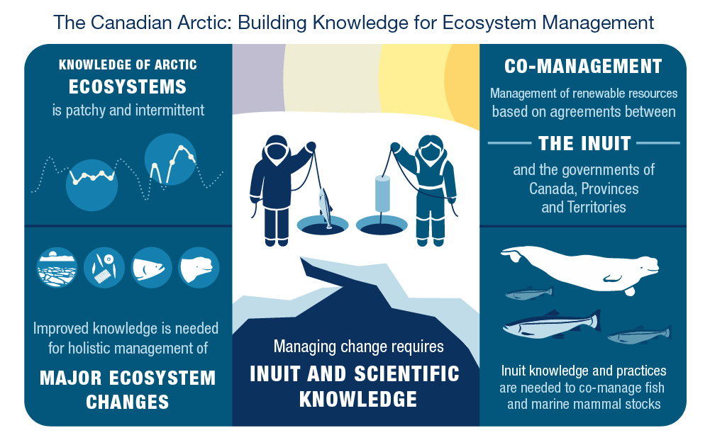
Long description
An infographic shows a simplified image of an Inuk and a scientist standing on sea ice near the water. There are two holes in the ice, one by each person. The Inuk is holding a line with a fish at the end over the ice hole while the scientist is holding a line with a sampling device over the other ice hole. A sunset sky is in the background. On either side of the central scene are blue boxes with text information and icons. At top left a simplified graph is shown, below left are four icons of simplified Arctic species and habitat. At bottom right there are icons of a beluga and Arctic char.
- The Canadian Arctic: Building Knowledge for Ecosystem Management
- Knowledge of Arctic ecosystems is patchy and intermittent
- Improved knowledge needed for holistic management of major ecosystem changes
- Managing change requires Inuit and scientific knowledge
- Co-management
- Management of renewable resources based on agreements between the Inuit and the governments of Canada, Provinces and Territories
- Inuit knowledge and practices are needed to co-manage fish and marine mammal stocks
Ecosystem stress
Climate change is the greatest human- caused stressor affecting the Canadian Arctic. It directly or indirectly affects other human-caused stressors in the marine environment, including shipping, the presence of microplastics and contaminants, natural resource development, and commercial fishing. Knowledge is needed on species and their environments to manage present and future effects of climate change and related stressors across the Canadian Arctic.
2 Sea ice
Sea ice is the single, most influential feature in Arctic marine waters. Sea ice is a component of Arctic ocean habitats that affects interactions between species that live there, as well as daily life in Arctic communities. Not all sea ice is the same. Two important categories are seasonal ice (forms and melts in one year) and multi-year, or old, ice (survives at least two summers). Sea ice more than 50 km from coastlines typically moves year-round (pack ice). Closer to shore, sea ice attaches to the land (land-fast ice) and generally stays fixed in place. Sea ice is an important travel route in the Arctic. It is used by community hunters to access the floe edge, the boundary of land-fast ice where pack ice has been swept away by wind.
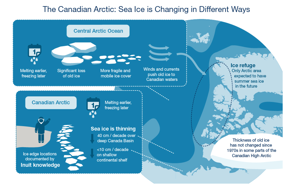
Long description
An infographic shows different ways sea ice is changing in the Canadian and Central Arctic. A map is shown in a circle of the high Canadian Arctic. At top left are icons indicating changes occurring in the Central Arctic Ocean including a calendar with dripping water, chunks of sea ice, turning into smaller more fragile sea ice, and arrows indicating winds and water currents that move the ice. An arrow points towards the top of the Canadian Arctic where an ice refuge is described. At bottom left are icons indicating changes occurring in the Canadian Arctic including a calendar with dripping water, an Inuk standing on the ice edge by several chunks of sea ice. Two down arrows are shown indicating thinning sea ice. At bottom right is a chunk of sea ice with text describing the thickness of old ice.
- The Canadian Arctic: Sea Ice is Changing in Different Ways
- Central Arctic Ocean
- Melting earlier, freezing later
- Significant loss of old ice
- More fragile and mobile ice cover
- Winds and currents push old ice to Canadian waters
- Canadian Arctic
- Melting earlier, freezing later
- Ice edge locations documented by Inuit knowledge
- Sea ice is thinning
- 40 cm/decade over deep Canada Basin
- <10 cm / decade on shallow continental shelf
- Ice refuge
- Only Arctic area expected to have summer sea ice in the future
- Thickness of old ice has not changed since 1970s in some parts of the Canadian High Arctic
Sea ice affects how the atmosphere interacts with the ocean. For example, strong winds do not create large waves if sea ice is present. Without the ice, waves can erode Arctic shorelines. The ice is a platform for polar bears and seals, and the ice itself is a home to diverse microscopic life including ice algae. Sea ice affects the movement of species and marine traffic, allowing or preventing mobility. It also controls the timing of annual events, such as when phytoplankton (microscopic plants in the water) grow, when Arctic Char feed in the ocean, or when some whales leave the Arctic for the winter. Sea ice affects life cycles, how energy is transferred through ocean food webs and how species interact with each other. When sea ice changes, ecosystems will change too.
Changes to sea ice in the Canadian Arctic are not the same in all locations, and each type of ice changes in different ways. Sea ice is thinning more rapidly over deep-water areas (Canada Basin) than over shallower areas (figure 7). There has been a major loss of old, multi-year ice around the center of the Arctic Ocean. However, because winds transport old ice from across the entire Arctic Ocean to the northern border of the Canadian Arctic, the overall loss of old ice has been lowest in the Canadian Arctic. Old ice can be found along the northern Polar Shelf and around islands in the Canadian High Arctic. New conservation efforts focus on Canada’s northern border, recognizing that in the future, it will likely be the last place in the entire Arctic to have sea ice during summer.
Key findings: Sea ice
- Atmospheric connection: Both natural climate patterns and climate change alter the atmosphere and the ocean. Both cause fluctuations and changes in sea-ice conditions.
- Open water: The period of open water is lengthening as seasonal ice clears or melts earlier and forms later.
- Thinning ice: 30 years of sea-ice data indicate that seasonal ice on continental shelves is responding differently to climate change than is multi-year ice over deep basins. Ice on the Beaufort Sea shelf is thinning less than 10 cm per decade compared to 40 cm per decade over the deep Canada Basin.
- Ice refuge: Winds are packing remaining old, multi-year ice into Canadian waters of the eastern Canada Basin and the northern Polar Shelf. This area is the only Arctic region expected to have summer sea ice over the next decades. This area may become a summer refuge for ice-associated species and for unique biodiversity.
- Floe edge location: Inuit knowledge from the Baffin Island area indicates that the location of the floe edge is changing. Over the past 10 years, the floe edge seems to be closer to shore.
3 Habitats and food webs
Habitats in Canadian Arctic waters are diverse, and include sea ice, water layers and the seafloor. These habitats vary between geographical locations. Seasonal and multi-year sea ice is important for species living on, in and beneath the ice (Box: Polar bears and Sea Ice Decline). Species also live on and in the seafloor. In some parts of the Canadian Arctic almost 60% of expected seafloor species are yet to be discovered. (Sidebar: Worm Discovery).
As sea ice and water in the Arctic and surrounding oceans change, they are affecting habitats and food webs in the Canadian Arctic. The water itself represents habitats that are different from east to west, and from shallow coasts and estuaries to deeper offshore waters and deep basins. Water habitat (the water column) is not the same from top to bottom. The ocean is made up of layers, each with different conditions and origins (figure 8). Winds and ocean currents can mix the layers and change habitat conditions, sometimes for just a short time (days to weeks). As water layers change, the ocean habitat changes, and this affects marine fishes and other species that prefer specific water layers and conditions.
At present, known changes to ocean water in the Canadian Arctic relate to chemistry and the supply of nutrients. In different areas of the Canadian Arctic, seawater has become more acidic over the last 10 to 20 years. While this “acidified” water is not harmful to people, the lower pH levels can damage shells of some species, snails for example, and may create a more stressful environment for fishes and invertebrates. More carbon dioxide (CO2) is entering the Arctic Ocean. More CO2 in the water combined causes higher acidification in the Canada Basin than elsewhere in the Canadian Arctic.
The consequences of changing ice and water conditions for food webs are not well known across different habitats. More open-water habitat means the marine food web may be supported by increased growth of microscopic plants in the water (phytoplankton) and less by those in sea ice (ice algae). However, changes in nutrient availability, especially nitrate — an essential nutrient used by phytoplankton— may support or limit increases in phytoplankton. With multiple changing conditions, it is not possible to say that phytoplankton is consistently increasing or decreasing, or to say that all marine locations in the Canadian Arctic are changing in the same way. In Cumberland Sound, algae in the water column are an increasingly important energy source for the food web, with less energy coming from algae in the ice. Diet studies of beluga, ringed seals, Greenland Halibut and Arctic Char from Cumberland Sound also indicate changes in the abundance and types of prey species available in the food web (Figure 9).

Long description
A simplified graphic shows ocean layers in the Canadian Arctic. Four boxes stacked vertically are shown in four separate shades of blue and textures at various depths. The bottom box is darkest and deepest showing centuries-old water below 3000 metres, above that sits the Atlantic layer from 350 to 3000 metres. Above that sits the Pacific layer from 75 to 350 metres. The top shallowest layer is the Arctic layer from 0 to 75 metres.
- Ocean Layers
- Depth
- 0 m Arctic
- 75 m Pacific
- 350 m Atlantic
- 3000 m Centuries-old water
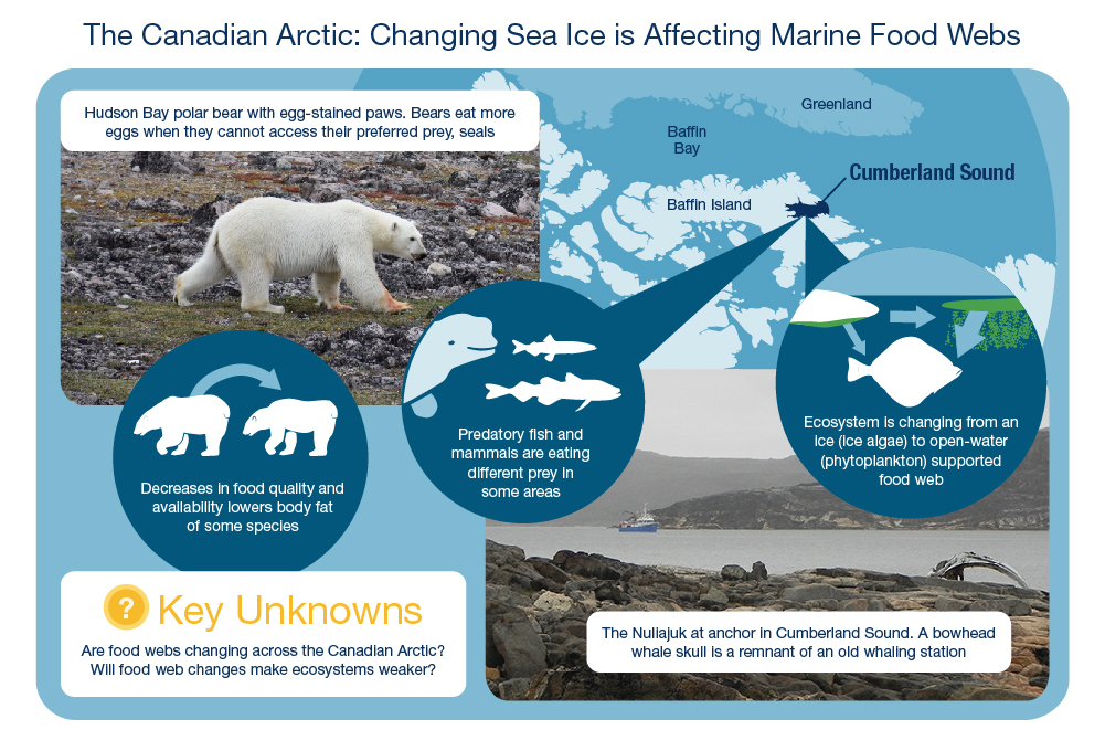
Long description
An infographic shows how changing sea ice is affecting marine food webs. A mixture of photos and simplified images are shown over a map of part of the Canadian Arctic. At top left there’s a photo from Hudson Bay of a polar bear with orange/yellow? (red would be blood?!)-stained feet from eating eggs with text describing the scene above it in a white box. Three large blue bubbles are in the middle of the infographic. The left bubble shows an icon of a healthy polar bear with an arrow pointing towards a skinnier polar bear showing a loss in body fat. The second bubble shows a partial icon of a beluga with a cod and a capelin. The third bubble shows icons of sea ice with green algae growing on the bottom as well as green spots in the open water representing phytoplankton. There is an arrow between the two types of algae indicating a shift from ice algae to phytoplankton. From the ice algae there is a thin arrow pointing to a halibut and a thick arrow points from the phytoplankton to the same halibut. , The simplified scene in the third bubble represents a changing food web. The second and third bubble both have arrows pointing to Cumberland Sound on the northeast end of the Arctic map. In the bottom right corner is a photo of the ship Nuliajuk in Cumberland Sound and a bowhead whale skull. In the bottom left corner there’s a white box with a yellow icon with a question mark in it representing “key unknowns”.
- The Canadian Arctic: Changing Sea Ice is Affecting Marine Food Webs
- Hudson Bay polar bear with egg-stained paws. Bears eat more eggs when they cannot access their preferred prey, seals.
- Greenland
- Baffin Bay
- Baffin Island
- Cumberland Sound
- Decreases in food quality and availability lowers body fat of some species
- Predatory fish and mammals are eating different prey in some areas
- Ecosystem is changing from an ice (ice algae) to open-water (phytoplankton) supported food web
- The Naliajuk at anchor in Cumberland Sound. A bowhead whale skull is a remnant of an old whaling station
- Key unknowns
- Are food webs changing across the Canadian Arctic?
- Will food web changes make ecosystems weaker?
Polar bears and the decline of sea ice
Almost two decades of research is showing the effects of climate change on the Arctic’s most charismatic top predator, the polar bear. Polar bears in western and southern Hudson Bay are in poorer condition due to the decline of sea ice and reduced access to sea ice and seals.
Worm discovery
In 2013, millions of tubeworms were discovered living on active mud volcanoes in the Canadian Beaufort Sea (280-740 metres water depth). The volcanoes, 600-1100 metres across and 30 metres tall, spew warm mud and gases, including methane. The worms have no eyes and no stomach. To survive they use gases from the volcanoes as an energy source (chemosynthesis), likely in partnership with bacteria that live in their bodies. This discovery represents the first— and only— known living chemosynthetic community in Canadian Arctic waters. The nearest similar community is in the Norwegian Arctic.
What else is waiting to be discovered in the Canadian Arctic?
Key findings: Habitats and food webs
Habitat changes
- Ocean chemistry: Surface waters in the Canada Basin are more acidic now than they were 20 years ago. This is linked to a prolonged (>15 years) clockwise rotation of surface waters in the area driven by wind from the most common direction.
- Upwelling: Water mixing that brings nutrients from deeper water to the surface layer is called upwelling. The number of upwelling events has doubled on the Mackenzie Shelf over the last 25 years. This is also linked to the prolonged clockwise rotation of surface waters in the Canada Basin.
- Nutrients: The layer of water from the Pacific Ocean holds most of the nutrients needed for phytoplankton growth in Canadian Arctic waters. This layer is typically found at a depth of 150 meters. Over the last 15 years, the Pacific layer has been pushed down in the central Beaufort Sea, and up in the shallower continental shelf of the Beaufort Sea. There is more phytoplankton growth where the nutrients are closer to the sunlight.
- More open water: Although satellite data show that, over a year, there is more phytoplankton growth because there is more ice-free water in the Canadian Arctic, some areas have less phytoplankton growth due to declines in nutrient availability.
- Availability of sea ice: The availability and stability of sea ice as a platform is decreasing. This is linked to skinnier polar bears and ringed seals in Hudson Bay. Consequently, polar bear populations are declining in Hudson Bay. Changes at the population level are not yet evident for ringed seals.
- Habitat use: The preferred habitat of fishes in offshore waters is closely tied to the depth of Atlantic or Pacific water layers in the Beaufort Sea and Baffin Bay. Key food web species such as Arctic Cod prefer transition zones between ocean layers. Consequently, changes in ocean layers are directly related to changes in ocean habitat.
Food web changes
- Diets: In the eastern and western Arctic, marine predators such as Arctic Char, Greenland Halibut, seals and beluga have flexible diets. In Cumberland Sound, the diet of marine predators has changed to include different fish species, e.g., capelin.
- Shifting energy sources: As a result of an increasing open-water period in Cumberland Sound, food web pathways are changing. Different marine predators are now eating similar things. More energy for the food web now originates from phytoplankton rather than the algae that grows in sea ice.
4 Seasonality
The Canadian Arctic has extreme seasonal changes — 24 hours of darkness and covered in ice in winter, and 24 hours of daylight and reduced ice cover in summer. Marine species and humans living in Canada’s Arctic have adapted to the yearly cycle. Coastal communities are in tune with seasonal changes. People know where and how to travel to hunting grounds and when to expect different fishes and marine mammals in their areas (Sidebar: Knowledge Inventory). But the yearly cycle of events is changing, and marine ecosystems are not always behaving as expected.
The main reason for seasonal changes in Arctic marine ecosystems is the shortening of the ice covered period. Sea ice is clearing or melting earlier in the year. This change affects the timing of lifecycle events (e.g. birthing, feeding, migration). The longer open-water period affects the ice algae and phytoplankton at the foundation of food webs (Box: The Ocean in Bloom). While these changes will likely affect the entire food web, it is not well known how individuals and species, as well as interactions between species, will be affected (figure 10).
The lengthening open-water period can benefit or harm fishes, marine mammals and birds, depending on their adaptability and interactions with other species. Many are important subsistence species for Inuit in Inuit Nunangat (figure 11). Species such as common eiders (sea ducks) can benefit by adapting to hatch their eggs just prior to ice-free conditions. Ducklings are then able to feed in open water just days after hatching, increasing their chance of survival. Over the last 20 to 30 years, marine mammals studied in the Beaufort Sea and Hudson Bay have responded differently to changes in the amount and timing of sea ice. Some studies indicate that the health of young bowhead whales has improved over time, but ringed seal and beluga may have experienced declines in health (Box: Ringed Seals in Hudson Bay). More years of research are needed to monitor how some marine mammal populations will continue to respond to the changing Arctic seasons.
Knowledge inventory
The close relationship between coastal communities in Nunavut and seasonal changes in the ocean are reflected in data from the Nunavut Coastal Resource Inventory— a project led by the Government of Nunavut to document Inuit knowledge on coastal and marine fish, marine mammal, bird, plant and invertebrate species. Nunavut communities are currently living with the consequences of changes in sea-ice conditions.
Long description
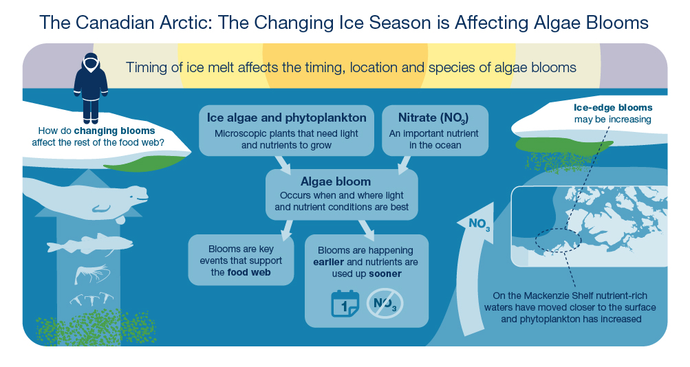
An infographic shows a simplified Arctic Ocean ecosystem scene. At left a human figure stands on the ice edge with text underneath them. Below the ice is a green patch of ice algae, below that is a simplified food web with an arrow pointing upwards towards the human figure. The food web consists of an icon of a beluga, an Arctic cod, a shrimp, plankton and phytoplankton. At the centre of the infographic are five shaded bubbles with text in them describing how algae bloom forms and how they are changing. Arrows are pointing from the top two text bubbles to a bubble in the middle to the bottom two bubbles. On the right side of the image there is another ice edge with green ice algae under the ice. A small map is shown which indicates where the Mackenzie Shelf is located with a circle and dashed lines pointing to the ice edge bloom and a piece of information related to nutrient levels. Beside the map there is an arrow pointing upwards towards the ice edge with the text “NO3” indicating movement of nutrient rich water to the surface.
- The Canadian Arctic: The Changing Ice Season is Affecting Algae Blooms
- Timing of ice melt affects the timing, location and species of algae blooms
- How do changing blooms affect the rest of the food web?
- Ice algae and phytoplankton
- Microscopic plants that need light and nutrients to grow
Nitrate (NO3) - An important nutrient in the ocean
- Algae bloom
- Occurs when and where light and nutrient conditions are best
- Blooms are key events that support the food web
- Blooms are happening earlier and nutrients are used up sooner
- Ice-edge blooms may be increasing
- On the Mackenzie Shelf nutrient-rich waters have moved closer to the surface and phytoplankton has increased
The ocean in bloom
Short-lived phytoplankton blooms are important events in Canadian Arctic waters. Many species coordinate their reproduction and feeding with the timing of the bloom. The timing and location of blooms are strongly controlled by sea ice and snow cover. Blooms at the ice edge can have different effects on nutrients and the food web depending on whether the ice edge is located over deep basin or shallower (continental shelf) areas.
Ringed seals and the decline of sea ice
With extremely early ice breakup, ringed seals are not able to complete their moult (loss and re-growth of body hair). The accompanying high ocean temperatures may make the seals too hot causing unusual behaviour that puts them at higher risk of polar bear predation. For example, a very warm year in 2010 resulted in poor ringed seal health in Hudson Bay. Seals experienced increased stress, giving birth to fewer pups in the following years.
Long description
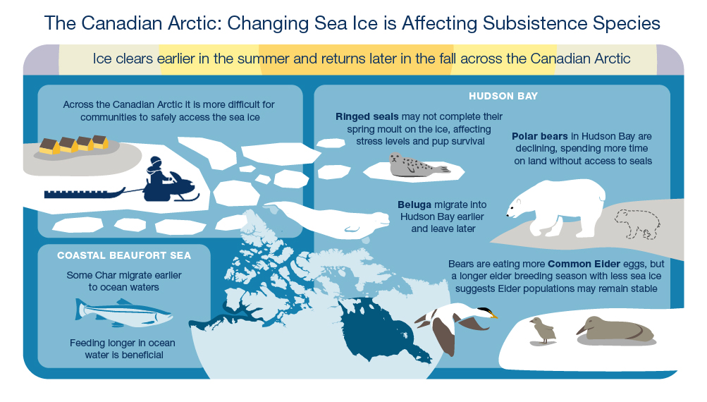
An infographic shows some examples of how the changing ice season is affecting subsistence species. Three boxes show three areas of impact with various icons and information in them. At top left a community is shown with a human figure driving a snow machine and a sled along the sea ice with many broken pieces of sea ice around them. At bottom left is a box on the Coastal Beaufort Sea with an icon of an Arctic char beside a central simplified map of the Canadian Arctic. The coastal Beaufort Sea is highlighted along the western coast in navy blue. At right is a box about Hudson Bay with an icon of a ringed seal on an ice floe beside a polar bear on the shoreline. Behind the polar bear is a baby polar bear that has disappeared. A beluga icon is shown in the water in the middle of the infographic. A male common eider is shown flying towards a piece of sea ice where a female eider and a baby are nesting. The central map of the Canadian Arctic shows a navy blue area highlighting Hudson Bay.
- The Canadian Arctic: The Changing Ice Season is Affecting Subsistence Species
- Ice clears earlier in the summer and returns later in the fall across the Canadian Arctic
- Across the Canadian Arctic it is more difficult for communities to safely access the sea ice
- Hudson Bay
- Ringed seals may not complete their spring moult on the ice, affecting stress levels and pup survival
- Polar bears in Hudson Bay are declining, spending more time on land without access to seals
- Beluga migrate into Hudson Bay earlier and leave later
- Bears are eating more Common Eider eggs, but
a longer eider breeding season with less sea ice
suggests eider populations may remain stable - Coastal Beaufort Sea
- Some Char migrate earlier to ocean waters
- Feeding longer in ocean water is beneficial
Key findings: Seasonality
Changes throughout the food web:
- Earlier blooms: In some places, the period of peak phytoplankton growth (blooms) is happening earlier. These blooms and the response of zooplankton grazers and larval fishes, dependent on coordinated feeding with blooms, have not been monitored over time.
- Nutrients used earlier: Earlier blooms, possibly occurring more frequently under the ice, can reduce the amount of nutrients available for later summertime phytoplankton growth. This will alter how and when energy is transferred through ocean food webs.
- Arctic Char migration: The migration of Arctic Char to ocean waters in the western Canadian Arctic is occurring earlier in the year due to earlier ice break-up along the coast. This allows the fish to feed longer in ocean water. There have been improvements in Arctic Char growth in some coastal areas of the Canadian Beaufort Sea.
- Seal moult: With extremely early ice breakup, ringed seals are not able to complete their moult making the seals more susceptible to disease and predation.
- Beluga migration: Over the last 25 years, a shrinking ice season in Hudson Strait has allowed beluga to migrate into Hudson Bay earlier and leave later.
Responses to seasonal changes:
- Individual decisions: Individual responses to changes in the timing of ice cover and open water affect how populations will cope with climate change. Survival of common eider ducklings is highest if hatching is timed to occur just prior to ice-free conditions in Hudson Bay.
- Species interactions: The lengthening open-water feeding season supports common eider breeding in Hudson Bay, including increases in the number of eggs laid. Producing more eggs helps offset increasing nest predation by polar bears who cannot access seals, which is their preferred prey. This demonstrates that changes in sea ice can have multiple effects on a species, potentially resulting in no overall change in a population.
5 Ecosystem variability
Environmental conditions in the Canadian Arctic differ from year to year and decade to decade. This is a normal characteristic caused by atmospheric changes. Patterns of winds and air pressure have direct effects on both the ocean and sea ice. These conditions can shift in long cycles, having anywhere between two and 20 years of higher-or-lower temperatures and more-or-less wind, for example. Understanding the range of this natural variability is key to distinguishing between the Canadian Arctic’s normal variable conditions, and new trends linked to climate change.
Satellite data provides 40 years of information about the presence of sea ice. Air temperature, atmospheric patterns and wind conditions have also been monitored in different Arctic regions over many years. From these long-term data, expected cycles of ocean currents are also known. For example, surface water layers spin in a large circle over the deep Canada Basin. This rotating water is called the Beaufort gyre. Atmospheric cycles normally cause the gyre to shift between clockwise and counter-clockwise rotations every five to 10 years. However, the Beaufort gyre has stayed in a clockwise rotation for the last 19 years (as of 2017). As a result, fresh water from rivers and ice melt has been accumulating in the gyre. There is now about 33% more fresh water stored in the gyre than in 2003. The accumulated fresh water creates a barrier to nutrients held in the deeper Pacific Ocean water layer (figure 8) and the fresher surface waters become naturally more acidic.
The natural variability of marine life in Canadian Arctic waters is not as well known. There is limited information about changes in populations over time, as well as changes in the distribution of individuals or species groups. Commercially harvested species, Greenland Halibut and shrimp, are studied every year in Baffin Bay and Davis Strait to understand the variability of these specific species. The populations are variable but stable overall (figure 12). Complete ecosystems, from phytoplankton to whales, can be very different for just one year (Box: A Different Year). Understanding if years with low Arctic Cod abundance or unexpected distributions of beluga are becoming more common is important for predicting future change.
Long description
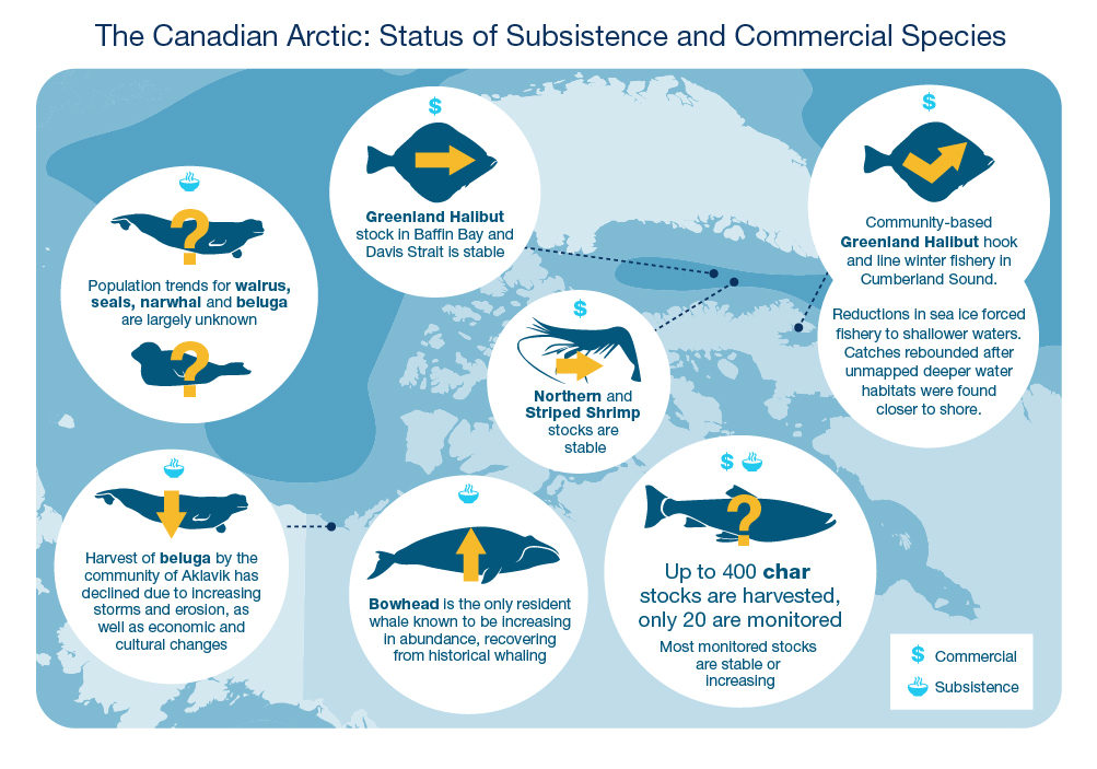
A map-based infographic shows the status of subsistence and commercial marine species in the Canadian Arctic. A map of the Arctic is in the background with seven white informational bubbles on top. Each bubble represents a different group of species, with arrows pointing to their specific location in the Canadian Arctic on the map behind them and an icon indicating if they are a commercial or subsistence species. In the bottom right corner of the infographic there is a legend that shows a dollar sign for a commercial species and a bowl for a subsistence species. The top left bubble shows a bowl icon, with icons of a beluga whale and a seal with yellow question marks as their population trends are largely unknown. At bottom left a bubble shows a bowl icon, with a beluga whale icon and a down arrow, a dashed line points to Aklavik on the map. The top middle bubble shows a dollar sign icon, and an icon of a Greenland Halibut with a forward-facing arrow and a dashed line points to Baffin Bay and Davis Strait on the map. The bubble in the middle of the infographic shows a dollar sign icon, and an icon of a shrimp with a forward-facing arrow indicating a stable abundance and a dashed line points to Baffin Bay. The bottom middle bubble shows a bowl icon and an icon of a bowhead whale with an upward arrow indicating increasing abundance in this species. At top right, a bubble shows a dollar sign icon, and has an icon of a Greenland Halibut with an arrow pointing down, then back up, indicating a rebound of a winter Greenland Halibut fishery. Lastly, the bubble in the bottom right corner shows both a dollar and bowl icons along with an icon of an Arctic char with a question mark indicating unknown information about stocks.
- The Canadian Arctic: Status of Subsistence and Commercial Species
- Population trends for walrus, seals, narwhal and beluga are largely unknown
- Harvest of beluga by the community of Aklavik has declined due to increasing storms and erosion, as well as economic and cultural changes
- Greenland Halibut stock in Baffin Bay and Davis Strait is stable
- Northern and Striped Shrimp stocks are stable
- Bowhead is the only resident whale known to be increasing in abundance, recovering from historical whaling
- Up to 400 char stocks are harvested, only 20 are monitored
- Most monitored stocks are stable or increasing
- Community-based Greenland Halibut hook and line winter fishery in Cumberland Sound
- Reductions in sea ice forced fishery to shallower waters.
- Catches rebounded after unmapped deeper water habitats were found closer to shore
- Commercial
- Subsistence
Some important habitats used regularly by marine mammals and other species can change dramatically from year to year. This includes the locations and sizes of polynyas, areas of thin ice and open water, where multiple species go to survive the winter (Box: Arctic Sanctuary). Variability in species abundances and distributions is closely related to habitat variability.
Knowledge of natural variability is necessary to describe the state of an ecosystem. Basic information is increasing for marine ecosystems in the Canadian Arctic, but trends over time remain scarce. With limited long-term data for Canadian Arctic waters, the information required to identify, explain and manage present and future ecosystem changes lags behind that of Canada’s other oceans (figure 13).
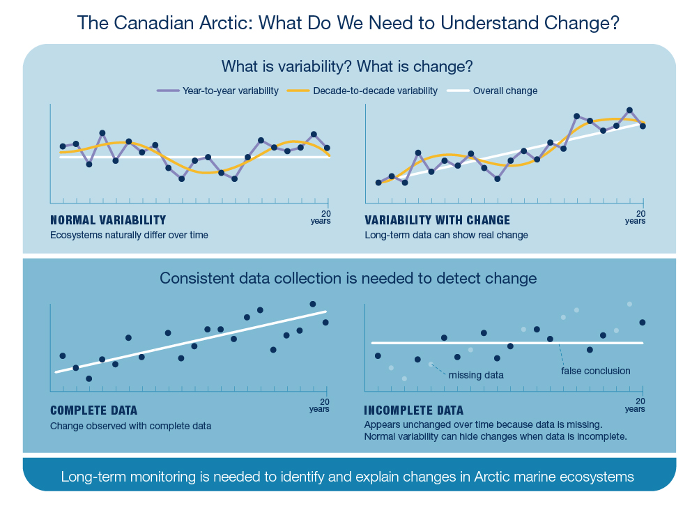
Long description
A graph based infographic describing what is needed to better understand change in the Canadian Arctic. Two graphs are shown at the top to describe normal variability and change. The normal variability graph have values that fluctuate up and down (blue line representing year-to-year variability) and a yellow line smoothly increases and decreases over a period of 10-years indicating decade-to decade variability. Overall, a white line through the data points is horizontal indicating no overall change over a period of 20 years. To the right is a second graph that shows variability with change. In this graph the line through the data points increases and an overall change is obvious despite fluctuations in the data points. The bottom panel shows two more graphs. On the left, a graph shows blue circles for data collected consistently over 20 years. With all the data present, a white line through the data shows an increasing trend. On the right, the same data is presented however some of the circles are grey, representing missing data. The white line is drawn through the blue available data and this time the line is horizontal and shows no increasing trend due to the missing data points. Text at the bottom of the figure describes the importance of long-term monitoring.
The Canadian Arctic: What Do We Need to Understand Change?
What is variability? What is change?
Year-to-year variability
Decade-to-decade variability
Overall change
Normal variability
Ecosystems naturally differ over time
20 years
Variability with change
Long-term data can show real change
Consistent data collection is needed to detect change
Complete data
Change observed with complete data
Incomplete data
Appears unchanged over time because data is missing. Normal variability can hide changes when data is incomplete.
Long-term monitoring is needed to identify and explain changes in Arctic marine ecosystems
Missing data
False conclusion
A different year
In 2014, there was a noticeable difference in the ecosystem of the Beaufort Sea. While there were much higher levels of phytoplankton than in previous years, Arctic Cod were not found in high numbers in the ocean layers that they typically prefer. Beluga were also distributed differently and the community of Ulukhaktok harvested more whales than ever before. Ecosystem-based studies are needed to understand variability throughout the environment and food web.
Arctic sanctuary
The North Water, Pikialasorsuaq, (figure 1) is a special place in Canada’s Arctic Ocean. It provides vital areas of open water for seabirds and multiple species of marine mammals. While this polynya has been recognized for many years for its abundant and life-supporting resources, environmental conditions here vary dramatically from year to year. Recent data suggest there may be a decline in resources at the foundation of the food web. The question is whether these changes are part of the natural variability of the polynya, or if it is an emerging trend, resulting from climate change.
Key findings: Ecosystem variability
Types of variability:
- Temperature: Water temperature near the seafloor in the middle of the Mackenzie Shelf has been variable since 1985. The long-term trend shows that this location in the Canadian Arctic Ocean is not getting warmer.
- Ocean currents: Surface waters in the Canada Basin spin (the Beaufort gyre) and the rotation is expected to change direction every 5 to 10 years. However, for the last 19 years (as of 2017), the gyre has been spinning in a clockwise direction. This changes the ocean habitat and decreases phytoplankton growth in that area.
- Habitats: Despite having high variability in ice coverage from year to year, the North Water (also known as Pikialasorsuaq) supports large populations of seabirds and marine mammals both in summer and winter.
- Marine mammals: The amount of variability in marine mammal populations remains largely unknown in the Canadian Arctic. Currently, the Bowhead is the only Arctic resident whale known to be increasing in numbers.
- Arctic commercial species: While commercially harvested stocks of Greenland Halibut and Striped and Northern shrimp have variable abundances year to year, populations are stable.
- Subsistence fisheries: The most complete information about population trends for Arctic Char and Dolly Varden subsistence fisheries are from stocks in the Western Canadian Arctic. Several of these stocks went through previous periods of decline. More recent assessments indicate stable or increasing trends in abundance.
Challenges of variability and change:
Detecting change in the environment and marine ecosystems of the Canadian Arctic is difficult due to large differences that occur naturally from year-to-year and decade-to- decade. Data of at least 20-years duration are typically needed to confidently identify trends against the background of normal environmental variability. Lengthy databases are generally not available and long-term approaches to monitoring are needed to explain changes in Arctic marine ecosystems.
6 Neighbourhood connections
The Canadian Arctic cannot be understood in isolation. Canadian waters are linked to the greater Arctic Ocean, and waters are received from both the Atlantic and Pacific Oceans. Sea ice in the Canadian Arctic may have travelled great distances, arriving from other Arctic regions. This means that drivers (natural forces) and stressors (human-caused) that affect Canada’s Arctic ecosystems, often originate in other oceans and other countries.
The Pacific Ocean water flowing into the Canadian Arctic carries the essential nutrients that control growth at the foundation of the food web. This Pacific water also delivers water that is more acidic than 20 years ago, which is contributing to ocean acidification in the Canadian Arctic. Monitoring the condition of water entering and exiting the Canadian Arctic is necessary to understand how ocean habitats are changing and how ocean connections could affect subsistence and commercial fisheries (figure 14).
Tracking migrations identifies long-distance connections between oceans and highlights how habitats are used at different times of the year (Box: Hotspots). It was recently discovered that Greenland Sharks can migrate from Jones Sound on Baffin Island to Northwest Greenland. New connections and details of migration routes continue to be discovered for migratory birds, marine mammals and fishes who rely on Canadian Arctic ecosystems. Movement patterns of Greenland Halibut, an important commercially harvested species, are currently being studied, with some fish from Cumberland Sound travelling as far as the Grand Banks and the west coast of Iceland.
Marine mammal migrations can be interrupted by sea ice. Inuit knowledge documents severe outcomes for marine mammals that cannot access needed connections between areas (Sidebar: Lost Connection). In contrast, the lengthening open-water period in the Canadian Arctic is now allowing for new and expanded connections to occur. For example, killer whales are more frequently entering the eastern Arctic— especially Hudson Bay. The increased presence of killer whales in the Canadian Arctic changes the behaviour of other whales as they try to avoid these aggressive predators (Box: Range Expansions). Understanding if new connections or existing connections will change or stay the same is vital in managing fish and marine mammal populations (e.g. freshwater-ocean connections for Arctic Char).
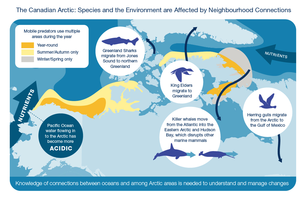
Long description
A map-based infographic shows how species and the environment are affected by neighbourhood connections. A map of the Arctic is in the background with several informational bubbles. Greenland is found the top of the map. In the top left corner is a legend showing orange, yellow and grey coloured boxes indicating year round, summer/autumn and winter/spring areas of use for mobile predators. Several sections are shown on the Arctic map in orange, yellow and grey colours to indicate changes in migration areas of mobile predators between seasons. At far left of the map, along the Pacific coast, is a dark blue arrow pointing northwards towards the Arctic Ocean indicating the movement of nutrients from the Pacific to Arctic Ocean. A blue bubble sits over Alaska with a dashed line pointed towards the Pacific arrow indicating movement of acidic Pacific water. At the top centre of the map a white bubble shows an icon of a Greenland shark with an arrow on the map showing migration from Jones Sound to northern Greenland. A white bubble in the middle of the map shows an icon of a King Eider with an arrow pointing northward to Greenland. An arrow is shown pointing downward from the Atlantic Ocean into the Eastern Arctic and Hudson Bay. Associated with it is a white bubble in the bottom centre of the map showing an icon of a killer whale chasing an icon of a narwhal with forward-facing arrows. At the far right of the screen is a white bubble with an icon of a herring gull with an arrow pointing southwards. In the far right corner of the map is a dark blue arrow pointing west showing the movement of nutrients from the Atlantic Ocean into the Arctic.
- The Canadian Arctic: Species and the Environment are Affected by Neighbourhood Connections
- Mobile predators use multiple areas during the year
- Year-round
- Summer/Autumn only
- Winter/Spring only
- Nutrients
- Pacific Ocean water flowing in to the Arctic has become more acidic
- Greenland sharks migrate from Jones sound to northern Greenland
- King Eiders migrate to Greenland
- Killer whales move from the Atlantic into the Eastern Arctic and Hudson Bay, which disrupts other marine mammals
- Herring gulls migrate from the Arctic to the Gulf of Mexico
- Knowledge of connections between oceans and among Arctic areas is needed to understand and manage changes
Lost connection
Connectivity is essential for the survival of many marine species in the Canadian Arctic. The loss of connectivity can be detrimental to individuals and populations. The most extreme example is the entrapment of whales in sea ice before they can leave at the end of summer. It is not known how common entrapment events are, but in 2008 and 2015, two large entrapment events were fatal for hundreds of narwhal from the Eclipse Sound stock. There have also been community reports of fatal entrapments of beluga and killer whales.
Range expansions
In recent years, species that were once rare in Canadian Arctic marine ecosystems are now becoming more prominent— potentially overlapping with Arctic species for prey and habitat. Although Pacific Salmon, killer whales and harp seals are not new to the Arctic, their numbers and locations are increasing. Community-based observations and research helps understand the effects of these range expansion on other marine mammals and local char species.
Arctic hotspots
Tracking the movement of individual marine species reveals the amazing distance they cover and provides insights into how they interact with sea ice and other species. Tracking information about fishes, marine mammals and birds offers a new view of how the Canadian Arctic operates as a collection of connected neighbourhoods. The information is identifying Arctic hotspots— locations that are used frequently and repeatedly by multiple species. They are important areas of energy exchange within Arctic marine food webs and represent locations where energy is brought into or removed from Canadian Arctic waters.
Key findings: Neighbourhood connections
Discovering species connections:
- New connections have been discovered:
- The migration of Greenland Sharks to northwest Greenland
- Greenland Halibut movements to shallower waters in fall
- Individual Dolly Varden char are travelling farther offshore on the Mackenzie Shelf in summer than previously known. They are not restricted to nearshore waters.
- Knowledge of marine fish movements is informing management strategies for harvested species (e.g., Greenland Halibut, redfishes) and conservation strategies for rare species and at-risk populations (e.g., wolffishes). In contrast to other species, the movement patterns of most marine fishes in the Canadian Arctic are not directly affected by sea ice. Instead, their movements respond to water temperature and the distributions of other species.
Changing connections:
- Pacific Ocean connection: Pacific water flowing into the Arctic via the Bering Strait has become more acidic, highlighting the connectivity of stressors between oceans.
- Habitat connections: Tracking studies of numerous mobile marine predators have found distinct ecosystem hot spots in summer-fall versus winter-spring. Such data reveal how connections among habitats can guide conservation efforts.
- Killer whale expansion: Reduced sea ice is enabling a greater presence of killer whales in the eastern Arctic and Hudson Bay, where they prey upon and disrupt other marine mammals (e.g., bowhead, narwhal, beluga, seals).
- Community connections: Connections to sea ice are critical for hunting and other land use activities in all coastal Arctic communities. This includes commercial fishing for Greenland Halibut in Cumberland Sound. Changing access to sea ice has become a serious issue of safety, food security and cost for Inuit.
- National and international connections: The extended ice-free season enables an increase in marine traffic in the Canadian Arctic — especially cruise ships and pleasure craft. The increased frequency and extended season of vessel travel may increase noise in the marine environment in some locations.
7 Co-management
Coastal waters of the Canadian Arctic are integral to Indigenous survival and culture. Canadian Arctic communities rely on coastal waters and adjacent areas for subsistence and economic opportunities. The protection of fish and marine mammal stocks, and the habitats that support them, is based on comprehensive land settlement agreements that include co-management boards to manage fisheries and wildlife. Co-management processes vary across the four Inuit land claims regions of Canada (Inuvialuit Settlement Region, Nunavut, Nunavik and Nunatsiavut), collectively known as Inuit Nunangat (figure 2). The use of both Inuit and scientific knowledge is critical in addressing change in Canadian Arctic coastal ecosystems (Box: Knowledge Integration).
In the western Canadian Arctic, the erosion and collapse of thawing coastline and inshore (delta) areas interrupts access to the coast for both fishes and people (figure 15). In the last 20-30 years, erosion rates have more than doubled in many regions of the Beaufort Sea coast.
The changing coastlines support different groups of fish. Understanding interactions between freshwater, coastal marine and anadromous (fish that move between fresh waters during the winter and coastal areas in the open-water season) species is important for protecting and managing subsistence species. However, basic knowledge is needed about their growth and the habitats they use throughout the year.
Information collected from current and past community harvesters improves understanding of coastal fish characteristics and catch rates. Community-based and community-led programs, as well as collections of Inuit knowledge, provide new and historical information about coastal areas. Inuit knowledge describes the increased presence of some species (capelin and killer whales for example), variability of coastal ice conditions and changing seasonal patterns of species in recent decades (Box: Community Monitoring). Community fishers, specifically in the western Arctic, are monitoring an increased occurrence of Pacific Salmon. Although these salmon are being found in coastal areas of the western Canadian Arctic, it is not yet known if they are able to reproduce there and colonize the northern part of their range.
Community monitoring
Community-based and community-led programs operate across the Canadian Arctic, collecting data and samples for a wide range of species, including beluga, seals, salmon, and chars. Data are often collected as part of traditional fishing, harvest and travel activities. Harvest data inform stock assessments and reflect harvest choices of community members. Inuit knowledge from Inuvik, Tuktoyaktuk and Paulatuk has improved ways to monitor beluga health in the Tarium Niryutait Marine Protected Area.
Knowledge integration
The availability and application of Inuit and scientific knowledge is essential for management decisions in the Canadian Arctic. In the Inuvialuit Settlement Region, this information was needed to make decisions about whale watching in the Beaufort Sea and fishing activities along the new Tuktoyaktuk highway. The co-development of knowledge which draws on a wide spectrum of Inuit and scientific knowledge is needed to support decision making by co-management boards.
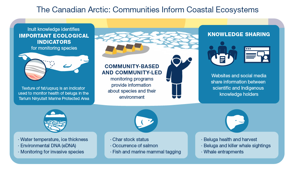
Long description
An infographic shows information on how communities inform coastal ecosystems. Two coloured informational boxes are laid out on either side of a simplified coastal Arctic scene. The box at left shows an icon of a beluga whale with a zoomed-in section showing the fat layer under the animal’s skin. In the centre of the infographic is a scene with a coastal Arctic community and a human figure waving from the sea ice. The box at right shows an icon of three people sitting at a round table with a report and an icon of a computer screen with a person and a speech bubble. At the bottom of the infographic are three icons and accompanying informational boxes. The icon at left is a simplified Arctic coast and sunset with sea ice. The central icon is a fish head and the far right icon is a beluga head.
- The Canadian Arctic: Communities Inform Coastal Ecosystems
- Inuit knowledge identifies important ecological indicators for monitoring species
- Texture of fat/uqsuq is an indicator used to monitor health of beluga in the Tarium Niryutait Marine Protected Area
- Community-based and community-led monitoring programs provide information about species and their environment
- Knowledge Sharing
- Websites and social media share information between scientific and Indigenous knowledge holders
- Water temperature, ice thickness
- Environmental DNA (eDNA)
- Monitoring for invasive species
- Char stock status
- Occurrence of salmon
- Fish and marine mammal tagging
- Beluga health and harvest
- Beluga and killer whale sightings
- Whale entrapments
Key findings: Co-management
- Shorelines: As frozen land melts and environmental conditions (e.g., air temperature, storms, winds, rains) change, shorelines in the western Canadian Arctic are collapsing and coastal erosion is accelerating. Shoreline change affects migratory and coastal fish habitat and releases land-based nutrients as a possible energy source for marine food webs.
- Fish monitoring: New information is emerging from community-based monitoring on nearshore movements and distributions of anadromous and coastal fishes. Communities are also monitoring the increase of Pacific Salmon at the northern end of their habitat in the western Canadian Arctic.
- Environmental monitoring: Community-based monitoring originally focused on culturally important species like Arctic Char and beluga. This monitoring continues and recently programs have expanded to include environmental observations, such as water temperature, salinity, and ice thickness.
- Indicators for monitoring: Inuit knowledge has identified measures of beluga health and condition used as part of monitoring programs in the first Canadian Arctic marine protected area, the Tarium Niryutait Marine Protected Area.
8 Conclusion
State of Canadian Arctic marine ecosystems
Knowledge of marine ecosystems in the Canadian Arctic is increasing, yet basic information for some areas is absent. Scientific and Inuit knowledge is needed to better understand year-to-year differences and changes over time. It is expected that entire Arctic marine ecosystems will continue to be affected by sea-ice variability and change. A holistic approach to ocean monitoring is needed to detect and explain changes, supporting the management of marine ecosystems in the Canadian Arctic.
- Date modified: