
Regional guidance on measures to protect corals and sponges during exploratory drilling - Canada-Newfoundland and Labrador Offshore Area
On this page
- Protect corals and sponges
- Guidance responding to regulatory requirements and Government of Canada policies
- Seabed Investigation Survey
- Visual survey
- Avoidance protocols and mitigations
- Redirection of drill cuttings
- Other mitigations in consultation with the C-NLOPB and DFO
- Follow-up and monitoring
- Enhanced measures in Other Effective Area-based Conservation Measures (OECMs)
- Outcomes
Protect corals and sponges
Corals and sponges play important ecological roles in deep-sea environments, such as offshore Newfoundland and Labrador, because they:
- provide large and small 3-dimensional complex habitat structures
- may act as hotspots for the cycling of organic nutrients, promoting primary productivity in upwelling areas
- are positively correlate with areas of high fish species richness
- provide habitats for feeding, resting, predator avoidance and nurseries for marine species
Potential impacts on corals and sponges from exploratory oil and gas activities may include:
- mortality
- breakage and other physical damage
- reduced abundance/density
- changes in health (e.g. ability to feed), and
- loss of habitat for other species
Guidance is not meant to be prescriptive, but rather provides transparency on expectations by outlining a process for proponents to meet regulatory and policy requirements and providing certainty for industry. The Canada Newfoundland and Labrador Offshore Petroleum Board (C-NLOPB) will continue to issue authorizations for exploratory drilling, with expert review, advice and recommendations from Fisheries and Oceans Canada (DFO). Guidance will facilitate DFO’s advice/recommendations to C-NLOPB concerning coral/sponge protection both inside and outside Other Effective Area- based Conservation Measures (OECMs) through enhancing the:
- Pre-drill Seabed Investigation Survey
- avoidance protocols
- mitigation options
- follow-up and monitoring
Exploration activities will be assessed on a site-specific basis.
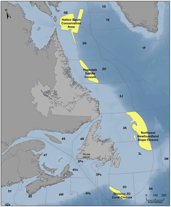
Other Effective Area-based Conservation Measures (OECMs) with coral and sponge conservation objectives in the Canada-Newfoundland and Labrador Offshore Area.
Description
A map showing the land masses of Newfoundland and Labrador, as well as the surrounding Atlantic ocean. Marine refuges are outlined and labeled; from north to south these refuges are:
- Hatton Basin Conservation Area
- Hopedale Saddle Closure
- Northeast Newfoundland Slope Closure
- Division 3O Coral Closure
Guidance responding to regulatory requirements and Government of Canada policies
Conditions of Environmental Assessment decision statements as described in exploration drilling projects assessed under the Canadian Environmental Assessment Act (2012).
The Impact Assessment Agency of Canada (IAAC) Regulations Respecting Excluded Physical Activities (Newfoundland and Labrador Offshore Exploratory Wells) to improve reviews of exploratory drilling projects in the Newfoundland and Labrador offshore (2020). These regulations require Seabed Investigation Surveys and that measures be taken to avoid and/or minimize impacts on aggregations of corals and sponges in OECMs.
The Government of Canada’s 2022 Marine OECM Guidance reflects existing federal marine OECM Protection Standards [2019] and Convention on Biological Diversity direction on OECMs [2018]. In OECMs, including marine refuges, DFO will continue to use a scientific, risk-based approach for prohibiting or allowing industrial activities, including oil and gas exploration. Existing and proposed activities will be assessed on a case-by-case basis to ensure risks to the OECM’s biodiversity conservation benefits have been avoided or mitigated effectively before they can proceed. OECMs that protect corals and sponges provide biodiversity conservation benefits directly to those species, as well as to diverse populations of other related species.
This guidance considers:
- best available scientific information and advice
- international best practices
- regional industry practices
- feedback from interested parties
It takes a balanced approach to maintain high levels of environmental protection during exploratory drilling programs. This guidance is an evergreen document and can be revised in response to new science, experience with regional projects, and evolution of best practices.
Seabed Investigation Survey
The Seabed Investigation Survey is a visual survey of sufficient quality and quantity to identify corals and sponges to the functional group level, and should include:
- Drill Center Survey Area based on 6.5 mm Predicted No Effects Threshold (PNET) or a standard minimum 200 m X 200 m area
- modeling of the drill cuttings dispersion area based on 1.5 mm PNET (Figure 2, grey).
- if applicable, anchor survey with 50 m buffer
- 8 Radial survey transects (Figure 2, orange) based on 1.5 mm PNET, plus 10% guardrails to account for model uncertainty
- modeled survey transects (Figure 2, blue)
- length based on the widest portion of the dispersion model
- transects same length and centered on dispersion model spaced at increasing intervals away from drill center
- buffer of 100 m radius (or larger based on extent of 6.5 mm PNET) added around the Drill Center Survey Area to account for:
- well relocation
- loss of survey coverage
- surveys at reference sites outside of modeled dispersion area

Pre-drill seabed investigation survey design – outside OECMs. For illustrative purposes only; survey extent, radial length etc. will be based on project specific modeling.
Description
The drill centre is surrounded by a box representing the drill centre survey area, in which drill cuttings are expected to accumulate to a thickness of at least 6.5 mm. This box is nested within a larger box representing the seabed survey buffer. There are also 8 radial transects originating at the drill centre and fanning out like spokes on a wheel. These transects are spaced 45 degrees apart from one another. South of the drill centre is a dark plume representing the area in which drill cuttings will accumulate to a thickness of at least 1.5 mm, as predicted by the drill cuttings dispersion model results. Running perpendicular to the model plume are 10 model survey transects which span the full width of the model plume and are capped on each end by additional guardrails. The model survey transect furthest from the drill centre is located just outside the model plume and is labeled as a potential reference site.

Pre-drill seabed investigation survey design – inside OECMs. For illustrative purposes only; survey extent, radial length etc. will be based on project specific modeling.
Description
The drill centre is surrounded by a box representing the drill centre survey area, in which drill cuttings are expected to accumulate to a thickness of at least 6.5 mm. This box is nested within a larger box representing the seabed survey buffer. There are 16 radial transects originating at the drill centre and fanning out like spokes on a wheel. These transects are drawn in pairs spaced 10 degrees apart from one another, with 35 degrees between each pair. A highlighted box at the top of the schematic indicates that this is twice the number of radial transects, compared to the survey design for outside of OECMs. South of the drill centre is a dark plume representing the area in which drill cuttings will accumulate to a thickness of at least 1.5 mm, as predicted by the drill cuttings dispersion model results. Running perpendicular to the model plume are 10 model survey transects which span the full width of the model plume and are capped
Visual survey
Pre-drill visual survey is a requirement but may be used in conjunction with other methods
- data collected along entire transects to identify coral and sponge functional groups
- conducted with equipment that produces data of sufficient quality and quantity to ascertain information on coral and sponge:
- abundance
- density
- condition
- drill cuttings extent and thickness
- equipment must be suitable for harsh environments
- accurate positional data
- data log to accompany video provided to DFO
- Provision of Coral Condition data
Avoidance protocols and mitigations
Measures taken to minimize or avoid affecting coral and sponges, including moving anchors or wells on the seafloor or redirecting the discharge of drill cuttings.
If not technically feasible, other mitigations will be determined in consultation with the C-NLOPB and DFO.
Site-specific risk-based approach to coral and sponge mitigations.
Relocation considerations
- avoid or minimize the risks to corals and sponges
- movement will be limited to within 6.5 mm PNET or the minimum 200 m X 200 m Drill Centre Survey Area or where a proponent chooses to move well site in real-time
- well location inside or outside an OECM
- technical feasibility
- consideration of site-specific information
Relocation
- survey buffers included in the Seabed Investigation Survey Plan to accommodate movement within the Drill Centre Survey Area
- consultation with the C-NLOPB and DFO on Seabed Investigation Survey Plan and results
- based on presence of corals and sponges found during visual survey
- wellhead relocation to avoid or minimize impacts on corals and sponges within Drill Centre Survey Area will be based upon an assessment of each site that will include:
- abundance and spatial distribution of 5 functional groups:
- sea pens
- small gorgonians
- large gorgonians
- black corals
- sponges (see Annex A, Technical document),
- vulnerability of functional groups (e.g. black corals),
- overlapping functional groups, and
- footprint of the well and associated modelling
Redirection of drill cuttings
Subsea cuttings transport systems (CTS) collect the drilling fluid and cuttings from the wellhead and transport them to a specified discharge point away from the well.
Other mitigations in consultation with the C-NLOPB and DFO
- Use of seabed pump to return drill cuttings and fluids to the drilling rig:
- Riserless Mud Recovery (RMR) systems enable the separation of drill cuttings and fluids on the drilling rig, followed by various methods of treatment and disposal, such as coarse slurrification and discharge at the surface or seafloor or slurrification and reuse as spud mud
- directional drilling (in OECMs)
- new/innovative mitigation measures will also be considered during project reviews
Measures are intended to avoid or minimize mortality, injury and other effects on corals and sponges. The guidance considers mitigation options in international and regional practices, for example:
- Det Norske Veritas
- British Standard Institution
- regional project-specific environmental assessment processes
- Canadian Science Advisory Secretariat
- etc.
Coral and sponge protection measures in the Newfoundland and Labrador (NL) Offshore will be tailored to local realities and conditions and are comparable to other similar areas in the world. It is also important to ensure mitigations are feasible in the NL offshore. Guidance is not meant to be prescriptive and mitigation options will be considered on a site-specific basis.
Mitigations inside OECMs versus outside will likely be different, with more stringent protections inside.
The guidance in this document outlines recommendations and should not be taken as replacement of previously established environmental assessment conditions (CEAA 2012) or regulatory requirements.
Follow-up and monitoring
Follow-up and monitoring is informed by the pre-drill Seabed Investigation Survey results and the drill cuttings dispersion model. The Follow-up and Monitoring Plan will be submitted to the C-NLOPB and also reviewed by DFO.
The monitoring program is used to determine:
- accuracy of drill cuttings dispersion model results
- impacts on corals and sponges
- effectiveness of mitigation measures
Specific monitoring methods will not be prescribed; however, data collected must be of sufficient quality and quantity to determine coral and sponge abundance, density, condition, and drill cuttings extent and thickness. Monitoring requirements will vary in areas outside OECMs in consideration of coral and sponges found during the pre-drill survey.
Methods include visual survey and non-visual surveys (i.e. measurements of drill cuttings/waste extent and thickness). Follow-up and monitoring results submitted to the C-NLOPB 60 days after drilling is complete.
- same survey design as Seabed Investigation Survey
- recommend collection of Coral Condition data
- visual survey along entire transects
- sufficient sampling coverage to detect change in drill cuttings extent and thickness (e.g. sediment collection and analysis)
Enhanced measures in Other Effective Area-based Conservation Measures (OECMs)
There will be an elevated expectation to demonstrate avoidance or reduction of impacts on corals and sponges, including the option of directional drilling.
Enhanced monitoring inside OECMs applies to each well on exploration license and includes:
- survey design with greater spatial coverage including higher number of radial transects (16) and a modified cloverleaf survey pattern (Figure 3)
- recommend collection of one specimen of the dominant species for each functional group encountered in the pre-drill survey and/or in the immediate area around wellhead just prior to drilling
- take close-up still photos at wellhead pre- and post-drilling
- OECM Plan submitted to DFO and C-NLOPB at least 90 days before drilling begins
Outcomes
Minimize impacts on cold water corals and sponges from exploration drilling in the Canada-NL Offshore Area. Coral and sponge protection measures will be tailored to local conditions and will be comparable to other similar areas in the world.
Exploration drilling companies will have greater certainty and clarity about coral and sponge protection measures required for exploration drilling in the Canada-NL Offshore Area, including inside marine refuges, and will be able to efficiently meet related requirements in authorizations and regulations.
Exploration drilling in OECMs will be carried out in a way that avoids or minimizes risks to corals and sponges.
- Date modified: