
Ecological risk assessment framework for coldwater corals and sponge dominated communities
Ecological Risk Assessment Framework (ERAF) for coldwater corals and sponge dominated communities
(PDF, 475 KB)
Sustainable Fisheries Framework
Policy to Manage the Impacts of Fishing on Sensitive Benthic Areas
Table of Contents
- 1. Introduction
- 2. Documentation and Communication
- 3. Ecological Risk Assessment Process - Overview
- 4. Developing Objectives for Risk Assessment
- 5. Scoping
- 6. Risk Assessment Process
- 7. Advice on Management Options to Mitigate Risk
- 8. Additional Considerations
- 9. Timelines
- 10. References
- 11. Definitions
- APPENDIX A:
1. Introduction
The purpose of this document is to provide an Ecological Risk Assessment Framework (ERAF) to be used as a decision making process under Canada’s Policy to Manage the Impacts of Fishing on Sensitive Benthic Areas (Policy). This ERAF outlines a process for identifying the level of ecological risk of fishing activity and its impacts on sensitive benthic areas in the marine environment. This process will be a central component in the efforts by Fisheries and Oceans Canada (DFO) to manage fisheries in a manner that mitigates the impacts of fishing activity on sensitive benthic areas or avoids impacts of fishing that are likely to cause serious or irreversible harm to sensitive marine habitat, communities and species.
The general process as outlined in this document applies to any scenario requiring an ERAF under the Policy. It applies to all commercial, recreational and Aboriginal fishing activities licenced and/or managed pursuant to the Fisheries Act and the Coastal Fisheries Protection Act, including any such fishing activity licenced and/or managed by the Government of Canada outside Canada’s Exclusive Economic Zone.
This framework was developed specifically in consideration of coldwater corals and sponge dominated communities. Both are currently the focus of international efforts to reduce the impacts of fishing on benthic environments (e.g. FAO International Guidelines for the Management of Deep-Sea Fisheries in the High Seas, NAFO Vulnerable Marine Ecosystem impact assessments), and hence they are among the most well understood from a management perspective. The application of this framework to additional benthic habitat, communities and species will require modifications to the ERAF.
While it is understood that all coldwater corals and sponge dominated ecosystems have an ecological role, the ecological risk assessment process as outlined in this document will only be applied to those “significant” coldwater corals and sponge dominated communities (henceforth referred to as significant benthic areas), as identified in Appendix A. Consideration of other benthic habitat, communities and species is not required under this edition of the ERAF.
The assessment methodology presented in this document is loosely based on similar risk assessment frameworks produced by Fletcher (2007) and Hobday et al. (2007). This edition of the ERAF may not be the final version. Changes may be expected on occasion when further information and experiences indicate that significant improvements to the framework are appropriate, or where it is to be applied to benthic areas other than those outlined above.
It is anticipated that the completion of an ecological risk assessment will be led by fisheries managers within the DFO regions (or headquarters where applicable). However, the Science sector is anticipated to play a significant role in providing data and advice throughout the process. Other sectors (e.g. Oceans, Policy and Economics, Communications) may also have a role to play in the process depending on the specific circumstances under investigation. Where appropriate and agreed to by senior management, another sector (i.e. other than Resource Management) with coral/sponge responsibilities may led the ERAF process. However, fisheries managers will be ultimately responsible for ensuring the completion of the risk assessment and incorporation of that information into fisheries management plans and measures.
2. Documentation and Communication
2.1 Documentation
When completing a risk assessment using this framework, all steps, decisions and rationale should be documented by the lead, regardless of the level of quantitative or qualitative detail. In scenarios where a step in the risk assessment is considered unnecessary or is less detailed than others, a rationale should be provided. This is an essential requirement, as the record of decision can be referenced during any future reviews of the assessment, and may assist in the development of other risk assessments on additional benthic areas. Documentation will also prove useful when conducting performance reviews of the overall risk assessment process, and assist in any potential revisions to this framework.
2.2 Communication
Where they exist, fisheries managers and science advisors will use existing fishery advisory processes to engage fishery participants and co-management bodies under land claims agreements throughout the risk assessment process. Where advisory processes do not exist or are unsuitable from an ERAF perspective, DFO will take steps to establish appropriate engagement processes. Summaries of the risk assessment will be available to fishery participants, co-management bodies under land claims agreements and other interestsFootnote 1 through the associated Integrated Fisheries Management Plans (IFMPs), where appropriate.
3. Ecological Risk Assessment Process - Overview
Figure 1 provides a general overview of the ecological risk assessment process. Each step in the process is explained further in this document.
Risk assessment can be conducted using various levels of qualitative and quantitative detail. The appropriate level of detail, cost and effort for any risk assessment will depend on a number of factors. These include the objectives outlined for the assessment, the availability and reliability of data and information, the extent of that data and information, and available expertise.
Figure 1: Overall Ecological Risk Assessment Process for coldwater corals and sponge dominated communities.
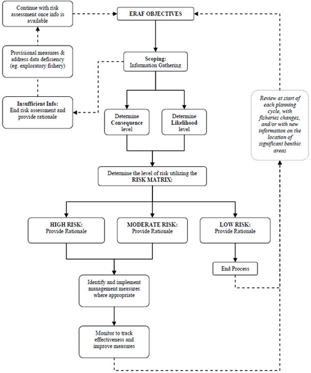
Text Description of Figure 1
This figure is a flowchart of the many different steps in the Ecological Risk Assessment Framework or ERAF process.
The first step shows a rectangular shaped box with the text in it called ‘ERAF Objectives’ that has a solid arrow connected downwards to another box called ‘Scoping: Information Gathering’. From this box, there is an arrow (with a dashed line) that connects to another box to the left side called ‘Insufficient info: End risk assessment and provide rational’, then the line connects to another box called ‘Provisional measures & address data deficiency’ (e.g. exploratory fishery)’ and continues to another box called ‘Continue with Risk assessment once info is available’. This box then connects to the original box called ‘ERAF objectives’ to finish the loop.
From the ‘Scoping: Information Gathering’ box, there is a solid line or pathway connecting two arrows (or two activities) and these boxes are called: ‘Determine the Consequence level’ and ‘Determine the likelihood level’. Both boxes are then connected to another box called: ‘Determine the level of risk utilizing the RISK MATRIX’. This box then connects to three other boxes, called ‘High risk’, ’Moderate risk’ and ‘Low risk: provide rational’. The boxes with High and Moderate risks both connect with an arrow to a box called ‘Identify and implement management measures where appropriate’ and then further to a box called ‘Monitor to track effectiveness and improve measures.’ The box called ‘Low risk: provide rational ‘ connects to box called ‘End process’. This box ‘End process’ terminates the ERAF process. However, there is a long dashed line that connects to the box ‘Monitor to track effectiveness and improve measures’ as well as a long dashed line on the right hand side of the diagram to another box called: ‘Review at start of each planning cycle, with fisheries changes, and/or with new information on the location of significant benthic areas’. The dashed line arrow continues to loop back to the box called ‘ERAF objectives’.
4. Developing Objectives for Risk Assessment
In general, the objective of an ecological risk assessment is to provide managers with an estimated level of risk for serious or irreversible harm to significant benthic areas resulting from fishing activity using a specified gear type.
In order to ensure that the risk assessment provides practical and constructive outcomes, fisheries managers should clearly outline the objectives of the assessment as they relate to specific fisheries, gear types, significant benthic areas, geographical region, etc. Specific objectives will help ensure requests for scientific advice are clear and that fisheries managers have the information needed to inform decision making.
Based on the level of risk, a secondary objective of the process is to provide advice on potential management measures that will mitigate or avoid serious or irreversible harm as required under the Policy.
Example - Ecological Risk Assessment Objectives for offshore shrimp (SFA6):
- Estimate the level of risk to significant cold-water coral and sponge dominated communities presented by the use of otter trawl gear within the offshore shrimp fishery in SFA6.
- Risk levels are defined in consideration of current mitigation measures for benthic impacts employed in the fishery.
- Significant cold-water coral and sponge dominated communities are defined as those areas referred to in Appendix A of the ERAF.
- Based on the level of risk, provide advice on potential mitigation measures available for the fishery.
5. Scoping
To properly formulate the risk scenario it is important to have the appropriate level of information, data and expert opinion that will assist in describing both the significant benthic areas and the fishing activity (based upon the use of a specified gear type) which has the potential to impact them. A key step of the risk assessment process involves the collection and consolidation of information regarding the fishing activity and significant benthic areas to be examined through the risk assessment. While publications and other documents are highly desirable, the collective opinion of experts (including traditional and local ecological knowledge, where applicable) is equally valuable, and as such should be identified at this stage. The objectives of the exercise (Section 4) will help in focusing the scoping exercise in terms of both geographic area and fishing activities in question.
The information, data and expert opinions gathered through the scoping exercise should consider the following key questions:
- Where are the significant benthic areas located (including depths) in the area being examined by the risk assessment (Refer to Appendix A)? Include information on taxa, depth and spatial distribution patterns (e.g. large aggregations, small clusters). Where possible, include additional information (e.g. vulnerability and recoverability of those species which make up the sensitive benthic areas, the general distribution of the species outside of the assessment area) which may prove useful in the development of management options (see Section 7).
- What is the historic fishing footprint of the gear type under consideration in the area being examined by the risk assessment? Include fishing depths and map(s) where possible.
- What is the current fishing footprint of the gear type under consideration in the area being examined by the risk assessment (i.e. current or immediately preceding fishing year)? Include fishing depths and map(s) where possible.
- Are there any plans/proposals for significant changes in the profile of the fishery (e.g. changes in gear types utilized, expansion into new fishing areas) in the current planning cycle? Describe these as they relate to changes in the fishing area/depths and gear modifications.
- What is the anticipated future fishing footprintFootnote 2 of the gear type under consideration in the area being examined by the risk assessment (i.e. anticipated footprint during the planning period)? Include fishing depths and map(s) where possible.
NOTE: This question only needs to be addressed if there are plans within the planning cycle to expand the fishing footprint beyond the current footprint.
As noted in Section 2, information, data and expert opinion pertaining to these key questions should be well documented in advance of moving to the next stage of the process. Depending on the nature and focus of the risk assessment, additional or alternate questions may be necessary.
If there is insufficient data, information and/or expert opinions to answer the questions outlined above (e.g. in frontier areas where information on significant benthic areas may be lacking), then there is a data deficiency and the risk assessment process as outlined in this document cannot be completed. Document the rationale for this conclusion and delineate necessary actions to address these deficiencies (refer to the Policy with regards to processes for frontier areas). Provisional measures (e.g. gear and/area restrictions, additional monitoring requirements) may be required for some fisheries until a complete risk assessment can be conducted. Once adequate data and information has been collected, a risk assessment (Section 6) should be completed. Note that “insufficient” data and/or information is not the same as “uncertainty” in the data and/or information. Insufficient refers to a lack of data and/or information, while uncertainty refers to confidence in the data and/or information and is discussed further in Sections 6.1 and 6.2.
6. Risk Assessment Process
The risk assessment process consists of an evaluation of available data and information on both the fishing activity utilizing the gear type in question and the biological characteristics of the benthic environment in which this fishery is prosecuted. Based on this information, an assessment is conducted to determine the risk of serious or irreversible harm resulting from fishing activity.
The determination of risk levels involves four primary steps:
- Estimation of the consequence of an overlap between the significant benthic area(s) and the fishing activity which utilizes the gear type under consideration
- Estimation of the likelihood of an overlap between the significant benthic area(s) and the fishing activity which utilizes the gear type under consideration
- Scoring of the risk
- Categorization of the risk
Determining a risk level requires defensible estimates of the consequences and likelihood. To be able to defend estimates, clear rationale should be provided on how estimated levels were chosen, so that the exercise can be traced and verified. Clear rationale also provides a basis from which future assessments can be measured. The information, data and expert opinion collected and consolidated through the scoping exercise (Section 5) form the basis for that rationale, with additional information being provided where appropriate and necessary.
6.1. Consequence
Consequence describes the anticipated degree of impact on the significant benthic areas resulting from an overlap between it and the fishing footprint of the gear type. As the benthic areas under examination have all been identified as being relatively fragile and sensitive to physical impacts and slow to recover, the variable in question is the degree to which the gear type will impact the significant benthic area(s), assuming it is deployed in the same area as the significant benthic area(s). Table 1 outlines four levels which describe this consequence, and their corresponding score.
| Level | Descriptor |
|---|---|
| None (1) | Gear is not known to interact with the benthic environment under normal operations. Examples of potential gear types include harpoon and diving. |
| Low (2) | Gear is known to have minimal interaction with the benthic environment as part of normal operations. Examples of potential gear types include pelagic longline and purse seine. |
| Moderate (3) | Gear is known to interact with the benthic environment regularly as part of normal operations. Area of impacts is roughly equal to the size of the gear itself, as the gear is generally fixed in place once it is deployed (i.e. bottom contact fixed gear)Footnote 3. Examples of potential gear types include pots, bottom set gillnets, and bottom set longline. |
| High (4) | Gear is known to interact with the benthic environment regularly as part of normal operations. Area of potential impact is significantly larger than the relative size of the gear, as the gear is moved over the benthic environment as part of normal operations (i.e. bottom contact mobile gear). Examples of potential gear types include bottom trawl and scallop dredge. |
It is important to consider the reliability of the existing data and information when estimating the consequence of interaction. A lack of confidence in the information and data adds an element of uncertainty to estimated levels. The degree and reasons for any such uncertainty should be recorded in the overall documentation of the risk assessment process, and be taken into consideration when determining next steps and developing management options (see Section 7). Uncertainty should not be confused with insufficient data and/or information, which is discussed in Section 5.
6.2. Likelihood
Likelihood describes the probability that the fishing footprint of the gear type will overlap with locations identified as significant benthic areas. Likelihood should consider the current fishing activity, as well as that anticipated in the near future (i.e. that which is anticipated to occur within the planning period subject to the risk assessment). The historical fishing footprint may prove useful in determining the potential extent of interaction for future fishing activities. Table 2 outlines four levels which describe the likelihood of interaction with the significant benthic area(s).
| Level | Descriptor |
|---|---|
| Never (1) | Overlap between fishing footprint and significant benthic areas never occurs; the fishing activity does not occur in or adjacent to locations identified as significant benthic areas. |
| Rarely (2) | Overlap between fishing footprint and significant benthic areas is rare; occurring only in exceptional circumstances. |
| Occasionally (3) | Overlap between fishing footprint and significant benthic area occurs occasionally under normal fishing practices, but not on a regular basis. |
| Regularly (4) | Overlap between fishing footprint and significant benthic areas is expected to occur on a regular basis under normal fishing practices. |
As with consequence, it is important to consider the reliability of the existing data and information when estimating the likelihood of overlap between the fishing activity and the significant benthic areas. A lack of confidence in the information and data adds an element of uncertainty to estimated levels. The degree and reasons for any such uncertainty should be recorded in the overall documentation of the risk assessment process, and be taken into consideration when determining next steps and developing management options (see Section 7). Uncertainty should not be confused with insufficient data and/or information, which is discussed in Section 5.
6.3. Scoring of Risk
In order to determine the risk that a specific fishing activity will cause serious or irreversible harm to significant benthic areas, the levels for the consequence of interaction (none- 1, low - 2, moderate - 3, major - 4) are multiplied by the likelihood of overlap between the fishing footprint and significant benthic areas (never- 1, rarely - 2, occasionally - 3, regularly - 4). Table 3 outlines the resulting Risk Matrix.
| Consequence | Likelihood | |||
|---|---|---|---|---|
| 1 | 2 | 3 | 4 | |
| 1 | 1 | 2 | 3 | 4 |
| 2 | 2 | 4 | 6 | 8 |
| 3 | 3 | 6 | 9 | 12 |
| 4 | 4 | 8 | 12 | 16 |
6.4. Risk Categories
Risk values are separated into three Risk Categories (Table 4), ranging from low to high risk, that provide guidance on directing management actions based on the risk assessment. Risk categories should not be viewed as discrete units resulting in inflexible management options. Rather, they should be viewed as guidelines only, and are not meant to replace common sense in determining appropriate actions. The final decision on next steps and the resulting management options (Section 7) should be informed by the specific circumstances of each scenario, and the risk level may potentially be shifted higher or lower based on the advice and expert opinion of those conducting the risk assessment (with associated rationale documented).
| Risk Level | Descriptor |
|---|---|
| 1 - 6 | Low Risk - The fishing activity presents a negligible risk of serious or irreversible harm to the significant benthic areas. |
| 8-9 | Moderate Risk - The fishing activity presents a moderate risk of serious or irreversible harm to the significant benthic areas. |
| 12-16 | High Risk – The fishing activity presents a high risk of serious or irreversible harm to the significant benthic areas. |
7. Advice on Management Options to Mitigate Risk
Once risk levels have been identified and categorized, DFO-FAM will work with other relevant departmental sectors, fishery participants and co-management bodies under land claims agreements to develop any necessary management options to avoid or mitigate serious or irreversible harm to the significant benthic area(s). Table 5 outlines general guidelines on the development of management options for the three risk categories. Additional case-specific factorsFootnote 4 may also play a role in determining such options. Hence, thorough documentation throughout the risk assessment process is necessary (Section 2.1). IFMPs, and their associated development and approval processes, provide an appropriate tool through which these management options can be developed, communicated and implemented.
It is essential to keep in mind that the risk assessment process as outlined in this document examines only the “ecological” component of risk. Socio-economic factors, Aboriginal rights and other relevant considerations must also be considered in the development of a final management approach.
As noted throughout this document, concerns regarding the uncertainty of information and data used to determine consequences and likelihood may add varying degrees of uncertainty to the overall calculation of risk. This uncertainty should be taken into consideration when developing management options (hence the need for adequate documentation regarding the degree and reasons for the uncertainty). With a greater degree of uncertainty, a greater degree of precaution should be factored into management options.
Management options developed for one type of significant benthic area (e.g. solitary black corals) may not be suitable for another type of significant benthic area (e.g. widely distributed sea pens). Where the gear type being assessed via this framework is operating in a marine area that contains more than one type of significant benthic area, management options should be developed in consideration of each type of significant benthic area, where appropriate.
All management measures implemented should be monitored to determine the effectiveness of the measures in place, as well has to gather additional data and information which may be used to improve on management techniques.
| Risk Level | Management Guidelines |
|---|---|
| Low Risk (Risk Level 1-6) |
No additional management measures required. If future changes to fishing methodology and/or area are considered, potential impacts to benthic ecosystems should be re-evaluated. |
| Moderate Risk (Risk Level 8-9) |
Management measures may be required to mitigate or avoid serious or irreversible harm to significant benthic areas, depending on the specific circumstances of the fishery and the significant benthic areas in question. Examples of potential management options include gear modifications and/or changes to deployment/retrieval practices. |
| High Risk (Risk Level 12-16) |
Management measures are required to mitigate or avoid the risk of serious or irreversible harm to significant benthic areas. Examples of potential management options include closed areas and/or gear modifications (e.g. using lower impact gear types) or restrictions. |
8. Additional Considerations
The risk assessment process as described above outlines a simplified process which examines the risk of a single gear type operating in a marine area known to contain significant benthic areas. However, numerous fisheries using different gear types may often be occurring simultaneously in any such area. As such, the risk presented by examining only one gear type may not provide the best indication of total risk presented by overall fishing activity. As such, it may be desirable from an ecological perspective to examine all gear types being utilized in a given area through a single risk assessment process. From the perspective of operational efficiency, it may also be desirable to examine multiple or all gear types for a single area.
The benefit of examining multiple gear types in a single process is that it allows those tasked with the assessment an opportunity to consider cumulative impacts in developing management options. In this context, cumulative impacts refer to the sum of the benthic impacts resulting from multiple or all fishing activities occurring in a given area. For example, an assessment examining the risk of lobster pots in a given area may indicate a low risk of serious or irreversible harm to significant benthic areas. A separate risk assessment may indicate that the risk posed by bottom-set gillnets in the same area is moderate. Minimal management action may be considered necessary based on the first risk assessment. However, when total risk and management options are considered in the context of the cumulative impacts of both activities, the need for and extent of management actions may be expanded based upon the knowledge and experience of those experts involved in the overall risk assessment.
The risk assessment process as discussed in this document considers only the direct impacts of fishing gear on sensitive benthic areas (i.e. impacts resulting from contact between the gear and the benthic feature). However, indirect fishing impacts may also be a concern, particularly as it relates to smothering due to sedimentation resulting from fishing activity. The extent and assessment of this threat is poorly understood, and the ERAF makes no attempt to address this potential issue. However, where the effects of sedimentation on significant benthic areas is known, additional management actions may be required outside of that outlined in this document.
Management decisions resulting from the application of the ERAF will be subject to fisheries legislation in general. Additionally, they will take into account relevant land claims agreements, the duty to consult where decisions may adversely affect established or potential Aboriginal or treaty rights, the constitutional protection provided to Aboriginal and treaty rights by Section 35 of the Constitution Act (1982), other departmental policies and other relevant considerations.
9. Timelines
The implementation of the Policy through the ERAF will take a phased-in approach for Canadian fisheries, depending on regional priorities. Once the ERAF has been applied to a specific fishery (or geographic areas), it is recommended that the objectives and results of the ecological risk assessment be reviewed at the start of all subsequent planning cycles for the fishery (or geographic area) in question. Changes to the fishery or improved knowledge of the significant benthic areas may warrant the completion of a revised risk assessment. The results of this planning cycle review (and the results of any revised risk assessment process, where applicable) should be documented and incorporated into associated fisheries management documents (e.g. IFMPs). In addition, it is recommended that the results of all risk analyses be reviewed collectively on a regular basis to ensure that this framework is being applied in a consistent manner.
10. References
DFO. 2010a. Potential impacts of fishing gears (excluding mobile bottom-contacting gears) on marine habitats and communities. DFO Can. Sci. Advis. Sec. Sci. Advis. Rep. 2010/003.
DFO. 2010b. Occurrence, susceptibility to fishing and ecological function of corals, sponges and hydrothermal vents in Canadian waters. DFO Can. Sci. Advis. Sec. Sci. Rep. 2010/041
DFO. 2006. Impacts of Trawl Gears and Scallop Dredges on Benthic Habitats, Populations and Communities. DFO Can. Sci. Advis. Sec. Sci. Advis. Rep. 2006/025.
W. J. Fletcher. 2007. A Guide to Implementing an Ecosystem Approach to Fisheries management (EAFM) within the Western and Central Pacific Region. Forum Fisheries Agency, Honiara, Solomon Islands.
A. J. Hobday, A. Smith, H. Webb, R. Daley, S. Wayte, C. Bulman, J. Downdney, A. Williams, M. Sporcic, J. Dambacher, M. Fuller, T. Walker. 2007. Ecological Risk Assessment for the Effects of Fishing: Methodology. Report R04/1072 for the Australian Fisheries Management Authority, Canberra, Australia.
11. Definitions
Consequence: The anticipated degree of impact on the significant benthic areas resulting from an overlap with fishing activity.
Fishing Footprint: The spatial distribution of fishing effort within a set time period.
Frontier Area: A frontier area is an ecosystem area in deep water (deeper than 2000m) areas or areas in the arctic where there is no history of fishing and little if any information is available concerning the benthic habitat features and the impacts of fishing on these features.
Likelihood: The probability that the fishing activity will overlap with areas identified as significant benthic areas.
Precautionary Approach (PA): If there is both high scientific uncertainty and a risk of serious or irreversible harm, a lack of adequate scientific information will not be used as a reason for failing to take, or for postponing, cost effective measures for the conservation or protection of fish or fish habitat that are considered proportional to the severity of the risk.
Sensitive Benthic Areas: Sensitive benthic areas are areas that are vulnerable to a proposed or ongoing fishing activity. Vulnerability will be determined based on the level of harm that the fishing activity may have on the benthic area by degrading ecosystem functions or impairing productivity.
Serious or Irreversible Harm: Impacts that compromise ecosystems integrity (i.e. ecosystem structure or function) in a manner that: (i) impairs the ability of affected populations to replace themselves; (ii) degrades the long-term natural productivity of habitats; or (iii) causes, on more than a temporary basis, significant loss of species richness, habitat or community types.
Significant Benthic Areas: Significant areas of coral-water colds and sponge dominated communities. Significance is determined through guidance provided by DFO-lead processes based on current knowledge of such species, communities and ecosystems. Such guidance may be modified over time, as knowledge of such areas is refined through additional studies. It is anticipated that significant benthic areas will be identified prior to the completion of an ecological risk assessment process. Further details are provided in Appendix A.
APPENDIX A:
The process outlined in the ecological risk assessment framework is to be applied only to those “significant” areas of coldwater corals and sponge dominated communities, otherwise referred to as significant benthic areas. However, defining what areas constitute significant benthic areas can be challenging, and area may vary depending on the environment being examined and the perspective of those conducting the risk assessment. As such, guidance is required.
In March 2010, Fisheries and Oceans Canada held a national science advisory process to peer-review available information, and provide science advice, concerning the occurrence, sensitivity to fishing, and ecological function of corals and sponges in the Canadian Exclusive Economic Zone (EEZ). The results of this peer-review process were published in the Canadian Science Advisory Secretariat (CSAS) Science Advisory Report (SAR) 2010/041 (DFO, 2010b), and provide useful information which can be used as a nationally consistent approach to defining significant benthic areas.
The SAR reviews a suite of ecological indicators, including uniqueness, rarity, species density, species richness, species distribution, and species diversity. The strengths and weaknesses of these indicators are discussed. The report also outlined three methodologies (i.e. cumulative distribution, area of aggregation, and species distribution models) that are considered appropriate predictors of several ecological indicators.
The information provided in the SAR should prove invaluable to those tasked with the implementation of the ecological risk assessment framework. Mapping work based on the cumulative distribution and area of aggregation models are particularly useful in identifying significant benthic areas for those taxa which are aggregating in nature. Other information presented in the report, including locations of non-aggregating rare species such as black corals, should also prove very useful in identifying significant benthic areas.
It is anticipated that the results of SAR 2010/041 will be utilized to support regional and zonal initiatives to define significant benthic areas and implement the ERAF for coldwater corals and sponge dominated communities. However, it is also recognized that, in some cases, it may be necessary to undertake further work to expand upon the advice provided by the SAR in order to identify the significant benthic areas of a given marine area. For example, this may be necessary for unique and/or rare species that are non-aggregating in nature, and thus may not have been identified in the report. Furthermore, the identification of significant benthic areas may be further refined by considering the presence of such features relative to the location of other significant benthic areas or other structural features.
Any efforts to expand upon or refine the information presented in the SAR should be conducted in a transparent and well documented process. Where possible, formal peer review processes should be utilized to ensure that the results are consistent with the overall nature of the advice presented in the original report.
- Date modified: