
Strategic Environmental Assessment
Rustico Harbour / Bay
Prepared Department of Fisheries and Oceans & Parks Canada
Final Report
Project No: 042641
May 2007
Table of Contents
Executive Summary
- Background
- Mandate of the Strategic Environmental Assessment (SEA)
- Stakeholder Consultations
- Options Defined
- Analysis and Results
- Legislative Requirements
- Associated Cumulative Effects
- Strategic Benefit - Cost Analysis
- Summary Observations
Tables
- Table A: Rationale for Evolution of Alternatives Examined in the SEA
- Table B: Summary of SBCA Results
- Table C: Summary of SEA Findings and Implementation Implications
Figures
Executive Summary
Background
The study area, referred to as Rustico Harbour/Bay, is located in Queens County on the North Shore of Prince Edward Island (PEI). Covering approximately 28,000 hectares, it is defined by the Hunter and Wheatley river watersheds and includes the North Rustico harbour channel and a portion of the PEI National Park on Robinsons Island. Robinsons Island, a classical barrier island, is the main feature of the coastal environment, which is also characterized by sand beaches, dunes, salt marshes and the nearshore zone of the Gulf of St. Lawrence. Farming, fishing, aquaculture and tourism are the economic drivers of the local economy.
The coastal processes, influenced by the natural processes of tides, currents, waves and sediment transport, are complex and continually evolving at Rustico Harbour/Bay. The area is also sensitive both to the effects of sea-level rise and to the impact of storms which directly affect the stability of the shoreline. In addition, over the years, significant landscape changes have occurred as a consequence of human intervention. The construction of coastal infrastructure in the area dates back to 1881 and culminated in 1956 when the Little Harbour Inlet between Robinsons Island and the mainland of PEI was closed with a causeway, referred to in this report as the Little Harbour Causeway. As a result, the tidal flow was redirected through the North Rustico harbour channel, and for the next 20 to 30 years substantial coastal changes took place. New tidal channels formed, and some 2 to 3 km of Robinsons Island retreated landward to form Dune Bar. By the early 1990s the North Rustico harbour channel and the “new channel” between Robinsons Island and Dune Bar had evolved into two separate systems, both draining into the Gulf of St. Lawrence. Historically, intervention had also included the intermittent dredging of the North Rustico harbour entrance channel. Since 1989, however, the North Rustico harbour channel has been permitted to seek its own configuration in an effort to scour a harbour entrance that would require little, if any, maintenance dredging.
Over the course of many years, residents of the Rustico Harbour/Bay area have expressed concern about a number of issues including navigational access and safety into and out of North Rustico harbour; water quality in the Wheatley and Hunter river estuaries; erosion of the western end of Robinsons Island; and shoreline instability. In time, concerned residents became organized and formed a number of non-government organizations, some of which advocated further physical intervention. Most notably, in 1995, the North Queen’s Wildlife Federation (NQWF) presented a brief to the Government of Canada with a three phase proposal intended to restore the landscape back to its original configuration before the construction of the Little Harbour Causeway.
In response, the Minister of Canadian Heritage requested the formation of the Rustico Island Causeway Working Group, and in 1998, the group recommended a modified version of the previous NQWF proposal including:
- Phase 1 – improvements to the North Rustico harbour channel including the construction of an eastern breakwater and subsequent monitoring of the consequences;
- Phase 2 – dredging of Dune Bar and the restoration of the western end of Robinsons Island; and
- Phase 3 – removal of the Little Harbour Causeway.
The Minister of Canadian Heritage referred the modified three phase proposal to the Minister of Fisheries and Oceans - (DFO), the department responsible for fishing harbour infrastructure under its Small Craft Harbours’ (SCH) program. At that time, DFO determined that the cost of an eastern breakwater alone, as the first phase of the proposal, would be several million dollars. This estimate was based on previous studies including the modeling of the North Rustico entrance channel. Given the high cost and the lack of evidence in support of enhanced navigation, DFO decided not to proceed.
In 2002, representatives of the community, Parks Canada and DFO were called to make presentations to the Standing Committee on Fisheries and Oceans (SCOFO) on the situation in the Rustico Harbour/Bay area. SCOFO subsequently made recommendations in support of the modified three phase proposal, which included the undertaking of an environmental assessment (EA) of the project followed by the implementation of Phase 1. Upon consideration of SCOFO’s recommendations, the Government of Canada decided that further study was needed to examine the full range of social, economic and environmental impacts of carrying out any action in the Rustico Harbour/Bay area. Specifically, the Government of Canada recommended that a Strategic Environmental Assessment (SEA) was required.
Mandate of the Strategic Environmental Assessment (SEA)
In 2004, CBCL Limited was contracted by DFO and Parks Canada through Public Works and Government Services Canada (PWGSC) to prepare this SEA in accordance with the Government’s commitment to the 2004, Cabinet Directive on the Environmental Assessment of Policy, Plans and Proposals. While DFO was identified as the Technical Authority responsible for all matters relating to the execution of the SEA, support and guidance through the execution of the work was provided by representatives from both DFO and Parks Canada.
The SEA process is strongly linked to government goals of sustainable development and addressing the cumulative, synergistic and long-term effects of proposed actions. Its purpose is to clarify issues, to integrate the views of all stakeholders and to provide decision-makers with a balanced evaluation of possible courses of action. The emphasis has been to understand the problems, to strategically evaluate alternatives that have been put forth and to identify those actions that might best address identified issues with minimal risk to the environment in a cost effective manner. The approach has involved:
- review of past studies undertaken as an integral part of the events that lead to the recommendations of the Rustico Island Causeway Working Group and, in addition, the compilation and review of subsequent work pertinent to the issues identified;
- design and execution of a series of focus group meetings with stakeholders and parallel consultations with representatives of federal, provincial and municipal government representatives;
- review and redefinition of the alternatives in light of the outcome of the focus group meetings and consultations;
- definition and costing of each alternative;
- review of the legislative procedures that would be triggered by the execution of each alternative;
- strategic environmental evaluation of the defined alternatives;
- evaluation of potential cumulative effects; and
- execution of a strategic benefit - cost analysis of the alternatives.
With one exceptionFootnote 1, no fieldwork was conducted as part of the SEA. The analysis conducted under this SEA was based on the considerable work done previously, much of it in relation to issues spawned by construction of the Little Harbour Causeway in 1956. A series of reports prepared by W.F. Baird and Associates (1990, 1996, 1999) describing modeling undertaken of the Rustico Inlet, and other documents describing water quality and sedimentation in Rustico Bay (Brylinsky, M., 1997, and Anderson, C., 1998) along with information provided by federal and provincial agencies were reviewed and provided essential input to the evaluation.
Stakeholder Consultations
An essential dimension of the SEA was to consult with a wide range of interested stakeholders including area residents, Aboriginal peoples and representatives of all levels of government. The goal was to provide stakeholders with the consultant’s understanding of the history of the events that led to the present circumstances and to derive alternatives on how to move forward. This was achieved through the preparation and distribution of the Strategic Environmental Assessment for Rustico Harbour/Bay Workbook: Stakeholder Focus Group Consultation (the Workbook), followed up by a series of focus group meetings. Stakeholders were requested to discuss the Workbook material in an informal manner and encouraged to offer additional information, correct misunderstood facts and to express their opinions on what they understood to be reasonable steps towards addressing the issues being experienced in the study area.
Options Defined
The original six alternatives, derived from those originally proposed by the North Queen’s Wildlife Federation (NWQF), were presented at the focus group meetings and at meetings with federal and provincial departments.
The two primary concerns resulting from the consultations were:
- navigational access and safety into and out of North Rustico harbour; and
- water quality in the Wheatley and Hunter river estuaries.
Dredging has not been carried out at North Rustico since the channel was allowed to seek its own alignment in 1989, which suggests that a certain level of stability has been attained with respect to channel orientation and water depths. Many mariners who use the channel on a regular basis, however, were adamant that the existing channel does not facilitate the safe passage of boats of 45 ft (13.7 m) with a draft of 1.5 m due to the irregular shape and shifting position of the channel. A hydrographic survey undertaken in the summer of 2005 did identify channel constrictions. The minimum depth of the channel inside the harbour is - 1.5 m chart datum (CD), which occurs over a shoal midway between the marina and the wharf. An offshore shoal, beyond the breakwater, has a minimum depth of - 1.0 m CD within the area surveyed and also represents a navigational constraint. Certainly, the channel as presently configured cannot safely accommodate vessels larger than those that currently use it.
Many individuals also referenced broader issues including community planning and future economic prospects for the area; some related these questions to ecosystem health. For example, the pungent odour associated with the eutrophication in the estuaries was seen as a factor that inhibited investment, an important linkage. The community of North Rustico is an important centre in the economic and community life of the North Shore of PEI, and it was repeatedly emphasized that its future prosperity was linked to safe and reliable harbour access and to addressing problems, such as eutrophication, that deterred visitors from stopping in the area. Certainly the community’s concern has much to do with the identification of North Rustico as a key fishing, tourist and recreational harbour and the investment that has already been made to upgrade infrastructure in the harbour, including the creation of a marina. Other concerns that were articulated were agricultural practices, the potential disturbance of potential archaeological sites as well as sedimentation and infilling.
In order to address both the primary and other concerns expressed during the consultations, the original alternatives were redefined and subsequently four alternatives were assessed. The redefined alternatives are:
- Alternative I: Status Quo with Mitigation;
- Alternative II: Enhanced Navigation;
- Alternative III: Modified Three Phase Proposal; and
- Alternative IV: Enhanced Watershed Stewardship Program.
Table A provides a summarized rationale for how the original alternatives were redefined into the four that were carried through the SEA process. The revised alternatives address the primary concerns expressed by the stakeholders and included a stronger emphasis on navigational access and safety into and out of North Rustico harbour and the introduction of a new alternative, Enhanced Watershed Stewardship Program. Figure 1 provides a reference to the study area and the locations of most relevance to the alternatives assessed.
| Original Alternatives | Reasons for Retaining, Modifying or Dismissing Alternative | Alternatives Assessed |
|---|---|---|
| A: Status Quo | Retained but modified: Developed as the base case to address navigational access and safety into and out of North Rustico harbour. | I: Status Quo with Mitigation: including the continued execution of DFO and Parks Canada mandates |
| B: Removal of the Little Harbour Causeway | Dismissed: The removal of the causeway in itself would not address the primary concerns expressed by the stakeholders. It remains a phase of Alternative III. | |
| C: Enlargement of the Hunter and Wheatley river bridge channels | Dismissed: Proposed works in isolation would not address the issue of eutrophication. A revised alternative was proposed that would examine infrastructure, including the need to widen bridge channels, as part of a more comprehensive watershed stewardship approach. | IV: Enhanced Watershed Stewardship Program, i.e., a comprehensive approach to address water quality issues throughout the watersheds of the study area |
| D: NQWF Three Phase Proposal | Dismissed: Proposed sequence was dismissed in favour of Alternative III, the recommendation of the Rustico Island Causeway Working Group and the Science Advisory Group. | |
| E: Improvements to the North Rustico navigation channel | Modified to present a more effective solution to create a channel for larger, deeper draft vessels. | II: Enhanced Navigation at North Rustico |
| F: Modified NQWF Three Phase Proposal | Retained to reflect the modified concept recommended by the Rustico Island Causeway Working Group. | III: Modified Three Phase Proposal |
Analysis and Results
By conducting a SEA and involving stakeholders in the process, the Government of Canada’s goal is to gain a better understanding of the long-term costs, benefits and uncertainties of the various proposed options in order to determine the most appropriate way to address social, economic and environmental concerns.
The analysis undertaken involved the identification of biophysical and socio-economic attributes, pathway analysis requiring applicable attributes to be clearly linked to the operation and construction aspects of each alternative and professional judgment and experience. The following paragraphs summarize the principal findings of the evaluation.
Alternative I, Status Quo with Mitigation, proposes to dredge the channel to a depth of - 1.5 m CD and to a width of 20 m for navigational access for a typical 45 ft (13.7 m) long and 15 ft (4.5 m) wide fishing vessel in PEI. This alternative represents a conservative and risk-averse approach that is unlikely to exacerbate the longshore transport of sediment, or other processes, that could instigate shoreline instability. The implementation of this alternative will not impact adversely on identified attributes such as wildlife, Species of Concern, or their associated habitat or on the PEI National Park (the National Park). This alternative also respects Aboriginal interests to protect archaeological integrity and would improve existing navigational conditions of the entrance channel. While it is intended to improve navigational access and safety for vessels up to 45 ft (13.7 m), it will not increase the navigational capacity of the North Rustico channel, nor will it address water quality in the Wheatley and Hunter river estuaries.
Alternative II, Enhanced Navigation, would involve the following physical works and activities: the design and construction of twin training walls and the execution of a regular dredging program over the offshore shoal to create a navigational channel that could allow navigational access for vessels up to 65 ft (19.8 m). The maintenance of such a channel would be favourably received by the community as it would support their objectives for economic development based on accessibility for larger vessels. On the other hand, there are many unknowns associated with the execution of this alternative. The regular dredging of the offshore shoal might be a catalyst for a period of substantial coastal change that, in turn, could have negative consequences for nearshore coastal habitats and the National Park. This alternative would not address the water quality issues in the Wheatley and Hunter river estuaries.
Alternative III, the Modified Three Phase Proposal, would involve the sequential development of an eastern breakwater, the dredging of Dune Bar and its reconnection to Robinsons Island, and the removal of the Little Harbour Causeway. The primary benefit anticipated from the construction of the eastern breakwater would be that it would provide an improved level of stability to the channel alignment, thus improving navigational access for vessels up to 45 ft (13.7 m). It would not facilitate safe passage of vessels of deeper draft, nor would it permanently address the issues associated with the offshore shoal. In the absence of modeling of a defined engineered design, there remain unknowns associated as to how the eastern breakwater might influence the nearshore dynamic of deposition and erosion, i.e., there is an element of risk. The subsequent phases of Alternative III involve major marine construction, the full implications of which are not known, but they have the potential to cause major impacts on most of the identified biophysical and socio-economic attributes, i.e., it is an alternative that poses many environmental risks. This alternative would not bring about any improvement in water quality in the Wheatley and Hunter river estuaries.
Figure 1. Geographical Context of Proposed Alternatives for Rustico Harbour/Bay Sea
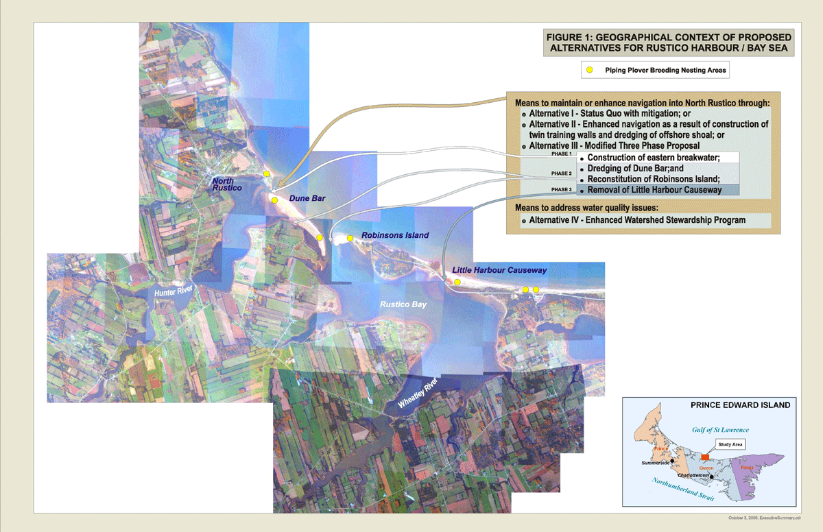
This figure includes a composite map of the area studied for the strategic review. It indicates the locations that would be affected, depending on which of the four proposed alternatives that were reviewed for the study, were implemented. It also indicates the areas that are breeding nesting areas for the piping plover, a species of bird that is listed as endangered under Schedule 1 of the Species at Risk Act.
Alternative IV, the Enhanced Watershed Stewardship Program, proposes the development and execution of an enhanced watershed stewardship program, which over time, would result in substantial ecological benefits throughout the watersheds of the study area. The implementation of such a program would have a positive impact on water quality in the Wheatley and Hunter river estuaries. The approach is risk-averse, concurs with Aboriginal interests to maintain archaeological integrity and does not adversely affect Species of Concern or the habitats on which they depend. While it does not address navigational access and safety, it is the only alternative under consideration that would address the water quality issues that are important to stakeholders.
Legislative Requirements
The implementation of any of the alternatives would involve, to varying degrees, input from a number of federal and provincial government departments, including the execution of their regulatory mandates. Any execution of proposed projects would, because of the approvals, authorizations and permits possibly required pursuant to the Navigable Waters Protection Act, the Fisheries Act and the Canadian Environmental Protection Act as well as the stipulations of the Canada National Parks Act, be subject to the federal, and possibly provincial, EA processes. In light of the protection afforded certain species and their critical habitats pursuant to the Species at Risk Act, the regulatory process could be prohibiting. Depending on the magnitude, complexity, and the significance of any adverse effects, the EAs associated with the alternatives could be rigorous, time consuming and costly.
The alternatives proposed, for example, would be subject to the considerations of the Canadian Environmental Assessment Act (CEAA). The determination of the scope of a project under CEAA is an important factor and must be made on a case-by-case basis. Every component in connection with a project development should be considered as part of the overall project, though components which remain hypothetical do not have to be taken into account. Alternatives I, II, and III consist of a number of components (e.g., initial dredging, construction of marine works and follow-up dredging activities) which could be scoped collectively as one project, regardless of intermittent construction operations and in the case of Alternative III, the uncertainty involved in moving from one phase to the next. The implementation of Alternative IV may or may not trigger the federal EA process depending on the nature of the individual project components that may be proposed.
Associated Cumulative Effects
While it is important to consider the consequences of the specific alternatives, it is also important to take into account other concurrent changes that could be taking place in the study area that may have an additive or synergetic effect, i.e., cumulative effect. This SEA provides an overview of potential cumulative effects and interactions, but recognizes that an evaluation of specific cumulative effects related to the alternatives would need to be conducted as part of a project specific EA. A summary evaluation of the potential interaction between various activities within the study area and the alternatives was conducted.
The most likely cumulative effects are those associated with alternatives that have the potential to adversely affect water quality, even on a short-term basis, by increasing the levels of suspended sediments within the estuaries. The potential for cumulative effects would be directly related to the capacity of the estuaries to assimilate any increased sediment loads, i.e., if the estuary is near its assimilative capacity threshold, any increased sedimentation associated with the alternatives could interact with existing activities in the study area to have a synergetic effect. The synergetic effect would be proportional to the magnitude of the dredging and marine construction components undertaken, e.g., those associated with Alternatives I, II and III. The issue of sedimentation is also relevant to Alternative IV, Enhanced Watershed Stewardship Program, but not in the context of adverse cumulative effects. Rather it the only alternative that is designed to mitigate existing levels of suspended sediments in the watersheds, i.e., the assimilative capacity of the river and estuarine systems should be increased over time. This would result in a potential reduction of adverse cumulative effects.
Strategic Benefit - Cost Analysis
Although no detailed engineering has been done with respect to any of the proposed marine structures associated with the alternatives under consideration, conservative assumptions have been made and cost estimates prepared to facilitate the execution of a strategic benefit - cost analysis (SBCA). This analysis centres on the proposition that all alternatives will, at a minimum, protect the current economic value of the study area, including North Rustico harbour. The differences among alternatives arise both from their relative costs and from their relative effects on other economic values. Table B summarizes the results of the analysis undertaken.
| Alternative | Financial Costs | Transition Costs | Economic Effects |
|---|---|---|---|
| I: Status Quo with Mitigation (Base Case) | Capital cost – $0 O&M costs – $240,000 / annum |
No transition costs (by definition). | Continuation of current levels of economic activity and maintenance of the potential for development. |
| II: Enhanced Navigation | Capital cost – $15.6 M O&M costs – $690,000 / annum |
Minor direct transition costs (with the potential for risky investments to be made before the new physical “equilibrium” is reached). | Maintenance (perhaps enhancement) of the current levels of economic activity and potential for development. Recreation benefits from increased vessel access. |
| III: Modified Three Phase Proposal | Capital cost – $38.1 M O&M costs – $260,000 / annum for Phase 1 (and substantially more for Phases 2 and 3) |
Likely 20 to 30 year transition costs to the aquaculture sector, potentially to property owners, to recreational users and to wildlife resulting from habitat changes. | Maintenance (perhaps enhancement) of the current levels of economic activity and potential for development. Likely major (and unpredictable) negative environmental (wildlife habitat, etc.) and potentially recreational use impacts. |
| IV: Enhanced Watershed Stewardship Program | Program cost – $1.5 M | The potential to take some agricultural land out of production. Additional cost of new agricultural management practices. | No change in navigational access and safety into and out of North Rustico harbour. More sustainable agricultural practices, improved habitat for birds, wildflowers and fish, improved water quality, and enhanced recreational opportunities. |
Notes: Transition Costs – are the economic costs due to the transition period between the beginning of an intervention until the new equilibrium is reached. For example, if dredging activities disturbed fishing or boating activity for some period after completion, there would be economic transition costs arising from the period of disturbance. O&M Costs – are the costs of operating and maintaining a new structure or alternative.
Summary Observations
The SEA was undertaken to evaluate the likely consequences of several alternatives, any one of which might ameliorate to some extent concerns that have arisen after construction of the Little Harbour Causeway in 1956. The following factors are of paramount importance to the decision-making process:
- the susceptibility of the coastal area to rapid physical change, due to naturally occurring events such as storms, as well as human interventions, such as the construction of new coastal structures;
- the importance of climate change and sea-level rise in the study area and on any works that may be constructed has been and will continue to be substantial;
- the vulnerability of the surface and ground water systems to inappropriate human practices; and
- the costs associated with the alternatives under consideration as measured against operational benefits and, in some instances, the high environmental risks involved.
The biophysical and socio-economic evaluations undertaken show that the more serious consequences of implementing one or other of the alternatives are:
- instigation of coastal instability through the implementation of major physical works and activities, e.g., those associated with Alternatives II and III, which could lead to sudden physical change in an already dynamic coastal regime; and
- impacts to Species of Concern, or their critical habitat, as a result of dredging Dune Bar, the restoration of Robinsons Island and/or the removal of the Little Harbour Causeway.
In general, Alternatives II and III, which involve the construction of major marine works and dredging activities, have associated with their implementation major uncertainties, particularly unpredictable coastal change. Alternatives I and IV are less intrusive physically and are more likely to address incrementally some of the issues that have been raised. There is no single alternative that will address the primary issues that have been identified, namely improve navigational access and safety into and out of North Rustico harbour and the water quality in the Wheatley and Hunter estuaries.
Based on the evaluation undertaken, the greatest benefits that could emanate from the alternatives considered and with least risk to the environment, would be support for better management of the land resource, i.e., Alternative IV, and the Status Quo with Mitigation with respect to navigational access and safety into and out of North Rustico harbour, i.e., Alternative I. These alternatives could be implemented collectively or independently and would create benefits at little or no risk. Alternative II, Enhanced Navigation, improves the channel, but at a considerable cost and at a substantial risk to the environment. The adoption of Alternative III, even if implemented in phases, poses many risks and high costs, but few tangible benefits.
Over the longer term, i.e., the next 40 to 50 years, the communities in the study area and the various responsible federal and provincial government agencies have challenges to meet and address. The issues associated with the longshore sediment transport and erosion, for example, are an inherent dimension of the physical environment on the North Shore of PEI. Coastal change will continue to be negatively impacted by large storm events and effects will be further exacerbated by climate change and sea-level rise. On the one hand, such change can be large in scale, rapid in occurrence and very damaging in its consequences. In contrast, the incremental changes that pose concern in the watersheds are smaller in scale and the consequences accumulate over time.
Table C includes a summary of the major implications of the biophysical and socio-economic attributes, costs, regulatory requirements, environmental risk and the potential effects of the environment for each alternative.
| Alternative I: Status Quo with Mitigation | Alternative II: Enhanced Navigation | Alternative III | Alternative IV: Enhanced Watershed Stweardship Program | ||
|---|---|---|---|---|---|
| Phase I: Eastern Breakwater | Phases 2) & 3)Footnote 2 | ||||
| Attributes | Major Implications | ||||
| Biophysical Attributes | No major impacts | Potential long-term major negative impacts on Longshore Sediment Transport & Shoreline Stability, Coastal & Estuarine Sediments, Coastal & Estuarine Habitats, Benthic Communities, Fish & Shellfish and Species of Concern | Potential negative short and long-term impacts on Species of Concern | Potential short and long-term major negative impacts on Longshore Sediment Transport & Shoreline Stability, Coastal & Estuarine Sediments, Coastal & Estuarine Habitats, Benthic Communities, and Species of Concern; potential major short-term impacts on Fish & Shellfish | Major positive long-term impact on Water Quality |
| Socio-economic Attributes | No major impacts | Potential long-term major positive impacts on Commercial Fishery, Navigational Access & Safety and Economic Aspirations; potential long-term major impacts on Aboriginal Interests and Special Places | No major impacts | Potential short and long-term major negative impacts on Aboriginal Interests, Tourism & Recreation, Special Places, and Landscape Aesthetics; potential major short-term negative impact on Aquaculture; potential major long-term impact on Navigational Access and Safety | Major positive long-term impact on Landscape and Aesthetics |
| Other Considerations | Implications | ||||
| Capital Costs | $0,0 M Nil |
$15,6 M High |
$6,3 M Moderate |
$31,8 M High |
$780 KFootnote 4 Low |
| Annual Maintenance and Post Construction Monitoring Costs | $240 K / annum Moderate |
$690 K / annum High |
$260 K / annum Low |
Note Footnote 3 | $170 K / annum |
| Regulatory Requirements | Low | High – Potential for regulatory prohibition | Moderate | High – Potential for regulatory prohibition | Low |
| Environmental Risk | Low | High | Moderate | High | Low |
| Potential Effects of Environment | Moderate | High | High | High | Low |
| Addresses Key Issues | |||||
| Navigational Access and Safety into and out of North Rustico harbour | YES - Improves navigational access and safety for 45 ft (13.7 m) vessels | YES - Improves navigational access and safety for vessels up to 65 ft (19.8 m) | YES - Improves navigational access and safety for 45 ft (13.7 m) vessels | NO – Potential major negative impact | NO |
| Improves Water Quality in the Wheatley and Hunter River estuaries | NO | NO | NO | NO | YES – Positive long-term impact |
- Date modified: