
Commercial Fishery – Arctic Region – Freshwater
Stock status and research documents | Maps | Consultations | Contacts
Inconnu (Stenodus leucichthys) in Great Slave Lake are caught incidental to the whitefish (Coregonus clupeaformis) and lake trout (Salvelinus namaycush) commercial fishery. The Buffalo River stock of Inconnu is currently listed as critical within the Department of Fisheries (DFO) precautionary approach framework, and many other stocks have been extirpated (i.e., they are no longer found in the geographic area). A variation order closing a portion of the Area 1E management zone in the late summer promotes inconnu stock recovery.
Notices, variations and decisions
- Arctic Region Variation Order 2024-012
- Arctic Region Variation Order 2024-011
- Arctic Region Variation Order 2024-006
Stock status and research documents
- Assessment of the potential to re-open Great Slave Lake Closure Zones A and B (dfo-mpo.gc.ca)
- Development of a lake-wide multi-species fishery-independent survey for Great Slave Lake. - Catalogue - Canada.ca
- Assessment of lake whitefish status in Great Slave Lake, Northwest Territories, Canada, 1972-2004 / Canadian Science Advisory Secretariat - Catalogue - Canada.ca
- Assessment of the potential to re-open Great Slave Lake closure zones A and B / Contributors: Randy Brown, Theresa Carmichael, Kimberly Howland, Deanna Leonard, George Low, Kathleen Martin, Ross Tallman, Melanie Toyne, Xinhau Zhu ; Canadian Science Advisory Secretariat - Catalogue - Canada.ca
- Assessment of Buffalo River inconnu (Stenodus leucichthys) Great Slave Lake, Northwest Territories, 1945-2009 - Catalogue - Canada.ca
- Proceedings of the Regional Advisory Process on the Buffalo River inconnu (Stenodus leucichthys) population, Great Slave Lake, Northwest Territories, March 30-31, 2010, Yellowknife, NT = Compte rendu du processus de consultation scientifique régional sur la population d'innconnu (Stenodus leucichthys) de la rivière Buffalo, Grand Lac des Esclaves, Territoires du Nord-Ouest, 30-31 mars 2010, Yellowknife, TNO / Michael Papst Meeting chairperson/Président de réunion - Catalogue - Canada.ca
Maps
Map 1: Great Slave Lake commercial fishing management areas
Effective: Nov. 1, 2023 to Oct. 31, 2024
Closed areas subject to change
Questions:
- DFO Hay River: 867-875-5300
- DFO Yellowknife: 867-669-4900
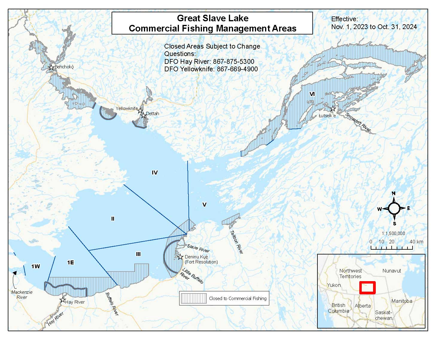
Figure 1. Great Slave Lake commercial fishing management areas.
Long description
Figure 1 is a map of Great Slave Lake including portions of the Mackenzie River near the lake as well smaller waterbodies surrounding the lake. The map is subdued/light in color with Great Slave Lake and surrounding waterbodies indicated by light blue and major highways by thin orange lines. Hatched areas indicate portions of the lake and adjacent waterbodies closed to commercial fishing, thick blue lines indicate the offshore limits of domestic fishing zones, and thin blue lines indicate the management areas of Great Slave Lake. The communities of Yellowknife, Hay River and Fort Resolution (Denı́nu Kų́ę́) are labelled with text and indicated by white stars. Major rivers such as Snowdrift River, Taltson River, Slave River, Little Buffalo River, Hay River and Mackenzie River are labelled with text. The management zones are labelled with text near the central portion of each zone and include the text 1W and 1E as well as Roman numerals 2, 3, 4, 5 and 6, the zones are labelled progressing west to east from 1W/1E to zone 6.
An inset in the lower right corner shows a large-area view of western Canada with provincial and territorial labels overlaid by a red box that indicates the portion of covered by the map of Great Slave Lake commercial fishing management areas.
Another inset contains a legend that shows the hatch style for the areas that are closed to commercial fishing.
Several text labels on the map of Great Slave Lake are present including:
- a title block at the top centre of the map with the text Great Slave Lake Commercial Fishing Management Areas
- text in the upper right corner of the map state the map is effective from Nov. 1, 2023 to Oct. 31, 2024; the map is reviewed and updated for the start of every fishing season before November 1st.
- text in the left centre of the map reads see over for detailed map of Area 1 (East) and Area 3
- text immediately below the title block states that the closed areas are subject to change, for questions call the DFO Hay River office at 867 875-5300 or the DFO Yellowknife office at 867 669-4900
In the lower right corner of the map and above the inset is a compass rose, a map scale of 1:1,500,000 and a scale bar in kilometres.
Map 2: Southwest Basin
Effective: Nov. 1, 2023 to Oct. 31, 2024
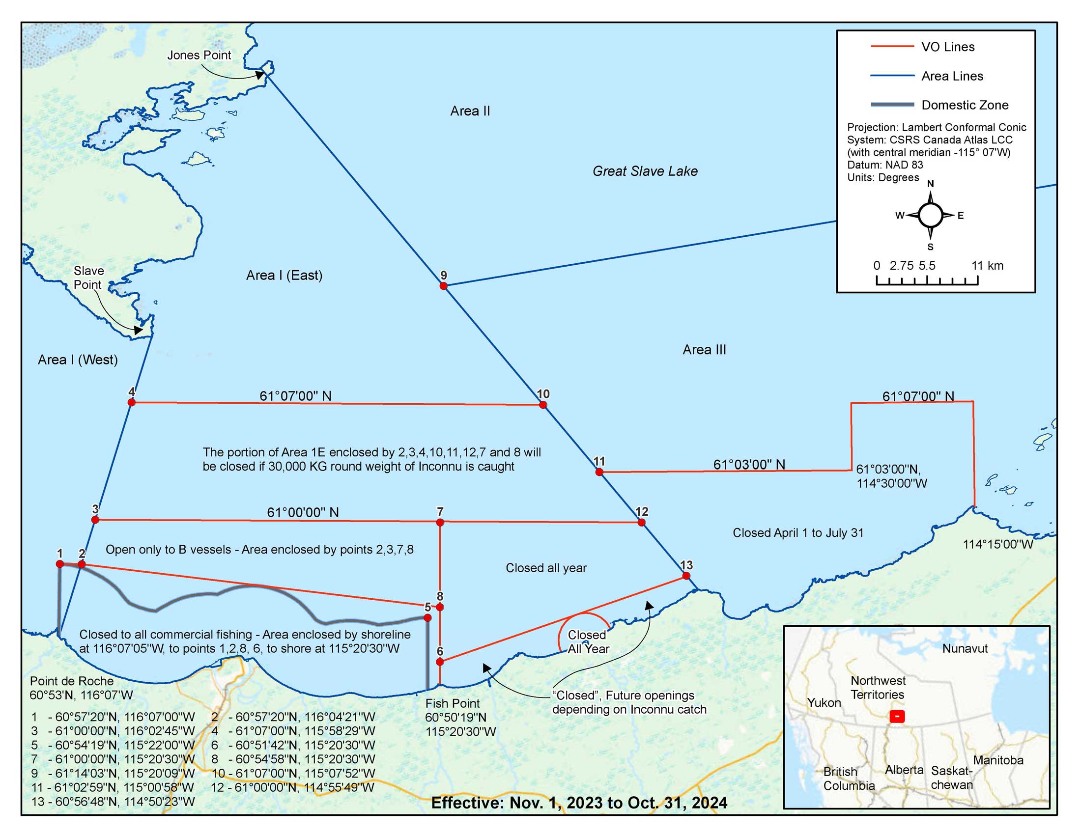
Figure 2. The commercial fishing management areas, variation order zones and Hay River domestic zone in the western basin of Great Slave Lake south of Jones Point and west of the Little Buffalo River.
Long Description
Figure 2 is a map of the portion of Great Slave Lake south of Jones Point and west of the Little Buffalo River. The map is mostly light in color with Great Slave Lake and surrounding waterbodies indicated by light blue and major highways by thin orange lines.
Thick blue lines indicate the offshore limit of the Hay River domestic fishing zone, thin blue lines indicate the commercial fishing management areas of Great Slave Lake, and thin red lines indicate zones within each management area that has specific regulations controlled by variation order. The management zones are labelled with text near the central portion of each zone and include the text 1W and 1E as well as Roman numerals 2 and 3, the zones are labelled progressing left to right from 1W to roman numeral 2 and 3.
An inset in the lower right corner shows a large-area view of western Canada with provincial and territorial labels overlaid by a red box that indicates the portion of covered by the main map that shows the Great Slave Lake west basin.
Another inset in the upper right corner contains a legend that shows the line styles for variation order zones, management areas, and domestic zones. This inset also includes the text describing the map projection, datum and map units as well as a compass rose and scale bar. The projection is listed as the Lambert Conformal Conic Projection based on the CSRS Canada Atlas LCC with a central meridian of 115 degrees and 7 minutes West, the datum is NAD 83 and the map units are in degrees. Below this is the compass rose and a scale bar in kilometre units.
Several text labels on the map of Great Slave Lake are present including:
- bold text at the centre bottom of the map states the map is effective from Nov. 1, 2023 to Oct. 31, 2024; the map is reviewed and updated for the start of every fishing season before November 1st.
- text labels for the management areas are written using roman numerals for the numeric part of the label and located near the centre of each of those areas. The four areas labelled from left to right on the map are area 1 west, right of that is area 1 east, above and to the right of that is area 2, and below that area is area 3.
- a text label and arrow pointing to the locations of Slave Point and Jones Point are shown in the upper left portion of map.
- a text label for Point de Roche below it's location in the lower left portion of the map along the south shoreline of Great Slave Lake includes the name as well as the geographic coordinates of 60 degrees 53 minutes north and 116 degrees 7 minutes west.
- a text label for Fish Point below it’s location near the centre lower portion of the map along the south shoreline of Great Slave Lake. The geographic coordinates for this location are 60 degrees 50 minutes 19 seconds north and 115 degrees 20 minutes 30 seconds west.
- area 3 has a variation order zone indicated by a thin red line in it’s lower portion along the south shoreline of Great Slave Lake. This zone has a text label at the bottom of its rightmost longitude limit on the shoreline of Great Slave Lake that states the longitude geographic coordinate of 114 degrees and 15 minutes west. The zone has two latitude limits along it's northern boundary labelled with the geographic coordinates, the lower one is 61 degrees 3 minutes north and the upper one is 61 degrees 7 minutes north. This zone has a vertical line of longitude connecting these two limits at longitude 114 degrees 30 minutes west labelled with that text. Near the centre of this zone is a text label stating closed April 1 to July 31.
- management area 1 east is subdivided into 6 sub areas equating to various variation order zones. The upper most of these zones is delimited by two thin red lines running left to right across the entire horizontal extent of the area. The uppermost line is labelled with text describing the latitude of 61 degrees 7 minutes north. The lowermost line is labelled with text describing the latitude of 61 degrees north. In addition, there is an interior text label near the centre of the zone that states the portion of area 1 E enclosed by points 2, 3, 4, 10, 11, 12, 7 and 8 will be closed once 30,000 kg round weight of inconnu is caught.
- below this variation order are two zones, one on the left (we'll call this A) and one on the right side of this management zone. The left most area has a label in the centre with the text stating open only to B vessels and the area is enclosed by points 2, 3, 7, and 8.
- to the right of this variation order zone is the other zone with a central text label that states closed all year. There is not text stating this this zone is enclosed by lines between points 7, 12, 13, 6, and 8. The rightmost boundary of this zone is the eastern boundary of management area 1 east. the leftmost boundary of this zone is the line of longitude at Fish Point described earlier.
- below this variation order zone are two more variaton order zones adjacent to the southern Great Slave Lake shoreline. One zone is a semicircle centred at the mouth of the Buffalo River, the other zone is located either side of this semi circle and whose upper boundary is defined by points 6 and 13. A text label stating closed all year is located within the semi circle. Another text label stating closed with future openings depending on inconnu catch is located below both of these zones on the southern Great Slave Lake shoreline. This text label has two arrows that point to each side of this zone located left and right of the semi circle. The rightmost boundary of this zone is the east boundary of area 1 east. The leftmost boundary of this zone is the line of longitude at Fish Point that was mentioned earlier.
- below the variation order zone we said we'd call A is another variation order zone that is adjacent to the southern shoreline of Great Slave Lake. This zone is mostly in area 1 east with a very small portion in area 1 west. This area also completely contains the Hay River domestic zone that is enclosed by a thick blue line that is sinuous and parallels the southern shoreline of Great Slave Lake 8 kilometres south. The left and right limit of this domestic zone are vertical lines to the southern shoreline. This variation order zone is delimited by points and has an interior text label that states closed to all commercial fishing - area enclosed by shoreline at 116 degrees 7 minutes 5 seconds west to points 1, 2, 8, 6, then to shore at longitude 115 degrees 20 minutes 30 seconds west.
- the final text block is located in the lower left corner of the map below the shoreline of Great Slave Lake. This text block is a list of geographic coordinates that relate the point numbering on the map along various boundaries to their geographic coordinates. This text block states that point 1 is at 60 degrees 57 minutes 20 seconds north 116 degrees 7 minutes west, point 2 is at 60 degrees 57 minutes 20 seconds north 116 degrees 4 minutes 21 seconds west, point 3 is at 61 degrees north 116 degrees 2 minutes 45 seconds west, point 4 is at 61 degrees 7 minutes north 115 degrees 58 minutes 29 seconds west, point 5 is at 60 degrees 54 minutes 19 seconds north 115 degrees 22 minutes west, point 6 is at 60 degrees 51 minutes 42 seconds north 115 degrees 20 minutes 30 seconds west, point 7 is at 61 degrees north 115 degrees 20 minutes 30 seconds west, point 8 is at 60 degrees 54 minutes 58 seconds north 115 degrees 20 minutes 30 seconds west, point 9 is at 61 degrees 14 minutes 3 seconds north 115 degrees 20 minutes 9 seconds west, point 10 is at 61 degrees 7 minutes north 115 degrees 7 minutes 52 seconds west, point 11 is at 61 degrees 2 minutes 59 seconds north 115 degrees 0 minutes 58 seconds west, point 12 is at 61 degrees north 114 degrees 55 minutes 49 seconds west, and finally point 13 is at 60 degrees 56 minutes 48 seconds north 114 degrees 50 minutes 23 seconds west.
Consultations
Contacts
- Date modified: