
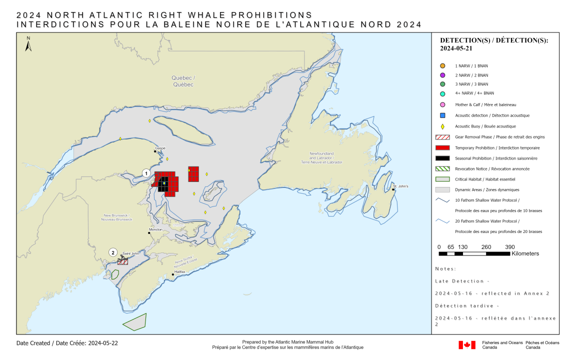
North Atlantic Right Whale - Notice of temporary prohibited fishing grid(s) HO23, HO24, HO25, HP23, HP24, HP25 and Notice of seasonally prohibited fishing grid(s) GY35, GY36, GY37, GZ35, GZ36, GZ37, HA35, HA36, HA37
May 22, 2024 – Fisheries and Oceans Canada (DFO) is providing notice of grid status updates related to North Atlantic Right Whale (NARW). The information presented herein is consistent with the 2024 NARW management measures previously announced by DFO.
All times listed in this document are in Atlantic Daylight Time (ADT).
New updates are in effect in the following waters (refer to the corresponding annex for details):
- New seasonally prohibited fishing grid(s) in the Gulf of St Lawrence - Annex 1
- New prohibited fishing grid(s) in the Bay of Fundy - Annex 2
All NARW related prohibited fishing grids currently in effect in Canadian waters are provided in the following corresponding annexes:
- Annex 1 – for the Gulf of St Lawrence
- Annex 2 – for the Bay of Fundy
- Annex 3 – for the Roseway Basin Critical Habitat
- Annex 4 – for all waters outside of the dynamic or critical habitat areas
DFO asks licence holders to be vigilant during fishing activities concerning the presence of NARW. Furthermore, please be reminded that it is the responsibility of the licence holder and operator to take into account the marine safety notices issued, amongst others, by Environment and Climate Change Canada and Transport Canada, as well as the standards and best practices in marine safety, and to take all measures to ensure safe fishing operations.
Any reference to the term "Notice" in this document means this "Notice to Fish Harvesters". The Notice to Fish Harvesters, including its annexes, is provided for information purposes only. In case of discrepancy between the information in the Notice to Fish Harvester and the Notice on the Orders Registry System, the latter will prevail. For more detailed information please visit the order registry for your region.
Coordinates
| Points | Position* | |
|---|---|---|
| North Latitude (N) | West Longitude (W) | |
| 1 | 48° 10' 00.00" | 64° 30' 00.00" |
| 2 | 48° 10' 00.00" | 63° 30' 00.00" |
| 3 | 48° 00' 00.00" | 63° 30' 00.00" |
| 4 | 48° 00' 00.00" | 63° 20' 00.00" |
| 5 | 47° 30' 00.00" | 63° 20' 00.00" |
| 6 | 47° 30' 00.00" | 63° 30' 00.00" |
| 7 | 47° 20' 00.00" | 63° 30' 00.00" |
| 8 | 47° 20' 00.00" | 64° 00' 00.00" |
| 9 | 47° 30' 00.00" | 64° 00' 00.00" |
| 10 | 47° 30' 00.00" | 64° 20' 00.00" |
| 11 | 47° 40' 00.00" | 64° 20' 00.00" |
| 12 | 47° 40' 00.00" | 64° 40' 00.00" |
| 13 | 47° 45' 10.52" | 64° 40' 00.00" |
| 14 | 47° 45' 10.17" | 64° 39' 57.62" |
| 15 | 47° 44' 49.37" | 64° 39' 15.14" |
| 16 | 47° 43' 55.61" | 64° 38' 55.66" |
| 17 | 47° 45' 55.28" | 64° 35' 36.59" |
| 18 | 47° 48' 25.87" | 64° 32' 20.15" |
| 19 | 47° 49' 45.41" | 64° 31' 08.08" |
| 20 | 47° 50' 00.00" | 64° 30' 58.63" |
| 21 | 47° 50' 00.00" | 64° 30' 00.00" |
| 22 | 47° 53' 16.90" | 64° 30' 00.00" |
| 23 | 47° 53' 33.93" | 64° 29' 56.01" |
| 24 | 47° 54' 38.23" | 64° 29' 32.43" |
| 25 | 47° 55' 59.39" | 64° 28' 43.21" |
| 26 | 47° 56' 16.09" | 64° 28' 37.35" |
| 27 | 47° 56' 39.82" | 64° 28' 38.81" |
| 28 | 47° 55' 15.28" | 64° 30' 00.00" |
| 29 | 47° 55' 59.64" | 64° 30' 00.00" |
| 30 | 47° 56' 28.39" | 64° 29' 14.70" |
| 31 | 47° 57' 48.08" | 64° 28' 20.65" |
| 32 | 47° 58' 51.36" | 64° 28' 22.85" |
| 33 | 47° 59' 54.06" | 64° 28' 48.19" |
| 34 | 48° 01' 12.28" | 64° 29' 03.42" |
| 35 | 48° 01' 41.09" | 64° 30' 00.00" |
| 36 | 48° 10' 00.00" | 64° 30' 00.00" |
| Points | Position* | |
|---|---|---|
| North Latitude (N) | West Longitude (W) | |
| 1 | 48° 20' 00.00" | 62° 50' 00.00" |
| 2 | 48° 20' 00.00" | 62° 20' 00.00" |
| 3 | 47° 50' 00.00" | 62° 20' 00.00" |
| 4 | 47° 50' 00.00" | 62° 50' 00.00" |
| 5 | 48° 20' 00.00" | 62° 50' 00.00" |
| Points | Position* | |
|---|---|---|
| North Latitude (N) | West Longitude (W) | |
| 1 | 45° 20' 00.00" | 66° 11' 46.52" |
| 2 | 45° 20' 00.00" | 66° 05' 57.47" |
| 3 | 45° 14' 22.02" | 65° 50' 00.00" |
| 4 | 45° 00' 00.00" | 65° 50' 00.00" |
| 5 | 45° 00' 00.00" | 66° 20' 00.00" |
| 6 | 45° 08' 43.02" | 66° 20' 00.00" |
| 7 | 45° 20' 00.00" | 66° 11' 46.52" |
* Area enclosed by rhumb lines (similar to straight lines plotted on a nautical chart) joining the points listed above in the order they are listed. Point references are based on the geodesic system North American Datum 1983 (NAD83). Positions are expressed in degrees, minutes and seconds.
(The above maps have no legal bearing and are provided for visual reference only.)
For more information
Please visit the interactive map on the latest right whale observations for regular updates.
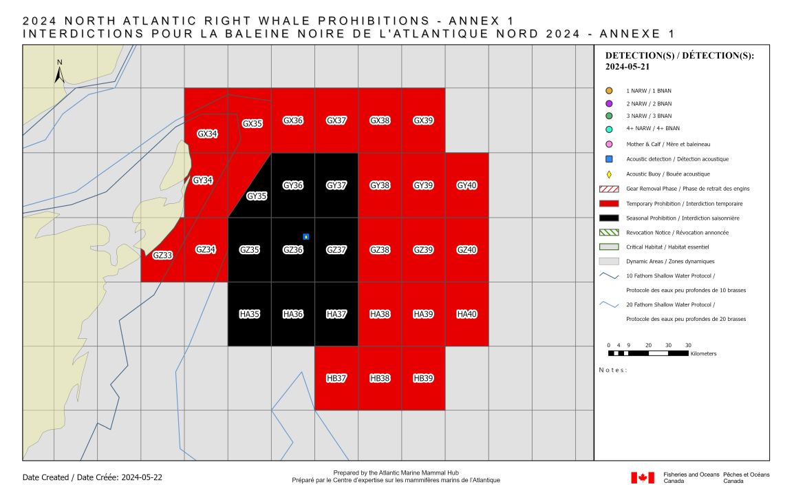
Annex 1 – Gulf of St Lawrence – NARW related fishing prohibitions in effect
New information related to prohibited fishing grid(s)
Due to a repeat detection within days nine to fifteen of a 15 day dynamic fishing prohibition period, the following grid(s) will be placed into a seasonally prohibited fishing status starting today until November 15, 2024:
- Full grid(s): GY36, GY37, GZ35, GZ36, GZ37, HA35, HA36, HA37
- Portion of grid(s): GY35*
*Portion of grid in water deeper than 20 fathoms
Previously announced fishing prohibitions
The following grid(s) are temporarily prohibited for fishing until further notice in the Gulf of St Lawrence:
- Full grid(s): GW44, GW45, GW46, GX34, GX35, GX36, GX37, GX38, GX39, GX44, GX45, GX46, GY34, GY38, GY39, GY40, GY44, GY45, GY46, GZ34, GZ38, GZ39, GZ40, HA38, HA39, HA40, HB37, HB38, HB39
- Portion of grid(s): GY35*, GZ33
*Portion of the grid in water shallower than 20 fathoms
The fishing prohibitions are in effect for the following fisheries when the fishing seasons are open in the Gulf, Newfoundland & Labrador, and Quebec Regions:
- Snow crab
- Toad crab
- Rock crab
- Lobster
- Whelk
- Greenland halibut (fixed gear)
- Winter flounder (fixed gear)
- Bait (fixed gear)
- Sea urchin (fixed gear)
- Herring (trap net)
The fishing prohibitions will also be in effect for Atlantic halibut (fixed gear), mackerel (gillnet) and herring (gillnet) when gear is left unattended.
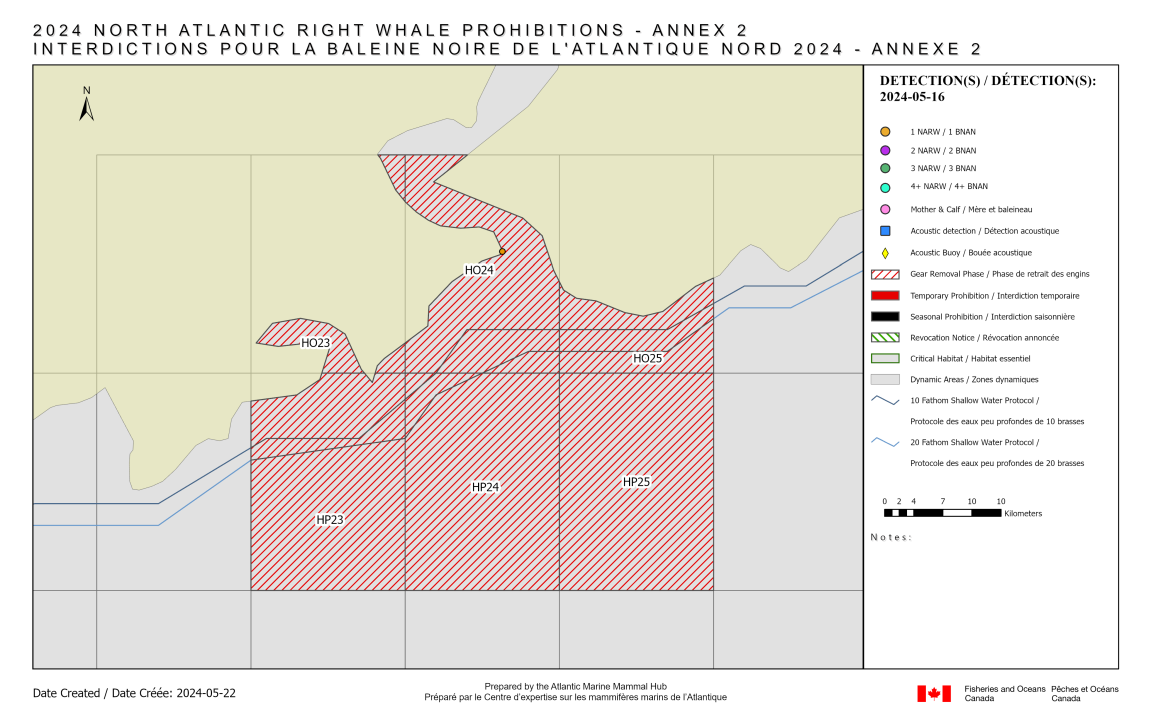
Annex 2 – Bay of Fundy – NARW related fishing prohibitions in effect
New information related to prohibited fishing grid(s)
Fishing prohibition(s) for the following grid(s) will commence on May 25, 2024 at 5:00 p.m.:
- Full grid(s): HP24, HP25
- Portion of grid(s): HO23, HO24, HO25, HP23
DFO is providing a 72-hour delay for the above prohibited fishing grid(s) due to the weather forecast. All affected gear must be removed from the prohibited fishing area before the specified time, and no new gear is permitted to be set in the water after the notice is issued.
The fishing prohibitions are in effect for the following fisheries when the fishing seasons are open in the Maritimes Region:
- Crab
- Herring (gillnet)
- Mackerel (gillnet)
- Groundfish (gillnet)
- Shrimp (trap)
- Hagfish
- Whelk
- Lobster
The fishing prohibitions are also in effect for groundfish (longline) when gear is left unattended.
Annex 3 – Roseway Basin Critical Habitat – NARW related fishing prohibitions in effect
There are no prohibited fishing grids related to NARW in the Roseway Basin Critical Habitat.
Annex 4 – Outside of the dynamic and critical habitat areas – NARW related fishing prohibitions in effect
There are no prohibited fishing grids related to NARW in the waters outside of the dynamic and critical habitat areas.
- Date modified: