
Strait of Georgia and Howe Sound Glass Sponge Reef Conservation Initiative
Note:
The charts and diagrams below are provided for information only and should not be used for fishing, navigation or other purposes.
British Columbia's ancient glass sponge reefs are a globally unique ecosystem that are areas of high biodiversity and provide important habitat for many marine animals including salmon, spot prawns, rockfish, herring, halibut and sharks. Through the Strait of Georgia and Howe Sound Conservation Initiative, we have put in place measures to protect and conserve glass sponge reefs on British Columbia's south coast.
Glass Sponge Reef Marine Refuges – Strait of Georgia
No commercial, recreational or Indigenous Food, Social and Ceremonial bottom-contact fishing activities are allowed within the areas listed below. Full coordinates can be found in FN0571. This includes fishing for:
- prawn
- shrimp
- crab
- groundfish (including halibut)
Foreslope Hills
That portion of Subarea 29-3 that lies inside a line that:
| begins at | 49°09.634'N | 123°23.048'W |
| then southeasterly to | 49°09.389'N | 123°22.622'W |
| then southerly to | 49°09.187'N | 123°22.587'W |
| then westerly to | 49°09.211'N | 123°23.567'W |
| then northerly to | 49°09.646'N | 123°23.543'W |
| then to the beginning point | 49°09.634'N | 123°23.048'W |

Click to enlarge.
Outer Gulf Islands
Those portions of Subareas 18-1 and 29-4 that lie inside the following lines that:
| begin at | 48°54.936'N | 123°19.589'W |
| then southerly to | 48°54.283'N | 123°18.529'W |
| then southwesterly to | 48°54.114'N | 123°18.619'W |
| then southwesterly to | 48°54.065'N | 123°18.771'W |
| then northwesterly to | 48°54.787'N | 123°19.929'W |
| then northeasterly to | 48°54.902'N | 123°19.793'W |
| then to the beginning point | 48°54.936'N | 123°19.589'W |
| begin at | 48°52.588'N | 123°15.261'W |
| then easterly to | 48°52.520'N | 123°14.537'W |
| then northwesterly to | 48°51.971'N | 123°13.768'W |
| then southwesterly to | 48°51.795'N | 123°13.947'W |
| then southeasterly to | 48°52.150'N | 123°14.444'W |
| then southwesterly to | 48°52.038'N | 123°14.678'W |
| then northeasterly to | 48°52.479'N | 123°15.521'W |
| then to the beginning point | 48°52.588’N | 123°15.261’W |
| begin at | 48°51.602'N | 123°13.233'W |
| then southerly to | 48°51.309'N | 123°12.751'W |
| then northwesterly to | 48°50.913'N | 123°12.938'W |
| then southeasterly to | 48°50.844'N | 123°13.059'W |
| then southwesterly to | 48°51.163'N | 123°13.662'W |
| then northeasterly to | 48°51.579'N | 123°13.378'W |
| then to the beginning point | 48°51.602'N | 123°13.233'W |
| begin at | 48°50.999'N | 123°12.391'W |
| then southerly to | 48°50.608'N | 123°11.603'W |
| then southwesterly to | 48°50.097'N | 123°10.956'W |
| then northeasterly to | 48°49.959'N | 123°11.182'W |
| then southwesterly to | 48°50.857'N | 123°12.654'W |
| then northeasterly to | 48°50.959'N | 123°12.566'W |
| then to the beginning point | 48°50.999'N | 123°12.391'W |

Click to enlarge.
Gabriola Island
That portion of Subarea 17-11 that lies inside a line that:
| begins at | 49°13.672'N | 123°47.577'W |
| then southerly to | 49°13.235'N | 123°47.429'W |
| then westerly to | 49°13.185'N | 123°47.882'W |
| then northwesterly to | 49°13.391'N | 123°48.119'W |
| then northerly to | 49°13.623'N | 123°48.166'W |
| then to the beginning point | 49°13.672'N | 123°47.577'W |

Click to enlarge.
Parksville
Those portions of Subareas 14-2 and 14-3 that lie inside a line that:
| begins at | 49°21.680'N | 124°19.762'W |
| then southeasterly to | 49°21.514'N | 124°18.893'W |
| then southeasterly to | 49°21.191'N | 124°17.723'W |
| then southerly to | 49°21.064'N | 124°17.724'W |
| then southwesterly to | 49°20.725'N | 124°18.380'W |
| then northwesterly to | 49°21.432'N | 124°19.811'W |
| then to the beginning point | 49°21.680'N | 124°19.762'W |

Click to enlarge.
East of Hornby Island
That portion of Subarea 14-6 that lies inside a line that:
| begins at | 49°33.490'N | 124°29.230'W |
| then southerly to | 49°32.701'N | 124°28.760'W |
| then southwesterly to | 49°31.657'N | 124°29.434'W |
| then westerly to | 49°31.663'N | 124°29.896'W |
| then northerly to | 49°32.651'N | 124°29.752'W |
| then northerly to | 49°33.340'N | 124°29.935'W |
| then northeasterly to | 49°33.498'N | 124°29.773'W |
| then to the beginning point | 49°33.490'N | 124°29.230'W |

Click to enlarge.
Sechelt
That portion of Subarea 29-2 that lies inside a line that:
| begins at | 49°25.948'N | 123°48.889'W |
| then easterly to | 49°25.899'N | 123°47.266'W |
| then southeasterly to | 49°25.373'N | 123°46.494'W |
| then southwesterly to | 49°24.734'N | 123°47.083'W |
| then westerly to | 49°24.910'N | 123°47.951'W |
| then southerly to | 49°24.253'N | 123°48.283'W |
| then northwesterly to | 49°24.845'N | 123°49.914'W |
| then to the beginning point | 49°25.948'N | 123°48.889'W |
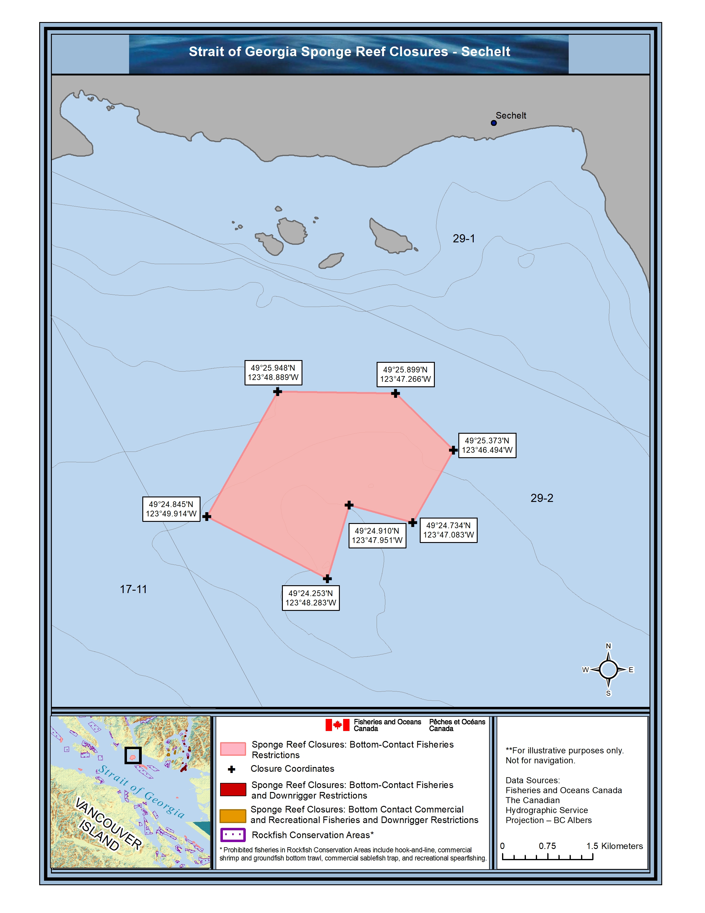
Click to enlarge.
Halibut Bank
That portion of Subarea 29-2 that lie inside a line that:
| begins at | 49°21.768'N | 123°41.501'W |
| then southerly to | 49°21.174'N | 123°40.045'W |
| then southerly to | 49°20.961'N | 123°40.139'W |
| then southeasterly to | 49°20.803'N | 123°39.860'W |
| then southwesterly to | 49°20.565'N | 123°40.182'W |
| then northwesterly to | 49°21.610'N | 123°41.843'W |
| then westerly to | 49°21.673'N | 123°42.643'W |
| then northwesterly to | 49°21.895'N | 123°43.908'W |
| then northwesterly to | 49°22.174'N | 123°44.748'W |
| then northeasterly to | 49°22.555'N | 123°44.456'W |
| then easterly to | 49°22.188'N | 123°42.167'W |
| then to the beginning point | 49°21.768'N | 123°41.501'W |

Click to enlarge.

Strait of Georgia Glass Sponge Reef Marine Refuges
Glass Sponge Reef Marine Refuges – Howe Sound
No commercial, recreational or Indigenous bottom-contact Food, Social and Ceremonial fishing activities are allowed within the areas listed below. Full coordinates can be found in FN0205. Defence Islands and Queen Charlotte Sound coordinates can be found in FN0571. This includes fishing for:
- prawn
- shrimp
- crab
- groundfish (including halibut)
The use of downrigger gear in recreational salmon trolling is also prohibited in these areas (except Defence Islands) due to the potential risk of damage to shallow reefs.
Defence Islands
That portion of Subarea 28-4 that lies inside a line that:
| begins at | 49°34.102'N | 123°17.070'W |
| then southerly to | 49°33.730'N | 123°16.562'W |
| then southeasterly to | 49°33.553'N | 123°16.462'W |
| then southwesterly to | 49°33.438'N | 123°16.750'W |
| then northwesterly to | 49°33.707'N | 123°17.201'W |
| then northwesterly to | 49°33.993'N | 123°17.391'W |
| then to the beginning point | 49°34.102'N | 123°17.070'W |

Click to enlarge.
East Defence Islands
That portion of Subarea 28-4 that lies inside a line that:
| begins at | 49° 34.731' N | 123° 16.555' W |
| then northeasterly to | 49° 34.848' N | 123° 16.357' W |
| then northeasterly to | 49° 34.854' N | 123° 16.120' W |
| then southeasterly to | 49° 34.580' N | 123° 16.084' W |
| then southwesterly to | 49° 34.535' N | 123° 16.539' W |
| then to the beginning point | 49° 34.731' N | 123° 16.555' W |

Click to enlarge.
Anvil Island
That portion of Subarea 28-4 that lies inside a line that:
| begins at | 49° 32.874' N | 123° 17.425' W |
| then southeasterly to | 49° 32.865' N | 123° 16.815' W |
| then southwesterly to | 49° 32.533' N | 123° 16.869' W |
| then southwesterly to | 49° 32.482' N | 123° 17.118' W |
| then northwesterly to | 49° 32.574' N | 123° 17.483' W |
| then to the beginning point | 49° 32.874' N | 123° 17.425' W |

Click to enlarge.
Lost Reef
That portion of Subarea 28-2 that lies inside a line that:
| begins at | 49° 29.799' N | 123° 18.203' W |
| then northeasterly to | 49° 29.935' N | 123° 18.007' W |
| then southeasterly to | 49° 29.882' N | 123° 17.832' W |
| then southeasterly to | 49° 29.591' N | 123° 17.519' W |
| then southwesterly to | 49° 29.547' N | 123° 17.941' W |
| then to the beginning point | 49° 29.799' N | 123° 18.203' W |

Click to enlarge.
Brunswick Point
That portion of Subarea 28-2 that lies inside a line that:
| begins at | 49° 28.577' N | 123° 14.965' W |
| then southeasterly to | 49° 28.434' N | 123° 14.732' W |
| then southwesterly to | 49° 28.177' N | 123° 15.031' W |
| then northwesterly to | 49° 28.397' N | 123° 15.377' W |
| then to the beginning point | 49° 28.577' N | 123° 14.965' W |

Click to enlarge.
Lions Bay and Kelvin Grove
That portion of Subarea 28-2 that lies inside a line that:
| begins at | 49° 27.629' N | 123° 15.761' W |
| then southeasterly to | 49° 27.315' N | 123° 14.516' W |
| then southwesterly to | 49° 26.950' N | 123° 14.595' W |
| then northwesterly to | 49° 26.952' N | 123° 15.046' W |
| then northwesterly to | 49° 27.195' N | 123° 15.655' W |
| then to the beginning point | 49° 27.629' N | 123° 15.761' W |

Click to enlarge.
Halkett Point
That portion of Subarea 28-2 that lies inside a line that:
| begins at | 49° 27.036' N | 123° 18.686' W |
| then southeasterly to | 49° 26.897' N | 123° 18.444' W |
| then southwesterly to | 49° 26.696' N | 123° 18.578' W |
| then southwesterly to | 49° 26.657' N | 123° 18.776' W |
| then northwesterly to | 49° 26.742' N | 123° 18.984' W |
| then to the beginning point | 49° 27.036' N | 123° 18.686' W |

Click to enlarge.
Bowyer Island
That portion of Subarea 28-2 that lies inside a line that:
| begins at | 49° 24.774' N | 123° 16.219' W |
| then northeasterly to | 49° 24.820' N | 123° 15.763' W |
| then southwesterly to | 49° 24.096' N | 123° 16.043' W |
| then northwesterly to | 49° 24.389' N | 123° 16.408' W |
| then to the beginning point | 49° 24.774' N | 123° 16.219' W |

Click to enlarge.
Dorman Point
That portion of Subarea 28-2 that lies inside a line that:
| begins at | 49° 22.577' N | 123° 19.379' W |
| then southeasterly to | 49° 22.543' N | 123° 19.051' W |
| then southwesterly to | 49° 22.287' N | 123° 19.152' W |
| then northwesterly to | 49° 22.351' N | 123° 19.454' W |
| then to the beginning point | 49° 22.577' N | 123° 19.379' W |

Click to enlarge.
Howe Sound – Queen Charlotte Channel
Those portions of Subareas 28-2 and 29-3 that lie inside the following lines that:
| begin at | 49°21.486'N | 123°17.254'W |
| then southerly to | 49°20.528'N | 123°17.690'W |
| then southwesterly to | 49°20.401'N | 123°17.956'W |
| then northeasterly to | 49°20.765'N | 123°18.794'W |
| then northwesterly to | 49°20.982'N | 123°18.584'W |
| then southeasterly to | 49°21.098'N | 123°18.037'W |
| then northwesterly to | 49°21.501'N | 123°17.737'W |
| then to the beginning point | 49°21.486'N | 123°17.254'W |
| begin at | 49°20.288'N | 123°17.693'W |
| then southeasterly to | 49°20.224'N | 123°17.501'W |
| then northeasterly to | 49°19.993'N | 123°17.377'W |
| then southwesterly to | 49°19.802'N | 123°17.444'W |
| then southwesterly to | 49°19.720'N | 123°17.840'W |
| then northeasterly to | 49°19.937'N | 123°18.107'W |
| then to the beginning point | 49°20.288’N | 123°17.693’W |
| begin at | 49°19.918'N | 123°19.847'W |
| then southerly to | 49°19.296'N | 123°19.905'W |
| then easterly to | 49°19.307'N | 123°20.344'W |
| then northwesterly to | 49°19.643'N | 123°20.421'W |
| then northeasterly to | 49°19.819'N | 123°20.361'W |
| then northeasterly to | 49°19.947'N | 123°20.097'W |
| then to the beginning point | 49°19.918’N | 123°19.847’W |
| begin at | 49°20.637'N | 123°19.162'W |
| then easterly to | 49°20.577'N | 123°18.720'W |
| then southeasterly to | 49°20.441'N | 123°18.637'W |
| then southwesterly to | 49°20.068'N | 123°18.818'W |
| then easterly to | 49°20.076'N | 123°19.135'W |
| then northerly to | 49°19.718'N | 123°19.187'W |
| then westerly to | 49°19.726'N | 123°19.514'W |
| then southwesterly to | 49° 20.259'N | 123°19.828'W |
| then to the beginning point | 49°20.637'N | 123°19.162'W |

Click to enlarge.

Howe Sound Glass Sponge Reef Marine Refuges
Glass Sponge Reef Fishery Closures – Howe Sound
Fisheries closures are currently in place to protect and conserve 5 glass sponge reefs in Howe Sound, with the aim of creating marine refuges in the future. No commercial or recreational bottom-contact fishing activities are allowed within the areas listed below. Full coordinates can be found in FN0039. This includes fishing for:
- prawn
- shrimp
- crab
- groundfish (including halibut)
The use of downrigger gear in recreational salmon trolling is also prohibited in these areas due to the potential risk of damage to shallow reefs.
Alberta Bay
That portion of Subarea 28-2 that lies inside a line that:
| begins at | 49⁰ 28.118’N | 123⁰ 15.050’W |
| then easterly to | 49⁰ 28.130’N | 123⁰ 14.688’W |
| then southeasterly to | 49⁰ 27.962’N | 123⁰ 14.600’W |
| then southeasterly to | 49⁰ 27.646’N | 123⁰ 14.518’W |
| then southwesterly to | 49⁰ 27.520’N | 123⁰ 14.646’W |
| then westerly to | 49⁰ 27.523’N | 123⁰ 15.008’W |
| then northwesterly to | 49⁰ 27.904’N | 123⁰ 15.118’W |
| then to the beginning point | 49⁰ 28.118’N | 123⁰ 15.050’W |
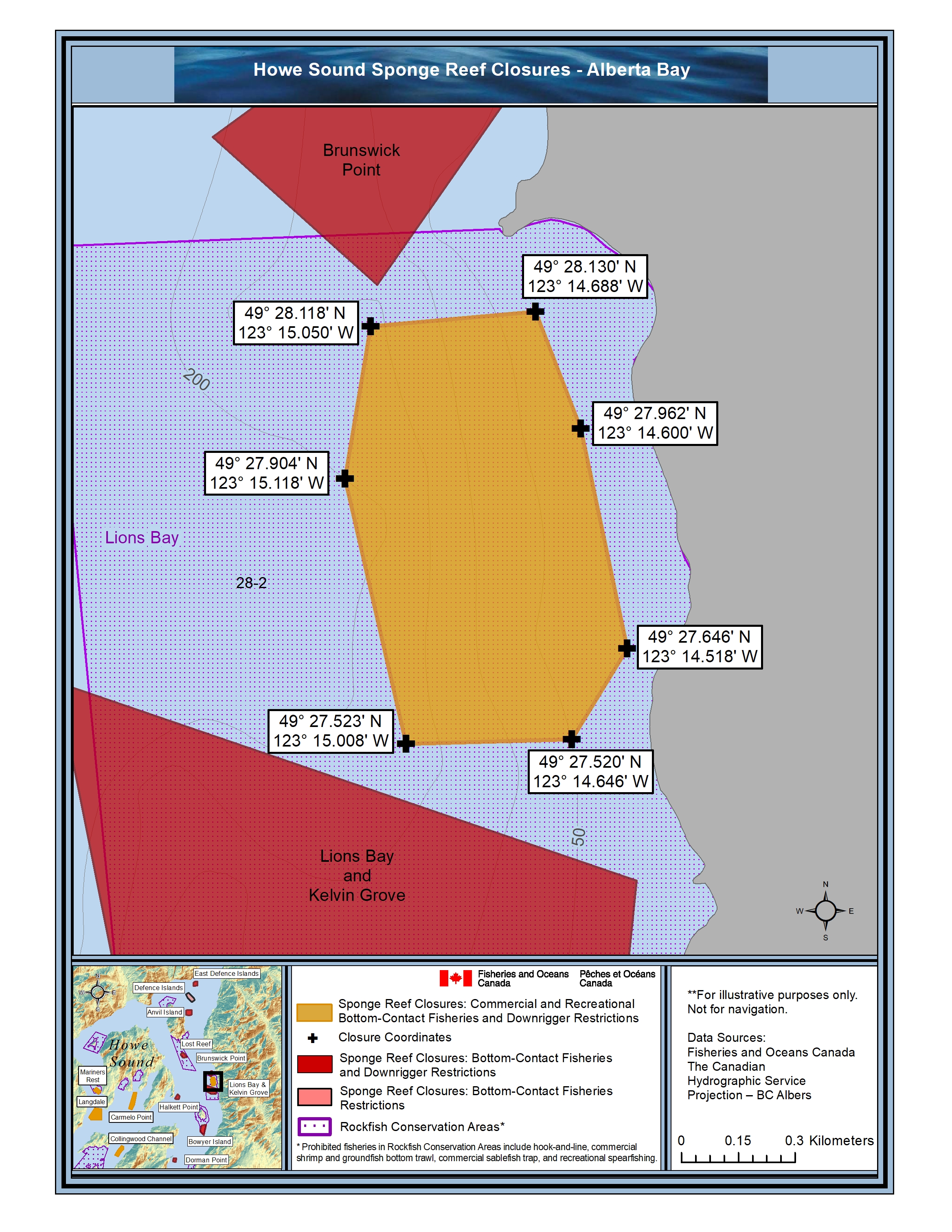
Click to enlarge.
Carmelo Point
That portion of Subarea 28-1 that lies inside a line that:
| begins at | 49⁰ 27.253’N | 123⁰ 23.398’W |
| then easterly to | 49⁰ 27.259’N | 123⁰ 23.028’W |
| then southwesterly to | 49⁰ 26.390’N | 123⁰ 23.315’W |
| then southwesterly to | 49⁰ 26.043’N | 123⁰ 23.610’W |
| then northwesterly to | 49⁰ 26.136’N | 123⁰ 24.003’W |
| then to the beginning point | 49⁰ 27.253’N | 123⁰ 23.398’W |

Click to enlarge.
Langdale
That portion of Subarea 28-1 and 28-3 that lines inside a line that:
| begins at | 49⁰ 26.283’N | 123⁰ 27.605’W |
| then southeasterly to | 49⁰ 26.196’N | 123⁰ 26.895’W |
| then southerly to | 49⁰ 25.398’N | 123⁰ 26.890’W |
| then westerly to | 49⁰ 25.431’N | 123⁰ 28.034’W |
| then northwesterly to | 49⁰ 25.634’N | 123⁰ 28.291’W |
| then to the beginning point | 49⁰ 26.283’N | 123⁰ 27.605’W |

Click to enlarge.
Mariners Rest
That portion of Subarea 28-3 that lies inside a line that:
| begins at | 49⁰ 27.728’N | 123⁰ 27.357’W |
| then southeasterly to | 49⁰ 27.439’N | 123⁰ 26.871’W |
| then southwesterly to | 49⁰ 27.212’N | 123⁰ 27.139’W |
| then northwesterly to | 49⁰ 27.508’N | 123⁰ 27.706’W |
| then to the beginning point | 49⁰ 27.728’N | 123⁰ 27.357’W |

Click to enlarge.
Collingwood Channel
That portion of Subarea 28-1 that lies inside a line that:
| begins at | 49⁰ 23.503’N | 123⁰ 24.638’W |
| then southeasterly to | 49⁰ 23.347’N | 123⁰ 24.625’W |
| then southwesterly to | 49⁰ 23.068’N | 123⁰ 25.030’W |
| then southwesterly to | 49⁰ 22.921’N | 123⁰ 25.145’W |
| then southwesterly to | 49⁰ 22.799’N | 123⁰ 25.296’W |
| then northwesterly to | 49⁰ 22.947’N | 123⁰ 25.655’W |
| then northeasterly to | 49⁰ 23.280’N | 123⁰ 25.346’W |
| then northeasterly to | 49⁰ 23.602’N | 123⁰ 24.885’W |
| then to the beginning point | 49⁰ 23.503’N | 123⁰ 24.638’W |

Click to enlarge.
- Date modified: