
Tang.ɢ̱wan – ḥačxwiqak – Tsig̱is Marine Protected Area (TḥT MPA)
We would like to give acknowledgement and gratitude to the following for sharing their languages with us:
- Recording of Tang.ɢ̱wan provided by: Haida speaker Taalgyaa'adad Betty Richardson
- Recording of ḥačxwiqak provided by: Elder Tom Curly
- Recording of Tsig̱is provided by: Cultural teacher Zach Taylor
Pronunciation recording
Note:
Charts, diagrams and contact information on this website are provided for information purposes only and should not be used for fishing, navigation or other purposes. Please refer to the MPA Regulations or contact your regional Fisheries and Oceans Canada office for official coordinates.
On this page
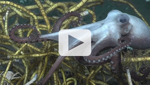
Video: Tang.ɢ̱wan – ḥačxwiqak – Tsig̱is - Marine Protected Area
At-a-glance
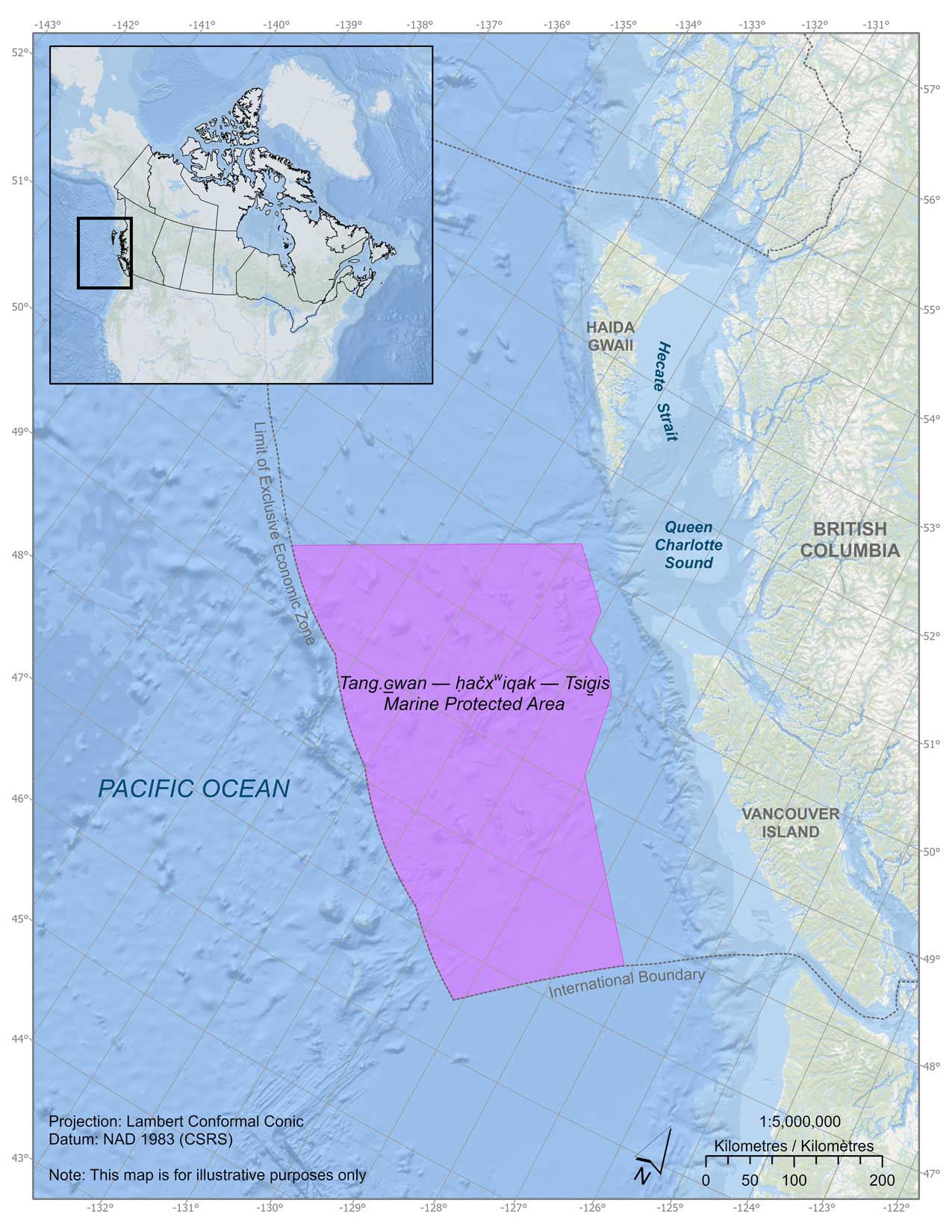
Map: Tang.ɢ̱wan – ḥačxwiqak – Tsig̱is Marine Protected Area (TḥT MPA)
Location
West of Vancouver Island, British Columbia; Offshore Pacific Bioregion (OPB). Located on average 150 km from the coast of Vancouver Island in Canada's Exclusive Economic Zone (EEZ) in the Pacific Ocean.
Approximate size (km2)
133,017 km2
Approximate % of Canada's ocean territory
2.3%
Date designated
June 19, 2024
Conservation objective
To conserve, protect and enhance understanding of unique seafloor features, including seamounts and hydrothermal vents, and the marine ecosystems they support in the proposed MPA.
Meaning of MPA name and phonetic pronunciation
The Indigenous MPA name consists of:
- a Haida word meaning deep ocean (Tang.ɢ̱wan; phonetic spelling: Tung – Gwun, where G is a voiced uvular stop)
- a Nuu-chah-nulth and Pacheedaht word meaning deepest part of the ocean (ḥačxwiqak; phonetic spelling: huch/khwi/kuk)
- a Quatsino word referring to a monster of the deep (Tsig̱is; phonetic spelling: tsee-geese)
Environmental context
In 2016, Ecologically and Biologically Significant Areas (EBSAs), including seamounts and hydrothermal vents, were identified in the OPB by Fisheries and Oceans Canada (DFO) Science in accordance with a combination of national (DFO) and international (e.g., United Nations Convention on Biological Diversity) criteria for identifying EBSAs.
Science shows that there are benefits linked to protecting large marine areas in a precautionary manner. Large marine areas typically contain several ecosystems and habitats that interact ecologically at various spatial scales, therefore allowing for holistic conservation opportunities. Large marine protected areas (MPAs) may capture one or more examples of significant areas (e.g., EBSAs) while also ensuring that particular elements of biodiversity (e.g., species, communities) and some physical characteristics (e.g., oceanographic properties, geological features) are protected.
Ecological importance
The Tang.ɢ̱wan – ḥačxwiqak – Tsig̱is (TḥT) MPA is home to remarkably abundant and diverse marine wildlife owing to the region's unique geology. A dense network of hydrothermal vents (fountains of superheated and mineral-enriched water) and seamounts (ancient volcanic mountains over 1,000 m tall) shape the region's ocean floor.
These biological hotspots range in depth from 3,500 m to 270 m, providing habitat, shelter, food, spawning grounds, nurseries, etc., and enhancing ocean productivity for kilometers around. Humans also benefit from many hydrothermal vent and seamount ecosystem services, such as food, climate regulation, biogeochemical cycling, cultural services, etc.
These geological features are found nowhere else in Canada but the Pacific Ocean, the majority of which will be protected by the TḥT MPA.
All known hydrothermal vent fields and associated features within Canada are within the TḥT MPA. These vents support endemic animals (found nowhere else on the planet) which survive and thrive by using chemosynthetic energy fueled by the superheated water (i.e., not photosynthetic energy fueled by the sun). Hydrothermal vents are best known for their ~400℃ water, giant chimney structures, “black smokers”, and dense fields of tubeworms.
There are at least 47 seamounts within the TḥT MPA (over 70% of OPB seamounts). Each is home to a unique and diverse assemblage of animals. Additionally, there are hundreds of shorter seamount-like features within and around the TḥT MPA mountain ranges. The steep and tall slopes of the seamounts create incredible situations where the deep bases are inhabited by abyssal animals (many unknown to science) while the shallow tops can provide offshore habitat for “coastal” species. Seamounts are best known for their abundant cold-water coral and sponge forests, and dense schools of fish, but are also important stopping grounds for transient animals such as sharks, whales, and seabirds.
Since 2017, Fisheries and Oceans Canada, Council of the Haida Nation, the Nuu-chah-nulth Tribal Council, Ocean Networks Canada, the University of Victoria, the Canadian Coast Guard, and other science partners have explored and studied the TḥT MPA during joint expeditions, sharing their discoveries and science openly through live streaming, online videos, photos and publications. Notable discoveries include nursery grounds, impacts of climate change, never-before documented animal behaviors, identification of species new to science, the location of biodiversity hotspots, the discovery of dozens of previously undocumented seamounts, refuges for endangered species and more.
Key objectives and approach
Understanding and protecting marine ecosystems relies on bringing together complex sources of multi-disciplinary scientific information.
The Offshore Pacific Advisory Committee (OPAC) was established in September 2017 and served as the primary consultative body for the MPA planning and design process. This multi-interest advisory committee included representation from First Nations, the Province of BC, regional districts and coastal communities, marine industries (including transportation and fishing), non-government organizations with interest in conservation and the environment, and academia.
OPAC provided advice and feedback on:
- the conservation objective for the area and the rationale for conserving it
- the biophysical, socio-economic and resource (e.g., mineral and energy) assessment overview documents
- the risks of human activities on the achievement of the conservation objective
- the MPA design and regulatory approach
The OPAC discussions allowed for the consideration and incorporation of First Nations and stakeholder input throughout the MPA planning and design process.
The Nuu-chah-nulth Tribal Council, Council of Haida Nation, Pacheedaht First Nation and Quatsino First Nation worked closely with DFO throughout the MPA process. First Nations partners provided key additions to the conservation objective, developed content for the Regulatory Intent Statement (RIS) to reflect interests in the AOI, and conducted their own risk assessment for human activities in the AOI, to compare to the risk assessment completed by DFO, whereby the results of the risk assessments were generally in alignment.
Management
A Memorandum of Understanding (MOU) was signed in January 2023 and jointly announced at IMPAC5 (5th International Marine Protected Areas Congress) on February 7, 2023 by the:
- Nuu-chah-nulth Tribal Council
- Council of the Haida Nation
- Pacheedaht First Nation
- Quatsino First Nation
- Government of Canada
The MOU outlines how the parties will work together to cooperatively share in the planning, operation, management and use of the TḥT MPA.
The cooperative management MOU provides for an MPA Management Board with First Nation and DFO representation, which would provide advice to the decision-makers of all parties. The MOU is not only a historic achievement, but it also highlights the importance of working together in managing this MPA in the spirit of reconciliation.
Activity application
Activity application for Tang.ɢ̱wan – ḥačxwiqak – Tsig̱is Marine Protected Area (TḥT MPA)
Contact information
If you are interested in conducting scientific research or monitoring, or educational activities within the TḥT MPA, you must complete and submit an application form to the MPA management team. Canadian researchers / organizations are subject to this requirement.
For more information, or to obtain an activity application, and to submit your application please contact the MPA management team:
- Email: DFO.OceansPacific-OceansPacifique.MPO@dfo-mpo.gc.ca
- Postal address:
Tang.ɢ̱wan – ḥačxwiqak – Tsig̱is Marine Protected Area Institute of Ocean Sciences
9860 West Saanich Road
Sidney, BC V8L 4B2
Research and publications
- Identification of Representative Seamount Areas in the Offshore Pacific Bioregion, Canada (Canadian Science Advisory Secretariat Science Advisory Report 2021/041)
- Rapid deep ocean deoxygenation and acidification threaten life on Northeast Pacific seamounts (2020)
- Biophysical and Ecological Overview of the Offshore Pacific Area of Interest (AOI) (CSAS ScR - 2019/011)
- Pacific Seamounts 2018 Expedition Report (Pac2018-103 & NA097)
- Identification of Ecologically and Biologically Significant Areas (EBSAs) in Canada's Offshore Pacific Bioregion (CSAS ResDocs - 2016/034)
- Identification of Ecologically and Biologically Significant Areas (EBSAs) in the Offshore Pacific Bioregion (Canadian Science Advisory Secretariat Science Advisory Report 2016/011)
- Development of a Framework and Principles for the Biogeographic Classification of Canadian Marine Areas (Canadian Science Advisory Secretariat Science Advisory Report 2009/056)
- Date modified: