
Regional guidance on measures to protect corals and sponges during exploratory drilling
Canada-Newfoundland and Labrador Offshore Area
On this page
- Background
- Other Effective Area-Based Conservation Measures in the Canada-NL Offshore
- Cold water corals and sponges in Newfoundland and Labrador
- Operational framework for Regulatory Review of exploration activities in Canada-NL Offshore Area
- Operational guidance to avoid or mitigate impacts to corals and sponges during exploration drilling activities
- References
- Annex A: Coral and sponge functional groups
- Annex B: Visual data log template
- Annex C: Coral and sponge condition template
- Annex D: Other Effective Area-Based Conservation Measures (OECM) Plan template
1. Background
1.1 Regulatory environment
The Canada-Newfoundland and Labrador Offshore Petroleum Board (C-NLOPB) is the authority responsible for regulating petroleum-related activities in the Canada-Newfoundland and Labrador (NL) Offshore Area. The C-NLOPB is mandated by the Canada-Newfoundland and Labrador Atlantic Accord Implementation Act and the Canada-Newfoundland and Labrador Atlantic Accord Implementation Newfoundland and Labrador Act (the Accord Acts), which govern all offshore petroleum activities in the Canada-NL Offshore Area.
The C-NLOPB administers the exploration and development rights issuance process on behalf of the Government of Canada (GOC) and the Government of Newfoundland and Labrador and has the authority to issue Operations Authorizations for offshore oil and gas exploration and development activities. In accordance with the C-NLOPB’s responsibilities under the Accord Acts and section 82 of the Impact Assessment Act (the IA Act), the C-NLOPB undertakes an Environmental Assessment (EA) of petroleum activities for which an Impact Assessment (IA), pursuant to the IA Act, is not required. EAs required and led by the C-NLOPB are referred to as Accord Act EAs. In accordance with its responsibilities as a federal authority under section 23 of the IA Act, the C-NLOPB provides specialist or expert information or knowledge to the Impact Assessment Agency of Canada (IAAC) for Designated Projects requiring an IA triggered under the IA Act, and for projects initiated under the previous legislation, the Canadian Environmental Assessment Act (CEAA 2012).
The IAAC is the authority responsible for leading IAs of Designated Projects, Regional Assessments, and Strategic Assessments under the IA Act. Designated Projects, as outlined in the Physical Activities Regulations of the IA Act, include the construction, installation and operation of a new offshore floating or fixed platform, vessel, or artificial island used for the production of oil or gas, as well as the drilling, testing and abandonment, in an area set out in one or more exploration licences issued in accordance with the Canada Petroleum Resources Act, the Canada-Newfoundland and Labrador Atlantic Accord Implementation Act, or the Canada-Nova Scotia Offshore Petroleum Resources Accord Implementation Act, of offshore exploratory wells in the first drilling program, as defined in subsection 1(1) of the Canada Oil and Gas Drilling and Production Regulations. The first drilling program has been interpreted as covering exploratory drilling proposed in an exploration licence area where no previous exploratory drilling program has occurred. As of June 3, 2020, exploratory drilling programs within the defined Regional Assessment Area are exempt from IAs under the IA Act, if the conditions outlined in Regulations Respecting Excluded Physical Activities (Newfoundland and Labrador Offshore Exploratory Wells) (the regulation) are met.
Under the bilateral Memorandum of Understanding (MOU) with the C-NLOPB, Fisheries and Oceans Canada (DFO) provides advice to the C-NLOPB pursuant to DFO’s responsibilities under the Fisheries Act, Oceans Act, and Species at Risk Act. The bilateral MOU also sets out how DFO and the C-NLOPB collaborate in a number of areas, such as EAs related to offshore petroleum activities and projects, including those conducted under the Accord Acts. In addition, as outlined in sections 13, 23, and 100 of the IA Act, DFO, as a federal authority, is required to provide support for IAs of Designated Projects, Regional Assessments, and Strategic Assessments. In accordance with processes under the Accord Acts or the IA Act, DFO has a responsibility to provide existing specialist or expert information or knowledge to the responsible authority and to make that information or knowledge available within the period specified.
In addition, pursuant to EA conditions, DFO provides advice to proponents through the C-NLOPB on pre-drilling survey plans and follow-up and monitoring programs related to fish and fish habitat, including monitoring of marine mammals and sea turtles, underwater sound levels, drilling discharges, and benthic habitat (including corals and sponges) and participates in collaborative review of regulatory documents to assess compliance with EA conditions.
1.2 Other Effective Area-Based Conservation Measures in the Canada-NL Offshore
A marine Other Effective Area-based Conservation Measure (OECM) is a geographically defined area other than a protected area which is governed and managed in ways that achieve positive and sustained long-term outcomes for the in situ conservation of biodiversity with associated ecosystem functions and services and where applicable, cultural, spiritual, socio-economic, and other locally relevant values (CBD, 2018).
As of December 2022, Canada recognizes 59 marine refuges as marine OECMs. Marine refuges are fisheries-area closures that meet the OECM definition. Canada’s existing 59 marine refuges were identified using DFO’s interim 2016 Marine OECM Guidance, which was supported by science advice (DFO, 2016).
There are currently 14 marine refuges in NL waters, 4 of which have coral and sponge conservation objectives (Hatton Basin, Hopedale Saddle, Northeast Newfoundland Slope, and the 3O Coral Closure). For further details on marine refuges in Canada, visit Canada’s marine protected and conserved areas.
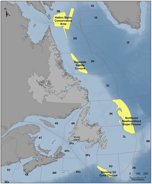
Other Effective Area-based Conservation Measures (OECMs) with coral and sponge conservation objectives in the Canada-Newfoundland and Labrador Offshore Area.
Description
A map showing the land masses of Newfoundland and Labrador, as well as the surrounding Atlantic ocean. Marine refuges are outlined and labeled; from north to south these refuges are:
- Hatton Basin Conservation Area
- Hopedale Saddle Closure
- Northeast Newfoundland Slope Closure
- Division 3O Coral Closure
In December 2022, Canada released an update to the 2016 DFO Marine OECM Guidance that continues to follow the 2016 science advice and reflects 2 important OECM policy developments:
- 2018 United Nations’ Convention on Biological Diversity (CBD) voluntary guidance
- 2019 Government of Canada marine OECM Protection Standard
Visit the updated Marine OECM Guidance. In alignment with the marine OECM Protection Standard and CBD guidance, Canada’s updated OECM guidance requires that existing or foreseeable activities in federal marine OECMs continue to be assessed on a case-by-case basis to ensure that risks to the OECM’s biodiversity conservation benefits have been avoided or mitigated effectively.
An OECM that protects corals and sponges provides biodiversity conservation benefits to the corals and sponges themselves, as well as to diverse populations of other species of fish and invertebrates that utilize the structural habitat that the corals and sponges provide. Potential risks from oil and gas activities to an OECM’s conservation objectives are considered during various regional, environmental and impact assessment processes, and available tools under the Fisheries Act may be used to ensure that any risks are effectively avoided or mitigated. The requirement for a Fisheries Act Authorization will be determined on a site-specific basis, with the application of a risk-based approach to assess the potential for harmful impacts to fish and fish habitat. Implementing this guidance will result in a high level of scrutiny to any proposed activities and their impacts on corals and sponges within OECMs.
1.3 Cold water corals and sponges in Newfoundland and Labrador
Cold water corals and sponges play important roles in marine ecosystems, including:
- biogeochemical cycling of organic matter
- substrate stabilization
- provision of large- and small-scale habitats
Areas of high coral species diversity have been positively correlated with areas of high fish species richness, density, and diversity (Edinger et al., 2007a, 2007b; Jensen & Frederiksen, 1992). These complex three-dimensional structures provide other marine species, including fish species, habitats for:
- feeding
- resting
- spawning
- predator avoidance
- acting as nurseries for juveniles (Baillon et al., 2012; Baker et al., 2012; Buhl-Mortensen & Mortensen, 2005; Buhl-Mortensen et al., 2010).
Coral and sponge species are assigned to functional groups according to body size, shape, habitat (i.e. substrate) preferences, and life history traits (DFO, 2021). The focus of this guidance is on 5 habitat-forming functional groups present in NL including:
- large gorgonians
- small gorgonians
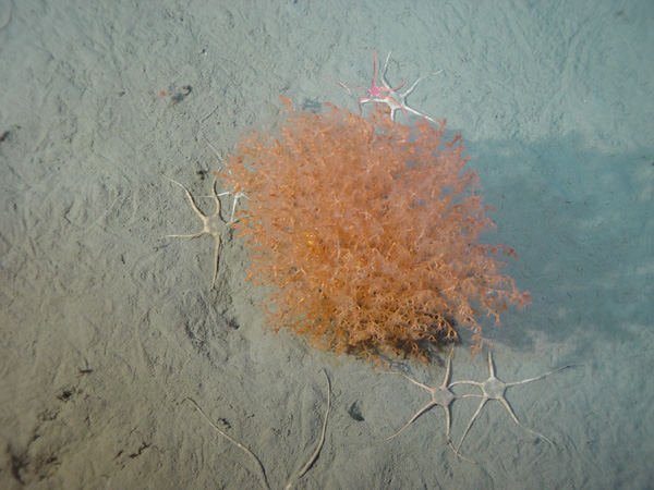
- sea pens
- sponges
- black corals
Substrate type and bottom temperature are the key variables determining distribution of these functional groups, while current speed, slope, surface chlorophyll A concentration, and depth are additional factors influencing distribution (Baker et al., 2012; Bryan & Metaxas, 2006, 2007; Edinger et al., 2011). Preferred depths range from < 100 m to > 2000 m. Corals can be categorized into those typically associated with hard substrates (gorgonians, black corals, stony corals) and those associated with softer (sand and mud) substrates (small gorgonians, sea pens, some soft corals) (Breeze et al., 1997; Edinger et al., 2011; Gass, 2003).
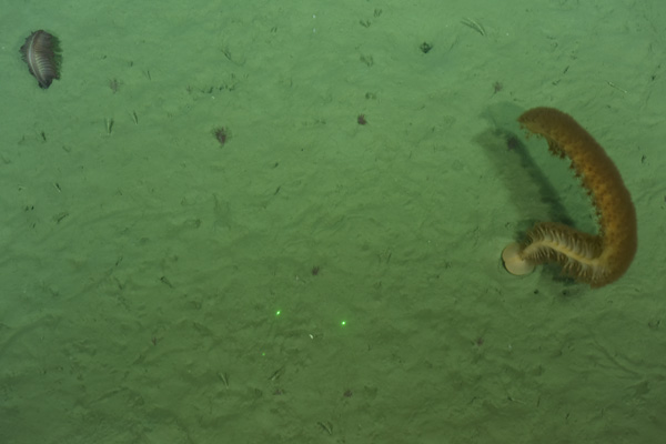
Approximately 70 species of deep-sea corals and 150 species of sponges have been observed across the continental shelf, in troughs, valleys, and canyons, as well as along the shelf edge in the waters off NL (Edinger et al., 2011; Sherwood & Edinger, 2009). Species distributions (in particular concentrations), diversity and abundance studies for NL have been reported in Gilkinson and Edinger (2009), Wareham (2010), and Wareham and Edinger (2007). Research suggests that the Hudson Strait, at the northern tip of Labrador, is the most important coral hotspot in NL, specifically hosting a higher abundance of large gorgonians (Primnoa sp. and Paragorgia sp.) than elsewhere in the region (Edinger et al., 2011). Overall, peak coral diversity and density in the NL region was found from Funk Island Spur to Tobin’s Point and at the mouth of the Hawke Saddle (Edinger et al., 2007a). The highest concentration of sea pens is found in the Laurentian Channel (Kenchington et al., 2016). Modelling results concurred with previous studies that areas of suitable habitat and those with a higher presence of corals and/or sponges are located along the slope of the continental shelf and within canyons on the upper continental shelf (Gullage et al., 2017). Kenchington et al. (2019) identified “significant concentrations” of five Vulnerable Marine Ecosystem (VME) indicator taxa (large-sized sponges, sea pens, black corals, small and large gorgonians) in the NAFO Regulatory Area (NRA) using kernel density estimation (KDE). Sponges represent the highest biomass in the study area. Sea pen fields were identified in low-relief sand and mud habitats, and small and large gorgonians were less prominent in the study area.
Corals and sponges in NL are characterized by great longevity, slow growth rates, and infrequent recruitment and therefore, have recovery rates that take centuries (DFO, 2018; Sherwood & Edinger, 2009). In addition, the structures and sessile nature of corals and sponges make these species vulnerable to disturbance associated with bottom contact industrial activities such as oil and gas development. Corals and sponges are filter feeders, extracting nutrients from the water column, which elevates their susceptibility to risks associated with increased suspended sediments. Sedimentation reduces the ability of corals to feed and in some cases could lead to polyp mortality (Brooke et al., 2009; Gass & Roberts, 2006; Liefmann et al., 2018). Cordes et al. (2016), Fang et al. (2018), and Grant et al. (2019) report on the impacts of sediment resuspension and drill cuttings on coral and sponge communities, with effects that include:
- suffocation
- density and abundance reduction
- reduced oxygen consumption
- reduced release of nitrate and nitrite
Potential impacts of exploration activities on corals and sponges may include:
- removal (mortality)
- dislodgement
- injury
- inhibition of feeding
- other behavioural impacts due to sedimentation
Localized impacts on coral and sponge abundance and richness, as well as hampering of functional roles as habitat to other species are also possible. Chemical toxicity, physical effects on tissues, and habitat destabilization may also occur. The sensitivity of corals and sponges to physical contact varies depending on the functional group. For example, large gorgonians and black corals are at higher risk since they have ridged skeletons and longer lifespans, while smaller, more flexible colonies such as some species of sea pens, sponges, and soft corals are at lower risk of damage and mortality as they have faster growth rates and shorter lifespans (Austin et al., 2007; Edinger et al., 2007a).
1.4 Operational framework for Regulatory Review of exploration activities in Canada-NL Offshore Area
The C-NLOPB issues Operations Authorizations for exploration and development activities in the Canada-NL Offshore Area, with advice from DFO at a number of stages of the regulatory process. Exploratory drilling projects inside an OECM follow the same regulatory review process as those outside, but with the additional requirement of an OECM Plan (refer to section 2.3.4).
As required by the conditions of project-specific EAs and the regulation, the proponent consults with the C-NLOPB and DFO to develop and conduct a Seabed Investigation Survey (refer to section 2.3) prior to the drilling of each well, to determine whether there are any aggregations of habitat-forming corals and/or sponges or any other environmentally sensitive features around each proposed well site. The survey includes transects around each well site with a length and pattern that is based on applicable drill cuttings dispersion model results, as well as transects around each anchor site, if applicable (IAAC, 2020).
If it is determined, based on the Seabed Investigation Survey results, that there are aggregations of habitat-forming corals and/or sponges in the survey area, measures are proposed to avoid affecting them, including relocation of the anchors or wells on the seafloor or redirecting the discharge of drill cuttings. A review of the Seabed Investigation Survey results and supporting data is conducted by the C-NLOPB and DFO.
Following a review of the Seabed Investigation Survey results, DFO may recommend relocation of the well within the drill center survey area (refer to section 2.4.1.1). A number of factors will be considered (including abundance, spatial distribution, and other ecological considerations), and lower risk tolerances will be applied inside OECMs. There is also a provision of real-time well relocation if the proponent encounters high abundances of corals and/or sponges and decides it is technically feasible to move.
Where low abundances and/or spatial distribution of corals and/or sponges are identified, relocation of the well or redirection of drill cuttings may not be required. Where a recommendation is made to relocate or redirect, the proponent will need to determine if these options are technically feasible. If both options are not technically feasible, other mitigation measures will be determined in consultation with DFO and the C-NLOPB (refer to section 2.4.2).
If an exploration project is proposed within an OECM, a separate plan is required. The OECM Plan is developed by the proponent, in consultation with DFO and the C-NLOPB, and provided to DFO and the C-NLOPB at least 90 days before the beginning of the drilling program. DFO will provide advice to the C-NLOPB on the results of its review of the OECM Plan.
The OECM plan includes a description of:
- the potential effects of the activity with respect to the conservation objectives for the area;
- the mitigation measures that are planned to limit the adverse effects of the activity on those objectives;
- the monitoring activities that will be used to determine effectiveness of mitigation measures; and
- the frequency with which updates, concerning implementation of the mitigation measures and the results of monitoring activities, will be provided to DFO and the C-NLOPB (IAAC, 2020).
In addition to the Seabed Investigation Survey, the proponent is required to develop and implement a follow-up and monitoring program (refer to section 2.5) that includes a study of the adverse effects of drill cuttings discharge on benthic habitat, which is conducted in consultation with DFO and the C-NLOPB. This requirement applies to:
- the first well in each exploration licence;
- any well where drilling is undertaken in an area determined by seabed investigation studies to be sensitive benthic habitat;
- any well located within a special area designated as such due to the presence of sensitive coral and sponge species (e.g. OECMs); or
- a location near such a special area where drill cuttings dispersion modelling predicts that the deposition of drill cuttings may have adverse effects on corals and sponges (IAAC, 2020).
Specifically, the proponent is required to:
- measure the post-drilling extent and thickness of the deposition of drill cuttings in order to verify the drill waste deposition modelling predictions;
- conduct benthic fauna studies to determine the effectiveness of mitigation measures; and
- compare the modelling results to in situ results (IAAC, 2020).
The follow-up and monitoring results are to be provided to the C-NLOPB no later than 60 days after the day on which the first well in each exploration licence is completed (refer to section 2.6.2).
2. Operational guidance to avoid or mitigate impacts to corals and sponges during exploration drilling activities
2.1 Context
This guidance outlines measures that should be implemented before, during, and after exploratory drilling in the Canada-NL Offshore Area to minimize impacts on aggregations of habitat-forming corals and sponges. It is not prescriptive, but rather provides transparency on expectations by outlining a process for proponents to meet regulatory and policy requirements, and providing certainty for industry.
The guidance has been developed in response to current regulations and policies relevant to exploratory drilling, including conditions of project-specific EAs, the regulation, and the Government of Canada’s 2022 Marine OECM Guidance. It does not replace established EA conditions or other regulatory requirements. It will inform provision of advice and recommendations by DFO to the C-NLOPB concerning mitigations to minimize impacts to corals and sponges. It is also to be used by proponents in designing and planning exploratory drilling projects or programs.
The guidance considers:
- best available scientific information and advice
- international standards
- regional industry practices
- feedback from interested parties
It takes a balanced approach to maintain high levels of environmental protection during exploratory drilling programs. DFO will continue to use a scientific, risk-based approach to assess industrial activities such as petroleum exploration on a case-by-case basis. The guidance will be updated in response to new science, regional experience, and advancement of best practices.
2.2 Definitions
- Aggregation of habitat-forming corals or sponges:
- An aggregation of corals or sponges that are known or observed to support fish (IAAC, 2021).
- Before-after-control-impact (BACI):
- This method involves an impacted site, a control site with comparable characteristics, as well as impact and temporal factors. Data must be available for pre- and post-impact. Having a control site factors in the natural changes that occurred over time, which allows the effects of the impact to be determined (Seger et al., 2021).
- Coral and sponge functional groups:
- Coral and sponge species are divided into functional groups based on general morphologies, habitat preferences and/or life history traits (DFO, 2021). They include habitat-forming:
- large gorgonians
- small gorgonians
- sea pens
- sponges
- black corals
- other corals (e.g. soft corals, cup corals, hydrocorals)
Individual functional group definitions can be found in Annex A.
- Directional drilling:
- This type of drilling is used when target petroleum formations are inaccessible solely by vertical drilling. Directional drilling involves vertical drilling and horizontal drilling; wells are drilled vertically into the earth and then the well is bent at the target depth to drill horizontally through the petroleum formation. To accomplish this type of drilling, a flexible drilling pipe with a steerable drill bit is used (CAPP, 2021).
- Drill cuttings:
- Drilling solids or cuttings are particles that are generated by drilling into subsurface geological formations and are carried to the surface with drilling muds (C-NLOPB, 2010).
- Drill cuttings dispersion model:
- A model of the predicted area around the drill site that will be subject to impact by drill cuttings during exploratory drilling, which predicts the distance and thickness of the dispersed cuttings. The spatial boundary defined by the drill cuttings dispersion model is also known as the zone of influence for project contaminants, outside of which no effects of drill cuttings are expected (DFO, 2021).
- Drilling muds:
- Drilling muds lubricate the drill bit, regulate pressure and temperature, and transport cuttings to the surface, during drilling (CAPP, 2017). Drilling muds can be:
- oil-based (OBM)
- water-based (WBM)
- synthetic-based (SBM)
Exploratory drilling in Atlantic Canada uses WBM or SBM as they are of lower toxicity (Buchanan et al., 2003); OBMs can only be used when sufficient technical justification is provided (AMEC, 2014; C-NLOPB, 2019).
- Other Effective Area-Based Conservation Measure (OECM):
- A geographically defined area other than a protected area, which is governed and managed in ways that achieve positive and sustained long-term outcomes for the in situ conservation of biodiversity with associated ecosystem functions and services and, where applicable:
- cultural
- spiritual
- socioeconomic
- other locally relevant values (CBD, 2018).
- Predicted/probable no-effects threshold (PNET):
- Drill cuttings dispersion modelling predicts the area where drill cuttings of various thickness will attain PNET. The threshold beyond which benthic species are subject to the adverse effects of burial is the 6.5 mm sediment thickness PNET. A more conservative threshold that pertains to sensitive benthic species such as corals and sponges is the 1.5 mm sediment thickness PNET (Kjeilen-Eilertsen et al., 2004; Smit et al., 2006, 2008).
- Pre-drill survey:
- Pre-drill surveys establish baseline conditions of the area around the drill site, determining the presence of corals and sponges. Results of the pre-drill survey are used in the decision to relocate wells or anchors, redirect drill cuttings, or implement other mitigations during drilling (DFO, 2021). These surveys are also used to compare to the results of follow-up and monitoring.
- Qualified individual:
- An individual who has the necessary education, experience and knowledge to conduct studies and provide advice in a particular field, and includes a person with community knowledge or Indigenous knowledge (IAAC, 2020). In the scope of this work, the particular fields of interest are marine benthic ecology and visual surveys.
- Significant Benthic Areas (SiBA):
- Areas that are dominated by cold-water corals and sponges. Factors that contribute to significance include knowledge of the species, communities, and ecosystems associated with the area (DFO, 2013).
- Vulnerable Marine Ecosystem Indicator species:
- Species that signal the occurrence of a Vulnerable Marine Ecosystem (NAFO, 2015).
- Vulnerable Marine Ecosystems (VME):
- Marine ecosystems considered vulnerable on the basis of the:
- uniqueness or rarity
- functional significance
- structural complexity
- fragility
- life-history traits
of component species that make recovery difficult (FAO, 2009).
2.3 Pre-drill Seabed Investigation Survey
The pre-drill coral and sponge survey, also referred to as the Seabed Investigation Survey, is a requirement (IAAC, 2020), and will be developed and conducted in consultation with DFO and the C-NLOPB prior to the drilling of each well. The survey will establish baseline data for coral and sponge abundance, density, condition, and distribution of functional groups. The survey design will be repeated during follow-up and monitoring, if required, in order to establish a before-after-control-impact (BACI) design.
2.3.1 Visual Seabed Investigation Survey data collection and analysis
The visual Seabed Investigation Survey should be conducted by a qualified individual and produce data that is of sufficient quality and quantity to identify corals and sponges to the functional group level (Annex A). It is also important that imagery data is comparable, both in terms of survey coverage and quality of the data, between the pre-drill survey and follow-up and monitoring programs. Recommendations for visual survey data collection and analysis are as follows:
- Visual survey data will be collected along entire transects.
- Video altitude of 1-2 m, maximum vessel speed of 0.5 knots, video resolution of 0.3 m (DFO, 2021).
- Scaling lasers will be used.
- Data will be collected on abundance, density, spatial distribution and condition of corals and sponges encountered to the functional group taxonomic level.
- Visual survey data will be accompanied by a log report. The log report will outline details including; time stamp, accurate start and end positions of each transect, ship position in relation to ROV/AUV, observations on encountered technical difficulties, equipment specifications, etc. (Annex B).
- All video and associated log reports will be provided to DFO (Annex B).
- Data should be represented on a scaled schematic, outlining distribution and abundance of coral and sponge functional groups.
Coral condition: The degree of impact on corals and sponges from smothering is outlined in the DNV handbook as a low impact from sediment deposition of 1-3 mm, a moderate impact from 3-10 mm and a significant impact from >10 mm, which is in line with the conservative 1.5 mm PNET used for sensitive species in drill cuttings dispersion models and survey programs (DFO, 2021; DNV, 2019). Although coral health is a new area of research, there are elements of coral condition that can be used as a proxy for health of coral and sponge colonies, in order to examine impacts on corals and sponges and verify effectiveness of mitigation measures implemented. Annex C, Table C2 outlines various indicators that proponents can look for and provides reference photos (Figures C1-C5) of damaged and dead corals. The coral and sponge data collection template (Annex C, Table C1) should be filled out for all corals and sponges in the drill center survey area, drill cuttings dispersion model area and the two reference sites covered during the Seabed Investigation Survey and during follow-up and monitoring.
2.3.2 Guidance on visual Seabed Investigation Survey design
The pre-drill coral and sponge benthic survey design (Figure 2) includes:
- a drill center survey area based on the extent of the 6.5 mm PNET and associated transects,
- survey buffer,
- radial transects,
- drill cuttings dispersion area based on the extent of the 1.5 mm PNET and associated model transects,
- guardrails and reference sites.
Alternate survey designs will be considered provided sufficient coverage and inclusion of necessary components.
The drill center survey area will be a minimum of 200 m x 200 m (Figures 2 and 3) around the well site, but may be larger as determined by the extent of the 6.5 mm PNET.
- Drill center survey area transects will be parallel to each other, and perpendicular to the midline of the drill cuttings dispersion model area.
- Parallel transects will be spaced 25 m apart, with additional transects inside the survey buffer, if applicable.
Deviations may be accepted if environmental conditions render the planned design unsuitable. However, transect coverage should be maintained. Radial transects will extend out radially from the proposed well location (Figures 2 and 3).
- Radial transect length will be determined by the extent of the dispersion model using the 1.5 mm PNET plus a 10% guardrail on the end of each transect.
- Outside OECMs, 8 radial transects at 45° angles will extend from the proposed well location (Figure 2).
- Inside OECMs, 16 radial transects will extend from the proposed well location (Figure 3). Eight pairs of radial transects with 10° angles in between will fan out from the well location. The angle between each of the 8 pairs will be at 35°.
Model transects will extend over the drill cuttings dispersion model area (predicted zone of influence) identified by the precautionary 1.5 mm PNET for sensitive species (Figures 2 and 3).
- Model transects will be equal to the length of the widest portion of the drill cuttings dispersion model area plus a 10% guardrail added to both sides of each transect.
- Model transects will be parallel to each other, and perpendicular to the midline of the drill cuttings dispersion model area.
- Model transects will extend out from the drill center survey area at increasing intervals (e.g. 50 m, 100 m, 200 m, etc.) to the extent of the 1.5 mm PNET.
- One additional transect beyond the extent of the 1.5 mm PNET can be used as a reference site (Figures 2 and 3).
Survey extension guardrails of 10% are added to the end of each radial transect and both ends of the modelled transects to account for uncertainty and to inform follow-up and monitoring.
Reference sites will be identified outside of the expected zone of influence to determine levels of environmental change relative to baseline conditions. The reference sites are used to assess natural variability and should include the following:
- A minimum of 2 reference sites should be surveyed outside of the predicted drill cuttings dispersion model area (one upstream and one downstream).
- The upstream reference site will depend on modeling and proposed survey design.
- The downstream transect, beyond the extent of the 1.5 mm PNET, can be used as a reference site (Figures 2 and 3).
- Reference sites should have similar background conditions (depth, seabed type, slope, temp, etc.) as the survey transects.
- Repeat the same visual survey methods as conducted along survey transects.
- If sediment collection is undertaken, duplicate samples at each reference site are recommended.
If anchors are to be used during exploration drilling, transects around each anchor that extend at least 50 m from each structure should be visually surveyed in a cross hair pattern with 4 radials evenly spaced apart and extending out from each anchor.
Survey buffers of 100 m will be added around the 200 m x 200 m drill center survey area (Figures 2 and 3). If the drill center survey area is larger than 200 m x 200 m based on the extent of the 6.5 mm PNET, the size of the survey buffer will be increased accordingly. For example, if the drill center survey area is 300 m x 300 m based on the extent of 6.5 mm PNET, then the survey buffer would be 150 m. The survey buffer will accommodate well relocation within the drill center survey area, if recommended by DFO following review of the Seabed Investigation Survey results (refer to section 2.4.1.1). If the proponent makes a real-time decision to relocate the well site, then the survey should be conducted centered on the new well location and a survey buffer is not required.
2.3.3 Additional OECM recommendations before drilling
Additional recommendations include:
- if technically feasible, one sample of the dominant species for each of the functional groups that are prevalent throughout the survey should be collected during the pre-drill survey or in the immediate vicinity of the proposed wellhead just prior to drilling, with the exception of black corals; and
- close-up still photos should be taken during the pre-drill survey or in the immediate vicinity of the proposed wellhead just prior to drilling.
- photos of the entire colony, with scale bars or lasers, should be taken in addition to these close-up photos of key features (e.g. polyps, attachment to substrate).
2.3.4 OECM plan
If exploration drilling is conducted inside an OECM, the OECM Plan must be submitted to DFO and the C-NLOPB at least 90 days before the beginning of the drilling program, and include a description of:
- the potential effects of the activity with respect to the conservation objectives for the area.
- the potential direct and indirect impacts on corals and sponges, including:
- spatial footprint of the well
- predicted drill cuttings dispersion model area;
- the mitigation measures that will be implemented to limit the adverse effects of the activity on corals and sponges, in consultation with the C-NLOPB and DFO;
- the monitoring activities that will be used to measure effectiveness of mitigations taken, including:
- changes to abundance and condition of corals and sponges
- confirmation of the extent and thickness of drill cuttings
- monitoring will follow survey design specifications outlined for OECMs for the pre-drill survey to ensure they are comparable (spatial coverage and data quality). Description of methods and equipment being used will be included; and
- the frequency at which updates with respect to the implementation of the mitigation measures and the results of monitoring activities will be provided to DFO and the C-NLOPB.
An OECM Plan Template is provided in Annex D.

Pre-drill seabed investigation survey design – outside OECMs. For illustrative purposes only; survey extent, radial length etc. will be based on project specific modeling.
Description
The drill centre is surrounded by a box representing the drill centre survey area, in which drill cuttings are expected to accumulate to a thickness of at least 6.5 mm. This box is nested within a larger box representing the seabed survey buffer. There are also 8 radial transects originating at the drill centre and fanning out like spokes on a wheel. These transects are spaced 45 degrees apart from one another. South of the drill centre is a dark plume representing the area in which drill cuttings will accumulate to a thickness of at least 1.5 mm, as predicted by the drill cuttings dispersion model results. Running perpendicular to the model plume are 10 model survey transects which span the full width of the model plume and are capped on each end by additional guardrails. The model survey transect furthest from the drill centre is located just outside the model plume and is labeled as a potential reference site.

Pre-drill seabed investigation survey design – inside OECMs. For illustrative purposes only; survey extent, radial length etc. will be based on project specific modeling.
Description
The drill centre is surrounded by a box representing the drill centre survey area, in which drill cuttings are expected to accumulate to a thickness of at least 6.5 mm. This box is nested within a larger box representing the seabed survey buffer. There are 16 radial transects originating at the drill centre and fanning out like spokes on a wheel. These transects are drawn in pairs spaced 10 degrees apart from one another, with 35 degrees between each pair. A highlighted box at the top of the schematic indicates that this is twice the number of radial transects, compared to the survey design for outside of OECMs. South of the drill centre is a dark plume representing the area in which drill cuttings will accumulate to a thickness of at least 1.5 mm, as predicted by the drill cuttings dispersion model results. Running perpendicular to the model plume are 10 model survey transects which span the full width of the model plume and are capped
2.4 Avoidance protocols and mitigation options for exploration drilling in areas of aggregations of habitat-forming corals and sponges
Corals and sponges are likely to be found in the Canada-NL offshore. As such, measures will be taken to avoid and/or minimize mortality, injury and other effects. This guidance considers mitigation options in international (BSI, 2012; DNV, 2013) and regional practices, including those in project-specific EA processes and from regional science advice (DFO, 2021). Coral and sponge protection measures will take into account the local environment and conditions, and will align with international best practices. Mitigations inside OECMs versus outside will likely be different, with more stringent protections inside (refer to sections 2.3.3, 2.4.3, 2.5.2).
2.4.1 Avoidance protocols
As outlined in project-specific EAs and the regulation if a competent person (as defined by IAAC, 2020) concludes, on the basis of the seabed investigation study, that there are aggregations of habitat-forming corals or sponges or other environmentally sensitive features in the activity area, measures are taken to avoid affecting them, including moving the anchors or wells on the seafloor or redirecting the discharge of drill cuttings (IAAC, 2020).
The 2 options for avoidance are:
- relocation of wells or anchors on the sea floor; or
- redirection of the discharge of drill cuttings.
2.4.1.1 Relocation
The decision to relocate a well can either be made in real-time by the proponent during the Seabed Investigation Survey or following an assessment of seabed survey results. The proponent can also survey an alternate well location during the seabed investigation survey. The following will be considered in any decision to relocate wells or anchors on the sea floor:
- technical feasibility, including factors such as:
- harsh deep water environments
- health and safety
- etc.
- however, if relocation is not technically feasible, rationale should be provided;
- operational considerations for movement of well site within the drill center survey area (determined by the 6.5 mm PNET or minimum 200 m x 200 m) or where the proponent chooses to move a well location in real-time during the seabed investigation survey. Information used in this real-time decision should be provided to the C-NLOPB and DFO; and
- presence of aggregations of habitat-forming corals and/or sponges found during the seabed investigation survey.
Well relocation (either in real-time or during assessment of seabed survey results) to avoid or reduce impacts on corals and sponges within the drill center survey area will be based upon an assessment of each site that will include:
- abundance and spatial distribution of 5 functional groups (black corals, large gorgonians, small gorgonians, sea pens, and sponges – refer to section 1.3);
- vulnerability of functional groups;
- black corals are rare on continental shelf with a longer life span and rigid fragile skeleton;
- large gorgonians with longer life spans and rigid fragile skeletons;
- overlapping functional groups (areas with greater than one functional group provide benefit to more than one benthic community); and
- footprint of the well and associated modelling (i.e. smothering as a result of drill cuttings).
Approach taken should focus on abundance and spatial distribution inside the drill center survey area, with consideration of the above listed factors in identifying the site with least impacts to corals and sponges.
2.4.1.2 Redirection
In areas with aggregations of habitat-forming corals and/or sponges as determined by the seabed investigation survey, measures to redirect the discharge of drill cuttings should be taken, where technically feasible. This may involve the redirection of drill cuttings to a specified discharge point on the sea floor away from the well. An example of a method of redirection is subsea cuttings transport systems (CTS), where drill cuttings and fluids are collected from the wellhead and transported to a discharge location. CTS has been identified as the preferred technology based on an evaluation of:
- reliability
- complexity
- environment
- cost-benefit from other similar areas in the world (DNV, 2013).
2.4.2 Other mitigations
As outlined in project-specific EAs and the regulation if such movement or redirection is not technically feasible, other mitigation measures determined in consultation with the Department of Fisheries and Oceans and the Board are taken (IAAC, 2020).
Other mitigations can include but are not limited to:
- use of seabed pump to return drill cuttings and fluids to the drilling rig:
- Riserless Mud Recovery (RMR) systems enable the separation of drill cuttings and fluids on the drilling rig (DNV, 2013), followed by a method of disposal:
- untreated discharge: collected water-based drill cuttings are separated with a shaker and discharged from the drilling rig at the surface (DNV, 2013);
- coarse slurrification and discharge: drill cuttings are ground to finer particles, mixed with water, and discharged from the drilling rig at the surface (DNV, 2013);
- slurrification and reuse as spud mud: drill cuttings are processed by grinding to finer particles, and mixed with water and chemicals to meet specifications of drilling fluid (DNV, 2013); or
- coarse slurrification of separated cuttings for disposal at the sea floor: consists of a combination of CTS and mud recovery techniques (DNV, 2013).
As technology advances, new/innovative mitigation measures will also be considered.
2.4.3 Enhanced OECM avoidance and mitigation options
There will be an elevated expectation to demonstrate avoidance or mitigation of impacts to corals and sponges in OECMs which will be considered in decisions regarding relocation, redirection, or other mitigations. If technically feasible, an additional mitigation option that can be implemented inside OECMs is directional drilling. This type of drilling, as described in section 2.2, is typically used when target oil and gas reserves are inaccessible solely by vertical drilling, but can be used as a measure to avoid aggregations of corals and sponges.
2.5 Follow-up and monitoring
Follow-up and monitoring is informed by the pre-drill Seabed Investigation Survey results and the drill cuttings dispersion model. The follow-up and monitoring plan will be submitted to the C-NLOPB and reviewed by C-NLOPB and DFO.
Follow-up and monitoring is required at the first well in each exploration licence, at any well where aggregations of habitat-forming corals and/or sponges have been identified during the seabed investigation survey, and at any well located within or adjacent to a special area designated as such based on benthic conservation objectives (e.g. OECMs).
The follow-up and monitoring program is used to verify:
- predictions of environmental effects, specifically impacts to corals and sponges;
- effectiveness of mitigation measures; and
- accuracy of drill cuttings dispersion model results.
2.5.1 Follow-up and monitoring survey design
The follow-up and monitoring survey will follow the same design as the pre-drill survey, and include the following:
- measurement of the extent of drill cuttings, looking for changes in color or other visual cues. Visual surveys may be used in combination with other methods, such as sediment collection and analysis;
- measurement of thickness of drill cuttings;
- figure of spatial distribution of corals and sponges (post-drilling);
- comparison of abundance, density, and condition of corals and sponges to pre-drill survey results to verify effectiveness of mitigation measures. A coral and sponge data collection template is provided in Table C1, Annex C;
- collection of imagery along entire transects. If no corals are identified outside the drill cuttings dispersion model area, then follow-up and monitoring will focus on the drill center survey area, modelled transects and reference sites; and
- assessment of the deposition of drill cuttings and muds on corals and sponges to verify the drill cuttings dispersion model.
One method of measuring the extent of drill cuttings is sediment analysis. Sediment collection and analysis is recommended inside OECMs and outside OECMs if aggregations of habitat-forming corals and/or sponges have been identified during the seabed investigation survey. If sediment collection is chosen, recommendations for sediment collection and analysis are as follows:
- sediment analysis may include measurement of the weighing agent, such as barium. Barium has been shown to be a valuable parameter for measuring dispersion of drill cuttings (DNV, 2013). It can be used in combination with the visual survey to indicate the extent of drill cuttings; a comparison of before and after drilling should occur as part of the follow-up monitoring.
- sufficient sediment sampling coverage with duplicate samples at each station
- in the 4 main compass directions of the drill center survey area;
- in the drill cuttings dispersion model area at increasing intervals away from the drill center, with sampling stations at the center and ends of a subset of the modelled transects; and
- at the reference sites.
2.5.2 Additional OECM follow-up and monitoring recommendations
Follow-up and monitoring inside OECMs is required for every well on the exploration licence. It includes all measures required outside OECMs, and should be enhanced as follows:
- survey design with greater spatial coverage including higher number of radial transects (16) and a modified cloverleaf survey pattern (Figure 3); and
- close-up still photos in the immediate area around the wellhead once drilling is complete. Photos of the entire colony, with scale bars or lasers, should be taken in addition to these close-up photos of key features (e.g. polyps, attachment to substrate).
2.6 Reporting
Reporting is important to ensure impacts to corals and sponges are avoided or mitigated effectively in exploration drilling programs in NL. The pre-drill Seabed Investigation Survey plan and report, the follow-up and monitoring plan and report, and the OECM Plan are requirements. Recommendations on details of what is to be included in each plan/report are also included below. The following section outlines reporting in chronological order for all data, results and plans associated with exploration drilling programs. The technical specifications for all equipment used during the Seabed Investigation Survey and follow-up and monitoring should be described. All data should be collected and analyzed in a standardized and reproducible way. A data log (Annex B) should accompany the photo and video data provided to DFO and the C-NLOPB.
2.6.1 Pre-drilling reporting
The pre-drill Seabed Investigation Survey plan will be submitted to the C-NLOPB and also reviewed by DFO. It should include, at a minimum, the following:
- figure depicting survey design pattern with drill cuttings dispersion model indicating 1.5 mm and 6.5 mm PNET; and
- description of survey methodology and equipment to a level of detail such that survey is fully reproducible.
The Seabed Investigation Survey results will be submitted to the C-NLOPB and also reviewed by DFO. The results should include, at a minimum, the following:
- figure of spatial distribution of corals and sponges over survey area;
- summary of abundance and density of corals and sponges before drilling;
- coral and sponge condition data collection template (Annex C, Table C1) and a summary of the percentage of damaged or dead corals and sponges;
- summary of real-time decision to relocate with supporting data, if applicable;
- proposed mitigation measures to be implemented;
- photos, videos, and data log (Annex B);
- list of all equipment used during the survey and associated specifications; and
- specimen collection with associated locational data, if applicable.
The OECM Plan (Annex D), if applicable, will be submitted to DFO and the C-NLOPB at least 90 days before the beginning of the drilling program. The plan provides a description of the frequency at which updates with respect to the implementation of the mitigation measures and the results of monitoring activities will be provided to DFO and the C-NLOPB.
The follow-up and monitoring plan will be submitted to the C-NLOPB and also reviewed by DFO. It should clearly articulate the plan for:
- measuring post-drilling extent and thickness of the deposition of drill cuttings in order to verify the drill cuttings dispersion modelling predictions;
- conducting benthic fauna studies to verify the effectiveness of mitigation measures; and
- comparing the modelling results to in situ results.
2.6.2 Post-drilling reporting
Follow-up and monitoring results must be submitted to the C-NLOPB no later than 60 days after drilling is complete, and will be reviewed by DFO. The results should address how the requirements above were met and include, at a minimum, the following:
- figure of spatial distribution of corals and sponges over survey area;
- summary of abundance and density of corals and sponges after drilling;
- coral and sponge data collection template (Annex C, Table C1) and a summary of the percentage of damaged or dead corals and sponges;
- drill cuttings extent and thickness;
- sediment analysis results, if applicable;
- photos, video and data log (Annex B); and
- list of all equipment used during the survey and associated specifications.
References
- AMEC. (2014). Eastern Newfoundland strategic environmental assessment. Canada-Newfoundland and Labrador Offshore Petroleum Board. https://www.cnlopb.ca/wp-content/uploads/enlsea/ch1-3.pdf
- Austin, W.C., Conway, K.W., Barrie, J.V., & Krautter, M. (2007). Growth and morphology of reef-forming glass sponge, Aphrocallistes vastus (Hexactinellida), and implications for recovery from widespread trawl damage. Custodia, M.R., Lobo-Hajdu, G., Hajdu, E., Muricy, G., (Eds.), Porifera research: Biodiversity, innovation and sustainability. Universidade Federal do Rio de Janeiro. https://www.researchgate.net/profile/Marcio-Custodio-2/publication/257954142_Porifera_Research_Biodiversity_Innovation_and_Sustainability/ links/0deec526798bb07302000000/Porifera-Research-Biodiversity-Innovation-and-Sustainability.pdf
- Baillon, S., Hamel, JF., Wareham, V.E., & Mercier, A. (2012). Deep cold-water corals as nurseries for fish larvae. Frontiers in Ecology and the Environment, 10(7), 351-356. https://doi.org/10.1890/120022
- Baker, K.D., Wareham, V.E., Snelgrove, P.V.R., Haedrich, R.L., Fifield, D.A., Edinger, E.N., & Gilkinson, K.D. (2012). Distributional patterns of deep-sea coral assemblages in three submarine canyons off Newfoundland, Canada. Marine Ecology Progress Series, 445, 235–249. https://doi.org/10.3354/meps09448
- Breeze, H., Butler, M., & Davis, D. S. (1997). Distribution and status of deep sea corals off Nova Scotia. Marine Issues Committee, Ecology Action Centre.
- Brooke, S. D., Holmes, M. W., & Young, C. M. (2009). Sediment tolerance of two different morphotypes of the deep-sea coral Lophelia pertusa from the Gulf of Mexico. Marine Ecology Progress Series, 390, 137-144. https://doi. org/10.3354/meps08191
- Bryan, T. L., & Metaxas, A. (2006). Distribution of deep-water corals along the North American continental margins: Relationships with environmental factors. Deep Sea Research Part I: Oceanographic Research Papers, 53(12), 1865– 1879. https://doi.org/10.1016/j.dsr.2006.09.006
- Bryan, T., & Metaxas, A. (2007). Predicting suitable habitat for deep-water gorgonian corals on the Atlantic and Pacific continental margins of North America. Marine Ecology Progress Series, 330, 113–126. https://doi.org/10.3354/ meps330113
- BSI. (2012). Water quality – visual seabed surveys using remotely operated and/or towed observation gear for collection of environmental data. BS EN 16260:2012.
- Buchanan, R.A., Cook, J.A. & Mathieu, A. (2003). Environmental effects monitoring for exploration drilling: Environmental studies research fund – 018. LGL Limited. https://www.esrfunds.org/sites/www.esrfunds.org/files/publications/ ESRF146-BuchananCookMathieu.pdf
- Buhl-Mortensen, L., & Mortensen, P.B. (2004). Gorgonophilus canadensis n. gen., n. sp. (Copepoda: Lamippidae), a gall forming endoparasite in the octocoral Paragorgia arborea (L., 1758) from the northwest Atlantic. Symbiosis, 37, 155– 168. https://dalspace.library.dal.ca/bitstream/handle/10222/78030/VOLUME%2037-NUMBERS%201-3-2004-PAGE%20155.pdf?sequence=1
- Buhl-Mortensen L., & Mortensen P.B. (2005). Distribution and diversity of species associated with deep-sea gorgonian corals off Atlantic Canada. Freiwald A., Roberts J.M., (Eds.), Cold-water corals and ecosystems. Erlangen earth conference series. Springer-Verlag Berlin Heidelberg. https://doi. org/10.1007/3-540-27673-4_44
- Buhl-Mortensen, L., Serigstad, B., Buhl-Mortensen, P., Olsen, M. N., Ostrowski, M., Błażewicz-Paszkowycz, M., & Appoh, E. (2017). First observations of the structure and megafaunal community of a large Lophelia reef on the Ghanaian shelf (the Gulf of Guinea). Deep Sea Research Part II: Topical Studies in Oceanography, 137, 148-156. https://doi.org/10.1016/j.dsr2.2016.06.007
- Buhl-Mortensen, L., Vanreusel, A., Gooday, A. J., Levin, L. A., Priede, I. G., Buhl-Mortensen, P., Gheerardyn, H., King, N.J., & Raes, M. (2010). Biological structures as a source of habitat heterogeneity and biodiversity on the deep ocean margins. Marine Ecology, 31(1), 21-50. https://doi. org/10.1111/j.1439-0485.2010.00359.x
- CAPP. (2017). Exploration drilling in Atlantic Canada offshore. https://www. capp.ca/publications-and-statistics/publications/309260
- CAPP. (2021). Natural Gas Extraction. CAPP: A Unified Voice for Canada’s Upstream Oil and Gas Industry. https://www.capp.ca/natural-gas/ drilling-and-fracturing/
- Carreiro-Silva, M., Braga-Henriques, A., Sampaio, I., de Matos, V., Porteiro, F. M., & Ocaña, O. (2011). Isozoanthus primnoidus, a new species of zoanthid (Cnidaria: Zoantharia) associated with the gorgonian Callogorgia verticillata (Cnidaria: Alcyonacea). ICES Journal of Marine Science, 68(2), 408-415.https:// doi.org/10.1093/icesjms/fsq073
- Convention on Biological Diversity (CBD). (2018). Voluntary guidance on the integration of protected areas and other effective area-based conservation measures into wider land- and seascapes and mainstreaming across sectors to contribute, inter alia, to the Sustainable Development Goals. https://www.cbd. int/doc/decisions/cop-14/cop-14-dec-08-en.pdf
- C-NLOPB. (2010). Offshore Waste Treatment Guidelines. https://www.cnlopb. ca/wp-content/uploads/guidelines/owtg1012e.pdf
- Cochrane, S. K. J., Ekehaug, S., Pettersen, R., Refit, E. C., Hansen, I. M., Aas, L. M. S. (2019). Detection of deposited drill cuttings on the sea floor-A comparison between underwater hyperspectral imagery and the human eye. Marine Pollution Bulletin, 145, 67-80. https://doi.org/10.1016/j.marpolbul.2019.04.031
- Cordes, E.E., Jones, D.O.B., Schlacher, T.A., Amon, D.J., Bernadino, A.F., Brooke, S., Carney, R., DeLeo, D.M., Dunlop, K.M., Escobar-Briones, E.G., Gates, A.R., Génio, L., Gobin, J., Henry, L.A., Herrera, S., Hoyt, S., Joye, M., Kark, S., Mestre, N.C., … Witte, U. (2016). Environmental impacts of the deep-water oil and gas industry: A review to guide management strategies. Frontiers in Environmental Science, 4, 58. https://doi.org/10.3389/ fenvs.2016.00058
- DFO. (2013). Ecological risk assessment framework (ERAF) for coldwater corals and sponge dominated communities. Sustainable Fisheries Framework (SFF): Policy to Manage the Impacts of Fishing on Sensitive Benthic Areas. https:// waves-vagues.dfo-mpo.gc.ca/library-bibliotheque/40585347.pdf
- DFO. (2016). Guidance on identifying “Other Effective Area-Based Conservation Measures” in Canadian coastal and marine waters. Canadian Science Advisory Secretariat. Science Advisory Report 2016/002. http://www.dfo-mpo.gc.ca/ csas-sccs/Publications/SAR-AS/2016/2016_002-eng.html
- DFO. (2018). Framework to support decisions on authorizing scientific surveys with bottom-contacting gears in protected areas with defined benthic conservation objectives. Canadian Science Advisory Secretariat. Science Advisory Report 2018/043. https://waves-vagues.dfo-mpo.gc.ca/library-bibliotheque/40726277.pdf
- DFO. (2021). Coral and sponge mitigations in relation to exploratory drilling programs in the Newfoundland and Labrador region. Canadian Science Advisory Secretariat. Science Advisory Report 2021/028. https://waves-vagues. dfo-mpo.gc.ca/Library/4098834x.pdf
- DNV. (2013). Guideline: Monitoring of drilling activities in areas with presence of cold water corals. Norwegian Oil and Gas Association. https://offshorenorge.no/contentassets/13d5d06ec9464156b2272551f0740db0/ handbook-shec-mapping-assessment-and-monitoring-v0-final-signed.pdf
- DNV. (2019). Species and habitats of environmental concern: Mapping, risk assessment, mitigation and monitoring – in relation to oil and gas activities. Norwegian Oil and Gas Association. https://offshorenorge.no/contentassets/13d5d06ec9464156b2272551f0740db0/handbook-shec-mapping-assessment-and-monitoring-v0-final-signed.pdf
- Edinger, E., Baker, K., Devillers, R., & Wareham, V. (2007a). Coldwater corals off Newfoundland and Labrador: Distribution and fisheries impacts. WWF. https://wwfeu.awsassets.panda.org/downloads/wwf_coral_report_final.pdf
- Edinger, E. N., Wareham, V. E., Simms, A., & Haedrich, R. L. (2007b). Patterns of groundfish diversity and abundance in relation to deep-sea coral distributions in Newfoundland and Labrador waters. Bulletin of Marine Science, 81(3), 101-22. https://www.ingentaconnect.com/content/umrsmas/ bullmar/2007/00000081/a00103s1/art00011
- Edinger, E., & O. Sherwood. (2009). Taphonomy of gorgonian and antipatharian corals in Atlantic Canada: Experimental decay rates and field observations.
- Gilkinson, K., & Edinger, E., (Eds.), The ecology of deep-sea corals of Newfoundland and Labrador waters: biogeography, life history, biogeochemistry, and relation to fishes. Canadian Technical Report of Fisheries and Aquatic Sciences No. 2830. https://www.researchgate.net/profile/Vonda-Wareham-Hayes/publication/236952962_Updated_on_deep-sea_coral_distributions_in_the_Newfoundland_Labrador_and_Arctic_regions_Northwest_Atlantic/ links/54c0f5fb0cf28a6324a4b420/Updated-on-deep-sea-coral-distributions-in-the-Newfoundland-Labrador-and-Arctic-regions-Northwest-Atlantic. pdf#page=94
- Edinger, E. N., Sherwood, O. A., Piper, D. J. W., Wareham, V. E., Baker, K. D., Gilkinson, K. D., & Scott, D. B. (2011). Geological features supporting deep-sea coral habitat in Atlantic Canada. Continental Shelf Research, 31(2), S69–S84. https://doi.org/10.1016/j.csr.2010.07.004
- Fang, J.K.H., Rooks, C.A., Krogness, C.M., Kutti, T., Hoffmann, F. & Bannister,
- R.J. (2018). Impact of particulate sediment, bentonite and barite (oil-drilling waste) on net fluxes of oxygen and nitrogen in Arctic-boreal sponges. Environmental Pollution, 238, 948-958. https://doi.org/10.1016/j.envpol.2017.11.092
- FAO. (2009). International guidelines for the management of deep-sea fisheries in the high seas. https://www.fao.org/3/i0816t/I0816T.pdf
- Gass, S. (2003). Conservation of deep-sea corals in Atlantic Canada. WWF.
- Gass, S.E. & Roberts, J.M. (2006). The occurrence of the cold-water coral Lophelia pertusa (Scleractinia) on oil and gas platforms in the North Sea: Colony growth, recruitment and environmental controls on distribution. Marine Pollution Bulletin, 52(5), 549-559. https://doi.org/10.1016/j. marpolbul.2005.10.002
- Gates, A. R., Benfield, M. C., Booth, D. J., Fowler, A. M., Skropeta, D., & Jones, D. O. (2017). Deep-sea observations at hydrocarbon drilling locations: contributions from the SERPENT Project after 120 field visits. Deep Sea Research Part II: Topical Studies in Oceanography, 137, 463-479. https://doi. org/10.1016/j.dsr2.2016.07.011
- Gilkinson, K., & Edinger, E. (Eds.). (2009). The ecology of deep-sea corals of Newfoundland and Labrador waters: biogeography, life history, biogeochemistry, and relation to fishes. Canadian Technical Report of Fisheries and Aquatic Sciences No. 2830. DFO. https://waves-vagues.dfo-mpo.gc.ca/ library-bibliotheque/336415.pdf
- Grant, N., Matveev, E., Kahn, A.S., Archer, S.K., Dunham, A., Bannister, R.J., Eerkes-Medrano, D. & Leys, S.P. (2019). Effect of suspended sediments on the pumping rates of three species of glass sponge in situ. Marine Ecology Progress Series, 615, 79-100. https://doi.org/10.3354/meps12939
- Gullage, L., Devillers, R. & Edinger, E. (2017). Predictive distribution modelling of cold-water corals in the Newfoundland and Labrador region. Marine Ecology Progress Series, 582, 57-77. https://doi.org/10.3354/meps12307
- IAAC. (2020). Regulations Respecting Excluded Physical Activities (Newfounland and Labrador Offshore Exploratory Wells). https://www.canada.ca/en/ impact-assessment-agency/corporate/acts-regulations/legislation-regulations/ regulations-respecting-excluded-physical-activities.html
- IAAC. (2021). Decision statement: Issued under section 54 of the Canadian Environmental Assessment Act, 2012 to BHP Petroleum (New Ventures) Corporation for the BHP Canada exploration drilling project. https://iaac-aeic. gc.ca/050/documents/p80174/137602E.pdf
- Jensen, A., & Frederiksen, R. (1992). The fauna associated with the bank-forming deepwater coral Lophelia pertusa (Scleractinaria) on the Faroe shelf. Sarsia, 77(1), 53–69. https://doi.org/10.1080/00364827.1992.10413492
- Jones, D. O., Gates, A. R., Huvenne, V. A., Phillips, A. B., & Bett, B. J. (2019). Autonomous marine environmental monitoring: Application in decommissioned oil fields. Science of the Total Environment, 668, 835-853. https://doi. org/10.1016/j.scitotenv.2019.02.310
- Kenchington, E.L.R., Beazley, L.I., Lirette, C., Murillo, F.J., Guijarro, J., Wareham, V., Gilkinson, K., Koen-Alonso, M., Benoit, H., Bourdages, H., Sainte-Marie, B., Treble, M., and Siferd, T. (2016). Delineation of Coral and Sponge Significant Benthic Areas in Eastern Canada Using Kernel Density Analyses and Species Distribution Models. DFO - Can. Sci. Advis. Secr. 6: 178.
- Kenchington, E., Lirette, C., Murillo, F.J., Beazley, L., & Downie, A.-L. (2019). Vulnerable Marine Ecosystems in the NAFO Regulatory Area: Updated Kernel Density Analyses of Vulnerable Marine Ecosystem Indicators. NAFO Scientific Council Research Document 19/058. NAFO. https://www.nafo.int/Portals/0/ PDFs/sc/2019/scr19-058.pdf
- Kjeilen-Eilertsen, G., Trannum, H., Jak, R., Smit, M., Neff, J. & Durell., G. (2004). Literature report on burial: derivation of PNEC as component in the MEMW model tool: Environmental risk management system report no. 9B. Environmental Risk Management System.
- Langton, R.W., Langton, E.W., Theroux, R.B. & Uzmann, J.R. (1990). Distribution, behavior and abundance of sea pens, Pennatula aculeata, in the Gulf of Maine. Marine Biology, 107(3), 463–469. https://doi.org/10.1007/BF01313430
- Liefmann, S., Jarnegren, J., Johnsen, G., & Murray, F. (2018). Eco-physiological response of cold-water soft corals to anthropogenic sedimentation and particle shape. Journal of Experimental Marine Biology and Ecology, 504, 61-71. https://doi.org/10.1016/j.jembe.2018.02.009
- Long, S., Sparrow-Scinocca, B., Blicher, M. E., Hammeken Arboe, N., Fuhrmann, M., Kemp, K. M., Rygaard, R., Zinglersen, K., & Yesson, C. (2020). Identification of a soft coral garden candidate vulnerable marine ecosystem (VME) using video imagery, Davis Strait, West Greenland. Frontiers in Marine Science, 7, 460. https://doi.org/10.3389/fmars.2020.00460
- NAFO. (2015). Protection of vulnerable marine ecosystems (VMEs) in the regulatory area from bottom fishing activities. Conservation and Enforcement Measures. http://archive.nafo.int/open/fc/2015/fcdoc15-01.pdf
- Neves, B.M., Edinger, E., Hillaire-Marcel, C., Saucier, E.M., France, S.C., Treble, M.A. & Wareham, V.E. (2015). Deep-water bamboo coral forests in a muddy Arctic environment. Marine Biodiversity, 45(4), 867-871. https://doi. org/10.1007/s12526-014-0291-7
- Seger, K. D., Sousa-Lima, R., Schmitter-Soto, J. J., & Urban Jr, E. R. (2021). Before-after control-impact (BACI) studies in the ocean. Frontiers in Marine Science, 1655. https://doi.org/10.3389/fmars.2021.787959
- Sherwood, Owen A., & Edinger, E. N. (2009). Ages and growth rates of some deep-sea gorgonian and antipatharian corals of Newfoundland and Labrador. Canadian Journal of Fisheries and Aquatic Sciences, 66(1), 142–152. https:// doi.org/10.1139/F08-195
- Smit, M.G., Holthaus, K.I., Trannum, H.C., Neff, J.M., Kjeilen-Eilertsen, G., Jak, R.G., Singsaas, I., Huijbregts, M.A. & Hendriks, A.J. (2008). Species sensitivity distribution for suspended clays, sediment burial, and grain size change in the marine environment. Environmental Toxicology and Chemistry, 27(4), 1006-1012. https://doi.org/10.1897/07-339.1
- Smit, M.G.D., Tamis, J.E., Jak, R.G., Karman, C.C., Kjeilen-Eilertsen, G., Trannum, H. & Neff., J. (2006). Threshold levels and risk functions for non-toxic sediment stressors: burial, grain size changes, and hypoxia – summary: Environmental risk management system report no. 9. Environmental Risk Management System.
- Suarez, H. N., Dy, D. T., & Violanda, R. R. (2015). Density of Associated Macrofauna of Black Corals (Anthozoa: Antipatharia) in Jagna, Bohol, Central Philippines. Philippine Journal of Science, 144(2), 107-115. https://www. researchgate.net/profile/Danilo_Dy/publication/295551681_Density_of_Asso-
- ciated_Macrofauna_of_Black_Corals_Anthozoa_Antipatharia_in_Jagna_Bohol_ Central_Philippines/links/56cbaadb08ae96cdd06fd48a.pdf
- Thakur, N. L., & Müller, W. E. (2004). Biotechnological potential of marine sponges. Current Science, 86(11), 1506–1512. http://www.jstor.org/ stable/24108698
- Wareham, V.E. (2010). Identification, distribution, and conservation of deep-sea corals in Canada’s northwest Atlantic. Masters thesis, Memorial University of Newfoundland.
- Wareham, V.E. & Edinger, E.N. (2007). Distributions of deep-sea corals in Newfoundland and Labrador waters. Bulletin of Marine Science, 81, 101-122. https://www.ingentaconnect.com/content/umrsmas/bullmar/2007/00000081/ a00103s1/art00011
Annex A: Coral and sponge functional groups
Habitat-forming functional groups
Large gorgonians: Corals in the order Alcyonacea. Large gorgonians are fan-shaped or arborescent with a calcareous and/or proteinaceous skeleton, reaching heights > 2 m. They are typically found attached to hard substrate (the bamboo coral Keratoisis flexibilus) but some species can be found attached to soft substrate (Neves et al., 2015).
Small gorgonians: These corals are typically < 30 cm in height in their adult stages, and are otherwise the same as large gorgonians. The whip-like coral (Radicipes spp.) and the bamboo coral (Acanella arbuscula) are common small gorgonians. Some small gorgonian species, Chrysogorgia spp. and Radicipes spp., can attain > 30 cm in height. Most small gorgonian species are found attached to soft substrate, however the bamboo coral is found attached to hard substrate.
Sea pens: Predominately found attached to soft substrate, with their peduncle partially below the sediment. Sea pens are in the order Pennatulacea, including whip-like corals such as Halipteris spp. and Protoptilum spp., and quill pen corals such as Pennatula spp. Pennatula aculeata has the ability to withdraw into the sediment completely (Langton et al., 1990).
Sponges: Members of the phylum Porifera and are divided into three classes, the Calcarea (calcareous sponges), the Hexactinellida (glass sponges), and the Demospongiae. Sponges are found attached to a substrate in both shallow and deep waters of any marine environment, and vary immensely in size and shape (fan, cylindrical, cup, feather, encrusting, branching, erect, etc.) (Thakur & Müller, 2004).
Black corals: Most species of black coral are < 50 cm in height, however they can be found > 1 m. Black corals are in the order Antipatharia, with colonies of various shapes such as whip-like (e.g. Stichopathes sp.), branching (e.g. Stauropthes sp.), or feather-like (e.g. Bathypathes sp.). Black corals consist of concentric layers of chitin and protein within their skeleton. They can be found attached to hard substrates.
Other coral functional groups
Soft corals: Corals in the order Alcyonacea, predominately of the families Alcyoniidae and Nephtheidae, but also includes more delicate forms such as the stoloniferous corals (Clavularia spp.). Soft corals do not have an inner axis, they are soft bodied with a hydrostatic skeleton that is embedded with calcium carbonate structures. They are predominately found attached to hard substrates, but some species can be found attached to soft substrates (Heteropolypus spp. and Gersemia fruticose).
Cup corals: Typically solitary corals but can be found in aggregations. Cup corals are in the order Scleractinia and are generally small, < 5 cm in height, with a calcium carbonate skeleton. They can be found attached to either soft or hard substrates, or can be free-living. Flabellum spp., predominately F. alabastrum, are the most common cup coral species, along with a free-living species that inhabits soft substrates. Other less common species of cup coral include Fungiacyathus sp., Vaughanella sp., and Javania sp.
Hydrocorals: Corals in the order Anthoathecata, class Hydrozoa. Hydrocorals have calcium carbonate skeletons and vary in shape such as encrusting, branching, or lamellate sheets formation. Hydrocorals in the NL region are < 30 cm in height and have a branching structure.
Figure A1: Coral and sponge functional groups
- Large gorgonian (bubblegum coral Paragorgia sp.), Northeast (NE) Saglek Bank.
- Large gorgonian (popcorn coral Primnoa sp.), NE Saglek Bank.
- Small gorgonian (bamboo coral Acanella sp.), Southwest Grand Banks.
- Sea pen (Anthoptilum sp.), Laurentian Channel.
- Sponge Geodia sp. (white, center) and large gorgonian Primnoa sp. (left), NE Saglek Bank.
- Black coral (Bathypathes sp.), Davis Strait.
Photos courtesy of: Amundsen Science 2021 (A, B, E, F), and CHONe-CSSF-DFO 2007 (C) and 2017 (D).
A:
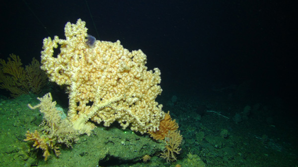
Large gorgonian (Bubblegum coral Paragorgia sp.), Northeast (NE) Saglek Bank. ©Amundsen Science 2021
Description
Bright yellow large gorgonian bubble gum coral (Paragorgia sp.) on the seafloor in Northeast Saglek Bank.
B:
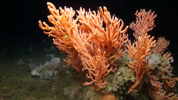
Large gorgonian (Popcorn coral Primnoa sp.), NE Saglek Bank. ©Amundsen Science 2021.
Description
Bright orange large gorgonian popcorn coral (Primnoa sp.) on the seafloor in Northeast Saglek Bank.
C:
Small gorgonian (Bamboo coral Acanella sp.), Southwest Grand Banks. ©CHONe-CSSF-DFO 2007.
Description
Orange small gorgonian bamboo coral (Acanella sp.) on a soft sediment seafloor on Southwest Grand Banks. Pale brittle stars visible in surrounding sediment.
D:
Sea pen (Anthoptilum sp.), Laurentian Channel. ©CHONe-CSSF-DFO 2017.
Description
Orange and burgundy question-mark sea pen (Anthoptilum sp.) anchored in soft sediment in the Laurentian Channel.
E:
Sponge Geodia sp. (white, center) and large gorgonian Primnoa sp. (left), NE Saglek Bank. ©Amundsen Science 2021.
Description
White globular sponge (Geodia sp.) next to a pink large gorgonian coral (Primnoa sp.) among pebbles and sand on the seafloor on Northeast Saglek Bank. Other small corals, sponges, and anemones are seen in the foreground and background.
F:
Black coral (Bathypathes sp.), Davis Strait. ©Amundsen Science 2021.
Description
Bright orange black coral (Bathypathes sp.) on a large rock in Davis Strait.
Annex B: Visual data log template
Guidance on calculating field of view is provided below (A). This is important for calculating density. Data logs should be included for all photo and video data, including B1 to B3. All videos and associated log reports should be provided to DFO and the C-NLOPB.
Reporting: Data logs (B1 to B3) should be delivered electronically in Excel/CSV format. List all equipment used during survey and associated specifications (e.g. camera specifications, presence of laser points and distance between them, estimated ROV survey speed in knots, ROV/camera average distance from the seafloor, number of lights and their specifications).
A. Checklist for calculations of field of view from imagery
Camera view:
Field of view calculated using:
- Definition (examples)
-
- Definition (examples)
-
- Camera aperture angles corrected for seawater refraction
- Height of camera (distance from the seafloor)
- Camera angle of incidence on the seafloor
- Estimation of actual visible field of view (i.e. not impaired). One example is provided in Long et al. (2020)1: Example of paper using trigonometry to calculate field of view area from oblique cameras: Long, S. et al (2020). Identification of a soft coral garden candidate Vulnerable Marine Ecosystem (VME) using video imagery, Davis Strait, West Greenland. Frontiers in Marine Science, 7, 460.
-
- Camera angle of incidence on the seafloor:
- Camera angle of incidence on the seafloor:
- Height above seabed:
- Camera touches the seafloor?
- Speed of vessel:
B1. Fieldwork form for still photographs and video data.
- Date:
- Project number and name:
- Responsible company:
- Project leader:
- Persons in field:
- Reference point for survey area (latitude (lat) and longitude (long)):
- Vessel:
- Describe how field of view area was calculated based on guidance provided in Table A above:
- Imagery data positioning/ navigation descriptors (positions from map, GPS, etc.):
- Imagery data descriptors - (storage medium hard disc, DVD, etc.):
- Geographic Datum:
- Dive/deployment number, if applicable:
- Camera touches the seafloor:
- If yes, overall distance from the seafloor: *value*
- If no, refer to calculations of field of view.
B2. Summary of locational data associated with still photos.
- Date and time Stamp (UTC):
- Transect number:
- Station number:
- Reference site number:
- Photo ID:
- Latitude:
- Longitude:
- Depth:
- Field of view:
- Notes/observations (e.g. reason for taking image, technical difficulties associated with lighting, sedimentation, poor weather conditions, etc.):
B3. Summary of locational data associated with video.
- Date and time Stamp (UTC):
- Transect ID:
- Transect segment number:
- Transect start position (lat and long):
- Transect end position (lat and long):
- Depth:
- Average field of view (see A above):
- If equipment positional data not available, vessel start position in relation to ROV or other visual equipment (lat and long):
- Notes/observations (e.g. reason for taking image, technical difficulties associated with lighting, sedimentation, poor weather conditions, etc.):
Annex C: Coral and sponge condition template
It is recommended that proponents use the descriptions provided on coral and sponge condition as a guide to collect data during the Seabed Investigation Survey and follow-up and monitoring programs.
Depending on the altitude of the imagery system and other technical (speed of ship or device) or environmental factors (clarity of water) it may be challenging at times to discern the details of coral and sponge condition. Some species of sea pens and sponges are particularly difficult and might require close up examination. Table C1 should be filled out for all corals and sponges in the drill center survey area, drill cuttings dispersion model area and the 2 reference sites covered during the Seabed Investigation Survey and during follow-up and monitoring. This table should include a tally of corals and sponges identified in each condition category. A summary of percentage of poor-damaged or dead corals and sponges should be provided. Descriptors (Table C2) and photos (Figures C1-C5) are provided to further aid proponents but are not required for reporting.
| Condition category | Coral condition |
Sponge condition |
Notes on visual coral and sponge description |
Good condition |
- |
- |
- |
Damaged/poor condition |
- |
- |
- |
Dead |
- |
NA |
- |
C1:
Zoanthid (yellow) on Keratoisis (bamboo coral, pale colour), Disko Fan, Baffin Bay. (ArcticNet-CSSF-DFO courtesy of Barbara Neves)
Description
Yellow zoanthid growing on a pale-coloured bamboo coral (Keratoisis) in Disko Fan, Baffin Bay.
C2:
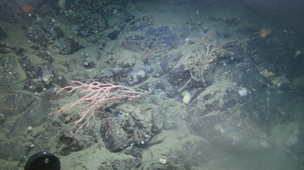
Partially dead Primnoa resedaeformis coral. Polyps (pink tissue) are missing from the bottom half of the specimen, leaving bare skeleton exposed. Photo courtesy of Bárbara Neves (taken using the Comanche ROV aboard CCGS Amundsen in 2021, credit: Amundsen Science).
C3:
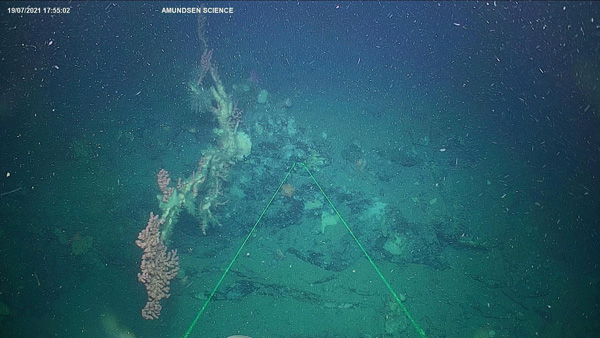
Paragorgia arborea (large gorgonian), partially dead near Makkovik. Pink live tissue and white-ish portion that no longer has tissue, just skeleton. Photo courtesy of Bárbara Neves (taken using the Comanche ROV aboard CCGS Amundsen in 2021, credit: Amundsen Science).
Description
Paragorgia arborea with some live pink tissue visible and a white portion that is just the skeleton without any tissue.
C4:
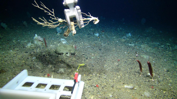
Dead Primnoa (large gorgonian) being collected on Saglek Bank. Photo courtesy of Bárbara Neves (taken using the Comanche ROV aboard CCGS Amundsen in 2021, credit: Amundsen Science).
Description
Dead Primnoa (large gorgonian coral) being lifted off the seafloor by the metal arm of a Remote Operated Vehicle (ROV) on Saglek Bank.
C5:
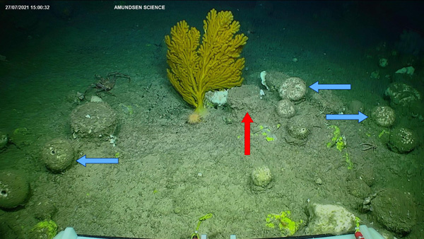
Sponges (e.g. Geodia sp.) at Northern Labrador (Hatton Sill, 686m depth). Blue arrows showing sponge with shape still intact with some natural sedimentation. Red arrow indicating a sediment covered sponge, health status unknown (S. Leys and C. Dinn, personal communication, February 11, 2022). Photo courtesy of Bárbara Neves (taken using the Comanche ROV aboard CCGS Amundsen in 2021, credit: Amundsen Science).
Description
Seafloor in Northern Labrador with several corals and sponges visible. Three arrows point at round sponges with shapes that are still intact, but that are covered by natural sedimentation. Another arrow points at a sediment-covered sponge with unknown health status.
| Coral condition | Coral description |
|---|---|
Good |
|
Poor/damaged |
|
Dead |
|
| Sponge condition | Sponge description |
|---|---|
Good |
|
Poor/damaged |
|
Unable to determine if a sponge is dead with visual survey alone. |
- |
Annex D: Other Effective Area-Based Conservation Measures (OECM) Plan template
For use by Fisheries and Oceans Canada
Date received:
For use by Applicant
1: Identification of Other Effective Conservation Measures (OECM)
- Name of OECM.
2: Contact information
-
2.1 Primary contact/applicant
- Name:
- Job title:
- Address:
- Telephone number:
- Email:
2.2 Individual responsible (if the plan is submitted by an institution or organization)
- Name of the individual responsible for the proposed activity:
- Job title:
- Address:
- Telephone number:
- Email:
3: Vessel information
- Vessel name:
- State of registration:
- Registration number:
- Radio call sign:
- Name and address of the owner of the vessel:
- Name of the master of the vessel:
- Name of any operator of the vessel:
4: Dates
- Proposed date of the vessel’s first entry into the OECM:
- Proposed date of the vessel’s final exit from the OECM:
- Proposed alternative dates:
- Date(s) for the carrying out of the entirety of the proposed activity:
- Date(s) for the carrying out of sub-activities (if applicable) in the OECM:
- Sub-activities
- Seabed investigation Survey (date and time/duration)
- Exploration drilling (date and time/duration)
- Follow up and monitoring (date and time/duration)
5: Location of activity inside the OECM
- Figure Indicating position of activity within OECM
- Figure of Survey Design (including drill cuttings dispersion model results)
- Geographic Coordinates (e.g., WGS 84, NAD 84)
6A: Potential impacts on corals and sponges: Direct impact
Potential impacts of exploration activities on corals and sponges may include:
- removal (mortality)
- dislodgement
- injury
- inhibition of feeding
- other behavioural impacts due to sedimentation
Localized impacts on coral and sponge abundance and richness, as well as hampering of functional roles as habitat to other species are also possible. Chemical toxicity, physical effects on tissues, and habitat destabilization may also occur.
Direct impact: Include the physical footprint (m2) of the wellhead and associated infrastructure
(direct impact area = _________ )
6B: Potential impacts on corals and sponges: Indirect impacts
Smothering from drilling discharges and from natural sedimentation may occur. The impact of increased sedimentation on sea pens specifically has not been studied. However, sedimentation reduces the ability of some coral species to feed and in some cases may lead to polyp mortality (Gass and Roberts 2006; Brooke et al. 2009; Liefmann et al. 2018).
- Provide a figure of the drill cuttings dispersion model extents to 6.5 mm PNET and 1.5 mm PNET for sensitive species
- Provide estimated area covered by drill cuttings dispersion model extents to 1.5 mm PNET.
- Type of drilling mud used
- Brief description of chemical composition (e.g. weighing agent being utilized)
7: Purpose/description of the proposed activity (in compliance with EA conditions and regulations)
8: Description of the proposed survey equipment to be used when carrying out the activity
- Visual equipment:
- Equipment used for measuring extent and thickness of drill cuttings:
- Equipment used for sediment collection, if applicable:
9: Pre-drill Seabed Investigation Survey plan
- Date plan submitted:
- Figure of survey design (to scale):
- Drill center survey area and associated transects
- 16 radials in modified cloverleaf pattern
- Model transects covering drill cuttings dispersion model area
- Guardrails
- Reference sites
- Figure of survey design (to scale):
- Anchor survey description, if applicable
10: Pre-drill Seabed Investigation Survey results
- Please include an overview of the following:
- Figures of functional group(s) presence over survey area
- Abundances and densities of functional groups on all radials and model transects
- Coral condition template and summary
- Imagery data and data log
- Description of sediment collection, if applicable
- Description of specimen samples (location, identification), if applicable
- Description of photos taken (location, identification), if applicable
- Please submit all specimens to DFO.
11: Avoidance and/or mitigation measures
- Describe all proposed avoidance and/or mitigation measures to be implemented
- Relocation:
- Option 1: Proponent relocation of site in real-time. Data used in decision making also submitted to DFO. Include a figure outlining original site and new site.
- Option 2: DFO provides recommendation for relocation including rationale for decision.
- Redirection: Such as subsea cuttings transport system.
- Other mitigations: if applicable and in consultation with C-NLOPB and DFO:
- Rationale:
12: Monitoring approach
- Figures of survey design, drill cuttings dispersion model(s), sampling stations and reference sites.
- Describe approach to determine accuracy of model predictions including measurement of drill cuttings extent and thickness, as well as coral and sponge condition.
- Describe monitoring activities that will be used to determine the effectiveness of mitigation measures (including impacts on corals and sponges).
13: Reporting schedule
- Frequency at which updates with respect to the implementation of the mitigation measures and the results of monitoring activities will be provided to DFO and the C-NLOPB.
- Date modified: