
Best Management Practices for the Protection of Freshwater Fish Habitat in Newfoundland and Labrador
On this page
- Preface
- 1.0 Introduction
- 2.0 Regulatory requirements
- 3.0 Habitat protection mitigation techniques
- 3.1 Erosion / sedimentation control
- 3.2 Streambank stabilization
- 3.3 Watercourse crossings
- 3.4 Site preparation, buffer zones, decommissioning and rehabilitation
- 3.5 Instream work in the dry
- 3.6 Water withdrawal
- 3.7 Stormwater drains
- 3.8 Borrow sites / quarries and asphalt / cement plants
- 3.9 Blasting / explosives
- 3.10 Dredging
- 3.11 Forest harvesting and related activities
- 3.12 Linear development
- 3.13 Mineral exploration
- 3.14 Urban development
- 3.15 Hydroelectric developments
- 4.0 Glossary
- 5.0 Bibliography
- Appendix A
- Appendix B
- Contact information
© Her Majesty the Queen in Right of Canada, 2022.
Paper: Cat. No. Fs114-28/2021E ISBN 978-0-660-40505-6
PDF: Cat. No. Fs114-28/2021E-PDF ISBN 978-0-660-40504-9
Published by:
Fisheries and Oceans Canada
Ecosystems Management Branch
Fish and Fish Habitat Protection Program
Newfoundland and Labrador Region
P.O. Box 5667
St. Johns, NL A1C 5X1
Correct citation for this document is:
Fisheries and Oceans Canada. 2022. Best Management Practices for the Protection of Freshwater Fish Habitat in Newfoundland and Labrador. St. John’s, NL. vi + 80 p.
Preface
Best Management Practices for the Protection of Freshwater Fish Habitat in Newfoundland and Labrador has been developed to serve as a reference for planners, developers, contractors and regulatory agencies in addressing freshwater fish and fish habitat protection issues arising as a result of proposed project development activities that occur in or near freshwater. This document provides an update to a previous version entitled Guidelines for Protection of Freshwater Fish Habitat in Newfoundland and Labrador (Gosse et al., 1998),which had combined the information contained in the earlier Fisheries & Oceans Canada (DFO) guideline documents including: Resource Road Construction Fish Habitat Protection Guidelines (McCubbin et al., 1990) and Urban Development Guidelines for Protection of Fish Habitat in Insular Newfoundland (DFO and LGL Ltd., 1990).
1 Introduction
These best management practices have been developed to serve as a reference for planners, developers, contractors, and regulatory agencies in addressing freshwater fish and fish habitat protection issues arising as a result of proposed project development activities.
Protection is an essential step in maintaining the productivity of fish habitat. Habitat protection contributes to the conservation and enhancement of commercial, recreational, and Aboriginal fisheries resources. Specific requirements for the protection of fish and fish habitat are set out in Canada’s Fisheries Act and its associated regulations. Other federal, provincial, or municipal legislation addressing fish and fish habitat protection may also apply to proposed developments.
Most problems associated with development-related activities, regardless of scale, are often the result of poor planning and design, improper site location, and inappropriate construction practices. This document identifies common project development activities that have the potential to adversely impact the aquatic environment and offers information on measures to reduce or eliminate these harmful impacts. The proper implementation of appropriate mitigation techniques can prevent or minimize impacts on productive fish habitat and fish populations.
1.1 Scope and purpose
The purpose of this document is to provide planners, developers, contractors, and regulatory agencies with “best management practices” that are aimed at protecting freshwater fish and fish habitat during proposed project development activities. The following highlights the format of this document:
- Section 1 outlines the purpose of this document within the context of fish habitat management in Newfoundland and Labrador. A description of key fish habitat requirements is provided to illustrate the linkage between fish and fish habitat and to emphasize the importance of habitat protection.
- Section 2 provides an overview of regulatory requirements that are relevant to instream works within the province of Newfoundland and Labrador.
- Section 3 outlines mitigation techniques aimed at reducing or eliminating the potential harmful impacts of project development and operational activities on fish and fish habitat.
1.2 Fish and fish habitat
The freshwater fishery resource of Newfoundland and Labrador is unique among areas of comparable latitude in North America since salmonids are predominant in virtually all waterbodies. Salmonid species include:
- Atlantic salmon
- brook trout
- brown trout
- rainbow trout
- lake trout
- Arctic char
- whitefish
Other freshwater fish found in the province include:
- eel
- stickleback
- smelts
- Northern pike
- others
Appendix A provides species specific information and habitat requirements.
In order for fish populations to thrive and reproduce, fish habitat should provide shelter, security and nourishment. All salmonids have similar freshwater habitat requirements:
- clear, clean water
- cool water temperatures
- a high oxygen supply
- shelter
- food from both aquatic and terrestrial sources
- a combination of appropriate habitat types
- suitable substrates
- adequate stream flow
- access to a variety of habitats for various life processes (Figure 1.1)
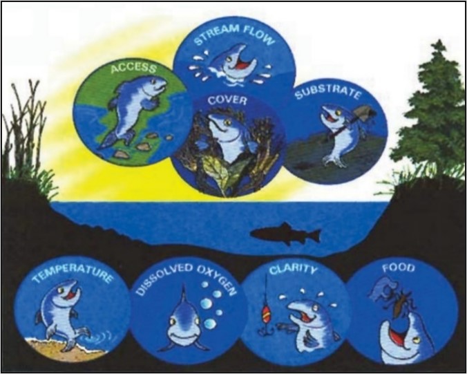
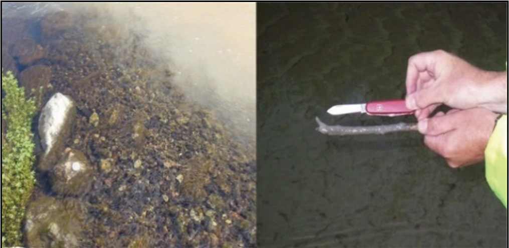
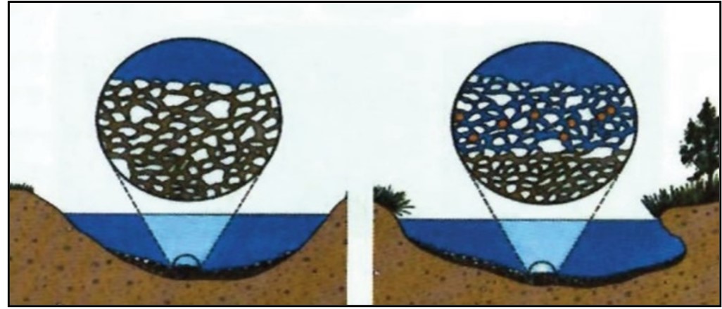
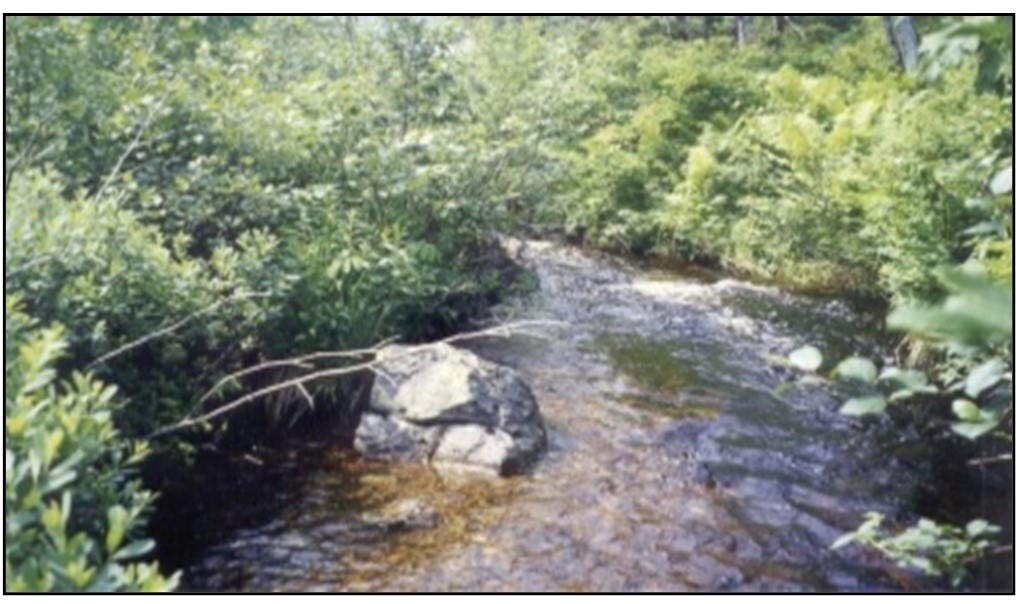
Water clarity is important for various reasons. Suspended sediment reduces visibility, making it difficult for fish to locate and capture prey. Suspended sediment (Figure 1.2) can also damage fish gills causing injury, mortality, and increased susceptibility to disease and predation. Settled sediments can infill pools and riffles, reducing the availability and quality of spawning and rearing habitat for fish (Figure 1.3). Infilling occurring during spawning, incubation, or hatching periods can smother eggs and alevins. Sediment deposits can also reduce the food supply by displacing insect larvae that reside on the stream bottom.
Clean water, free of toxins and pollutants, is essential for healthy and productive fish populations. The introduction of pollutants into the aquatic environment can seriously affect plants, animals, and microorganisms, thereby altering the structure of the aquatic ecosystem. Pollutants can be directly lethal to fish, can make fish more susceptible to other stressors, or can accumulate in fish tissues making them unsafe for human consumption.
Water temperature is a critical factor in salmonid survival. Fish may display signs of stress at temperatures above 22°C and mortalities have been recorded at 27°C. Developing eggs also have strict cool temperature requirements and hatching success can be greatly affected by increases in temperature. Factors that help to maintain cool water temperatures include deep, flowing steadies and pools, shading by streamside vegetation, and intact groundwater sources.
Dissolved oxygen in the water is absorbed by fish through the gills and transported around the body in the blood. Aquatic plants and algae introduce oxygen into the water as a product of photosynthesis. Turbulence is also important for oxygenating water. Dissolved oxygen levels are reduced in warm water, another important reason for cool water maintenance.
Shelter is necessary for avoiding predators and accessing shaded areas during periods of warm temperatures. Stumps, logs, and other instream debris make excellent hiding places. Fish rest behind instream boulders or in undercut streambanks, and dart out into the current to catch drifting food. These areas are also velocity shelters that enable fish to conserve energy.
Food supply in the aquatic environment must be plentiful and diverse to sustain the productivity of a watershed. A healthy pond or stream contains hundreds of varieties of plant and animal life, much of which is microscopic. Leaf litter and woody debris that fall into a stream are broken down and decomposed by microorganisms and insect larvae. These insect larvae, in turn, may be eaten by juvenile fish. Larger fish may prey upon worms, amphipods, and smaller fish.
Habitat variety is important for providing key habitat components to all life stages within a fish population. Salmonids use different sections of a stream at different life cycle stages (see Appendix A). The usefulness of these sections is determined by substrate size, water depth, and flow.
Suitable substrate is essential for fish productivity. Fish need well-aerated, gravel-bottomed areas for spawning. Rearing areas require larger substrates, which provide young fish with resting areas and shelter from predators. Adequate stream flow is required by fish to ensure that habitat is accessible. Stream flow also influences other habitat factors such as water temperature and dissolved oxygen levels. Flow is required to provide oxygen to developing eggs and remove wastes. Deeper, slow-moving stream sections make good nursery and rearing areas for newly-hatched and growing salmonids. Excessive flow and high water velocities can displace fish from habitat and create migration barriers. Pools and ponds are used for overwintering. Flow ultimately determines the available space (wetted area) for fish. Access to habitat is crucial in maintaining fish populations. Obstructions to fish passage can alienate large areas of productive spawning and rearing habitat.
2 Regulatory requirements
In Newfoundland and Labrador, work in and near waterbodies is regulated under both federal and provincial legislation. Fisheries and Oceans Canada conserves and protects fish and fish habitat by applying the fish and fish habitat protection provisions of the Fisheries Act, in combination with other applicable federal laws and regulations related to aquatic ecosystems, including:
- the Species at Risk Act
- the Oceans Act
- the Aquaculture Activities Regulations
- the Aquatic Invasive Species Regulations
The fish and fish habitat protection provisions of the Fisheries Act regulate works, undertakings or activities that risk harming fish and fish habitat. Specifically, they include the 2 core prohibitions against persons carrying on works, undertakings or activities that result in the “death of fish by means other than fishing” (subsection 34.4(1)), and the “harmful alteration, disruption or destruction of fish habitat” (subsection 35(1)) (Fisheries and Oceans Canada, 2019a).
When planning and implementing works, undertakings or activities, it is important to do so in a manner that avoids harmful impacts, specifically the death of fish and the harmful alteration, disruption or destruction of fish habitat. If proponents believe that their work, undertaking or activity may result in harmful impacts to fish and fish habitat, they can contact Fisheries and Oceans Canada. The department will work with proponents to assess the risk of their proposed work, undertaking or activity resulting in the death of fish or the harmful alteration, disruption or destruction of fish habitat and provide advice and guidance on how to comply with the Fisheries Act (Fisheries and Oceans Canada, 2019a).
Authorizations, licenses or permits may be required in order to proceed with works, undertakings or activities. This can include instances where the proposed activity has the potential to impact fish and fish habitat, as well as:
- could affect a Species at Risk listed as endangered or threatened, or their residence or critical habitat
- will be carried out within a Marine Protected Area (MPA), or other conservation area
- could introduce live fish into fish habitat or transfer live fish to or between fish rearing facilities
- is associated with controlling aquatic invasive species
Proponents are encouraged to contact their regional DFO office to ensure all applicable regulatory requirements are met.
Provincial legislation within Newfoundland and Labrador also regulates work in or near waterbodies. The provincial Environmental Protection Act and the Water Resources Act apply to any alteration of a waterbody and a permit must be obtained from the Provincial Government.
Under certain circumstances, other municipal, provincial, or federal legislation may apply. For example, municipal government, town and city councils may require that you obtain zoning and building permits for your proposed work. Environment and Climate Change Canada exercises control of specific contaminants (e.g. oil, PCB's, etc.) and accidental spills of toxic substances. If a proposed project could affect waterways or wetlands that are important to migratory birds then the Canadian Wildlife Service of Environment and Climate Change Canada will review the project. Similarly, if the project has the potential to impact beaver, moose, caribou, or other wildlife species, it may require review by the provincial Department of Fisheries, Forestry and Agriculture.
In summary, authorizations, licenses, or permits from both federal and provincial levels of government may be required for instream work. It is a good practice to contact DFO, Environment and Climate Change Canada, appropriate provincial departments, and sometimes, Crown Lands. Also, if your project is within the boundaries of a municipality or a municipal water supply area, the town or city council office should be consulted to discuss your proposed project to ensure all legal environmental requirements will be met. In all cases, it is the responsibility of the proponent to comply with applicable legislation and ensure the requirements of federal, provincial, and municipal jurisdictions are followed.
For many project developments and associated activities there are issues that typically have to be addressed with respect to freshwater fish and fish habitat protection. Common to many project developments regardless of overall project scale (i.e. small or large) are issues such as:
- erosion/sedimentation control
- site stabilization
- site clearing
- buffer zones
- watercourse crossings
- fish passage
The following section presents both general construction activity and project specific mitigation techniques aimed at reducing or eliminating potentially harmful impacts on fish and fish habitat. These techniques are often used most effectively in combination with one another.
3 Habitat protection mitigation techniques
3.1 Erosion / sedimentation control
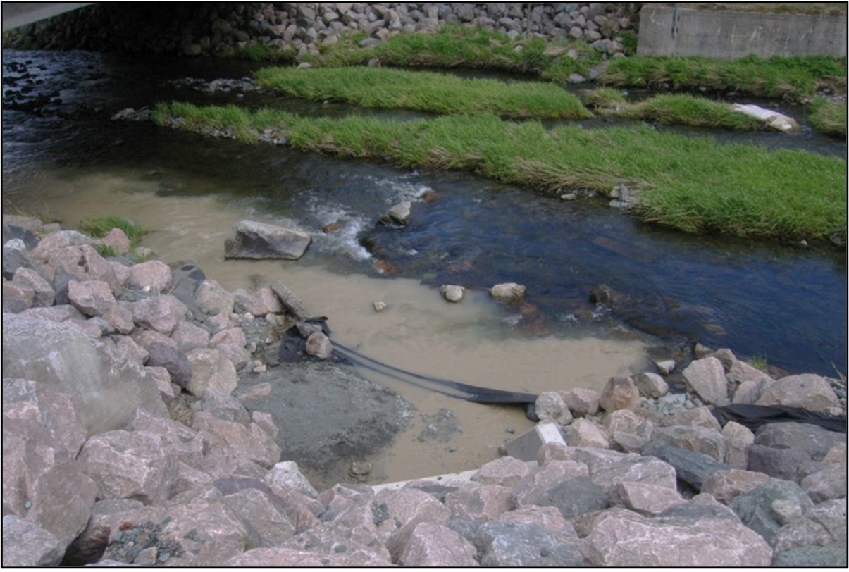
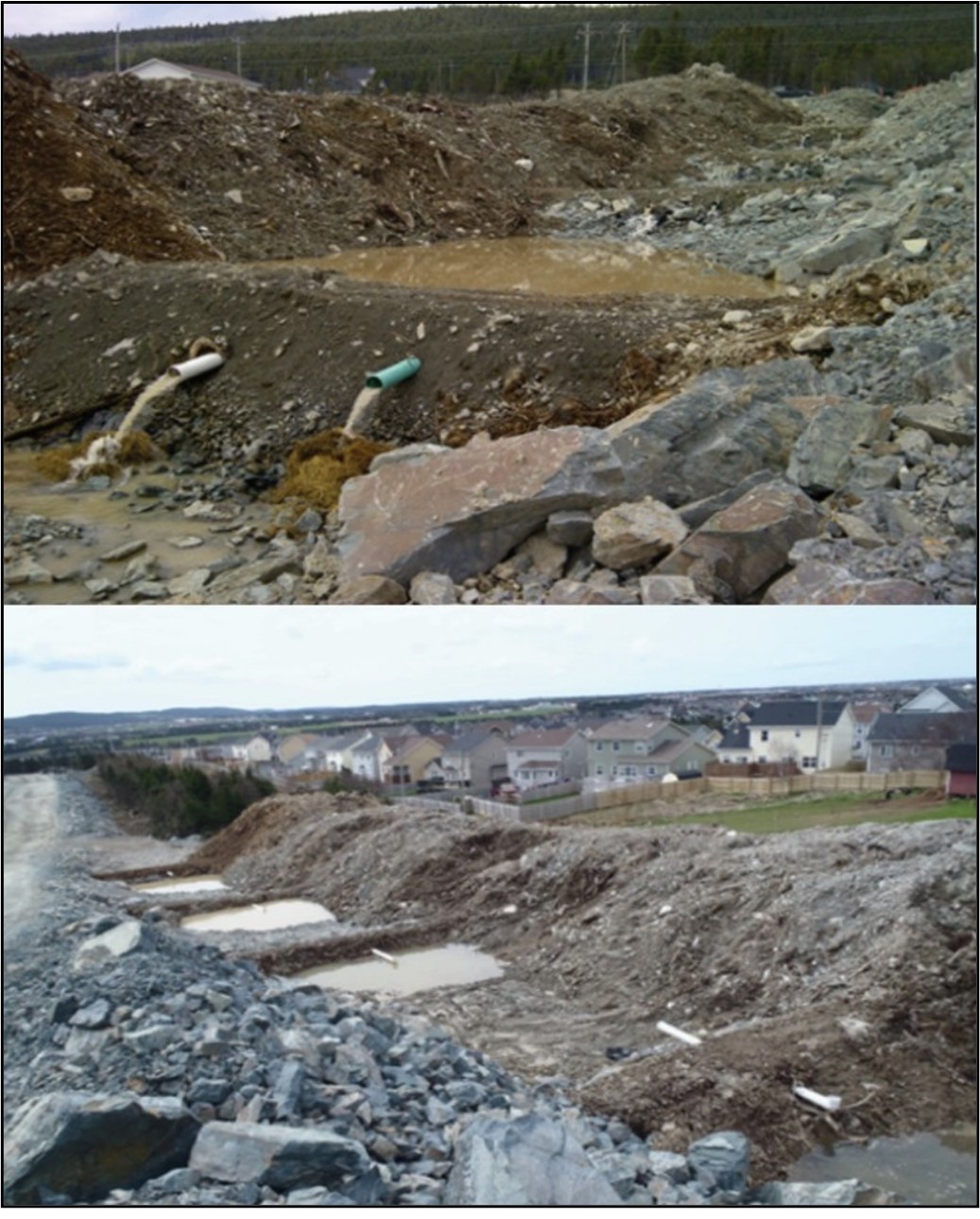
Land development activities such as clearing land, grading slopes, road building, excavating and stockpiling materials can lead to the erosion of soils into nearby watercourses that contain fish and fish habitat (Figure 3.1). Sedimentation of watercourses can have detrimental effects on fish and fish habitat. Suspended sediment reduces water clarity and can cause damage to gills. Sediment can also settle onto the bottom of watercourses, smothering eggs and/or rendering gravel substrate unsuitable for spawning. Even after the replacement and compaction of slopes and surfaces, gully and channel formation can occur and lead to subsequent erosion. Therefore, on and off-site runoff management is a key factor in erosion and sediment control. Management techniques, such as preparing and covering disturbed soils, revegetating slopes, and lining runoff ditches, early in the project assist in reducing the potential for erosion.
An erosion and sediment control plan is developed and implemented for the site that minimizes risk of sedimentation of the waterbody during all phases of the project. Erosion and sediment control measures should be maintained until all disturbed ground has been permanently stabilized, suspended sediment has resettled to the bed of the waterbody, or settling basin and runoff water is clear.
The plan should, where applicable, include:
- Installation of effective erosion and sediment control measures before starting work to prevent sediment from entering the waterbody
- Measures for managing water flowing onto the site, as well as water being pumped/diverted from the site such that sediment is filtered out prior to the water entering a waterbody. For example, pumping/diversion of water to a vegetated area, construction of adequately sized settling ponds or other filtration system
- Site isolation measures (e.g., silt boom or silt curtain) for containing suspended sediment where in-water work is required (e.g., dredging, underwater cable installation)
- Measures for containing and stabilizing waste material (e.g., dredging spoils, construction waste and materials, commercial logging waste, uprooted or cut aquatic plants, accumulated debris) above the high water mark of nearby waterbodies to prevent entry/re-entry
- Regular inspection and maintenance of erosion and sediment control measures and structures during all phases of the project
- Repairs to erosion and sediment control measures and structures if damage occurs
- Removal of non-biodegradable erosion and sediment control materials once site is stabilized
In general, provisions for appropriate erosion and sedimentation control should also consider the following:
- Plan the development to suit the existing terrain and site conditions
- Schedule development to minimize potential impacts associated with erosion
- Retain existing vegetation where possible (Figure 3.2)
- Re-vegetate/protect denuded areas and bare soils and divert runoff away from denuded areas
- Minimize the length and steepness of slopes, where possible, and provide erosion protection for temporary and long-term/permanent slopes
- Minimize runoff velocities and erosive energies by utilizing interceptor ditches, minimizing gradients, and maximizing lengths of conveyance ditches
- Design development to minimize or control runoff associated with project construction, operation and decommissioning or abandonment activities
- Retain eroded sediments on site with erosion and sediment control structures
- Plan, inspect and maintain erosion and sediment control structures to ensure effective and efficient operation
In addition to the above general practices, Sections 3.1.1 through 3.1.6 provide details on some specific erosion/sedimentation control mitigation techniques (i.e. silt fence, filter fabric dam, rock check dam, settling ponds, ditches, stabilized access to site, straw barrier/bale structure, matting and vegetation, and grading). When using manufactured erosion control materials, manufacturer’s specifications should also be consulted. Further, appropriate and timely stabilization of disturbed areas, as presented in Section 3.2, can facilitate sedimentation and erosion control.
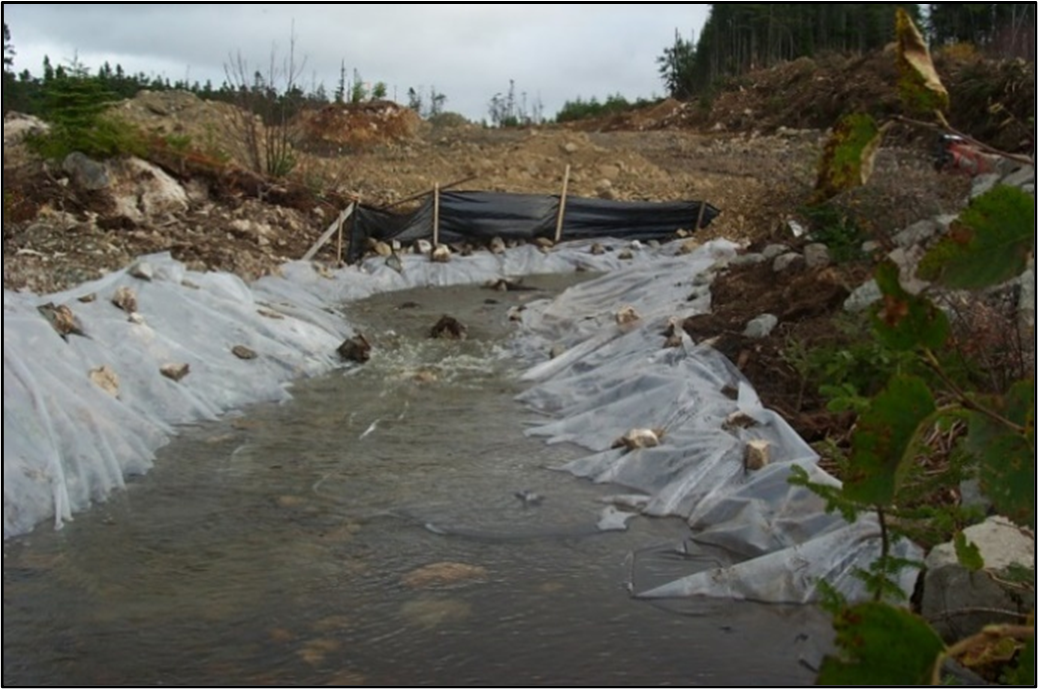
3.1.1 Filter fabric dam / silt fences
Filter fabric dams are temporary barriers that provide an effective filter for sediment-laden runoff from disturbed slopes and surfaces. They are used in ditches to remove sediment from collected water prior to the release of this water into a natural watercourse. Silt fences are constructed with filter fabric and posts or stakes, and are typically installed in series at appropriate intervals along drainage ditches in development areas. Silt fences surround a disturbed site or contoured exposed slope (maximum steepness 2:1), effectively trapping the sediment close to the erosion source and preventing sedimentation of the aquatic environment via site runoff. Silt fences and filter fabric dams have a limited retention capacity and are not designed for long term control of sedimentation. These structures also require ongoing maintenance.
The best management practices for the effective use of filter fabric structures are:
- Filter fabric structures are designed for temporary use only
- Filter fabric structures should not be used in natural watercourses and have minimal effectiveness when placed in locations of continuous flow and/or moderate to high water velocities. Use should be limited to situations in which only surface runoff is expected
- Filter fabric/silt fences should be installed on the lower perimeter of slopes (lower 1/3 to 1/2 of site) and in areas where the erodibility is high and/or it is desirable to contain waterborne movement of eroded soils (i.e. the bottom of cut or fill slopes, material stockpiles, and disturbed natural areas)
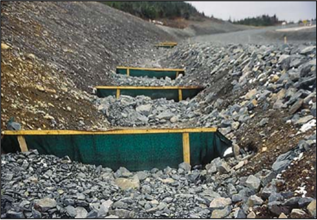
- More than one filter fabric dam should be installed to ensure maximum removal of sediment prior to the entry of collected water into the receiving watercourse and filter fabric dams should be installed in series (Figure 3.3)
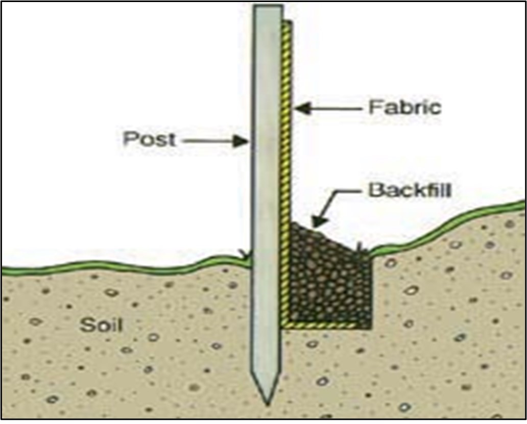
- For ditch installations, the filter fabric dam should be appropriately embedded in the ditch bottom and sides (e.g. 100 mm minimum) to prevent the movement of fines under or around the dam (Figure 3.4). Wooden stakes should be installed on the downstream side of the trench and filter fabric attached to the upstream side of the stakes. Adjoining sections of filter fabric should be sufficiently overlapped (e.g. minimum 150 mm) to prevent the movement of fines around or through the seam area
- Accumulated sediment should be removed regularly from the silt fence or filter fabric dam and disposed of in a manner that prevents subsequent entry into any watercourses (e.g. material should be disposed of at a landfill)
- Damaged sections of fabric should be repaired or replaced. Dams should be inspected to ensure that water is not flowing under or around the filter fabric and that the structure is appropriately functioning to retain sediment
- Filter fabric dams and silt fences should not be removed until all site work has been completed and disturbed areas stabilized. All accumulated sediment should be removed and disposed of in an appropriate manner (e.g. at a landfill approved by the appropriate regulatory agency) prior to removing the filter fabric structure
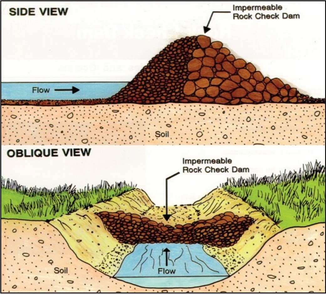
3.1.2 Check dam
Check dams (Figure 3.5) can be temporary or permanent and are used to prevent erosion and control sedimentation arising from roadside ditches. Check dams are structures used to prevent the erosion of ditch bottoms by slowing the velocity of concentrated runoff and by collecting and holding moisture and sediment in the ditch bottom. These structures are generally constructed with consideration for the availability of materials and whether the check dams are to be permanent or temporary. Check dams can be constructed of locally available materials and are relatively easy and economical to construct. Materials typically used include:
- brush
- rock
- gabion baskets
- planks
- sodded earth fill
- sandbags
When utilizing check dams, the following best management practices are provided:
- Check dams are typically limited to treating runoff from small drainage areas and should not be used in natural watercourses. Therefore, several small check dams may be preferable to a few larger dams to reduce runoff and maximize the sediment-trapping capacity
- Check dams should be constructed to provide an impermeable structure, including lining with impermeable material, such as plastic or polyethylene sheeting, if only larger stones are available
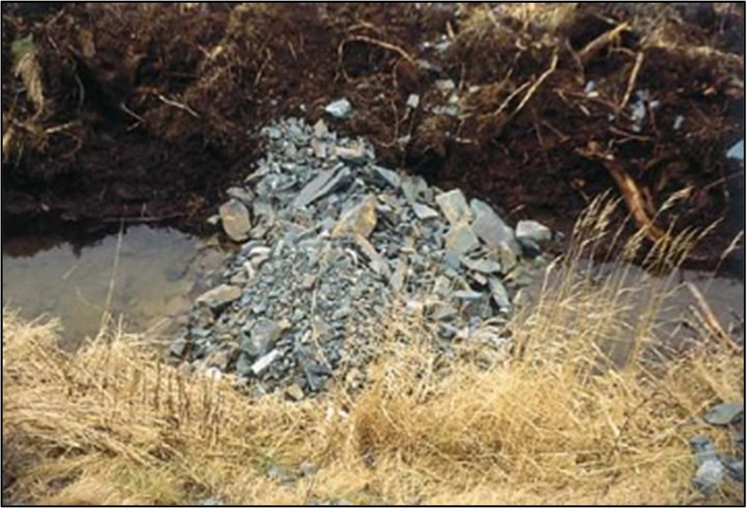
- The center of the check dam should be lower than the sides to enable the movement of accumulated water over the dam, while settled sediment is retained by the sides and lower portion of the dam (Figure 3.6)
- The check dam and ditch should be stabilized with riprap or other non-erodible material
- The check dam should be regularly inspected and accumulated sediment removed. Material removed from the check dam should be disposed of in an appropriate manner (e.g. at a landfill approved by the appropriate regulatory agency) to ensure that sediment does not enter the aquatic environment. Ensure that accumulated sediment is removed and disposed of prior to the removal of a temporary check dam
3.1.3 Settling ponds
Settling ponds/basins (Figure 3.7) are used to intercept and retain sediment-laden runoff. These structures allow sediment to settle out, thereby reducing the amount of sediment leaving the disturbed area and protecting fish habitat into which runoff is flowing. The effectiveness of settling ponds is influenced by particle size, settling characteristics, settling time, and surface area. Settling ponds should be installed at the development area prior to any excavation or other construction-related activities. These ponds are most effective for sedimentation control on a relatively short-term basis.
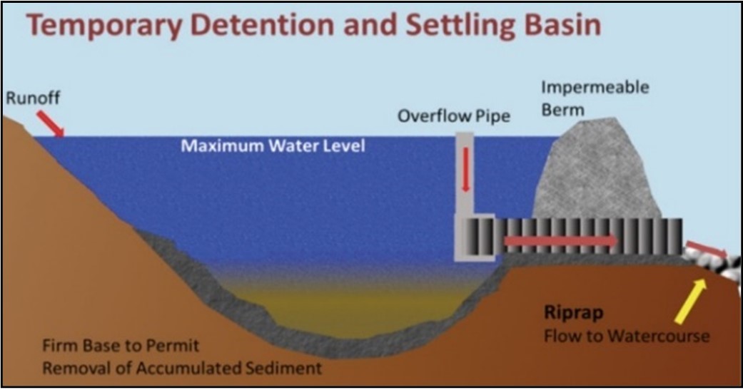
When using settling ponds, the following best management practices should be followed:
- Install during initial site development before any grubbing of the area occurs
- Settling ponds should be constructed so that the length is at least four times the width
- Settling ponds are most effective when several are used in series, particularly if long-term activity of several weeks or more is planned. A minimum of 2 ponds should be provided (Figure 3.8)
- When necessary, depending on the permeability of the pond bottom and sides, it may be necessary to line the bottom with plastic or other impermeable material (Figure 3.9)
- A pipe should be installed near the top of a settling pond in such a manner that water is discharged from the top of the water column. There are a number of alternatives to this method of settling pond construction involving the use of various detention devices such as precast manholes and using natural topographic features
- A chemical additive, known as flocculant, may increase the rate at which sediment particles settle out of the water column. Any questions regarding the use of chemicals should be directed to the appropriate regulatory agencies
- It may be necessary to remove and dispose of accumulated sediment from settling ponds in order to maintain operating capacity
- Settling ponds should be filled in and stabilized when no longer required. Impermeable liners, such as plastic, should be removed and appropriately disposed of
3.1.4 Ditches
Ditches can be used to reduce the amount of water entering cleared land and causing erosion, as well as to collect sediment-laden water and direct it to settling ponds. Roadside ditching allows:
- drainage of the roadbed
- restricts vegetative growth
- corrects for deficiencies such as:
- erosion
- non-conformity in grade, line, or cross section
- water ponding on the roadway
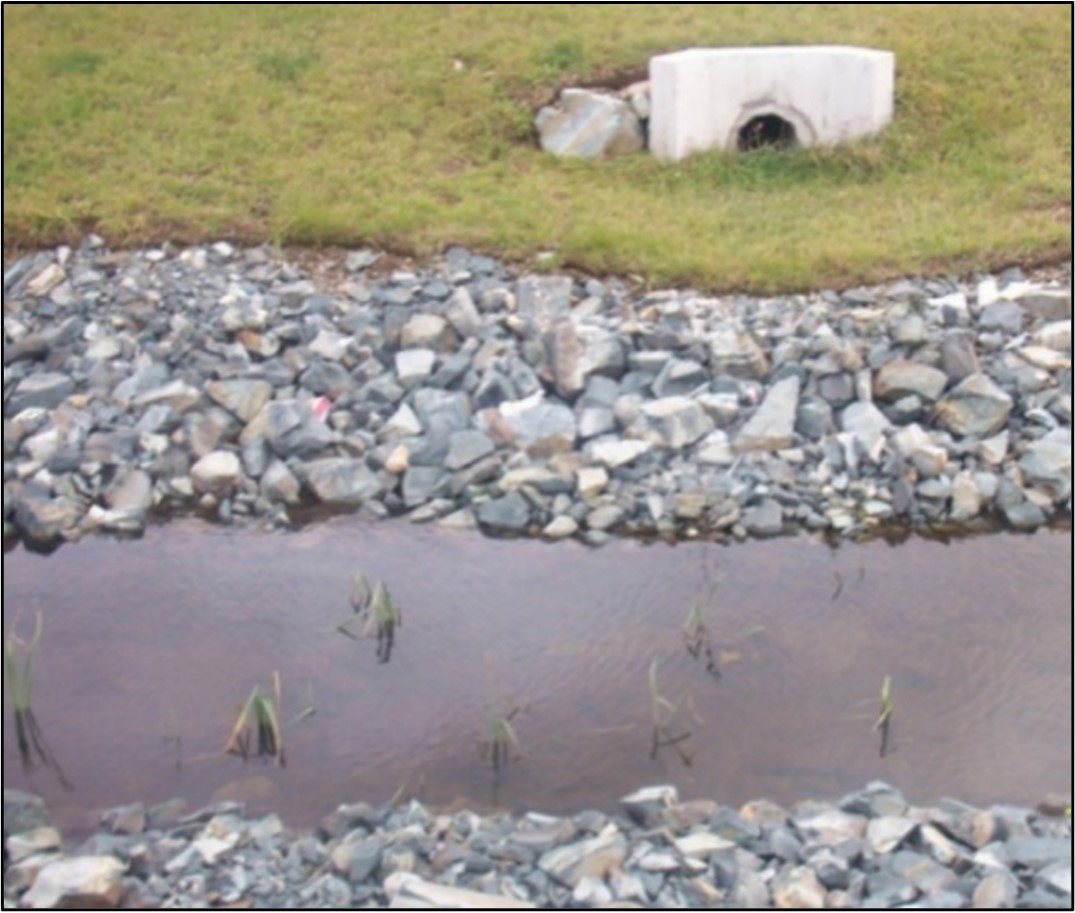
Interceptor ditches are temporary or permanent structures designed to intercept and carry clean surface runoff away from erodible slopes, reducing potential surface erosion and limiting the amount of runoff requiring treatment. Alternatively, these ditches can collect sediment-laden runoff from slopes and carry it, without further erosion, to treatment areas or settling ponds. Interceptor ditches usually have to be excavated and should be stabilized to prevent erosion and sedimentation.
Ditches, particularly new ditches, can transport large volumes of sediment. Sediment discharged into watercourses can adversely affect fish habitat and aquatic life. When using ditches the following best management practices should be followed:
- Ditches should be stabilized and should not discharge open ended into a watercourse. Ditches should flow into vegetated areas located upslope of watercourses to allow the trapping of sediment prior to the entry of the runoff into the watercourse (Figure 3.10)
- The location of and access to interceptor ditches should be determined following review of the topography, the existing or planned drainage pattern, and subgrade conditions. Ditches should be laid out following the site contours, if possible, and constructed during the initial site clearing
- In sidehills or similar areas, ditches should be installed on uphill sides of roads to intercept seepage and runoff
- Where ditches have been excavated in areas with erosion-prone soils, the ditches should be immediately lined with non-erodible material
- Cross drainage culverts and take-off ditches (Figure 3.11) should be incorporated to carry water away from the road and into the surrounding vegetation, where sediments can be filtered
- In addition to take-off ditches, roadside ditches with long slopes may require rock check dams to reduce water velocity in the ditch, control erosion, and prevent sedimentation of nearby watercourses
- Where the topography does not permit the construction of take-off ditches, settling ponds should be used to trap sediment and prevent sedimentation of nearby watercourses
- A regular maintenance program is necessary to keep ditches in good working order. Sediment has to be removed from rock check or filter fabric dams; these structures may have to be adjusted or repaired; and additional stabilization may be necessary. In addition to regular inspections, all ditches and structures should be inspected after heavy rainfall or during periods of sustained precipitation
- Temporary ditches should be filled and vegetated when no longer required


3.1.5 Straw barrier / bale structure
Straw barrier/bale structures are temporary mitigations that act as barriers to intercept runoff moving down a slope, both reducing the potential of erosion as well as controlling sediment. These barriers work in a manner similar to check dams and geotextiles. Straw barrier/bale structures should be installed in runoff paths and other possible locations of concentrated flow to inhibit the migration of erodible soils. The number and spacing of bales will depend upon the nature of the construction operations; however, these structures are effective at controlling sediment close to the source. When utilizing straw barrier/bale structures, the following points should be followed:
- Straw barriers should not be used in natural watercourses
- These barriers are short-term measures and are effective only when treating runoff from very small drainage areas (less than 1 ha)
- Straw barriers can be used in shallow ditches or along the side of waterways or property boundaries during construction of other erosion control measures
- Straw barriers should be staked into the ground to ensure stability
- The maximum life is approximately 3 months, and may be considerably less under warmer conditions and successive storms
- Accumulated sediment should be removed regularly and disposed of in an appropriate manner (e.g. a landfill approved by the appropriate regulatory agency) to prevent entry into the aquatic environment
3.1.6 Matting and vegetation
Temporary matting, such as jute mat, glass fiber mat, polyethylene sheeting, woven paper mat, and vegetative mat (commonly called erosion control blanket), is used to provide stabilization for the surface of steep slopes and ditches, and to protect newly-seeded soil from erosion. These mats act as mulch to hold moisture in and allow grass to grow through (Figure 3.12). The mats absorb raindrop impact, reduce runoff velocity, improve infiltration, bind soil particles with roots, and provide immediate erosion control until permanent vegetation can be established.

The rapid establishment of a vegetation cover is generally recognized as the most effective form of surface erosion control. Seeding, hydro seeding, sodding, shrubs, and/or small trees or vegetative mats are some natural forms of stabilization methods that offer permanent surface protection.
When utilizing matting and vegetation as forms of erosion control, the following best management practices are provided:
- When immediate protection is required or other protective measures are not feasible, polyethylene sheeting or tarps can be used. Sheeting or tarps should be well anchored and repaired immediately if maintenance is required
- If a biodegradable pre-seeded erosion control mat is used, the mat should be stapled to the soil surface and anchored at the top
- When seeding, soil surfaces should be rough. Areas should be covered with mulch immediately after seeding
- Selection of the type of vegetative cover depends upon the amount of surface water runoff across the disturbed area. Vegetative protection may be ineffective unless seepage is controlled. Site conditions and time of year should also be considered when selecting the most appropriate type of vegetative cover
- Hydroseeding should be carried out as soon as possible after completion of the surface preparation. Final preparation of slopes and other exposed earth should be done as cut and fill areas are completed, to enable seeding to be done in stages as work progresses
- Sods should be appropriately staked in
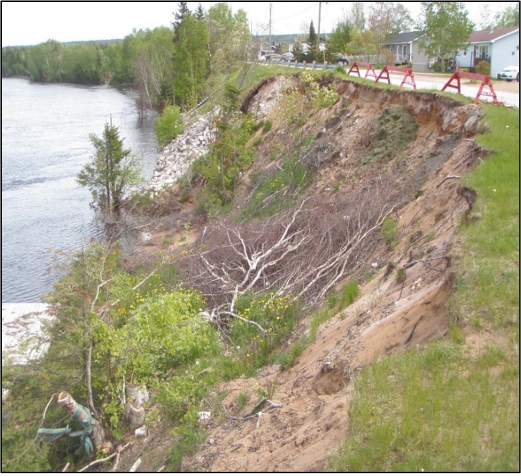
3.2 Streambank stabilization
Streambanks are composed of a variety of materials (such as sand, soil and gravel) that are easily erodible when exposed or disturbed by construction activities (Figure 3.13). Streambank erosion can result in the deposition of large amounts of sediment into the freshwater environment. Sedimentation can have a variety of negative effects on fish and fish habitat, such as damaging fish gills, smothering eggs and infilling important spawning habitat. Streambank stability is maintained in a natural state by the living network of roots and vegetation. Disturbed areas require additional stabilization measures to ensure that bank slopes are stable and resist erosion.
In general, efforts to stabilize streambanks should consider the following, with the intent of reducing erosion and the release of sediment into fish habitat:
- Stabilize or rebuild disrupted streambanks as quickly as possible after disturbance. Shape streambanks so that the bank slope is stable and conforms to the existing topography
- Streambank stabilization should not result in a decrease in the cross-sectional width of streams
- Stabilization techniques that have been proven effective in the local area should be used where appropriate
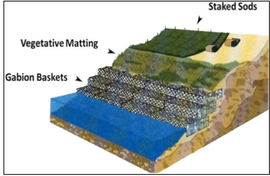
- To protect against the potential impacts of sedimentation resulting from a disturbed streambank, stabilization techniques should be used in combination with erosion/sedimentation control measures (Figure 3.14)
Sections 3.2.1 through 3.2.3 provide information on streambank stabilization (i.e. riprap, gabions, geotextile and timber cribwork). When using manufactured stabilization materials, manufacturer’s specifications should also be consulted. Further, some erosion control measures (e.g. matting) also provide stabilization.
3.2.1 Riprap
Riprap can be utilized to stabilize eroding streambanks. Riprap should only be used when vegetation cannot provide adequate bank support. The type of riprap used depends on the individual situation and the availability of materials (Figure 3.15).
When utilizing riprap for stabilization, the following best management practices are provided:
- Rock riprap should be of a blocky, angular shape, rather than elongated or round
- Rock riprap should be comprised of a mixed gradation so that smaller stones fill the voids between the larger ones to provide compaction and stability. A layer of filter stones may be required depending upon the type of underlying soil and the size of the protective riprap
- Typical riprap stone sizes that may be used for various stream flow velocities are highlighted in Table 3.1 (Buchanan et. al.1989)
- Rock riprap should not be used for banks exceeding 3 m high and a grade of more than 2:1 (Buchanan et. al. 1989)
| Stream flow (m/sec) | Mean stone diameter (mm) |
|---|---|
| Less than 3.0 | 200 – 460 |
| 3.0 – 4.0 | 200 – 770 |
| 4.0 – 4.60 | 500 – 1220 |
3.2.2 Gabions
Gabion baskets or mats are manufactured steel wire baskets that are placed and then filled with rocks. Gabions can be used to protect stream banks from erosion and to provide retaining wall support for an unstable stream bank. Gabions should be used in accordance with manufactures design and specifications (see figure 3.14).
3.2.3 Geotextiles
Geotextile filter fabrics are used to serve as a soil stabilizer, allowing water to flow through the lining, while preventing underlying soil from being washed away. The type of geotextile material used is site-specific and takes into consideration factors such as soil type, hydraulic conditions, and construction conditions and techniques. When choosing and installing geotextiles refer to manufacturers’ specifications and seek professional advice.
3.3 Watercourse crossings
Any watercourse crossing has the potential to impact fish and fish habitat as well as alter the existing natural flow regime. Crossing structures that maintain natural watercourse bottom and hydraulic conditions (e.g. bridges, bottomless arch culverts) are preferred over structures that alter fish habitat, flow regime, and constrict watercourse width. Improperly installed crossings (i.e. culverts, bridges, etc.) can result in impeded fish passage. Machinery should:
- be operated in a manner that minimizes disturbances to the watercourse bed and banks
- arrive on site in a clean, washed condition
- be maintained free of fluid leaks
Emergency spill kits should be on site in case of fluid leaks or spills from machinery.
The preferred option for mitigation of potential adverse effects of watercourse crossings is to avoid crossings where possible. In instances where watercourse crossings are unavoidable, the following best management practices are provided:
- Plan roads so as to minimize the number of required stream crossings
- Wherever possible, use existing trails, road access points, or cut lines
- When selecting a site for a proposed watercourse crossing, examine the physical characteristics of the watercourse and associated drainage basin to identify the site that will provide the best features and conditions for the crossing
- Crossing sites should be located where the stream is straight, unobstructed and well-defined
- Where possible, crossings (roads, access points, and approaches) should be perpendicular to the watercourse or waterbody, with low and stable approach and exit stream banks. Watercourse crossing structures should be installed in advance of other road construction activities
- Crossing sites should be placed where stable stream beds and banks are present and where a minimum of scour, deposition or displacement of sediments are expected to occur. Where this is not possible, stabilize approach and exit banks with corduroy, geogrid, or other suitable materials prior to beginning works, undertakings, and activities to effectively control erosion and sediment displacement
- Crossings should be located away, and preferably downstream, from areas such as fish spawning sites. If a crossing must occur in the vicinity of sensitive fish habitat, a bridge with a high approach, rather than a culvert, should be used to limit disturbance to the channel
- Crossings should be constructed where possible effects on other existing bridges and hydraulic structures can be avoided and where it is possible to minimize the risk of damage from environmental hazards such as floods or landslides
- The type of crossing structure selected and the design of the crossing structure should consider natural site features, hydraulic conditions at the site, hydraulic performance needs and the relative amount of environmental disturbance with each type of installation
- Clear-span bridges and bottomless culverts are preferable to culverts or fording sites
- Keep approach grades to a minimum for at least 15 m on each side of a watercourse and, where necessary, construct approaches to watercourse crossings with erosion resistant materials.
- Operate machinery in a manner that minimizes disturbance
- All of the environmental considerations and mitigation efforts involved in watercourse crossings apply to watercourse crossings by all-terrain vehicles, or other such vehicles
- Avoid tree/shrub removal whenever possible
- Prune or top the vegetation instead of grubbing/uprooting whenever possible
- Limit grubbing on watercourse banks to the area required for the footprint of the works, undertakings and activities
- If necessary, remove vegetation or species selectively and in phases
- Avoid stockpiling of material on stream banks and riparian zones
- Use only clean materials (e.g., rock, coarse gravel, wood, steel, snow) for works, undertakings and activities
- Restore stream banks and riparian vegetation affected by the works, undertakings and activities to their natural state (substrate granularity, profile, vegetation, etc.). Re-vegetate the disturbed banks and adjacent areas with native species suitable for the site
- Develop and immediately implement a response plan to prevent deleterious substances from entering a waterbody
With respect to protecting fish and fish habitat, watercourse crossings should abide the following conditions:
- Plan works, undertakings and activities to respect timing windows
- Limit the duration of in-water works, undertakings and activities so they do not diminish the ability of fish to carry out one or more of their life processes (e.g., spawning, rearing, feeding, migrating)
- Maintain an appropriate depth and flow, as well as maintain fish passage during all phases of works, undertakings, and activities
- Avoid disturbing or removing aquatic vegetation, natural wood debris, rocks, sand, or other materials from the banks, shoreline or bed of the waterbody
Sections 3.3.1 through 3.3.5 present specific information related to types of watercourse crossings (i.e. temporary crossings, bridges, culverts, underground watercourse crossings, and causeways; see Figure 3.16).
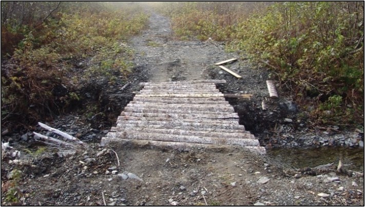


3.3.1 Temporary crossings
Under certain circumstances, properly designed temporary crossings may be used as watercourse crossings. These may include temporary clear span bridges (including Bailey bridges or log stringer bridges), fording, and temporary winter crossings (i.e., ice bridges and snow fills).
Temporary crossings are intended for short-term access across a watercourse when an existing crossing is not available or practical to use. They are not intended for prolonged use (e.g., forest or mining haul roads). Temporary clear span bridges and fording should be restricted to locations where the channel width at the crossing does not exceed 5 meters from the ordinary high water mark to the ordinary high water mark. Do not grade stream banks or approaches. Where possible, use methods to prevent substrate compaction (e.g., swamp mats, pads).
3.3.1.1 Temporary clear span bridges
The use of temporary bridges (see Figure 3.16(a)), or dry fording, is preferred over fording in flowing water as this lowers the risks of fish injury and mortality, damages to the bed and banks of the watercourse, and sedimentation of downstream fish habitat.
When using temporary bridges, the following best management practices are provided:
- Installation of a temporary bridge does not include pile driving
- The temporary bridge is no greater than one lane wide with no part of the structure placed within the wetted portion of the watercourse
- The work does not include the placement of abutments, footings or armouring (e.g., rock and concrete) below the ordinary high water mark
- Design temporary bridges to accommodate any expected high flows of the watercourse during the construction period
- Design the bridge so that storm water runoff from the bridge deck, side slopes and approaches directly runoff into a retention pond or vegetated area to prevent sediment and other deleterious substances from entering the watercourse
- Remove bridge crossing prior to the spring freshet, unless the crossing has been constructed above the annual spring high water level
3.3.1.2 Fording
Fording can occur through flowing water or in the dry (e.g., seasonally dried streambed). The use of a fording site is usually limited to periods when low flow conditions prevail and the number of crossings at the fording site is restricted. Fording must be kept to a minimum, particularly with machinery, and if repeated fording at one site is anticipated then the use of temporary bridges or permanent crossing structures is required (Scruton et. al. 1997). The appropriateness of fording may depend upon the type of vehicle using the site. While vehicles with low pressure tires may ford a stream with little disruption, tracked machinery may result in considerable environmental damage and as such may not be generally suited for fording watercourses (Figure 3.16(b)).
When fording, the following best management practices are provided:
- Fording consists of a one-time crossing (over and back) in flowing waters, or a seasonally dry streambed ford
- Avoid fording across potential spawning areas
- Fording sites should be selected on a site-specific basis after a survey of the stream. Where possible, fording should be scheduled to avoid potential adverse impacts on spawning activities, spawning habitat, egg incubation, and fish migration
- Fording sites should be situated where streambanks are stable and where approaches to the crossing have low slopes. Steep or unstable slopes should be stabilized to prevent erosion
- Fording sites should be situated in areas of instream bedrock outcrop, or stable streambed substrate
- Approaches to the fording site should be stabilized using non-erodible materials such as corduroy, brush mats, or clean stone materials
- Cross during low flow conditions, and avoid areas where the water depth will submerge any axle or differential vents. Do not skid or drag anything across the ford site
- Do not manipulate material in the wetted portion of the watercourse while fording
- Fording sites should be monitored to ensure that approaches to the site are not eroding and substrate is not being disturbed to the extent that obstructions to fish passage are created
- When a fording site is no longer required, the stream channel and banks should be restored to its natural state. Any wheel ruts or other damage that may cause sedimentation in the stream should also be repaired
3.3.1.3 Winter crossings
Winter crossings, such as ice bridges and snow fills, provide cost-effective access to remote areas when rivers and streams are frozen. Since the ground is frozen, these can be built with minimal disturbance to the bed and banks of the watercourse.
Winter crossing can be utilized when:
- Snow fills are constructed of clean snow, and will not restrict water flow at any time
- Snow fills will not result in erosion and sedimentation of the stream or alteration (e.g., compaction or rutting) of the bed and bank substrates
- Materials such as gravel, rock and loose woody materials are not used in the construction of ice bridges
When using winter crossings, the following best management practices are provided:
- Construct ice bridges on large watercourses that have sufficient stream flow and water depth to prevent the ice bridge from coming into contact with the stream bed or restricting the water movement beneath the ice
- Use only clean water, ice or snow to construct winter crossings
- Construct approaches using clean compacted snow and ice to a sufficient depth to protect the banks of the watercourse
- Do not exceed 10% of the instantaneous flow if withdrawing any water, in order to maintain existing fish habitat and flow under the ice
- Screen intake pipes to prevent entrainment or impingement of fish
- If logs are used to stabilize the approaches of an ice bridge or snow fill, do not leave logs or woody debris within the waterbody or on the banks or shoreline where they can wash back into the waterbody, and ensure the logs are clean and securely bound together so they can be easily removed either before or immediately following spring freshet
- Maintain natural, under ice water flow where it occurs
- Place notch in center of the ice bridge to encourage proper melting and reduce flooding, to ensure that fish passage is maintained
- Remove compacted snow from the snow fills prior to the spring freshet
Before beginning any work, undertakings and activities involving the use of temporary crossings, consult the temporary stream crossings code of practice located on the Projects Near Water website. A notification form should be submitted to your regional DFO office prior to the start of your works, undertakings and activities.
3.3.2 Bridges
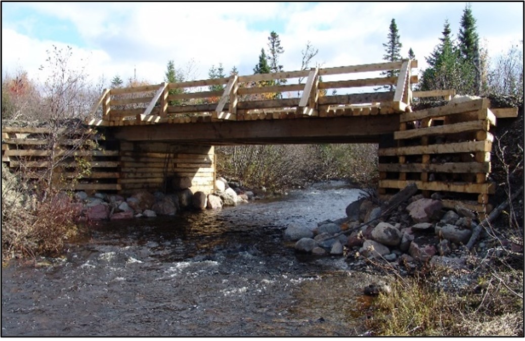
Bridges are the preferred structure for all crossings, for areas where ice blockage or rapid runoff may cause the structural failure of a culverted crossing, as well as for any watercourses that support anadromous (sea-run) and/or resident fish populations. A well-designed bridge allows for a natural stream bottom at a crossing site and should not result in any increased water velocities that may impede fish passage or cause stream bed scour (Figure 3.17).

When utilizing bridges for watercourse crossings, the following best management practices are provided:
- Bridges should be located on straight sections of a stream, where the stream channel is narrow, having low banks and firm, non-erodible soils
- Design the bridge so that storm water runoff from the bridge deck, side slopes and approaches directly run off into a retention pond or vegetated area to prevent sediment and other deleterious substances from entering the watercourse
- Concrete aprons under bridges are not recommended since fish passage can be impeded at low flows
- Bridge abutments should be located outside the wetted perimeter of the stream
- Instream piers should be aligned with the stream flow; where necessary, streambank protection should be provided
- When necessary add suitable wing-walls to prevent bank erosion
- Instream work (i.e. abutment footing construction) should be scheduled to avoid potential adverse impacts on spawning activities, spawning habitat, egg incubation, and fish migration
- Complete all instream work in the dry by either diverting or pumping water around the work site and back to the main channel immediately below the work site, such that there is no reduction in water flow and no measurable change in the downstream natural flow regime
- Any required fill should be free of fines and deleterious substances and not be taken from stream beds, banks or riparian areas
- Where it becomes necessary to demolish or remove a bridge, every effort should be made to avoid “dropping the bridge” into rivers/streams. This could be done by “sawing” appropriate sections of the bridge and using cranes to lift these sections or by constructing a platform onto which the bridge could be dropped. Disturbed areas should be stabilized to prevent erosion
- If the stream channel bed passing through the proposed bridge crossing is altered or disturbed, it should be reconstructed to a shape, profile, and substrate composition that is conducive to good, productive fish habitat for local species. Ensure fish passage past the bridge site is as good as pre-bridge conditions
- Fish passage should be maintained past the bridge site during all phases of construction and post-construction
- Implement measures to avoid site erosion and sediment release to receiving waters during phases of project execution and post completion
3.3.3 Culverts
Culverts are the most commonly used method for providing access over a watercourse, and particularly for small and medium sized streams. Several types of culverts are used including open bottom/bottomless arch, pipe arch, box, and circular/cylindrical. Box type culverts are generally made from wood or concrete while other types are made from plastic, concrete or, most commonly, corrugated metal. Figure 3.18 illustrates some culvert crossing related terms used in this document and Figure 3.19 identifies culvert shapes.
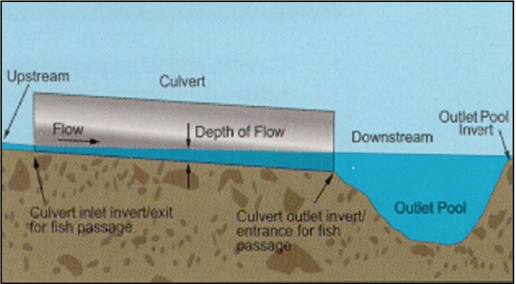
Text version: Figure 3.18 Illustration of general culvert terms
Culvert terms:
- upstream
- downstream
- culvert
- culvert inlet invert/exit for fish passage
- culvert outlet invert/entrance for fish passage
- flow
- depth of flow
- outlet pool
- outlet pool invert
The following best management practices concerning culvert installations and maintenance/repair is generic and has been developed to apply to a variety of different circumstances. In some site-specific situations a professional engineer and/or biologist should be consulted. Where fish passage is required, sufficient water depth and appropriate flow velocities must be provided for the fish species and size of fish at the site/area.
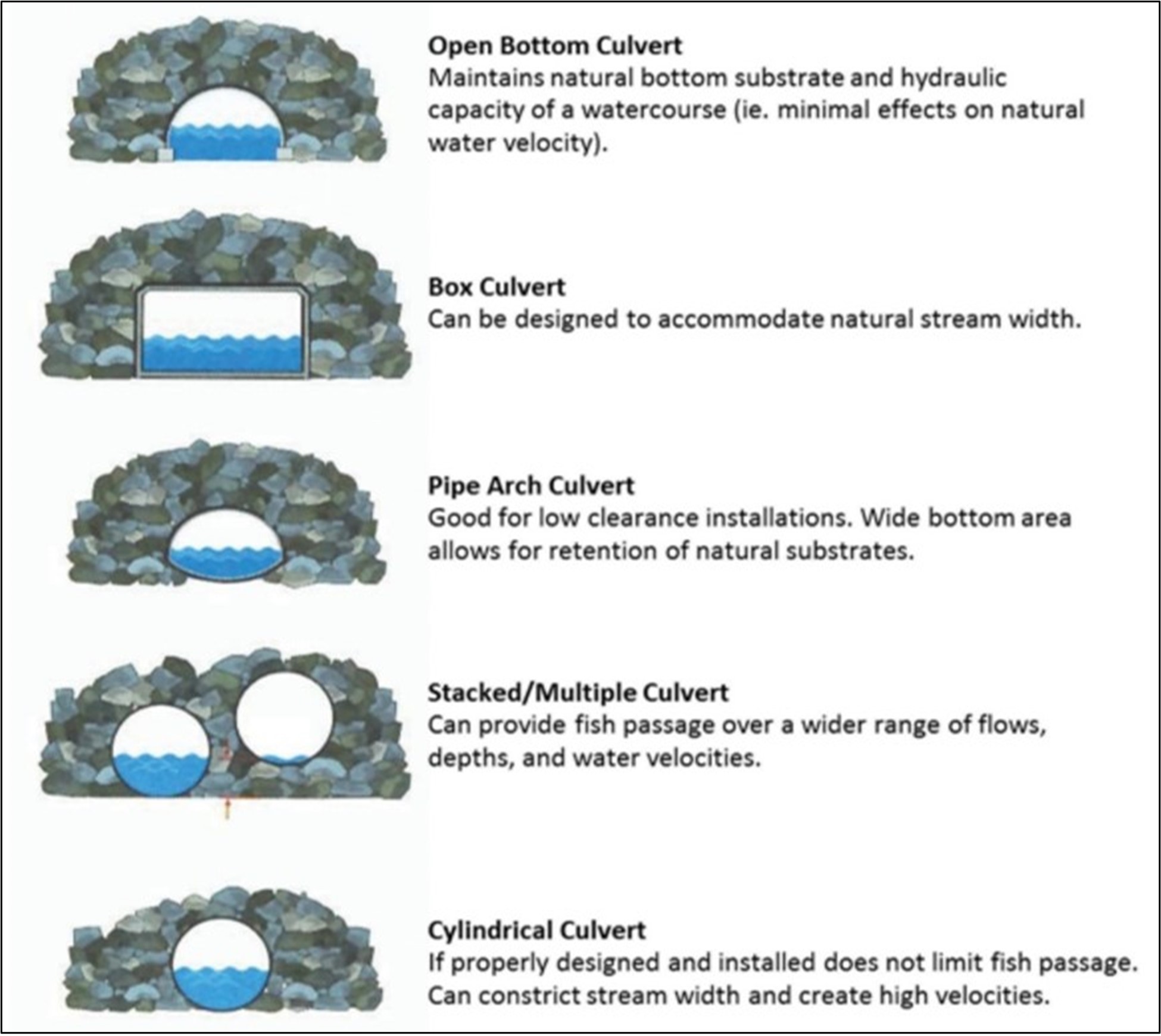
Text version: Figure 3.19 Culvert shapes
- Open bottom culvert
- Maintains natural bottom substrate and hydraulic capacity of a watercourse (ie. Minimal effects on natural water velocity).
- Box culvert
- Can be designed to accommodate natural stream width.
- Pipe arch culvert
- Good for low clearance installations. Wide bottom area allows for retention of natural substrates.
- Stacked/multiple culvert
- Can provide fish passage over a wider range of flows, depths, and water velocities.
- Cylindrical culvert
- If properly designed and installed does not limit fish passage. Can constrict stream width and create high velocities.
3.3.3.1 Culvert installation
When installing culverts, consider these best management practices:
- Improperly selected and sized culverts can become obstructions to fish migration and can cause upstream flooding. Culvert size should be based on the capacity to handle peak flows. It may be necessary to have a hydrologic and hydraulic analysis performed in order to determine the correct size culvert to be used. The hydrologic analysis is used to determine the peak flow and the hydraulic analysis is used to calculate the capacity of the culvert to adequately pass the peak flows
- Selection of the type of culvert should consider site-specific characteristics such as:
- cross-section of watercourse at the crossing site (e.g. wide and shallow, narrow and deep, etc.)
- fish habitat characteristics/substrate types (e.g. spawning habitat, boulders, gravels, etc.)
- hydrologic factors (e.g. flashy system, low flows and high flows, ice conditions, etc.)
- The type of culvert selected and installed should minimize potential impacts on fish habitat, maintain fish passage, and sufficiently accommodate watercourse flows. To the extent possible, natural stream conditions (i.e. widths, habitat, etc.) should be maintained
- Open bottom/bottomless arch culverts are the preferred type of culvert installation. These culverts maintain the natural bottom substrate and hydraulic capacity of the watercourse when footings are installed outside the wetted perimeter of the stream
- Footings for open bottom culverts should be installed outside the normal wetted perimeter of the watercourse and tied into the bedrock or sufficiently stabilized to prevent erosion around the footing or undermining
- Pipe arch culverts often maintain the hydraulic capacity of the natural channel and are preferred over cylindrical culverts. Cylindrical culverts usually reduce the cross-sectional area of water entering the culvert which may result in:
- an increase in water velocity which may make it difficult for upstream migration of fish
- undermining at the culvert inlet or streambed scouring at the culvert outlet
- an area where free flow of debris may be restricted which results in obstructing fish migration as well as flooding of upstream areas
- To allow fish passage, cylindrical culverts should have a minimum diameter of 1000 mm and be designed/sized according to site-specific features, including hydrologic/hydraulic considerations
- Cylindrical culverts should be installed to simulate open bottom or pipe arch culverts. Culverts up to 2000 mm in diameter should be countersunk a depth of 300 mm below the streambed elevation. Culverts having a diameter equal to or exceeding 2000 mm should be countersunk a minimum of 15% of the diameter below the streambed elevation (Figure 3.20)
Figure 3.20 Countersunk culvert 
- Countersinking reduces the hydraulic capacity of the culvert, therefore, the required diameter of the culvert must be adjusted for countersinking
- Install culverts in alignment with the existing natural channel and located on a straight stream section of uniform gradient
- The culvert should be placed on firm ground and be countersunk to the appropriate depth. In sites where a soft foundation is present it should be removed and replaced by clean granular material to prevent the culvert from sagging. Water movement under or around a culvert installation should be prevented through the use of headwalls, or other means, as necessary
- A culvert should extend beyond the upstream and downstream toe of the fill (e.g., a minimum of 300 mm)
- For multiple culvert installations, the culvert intended to provide fish passage should be placed in the deepest part of the channel and be countersunk to the required depth. The remaining culvert(s) should be placed 300 mm above the invert of the fish passage culvert (Figure 3.21)
Figure 3.21 Multiple culvert installation 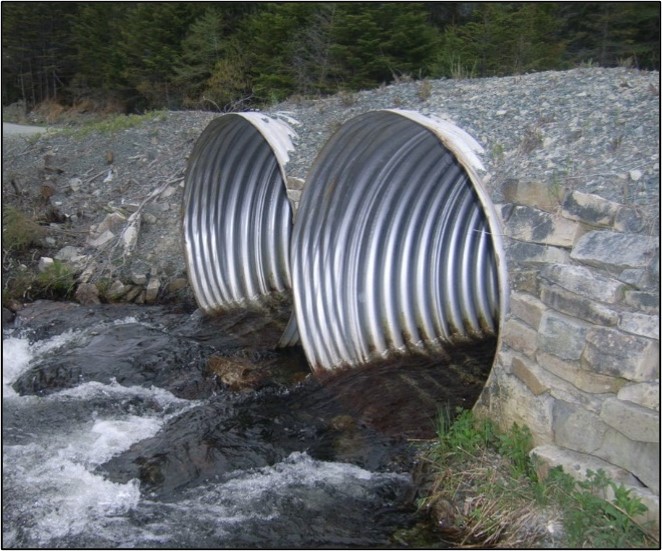
- For stacked/multiple culverts, pools should be installed with the fish passage culvert orientated to the center of the pool to allow for a smooth transition of water from the culvert to the watercourse
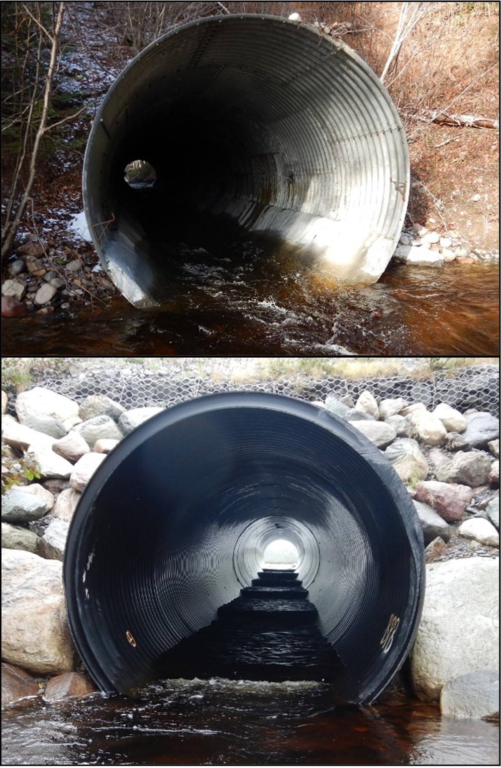
- Culverts should be sufficiently sized and installed such that scouring of the outlet streambed does not occur as a result of increased water velocities in the culvert. Elevated culvert outlets may result in streambed scouring and can become an obstruction for migrating fish as illustrated in Figure 3.22
Figure 3.22 Perched entrance and properly installed culvert entrance 
- A minimum water depth of 200 mm should be provided throughout the culvert length. To maintain this water depth at low flow periods a downstream pool can be constructed. A downstream pool is of particular importance for long culverts or culverts to be installed on steep slopes. In some cases, an upstream pool may also be necessar
- The invert of the pool outlet should be at an elevation that maintains a minimum of 200 mm of water depth up to the inlet or upstream end of the culvert (Figure 3.23)
Figure 3.23 Culvert installation showing downstream pool to maintain minimum 200 mm water elevation throughout culvert 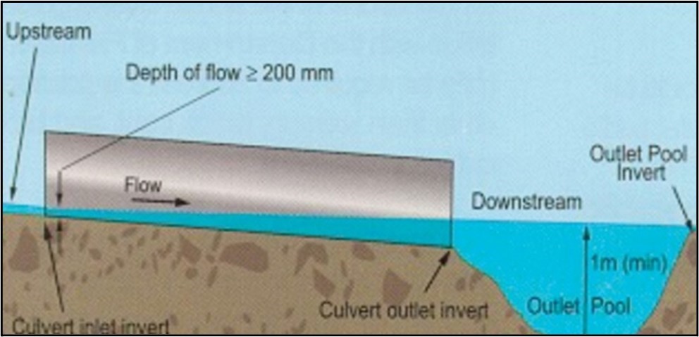
- The culvert slope should follow the existing stream gradient slope where possible. Increasing culvert slope, reduced culvert capacity due to countersinking and maintenance of the 200 mm minimum depth of flow, and back watering due to the creation of an outlet pool should be considered when selecting the required culvert diameter to meet fish passage and hydraulic criteria such as passing peak flows
- Pools should be pear shaped and sized such that: pool length is 2 to 4 times the fish passage culvert diameter; pool width is 2 to 3 times the fish passage culvert diameter; and pool depth equals 0.5 times the fish passage culvert diameter with a 1 m minimum. (Figure 3.24)
Figure 3.24 Recommended pool dimensions 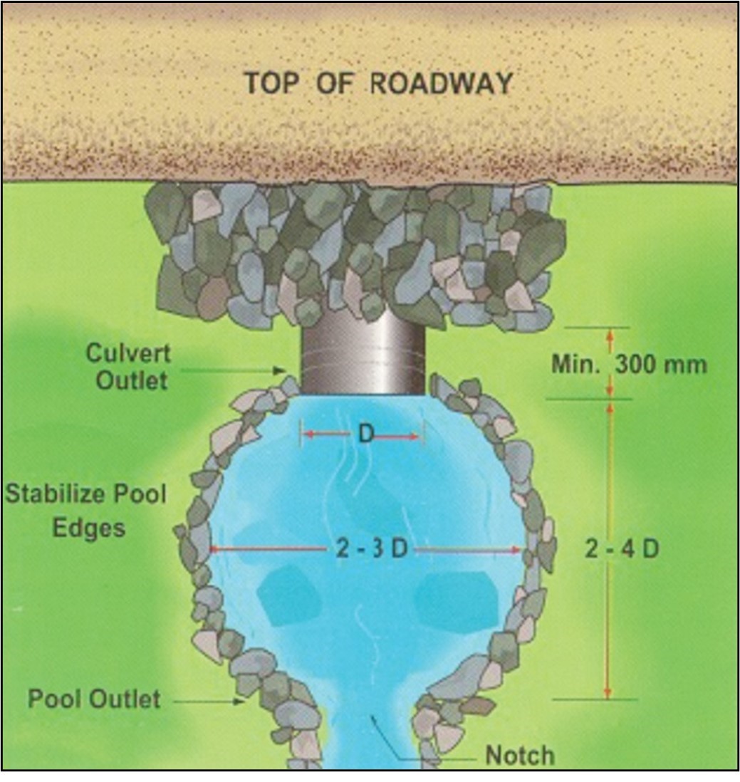
- Pools should be designed so there is a smooth transition of flow from the culvert to the natural stream width
- The natural streambed elevation should be used as the pool outlet invert; however, depending on site-specific conditions, a pool outlet may need to be constructed. It is essential that the invert elevation of the pool outlet be stable and, if necessary, well-maintained to ensure a minimum water level in the culvert. Clean, non-erodible riprap or gabions should be used to stabilize the pool edges. If a pool outlet is constructed, care should be taken not to introduce blockage to fish passage. For example, the pool outlet may need to be v-notched to enable fish passage at low flow periods. Depending on site-specific features (e.g. gradient) more than one pool may be required
- Depending on site-specific conditions (e.g. steep slopes, long crossings, constricted streams resulting in high water velocities, etc.), baffles/weirs may need to be installed in the fish passage culvert (Figure 3.25). Baffles/weirs can provide an adequate depth of flow and reduce the water velocity in the culvert in order to facilitate fish passage. Baffle dimensions are provided as per Figure 3.26
Figure 3.25 Culvert baffles 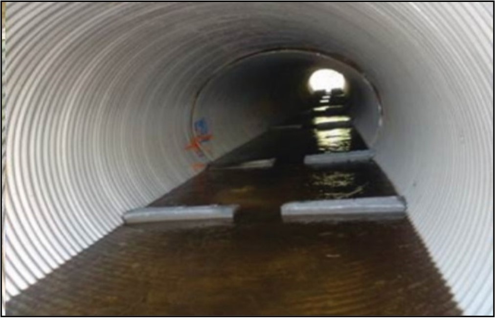
Figure 3.26 Baffle sizing 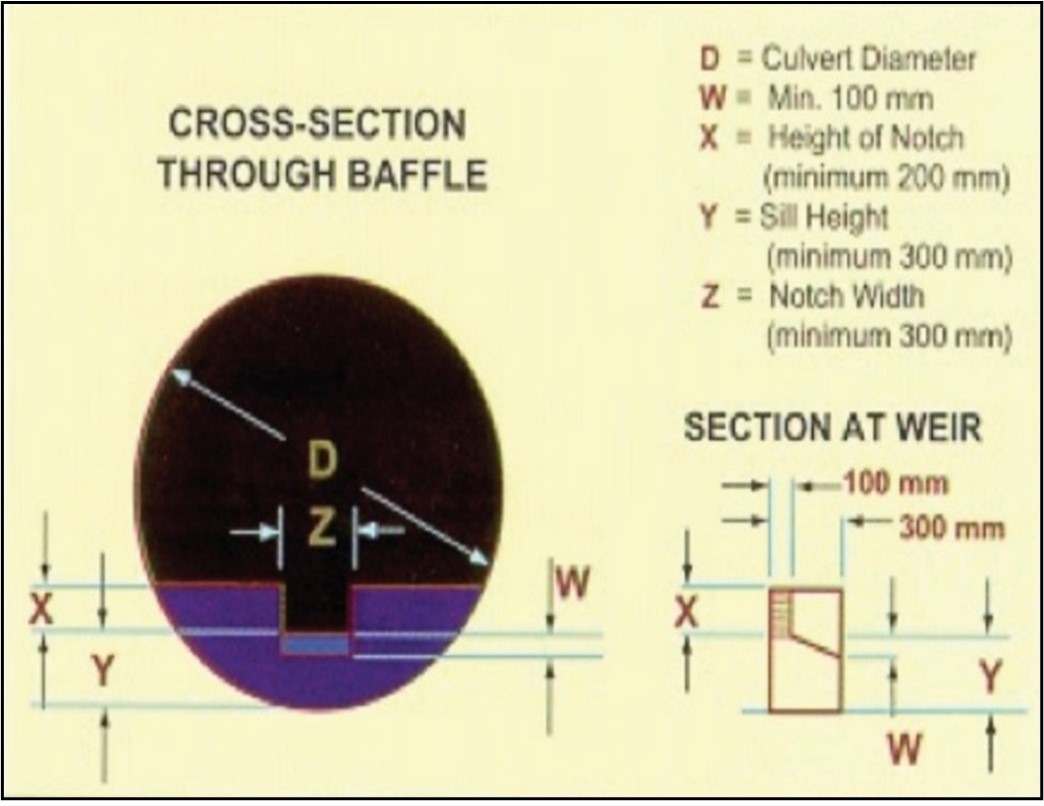
Text version: Figure 3.26 Baffle sizing
Cross-section through baffle and section at weir
D = Culvert diameter (mm)
W = minimum depth of water over the sill, at least 100 mm
X = Height of notch (of the baffle), minimum 200 mm
Y = Sill height, minimum 300 mm, from bottom of culvert/baffle to top of the sill
Z = Notch width, minimum 300 mm - A minimum depth of flow of 200 mm should be provided throughout the culvert and baffled sections. The drops between adjacent baffles should be a maximum of 200 mm
- Baffles should be placed approximately 1 m from the inlet and outlet ends of the culvert, the next baffles should be placed at 1/2 the baffle spacing. Baffle size and spacing should be determined by using the low flow (flow at the time of fish migration, i.e. lesser of flow at 90% exceedance via flow duration analysis or 7 day, 10 year low flow) as a basis for meeting the above depth of flow and drop between baffles criteria. Baffle spacing should also provide a pool volume between baffles large enough to dissipate the kinetic energy produced by the water falling over the weir; and consider high flows (i.e. 10% exceedance based on flow duration) during the fish migration period. Baffle spacing is presented in Figure 3.27
Figure 3.27 Culvert baffle spacing requirements 
- The baffle culvert should be installed such that the invert elevation of the outlet pool backs water up to the top of the outlet baffle (i.e. entrance baffle); that is, set the elevation of the top of the entrance baffle to be the same as that of the pool outlet invert elevation. Baffled culverts should be countersunk approximately 100 mm below the streambed elevation. If countersinking exceeds 100 mm then the baffle system arrangement/design may need to be adjusted accordingly
- Culvert installations should be suitably stabilized to prevent erosion, seepage, and undermining, and maintained in good operating condition. Headwalls, and where site conditions permit, wingwalls, or other appropriate means should be installed to ensure that all water is directed through the culvert system
3.3.3.2 Culvert maintenance / repair
Culvert lining is the re-enforcing of a culvert required because of a failure of the integrity of the structure, often times as a result of corrosion or physical damage. This would include replacing the bottom of corroded steel culverts with concrete or other material, or inserting sleeves/liners (e.g., High-Density Polyethylene (HDPE) liners) inside weakened or deformed culverts (Figure 3.28). Ideally damaged culverts should be entirely replaced with new corrugated culverts, however in some scenarios liners and inverts are less costly and require less upheaval of the surrounding area and can effectively extend the life of a culvert. Due to the nature of the installation of both culvert liners and concrete inverts this work will be done in the dry, with the watercourse diverted in some way or pumped around. The use of liners and inverts should still follow all of the aforementioned best management practices for culvert installation such as water depth, velocity, stream gradient, etc.
When conducting maintenance or repairs on culverts, consider these best management practices:
- The use of liners will reduce the diameter of the culvert and as a result increase the velocity of the water. Depending on the material used, liners may also have a smoother surface than a corrugated culvert which can also increase velocity of the waterbody. To minimize the impacts of this to fish passage, baffles should be added to ensure adequate water depth and create low velocity zones. Water velocities 20 cm/s and above may begin to interfere with the migration of juvenile trout
- Culvert liners can be applied through a variety of methods and materials, regardless the new liner should have a water tight seal with the old culvert so as to prevent erosion, seepage and undermining
- When installing concrete inverts it is important to still maintain the stream gradient between the inlet and outlet ends of the culvert. In order to mitigate interruptions in fish passage during low flow periods it is also suggested that a V notch be placed in the middle of the concrete invert in order to maintain flow and hydraulic connectivity
- Following the installation of cast-in-place concrete, all fresh concrete must be allowed to dry and cure properly, which may require up to 48 hours. It must be installed with tight joints in order to prevent leakage. Fresh or uncured concrete should not come into contact with the waterbody, therefore equipment and tools that were used must not be washed in any body of water or stream
- When liners or inverts are employed to extend the life of a culvert, inspections and maintenance should be done regularly to ensure they are performing as expected
Note: Modifications of the above criteria in consultation with Fisheries and Oceans Canada (DFO) may be required to address the passage of fish species other than salmon, brook trout, and brown trout in culvert installations. Further, site-specific considerations may warrant modification of the above guidance, as deemed appropriate and in consultation with the department. Detailed guidelines for culvert maintenance can be found in the culvert maintenance code of practice on the Projects Near Water website.
3.3.4 Underground watercourse crossings
Project developments sometimes require that streams be crossed by water pipes, sanitary sewers, underground cables, etc. The number of crossings should be minimized. Necessary crossings should follow roads, thereby reducing the overall impact on the stream. Construction of underground facilities results in disturbance to the stream bed and may produce downstream sedimentation. Improperly constructed underground crossings can also result in “piping”, reducing and in extreme cases stopping stream flow below the crossing site.
When undertaking developments beneath the streambed, the following best management practices are provided:
- Instream works associated with underground stream crossings should be carried out in the dry
- Where possible use trenchless methods, such as directional drilling, to construct underground crossings
- Once the pipe installation has been completed, the trench created in the stream bed should be partially filled with suitable materials; these materials can then be compacted and the stream bed brought back to its previous elevation and grade using a topping of clean, non-erodible materials containing a minimum of fines (Figure 3.29)
- The materials used for the “topping” in the crossing area should be consistent with the material substrate of the stream in this area and should be large enough to resist displacement by peak flows
- Once the stream crossing has been properly completed and the crossing area sufficiently stabilized, regular maintenance is usually not required unless site-specific problems arise; any subsequent requirements for excavation should be carried out as described above
- Streambanks and approaches to or from crossing areas disturbed as a result of underground crossing construction activities should be stabilized immediately after the crossing has been completed
- Excess materials resulting from stream bed/streambank excavation should be disposed of or stockpiled so as to prevent entry into any watercourse

3.3.5 Timber cribwork
Timber cribs are used as erosion control/stabilization structures as well as being part of wharf or dock structures and bridge abutments. When utilizing timber cribwork, the following best management practices are provided:
- Material used to fill a submerged timber crib structure should be free of fines or sediment; suitable materials may include clean blasted rock or boulders (Figure 3.30)
- Material should never be removed directly from any watercourse, from any shoreline, or from any streambank area for use as ballast
- Shoreline or streambank disturbance should be restricted to the immediate work area. Disturbed shorelines or streambanks should be stabilized
- Untreated wood or pressure treated wood is recommended for use in or near freshwater environments (Figure 3.31). Manually applied wood treatments may also be used. Freshly-treated preserved wood should be avoided. The appropriate regulatory agency (Environment and Climate Change Canada) should be contacted regarding the use of wood treatment products, weathering, and the location of treatment sites for manually applied preservatives
- Regular maintenance should be carried out on timber cribs to prevent collapsing and possible shifting of the crib or ballast. Any timber crib material moved by ice or wave action should be recovered

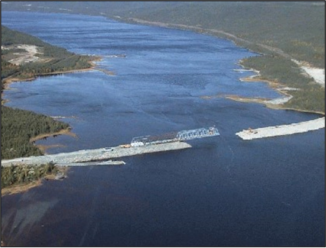
3.3.6 Causeways
A causeway for linear development should only be constructed when alternate routes prove to be unfeasible. If causeway installation is necessary, the causeway should cross the shortest possible length of the waterbody or wetland area and provide for fish passage (Figure 3.32).
When constructing a causeway, the following guidance is provided:
- Avoid infilling small wetland areas
- Avoid causeway construction at the peak of fish migration and schedule construction so as not to interfere with sensitive periods of aquatic species life cycles
- Structures required for the maintenance of fish passage and flow of water (e.g. culverts) should be installed during, rather than after, causeway construction. This will eliminate the need for future construction activities in the area
- Design causeways and associated culverts and/or bridges to permit fish passage over the full range of natural flows. Causeway openings should have sufficient clearance to handle peak flows without interference to fish movement
- Causeways should be built in areas with a solid, stable bottom to prevent shifting of bottom substrate and subsequent lifting of the watercourse bottom in areas adjacent to the causeway
- Equipment should only be operated from dry, stable areas, such as the advancing causeway fill material
- Causeway construction materials should consist of clean granular fill material, boulders, blasted rock, and armour stone
- Protect causeway embankments against erosion due to waves, ice and currents through the placement of suitably sized armour stone and riprap
3.4 Site preparation, buffer zones, decommissioning and rehabilitation
Site preparation activities, such as clearing and grubbing, can release sediment into nearby watercourses, resulting in damage to fish and fish habitat. Much of the impact of site preparation activities can be reduced or eliminated by a preliminary site visit and adequate planning that considers the development of an erosion control program. Effective mitigations such as buffer zones should always be considered prior to the preparation of project sites, since these areas provide considerable protection to adjacent watercourses from the impacts of nearby activities. Consideration should be given to the provision of long-term erosion protection for all aspects of site rehabilitation including the proper removal of roads, ditches and stream crossing structures. General considerations for site preparation, buffer zones and abandonment are:
- Site reconnaissance should be undertaken early in project planning stages to identify the location of watercourses and fish and fish habitat in relation to the proposed development
- The lifecycle of the entire project, from site preparation to abandonment should be considered during the planning stage to ensure impacts are minimized during each stage of the project
- The activities to be carried out at the site should be identified in the project planning stages to ensure that adequate buffer zones are maintained between watercourses and the development site
- Abandonment plans should be considered early in the project development. Planning of abandonment activities in these early development stages will ensure that the abandoned site is returned as closely as possible to predevelopment conditions
Sections 3.4.1 through 3.4.4 provide detailed information on site preparation, buffer zones and abandonment
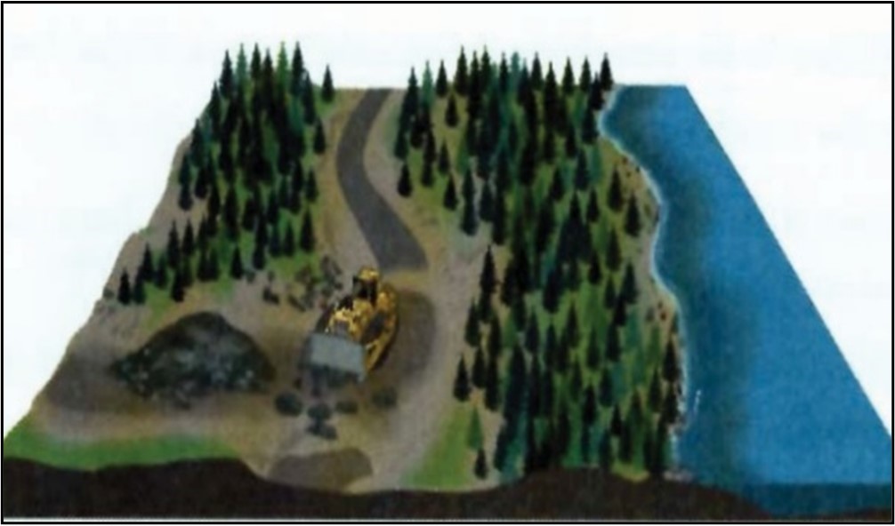
3.4.1 Stockpiling
Material stripped from a construction site during site preparation is often stockpiled. Stripping involves the removal of topsoil and overburden before the construction of an access road or facilities. Topsoil and organic material are often kept at the construction site for use in revegetation following the completion of construction activities. Stockpiled overburden material is often removed from the site and should be disposed of at a landfill approved by the appropriate regulatory agencies.
Best management practices for stockpiling are provided below:
- All stockpiles should be easily accessible, located on well-drained ground, and separated from watercourses by a minimum distance of 50 m
- Runoff from stockpiles should be intercepted by properly located interception ditches and directed to suitably sized interception ponds (See Best Management Practices on sedimentation)
- A working space of at least 5 m around stockpiles is recommended
- Topsoil and organic material should be stored in low (e.g. 1 to 2 m high) stable piles to decrease compaction effects. When stored for extended periods, these materials should be vegetated to minimize nutrient loss and erosion of fines
3.4.2 Buffer zones
Buffer zones should be maintained along watercourses for erosion protection (Figures 3.33 and 3.34). The width of the buffer will depend on soil characteristics, the steepness of the slope leading to bodies of water, the type and quality of habitat being protected, and the type of activity being buffered. Table 3.2 outlines recommended buffer zone widths for a variety of activities when carried out near water bodies. Larger buffers also exist around protected public water supply areas (PPWSA; see Table 3.3).

For specific details regarding buffer zones with respect to various industry operations, please consult reference material accompanying Table 3.2.
Despite differences in the design criteria, buffer zones generally function to:
- Protect riparian vegetation to provide shading, bank stability, food supply for fish, etc
- Protect water quality by acting as a sediment trap between the watercourse and an area of significant land disturbance
- Stop the erosion of soils and dampen the impacts of excessive rainwater runoff and snow melt upon watercourses (reduces peak runoffs to watercourses, thereby decreasing instream erosion)
| Activity | Recommended buffer associated reference |
|---|---|
| Urban development | 15 md |
| Recreational cottage lot development | 30 me |
| Land disturbance (i.e., timber cutting, silviculture, roads, skid trails, landings, clearing of vegetation, etc) | 20 ma, b, c1, f |
| 20 m + 1.5 x slope (if slope > 30 %)a, b, c1, f | |
| 30 mb to 50 mf (near scheduled salmon rivers) | |
| Grubbing | 30 ma, b, c1 |
| Piling | 30 mc1 |
| Reservoir clearing (i.e., hydroelectric) | 15 mf |
| Quarries / burrow pits | 50 ma to 100 mb, f |
| Slash / debris | 30 mc1 / above high water marka |
| Camps | 30 mc2 |
| Fuel (< 25 L); storage / handling / use | 15 mb, f |
| Fuel (< 2000 L); storage / handling | 30 mb, f |
| Bulk fuel (> 2000 L); storage / handling / use | 100 ma, b, c1, f |
| Equipment servicing / washing / refueling | 30 ma |
| Blasting | 200 mb, c1, f |
a. Forestry: Environmental Protection Guidelines for Forestry Operations in Newfoundland and Labrador; Department of Fisheries and Land Resources, 2018.
b. Linear Development: TL 267 Overland Transmission Environmental Protection Plan; Nalcor, 2016.
c1. Mining: Environmental Protection Plan Big Triangle Pond Mineral Exploration Resource Access Road and Associated Mineral Exploration Activities; Eagleridge International Limited, 2015.;
c2. Mining: Mineral Act, 2014.
d. Urban: The 1994 Development Regulations; City of St. John's, 2020.
e. Rural: Remote Recreational Cottage; Fisheries, Forestry and Agriculture webpage, 2021.
f. Hydroelectric: LITL Vegetation Protection and Environmental Effects Monitoring Plan; Nalcor, 2014.
| Protected Water Supply Area | Recommended Buffer Widths* |
|---|---|
| Intake Pond, Lake, or Reservoir | Minimum 150 m |
| River Intake (for a distance of 1 km upstream and 100 m downstream) | Minimum 150 m |
| Main River Channel | Minimum 75 m |
| Major Tributaries, Lakes or Ponds | Minimum 50 m |
| Other Waterbodies | Minimum 30 m |
*Government of Newfoundland and Labrador, 2021.
| Petroleum Products | Regulatory Requirements* |
|---|---|
| Refueling | 150 m |
| Tank storage | 500 m |
*Government of Newfoundland and Labrador, 2021.
When planning and maintaining buffer zones, the following best management practices are provided:
- The degree of protection required for a poorly defined watercourse should be determined early in the planning stage through consultation between the proponent and DFO
- If a steep or unstable bank is present on one or both sides of the watercourse, the buffer zone should be measured from the top of the bank
- Linear facilities (e.g. transmission lines, roads, pipelines, water and sewer lines) paralleling the watercourse should be outside the buffer zone, but under some circumstances the buffer zone may be utilized to access these facilities for infrequent maintenance. If facilities require frequent maintenance, an access road should be constructed outside the buffer zone
3.4.3 Right-of-way clearing and grubbing
The clearing, removal and disposal of vegetation (trees, logs and brush) is often accompanied by grubbing activities, which involve the removal and disposal of roots and stumps (Figure 3.35). These activities are common practices in many construction-related operations and are important issues to address when such developments are adjacent to a watercourse. The extent of clearing and grubbing associated with creating right-of-way widths depends upon the type of project and the vegetation cover present.

Best management practices for right-of-way clearing and grubbing are provided below:
- Keep right-of-way widths at water crossings to a minimum. Right-of-way widths at watercourse crossings should not exceed the minimum specified for that road class. Ground vegetation is essential to erosion control. For watercourse crossings a 30 m no grub zone should be maintained on the approaches to the watercourse crossing. Within this 30 m zone there should be no grubbing. This would allow the top layers of the soil/overburden and tree stumps to remain in place and filter runoff from disturbed areas prior to discharge to the watercourse (Figure 3.36)
- Right-of-way boundaries should be clearly marked prior to the commencement of clearing operations, particularly for no-grub zones (30 m on each side of a watercourse)
- Right-of-way cutting should not extend to the perimeter of watercourses; a buffer zone of undisturbed vegetation (Table 3.2) should be maintained for all activities adjacent to a watercourse
- Fell trees away from all watercourses. Leaners should be removed; slash and debris should be piled above the high water mark so that this material cannot enter watercourses during periods of peak flow
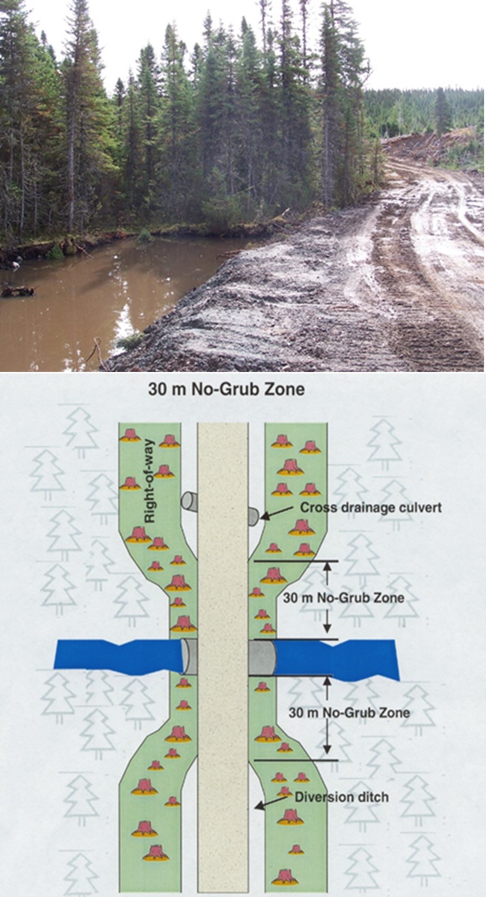
3.4.4 Site reclamation and abandonment
To ensure the protection of fish and fish habitat, site reclamation for any development activity is an issue that should be addressed during the planning stage. The following best management practices should be considered with respect to site reclamation and abandonment:
- All slopes of the site should be reduced as much as possible. Long slopes should be benched or terraced to interrupt the flow of water and minimize erosion
- Vegetative growth should be restored on all denuded areas by seeding or laying sod
- Once all decommissioning activity is completed and vegetation has been re-established, sediment traps (e.g. silt fences, filter fabric dams) and any accumulated sediment should be removed
- Ditches, settling ponds and stream diversions should be filled in and stabilized when no longer in use
- Fuel and hazardous materials should be removed from the area
- When it is determined that an access road is to be abandoned, the road surface should be scarified to promote the natural regeneration of a productive forest. Surface erosion can be controlled with ditching. These ditches intercept surface runoff and redirect runoff away from the road surface and into surrounding vegetation
- Upon road abandonment, bridges and culverts that require ongoing maintenance should be removed when the road is abandoned. Streambanks around the disturbed area should be stabilized to ensure erosion protection
3.5 Instream work in the dry
Instream work should be avoided, where possible. Potential adverse effects of improperly conducted instream work include sedimentation of downstream habitat and alteration, disruption or destruction of habitat at the work site. However, it is recognized that at times it may be necessary to perform instream work as part of a project development. Work is defined as “instream” when it is performed anywhere within the high water mark. This includes work outside the wetted perimeter of a stream during periods of low flow. Effective worksite isolation can significantly reduce unnecessary damage to fish and fish habitat. Some potential adverse impacts of improperly conducted instream work include direct damage to substrates, loss of riparian habitat, entrapment of fish in dry work areas, increased erosion and sedimentation, and obstruction of fish passage.
When conducting instream work in the dry, the following should be considered:
- Provision of fish passage should be maintained throughout the period of instream work
- Any fish entrapped in the dry work area should be removed and relocated to an appropriate area of the stream
- Plan instream works, undertakings and activities to respect timing windows to protect fish and fish habitat. Schedule work to avoid potential adverse impacts on spawning activities, egg incubation, spawning habitat and fish migration. A qualified environmental professional should be contacted regarding sensitivities concerning the habitat and habitat utilization of various fish species in the proposed work area.
- The duration of instream activities should be minimized
- Substrate and/or bank material should not be removed from the stream or streambanks
- It is preferable that instream work be carried out by heavy equipment working from dry land. Where it is necessary to have heavy equipment in waterways, such equipment should be rubber tired and free of leaks of fuel, oil and hydraulic fluids. Equipment should be steam cleaned prior to use instream. Equipment should not be serviced or washed in areas adjacent to watercourses
- Frequent inspections of any instream structures, especially during periods of high runoff, are important to determine whether repairs or modifications are necessary to reduce any environmental impacts such as erosion and sedimentation
Sections 3.5.1 through 3.5.3 provide information on specific methods of conducting instream work in the dry through the use of diversion channels or elevated piping in combination with cofferdams.
3.5.1 Cofferdams
This technique is recommended for relatively short term projects on smaller streams or during low flow periods, but can also be applied in larger rivers, ponds or lakes. Essentially, a cofferdam extends from the shore, encircles the area of the stream to be closed off and then returns to the shore. Cofferdams can be used alone to isolate work areas along stream margins from stream flow (Figure 3.37), or in conjunction with temporary diversion channels or elevated piping to create a dry work area that spans the full width of a stream (Figure 3.38). A cofferdam usually consists of a double row of sand bags with plastic between the rows. Only clean, sediment-free materials should be used as fill and all bags and materials must be removed after construction is completed.

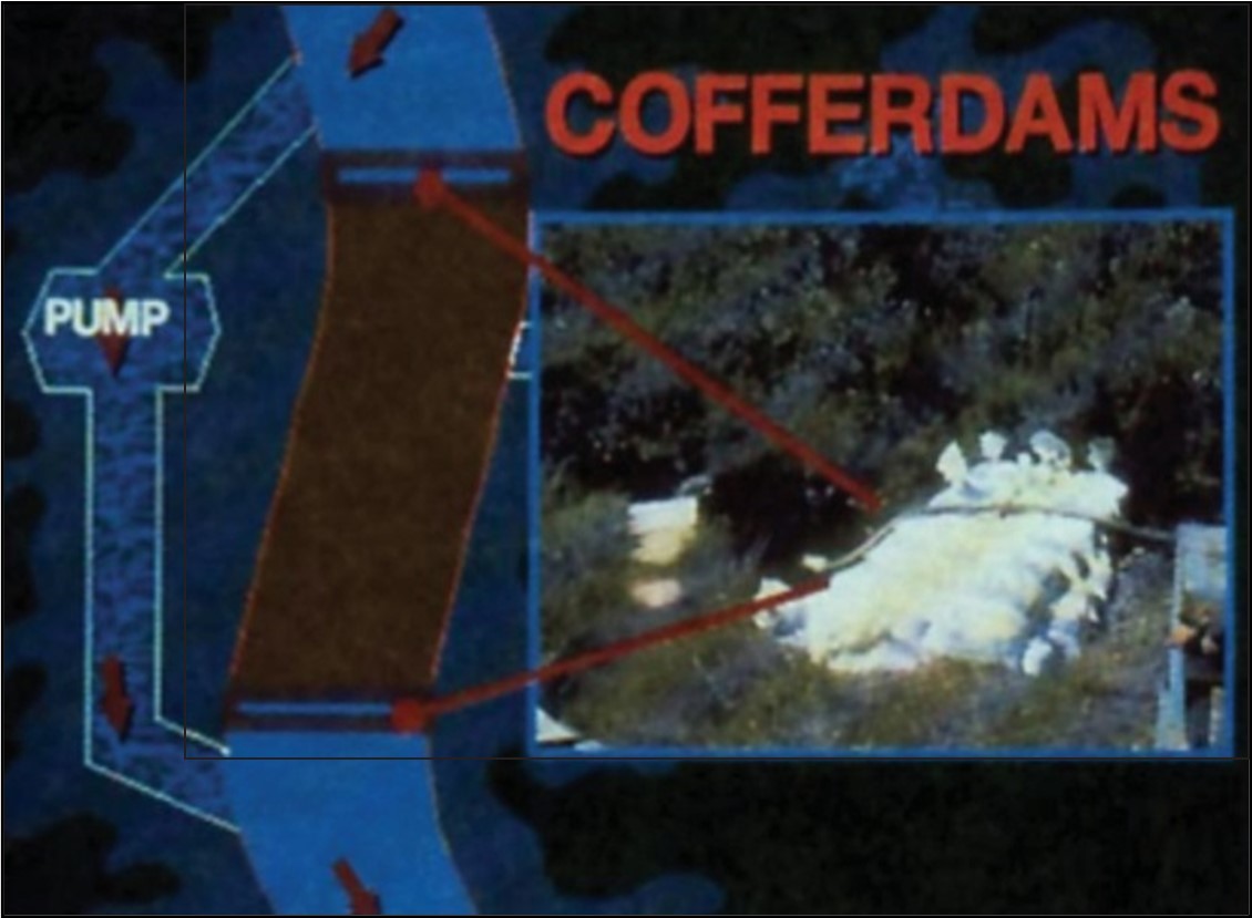
Best management practices related to cofferdams are provided below:
- Consideration should be given to maintaining fish passage and downstream flow throughout the area
- Cofferdams should be sufficiently high to prevent overtopping in the event of sudden increases in water levels
- To prevent sediment from entering the stream, a pump should be used to remove sediment-laden water from the work area inside the cofferdams. This water should be treated by discharging to settling ponds, vegetated areas or sediment traps (e.g. silt fences, filter fabric dams, etc.) prior to release to streams
- If pumps are used to route streams around cofferdams for more than one day, the pump operation should be monitored during periods when no work is occurring at worksites. Back-up pumps should be readily available on-site in case of pump failure or high flow events
- Care should be taken to seal leaks in cofferdams. Sand bags damaged during the course of work should be replaced
- When the work is complete and the area fully stabilized, the downstream cofferdam should be removed first, followed by the upstream cofferdam
- All cofferdam materials should be removed from the stream and disposed of at a landfill approved by the appropriate regulatory agency, or, if possible, reused or recycled
- For additional measures for protection of fish and fish habitat when using cofferdams, consult the temporary cofferdams and diversion channels code of practice located on the Projects Near Water website
- DFO and other regulatory agencies, as appropriate, should be advised of the installation of temporary cofferdams. A notification form should be submitted to your regional DFO office prior to the start of your works, undertakings and activities
3.5.2 Temporary diversion channel
A temporary diversion (Figure 3.39) is one method used to conduct instream work in the dry. This method is usually limited only by the availability of space within which to construct a diversion. The water is diverted into an excavated stream bypass lined with plastic and secured with crushed stone. These diversions should always be excavated in isolation from stream flow, starting from the bottom end of the diversion channel and working upstream to minimize sediment production.
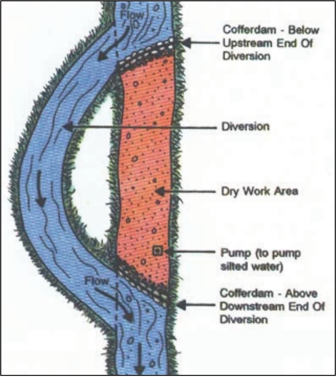
Text version: Figure 3.39 Features of a well-constructed temporary diversion
Features:
- Cofferdam – below upstream end of diversion
- Diversion
- Dry work area
- Pump (to pump silted water)
- Cofferdam – above downstream end of diversion
Stream diversions should be completed as quickly as possible, preferably within a single day during the low flow period. Upon completion of the instream work, the stream should be restored to original configuration and stabilized to prevent bank erosion around the temporary diversion.
When utilizing temporary diversion channels, the following information is provided:
- Care should be exercised in the excavation of the diversion channel to ensure that the diversion is capable of accommodating peak flows from the stream that is being diverted
- Temporary diversions should be excavated from the downstream end toward the upstream point of diversion, where a “plug” of earth should be left to prevent the entry of streamflow into the diversion before channelization. The channel should be lined with plastic that is weighted down with crushed stone and staked into the top of the channel slopes (Figure 3.40). Once the channel has been lined and the lining secured, the “plug” of earth referred to earlier can be removed
- To connect a diversion channel, a cofferdam should be placed immediately below the upstream point of diversion to reroute the flow of water into the diversion. Another cofferdam should then be placed immediately above the downstream point of diversion to isolate the work area and prevent sediment-laden water from escaping into the stream. In this manner the work area is effectively isolated from the stream and instream work can proceed in the dry
- Do not direct flow into diversion channels until construction is complete.
- A pump is usually required to remove sediment-laden site water arising in dewatered work areas. This water should be treated to remove sediment (i.e. discharge to vegetated areas, settling ponds, filter fabric dams, etc.)
- The plastic lining the diversion should be kept in good state of repair to ensure that streamflow does not get under or behind the channel liner and cause erosion of the channel banks and subsequent downstream sedimentation. At increased water levels and velocities it may be necessary to further secure the channel liner
- Constant maintenance of temporary diversion channels may be required.
- The temporary diversion should be filled in and stabilized to prevent erosion when no longer in use and any construction materials may be disposed of appropriately
- For additional measures to protect fish and fish habitat when using a temporary diversion channel, consult the temporary cofferdams and diversion channels code of practice located on the Projects Near Water website
- DFO and other regulatory agencies, as appropriate, should be advised of such temporary diversions. A notification form should be submitted to your regional DFO office prior to the start of your works, undertakings and activities
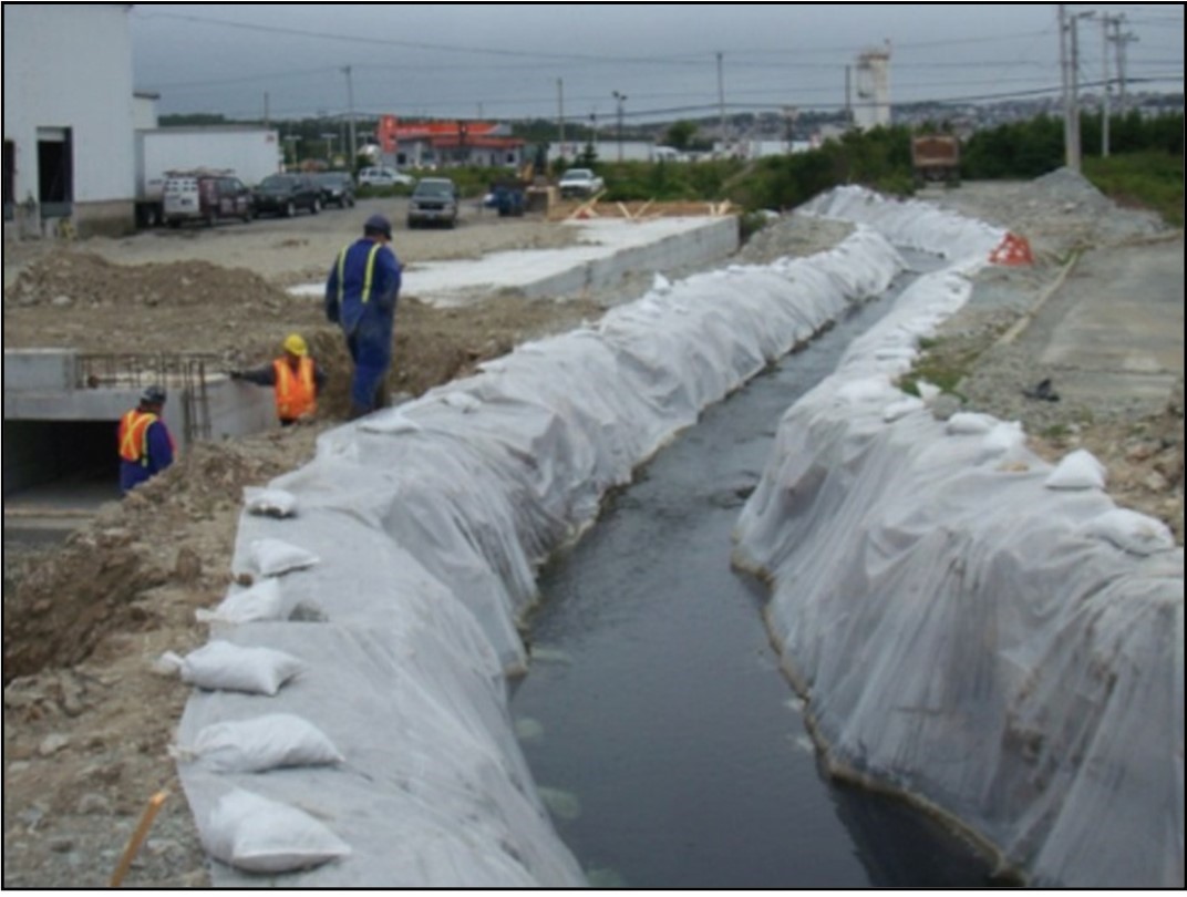
3.5.3 Elevated piping
Elevated pipes (Figure 3.41) can be used to carry out instream work in the dry as an alternative to the use of cofferdams and pumps or in circumstances where site constraints preclude the construction of a temporary diversion.

Best management practices on elevated piping are provided below:
- Use of elevated pipes should consider stream flows and the provision of fish passage Low stream flows are most suitable for use of this technique. Further, elevated pipes may impede fish passage
- The inlet and outlet of an elevated pipe are usually seated on cofferdams (e.g. double walls of sandbags with plastic placed between the walls). Upstream and downstream cofferdams should be placed into the stream and the pipe placed onto the cofferdams (Figure 3.42). Additional sandbags should then be placed on top of the pipe inlet and outlet to hold the pipe in place. If more than one pipe section is necessary to carry streamflow over the instream work area then consideration should be given to the impermeability of the area(s) where the pipe sections are coupled.
- Cofferdams should be checked periodically to ensure that water is not leaking into the work area or from the work area into the stream. Any such leaks should be repaired as soon as possible
- The instream work area should be fully stabilized and brought back to grade prior to removing the elevated pipe
- Sand bags, pipe sections, etc. should be removed upon project completion.
- Sediment-laden water within the work area should be pumped out and treated by discharging to settling ponds, vegetated areas or sediment traps (e.g. silt fences, filter fabric dams, etc.) prior to release to streams
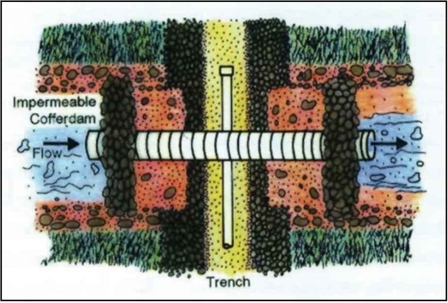
3.6 Water withdrawal
Improper design and/or construction of a water withdrawal structure can result in such adverse effects as dewatering of downstream areas, obstruction of fish passage and entrainment or impingement of fish on fish screens. Water withdrawal should be planned with consideration for maintenance of downstream flows and intakes should be equipped with fish screens (screening, netting or mesh) designed and installed in such a manner as to prevent potential losses of fish due to entrainment or impingement.
The installation and maintenance of a fish screen (Figure 3.43) at freshwater intakes is the responsibility of the proponent. This requirement is intended to limit the potential negative impacts that water extraction may have on fish present, the severity of which depends upon the abundance, distribution, size, swimming ability, and behavior of fish in the vicinity of the intake. As well, water velocity, flow and depth, intake design, screen mesh size, installation and construction procedures and other physical factors need to be considered.

Best management practices related to water withdrawal are provided below:
- Detailed guidelines for the provision of fish screens at small-scale water withdrawals up to 150 L/s (e.g. for small municipal, construction, irrigation, mining exploration, and private water supply projects) can be found in the end-of-pipe fish protection screens for small water intakes in freshwater code of practice on the Projects Near Water website
- Fish screen requirements for larger-scale water withdrawals will be considered by DFO and other regulatory agencies on a site-specific basis
- Flow regime and water balance in the area, as well as the need for provision of minimum downstream flows, should be considered when designing and constructing any water withdrawal system
3.7 Stormwater drains
Storm drains are used to conduct storm water away from developed lots, buildings and housing developments, etc. Water enters storm sewers from impervious structures such as parking lots, roads and building roofs as well as through soil percolation and inflow. Storm sewers frequently directly discharge into the nearest watercourse without any treatment or storage.
Storm drainage can have implications on stream basin hydrology and water quality of the receiving watercourse. An inflow of storm sewer water can change stream basin hydrology both in the rate and the quality of runoff. Rapid runoff during storms may cause bank destabilization, erosion, sedimentation, and displacement of fish. Reduced base flow conditions between storm events may decrease the amount of usable fish habitat and may cause a reduction in the standing stock of fish within a watercourse. Urban runoff can contain many contaminants including:
- bacteria
- heavy metals
- road salt
- sediment
- pesticides/herbicides
- a variety of organic compounds such as petroleum hydrocarbons
The introduction of such substances into the freshwater environment can negatively affect fish populations.
Best management practices for the design, installation and maintenance of stormwater drains are provided below:
- Storm drainage outlet structures should not be constructed directly on watercourse banks, but should be constructed some distance back and a channel excavated from the outlet structure to the watercourse. This channel should be constructed so that the general orientation of storm water discharge is parallel with stream flow (Figure 3.44)
- Sediment-laden water arising within work areas should be treated to remove sediment prior to release into a watercourse
- During construction, the inlets of storm sewer and drainage systems should be blocked or equipped with sediment traps (e.g. rock check dams, filter fabric dams, etc.)
- All excess materials resulting from excavation of the storm drainage channel and construction of the storm water outlet should be removed and disposed of at a site approved by the appropriate regulatory agencies
- The channel should be lined with clean stones to reduce the velocity of the water exiting the outlet structure. This will help to avoid streambed and streambank erosion.
- Storm drains should discharge onto riprap energy dissipators followed by a vegetated buffer zone rather than directly into a watercourse
- Once storm drain outlets have been properly constructed and stabilized, regular maintenance should be provided as necessary. Storm drains should be kept free of debris to avoid blockage of flow
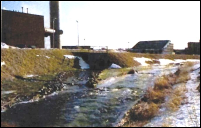
3.8 Borrow sites / quarries and asphalt / cement plants
The location of borrow sites/quarries and asphalt/cement plants should consider local drainage patterns, fish and fish habitat, and nearby watercourses. All proposed sources of borrow material should be approved by the appropriate regulatory agencies. Borrow sites/quarries and sites for asphalt/cement plant operations should allow for:
- space for an acceptable settling pond system(s) to remove suspended solids from any water used
- maintenance of a buffer zone of undisturbed vegetation between activities and natural watercourses (see Table 3.2)
Best management practices on borrow sites, quarries, and sites for asphalt/cement plant operations are provided below:
- No gravel or other borrow materials should be removed from watercourse banks, stream beds, or within the buffer zone (buffer zones are discussed in Section 3.4.2)
- Removal of stream bed materials can destroy fish habitat and create sedimentation that can have negative impacts downstream
- Runoff from gravel removal sites on hillsides or near small feeder streams can contribute substantial quantities of sediment-laden water into a watercourse.
- Materials should not be quarried from active flood plains
- Aggregate quarrying operations should be limited to areas above the design flood high water mark and no closer than 100 m from all watercourses. The vegetation within this buffer zone should remain undisturbed
- No excavations should encroach within watercourse boundaries or result in slope failure
- Small drainage channels should be diverted around borrow sites to avoid sedimentation
- Where site access roads cross a watercourse, a bridge or culvert should be installed (see Sections 3.3.2 and 3.3.3)
- Any water withdrawal requirements for the purpose of gravel washing should be reviewed by DFO (water withdrawal is discussed in Section 3.7)
- Runoff control devices or sediment traps (e.g. filter fabric dams, settling ponds, ditches, etc. (see Section 3.1)) should be used to prevent the entry of sediment-laden water into nearby watercourses
- The site should be appropriately rehabilitated and stabilized upon completion of quarrying, borrowing and asphalt/cement plant operations
3.9 Blasting / explosives
Blasting in or near water produces shock waves that can damage fish swim bladders and rupture internal organs. Blasting vibrations may also kill or damage fish eggs or larvae.
If explosives are required as part of a project, the potential for impacts to fish and fish habitat can be minimized by implementing the following measures:
- Adhere to appropriate fisheries timing windows for in-water works
- Large charges should be subdivided into a series of smaller charges and time-delayed to reduce the overall detonation to a series of smaller detonations
- Minimize blast charge weights used and subdivide each charge into a series of smaller charges in blast holes with a minimum 25 millisecond (1/1000 seconds) delay between charge detonations (see Figure 3.45)
Figure 3.45 Charge sub-divided into a series of smaller charges with a 25 millisecond delay 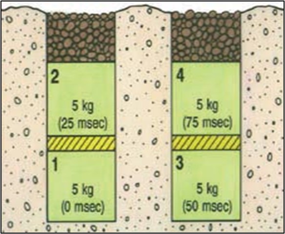
- The on-land set-back distance from the blast site to the watercourse and the set-back distance (zone) around the blast site are based on the maximum weight of the charge to be detonated at one instant in time and the type of fish and fish habitat in the area of the blast. Table 3.4. provides conservative safe distances from a watercourse. For more refined safe distances, detailed calculations can be found in the appendices of Wright, D.G., and G.E. Hopky. 1998. If on-land blasts are required nearer to the watercourse than indicated in Table 3.4, then additional mitigation measures should be initiated which include, but are not limited to, the installation of bubble/air curtains to disrupt the shockwave. When a bubble curtain is used, the curtain should surround the blast site and be started up only after fish have been moved outside of the surrounded area
- Isolate the work site to exclude fish from within the blast area by using bubble/air curtains (i.e., a column of bubbled water extending from the substrate to the water surface as generated by forcing large volumes of air through a perforated pipe/hose), cofferdams or aquadams
- Detonation of small scaring charges set off one minute prior to the main charge to scare fish away from the site
- Remove any fish trapped within the isolated area and release them unharmed beyond the blast area prior to initiating blasting
- To confine the blast, sand or gravel should be used to backfill blast holes to grade or to streambed/water interface
- Blasting mats should be placed atop the blasting holes to minimize the scattering of blast debris around the area
- Ammonium nitrate-based explosives (i.e. Ammonium Nitrate Fuel Oil mixtures, or ANFO) should not be used in or near water due to the production of toxic by-products (ammonia)
- All blasting and other associated equipment and products are to be removed from the blast area, including any debris that may have entered the aquatic environment
- If blasting is required to remove an ice jam, refer to the Best Management Practices for Ice Blasting in Newfoundland and Labrador (Fisheries and Oceans Canada, 2022b)
| Habitat | Weight of explosive charge (kg) | |||||
|---|---|---|---|---|---|---|
| 0.5 | 1 | 5 | 10 | 25 | 50 | |
| H1 | 7 m | 10 m | 15 m | 20 m | 35 m | 50 m |
| H2 | 15 m | 20 m | 45 m | 65 m | 100 m | 143 m |
H1 = rearing/general fish habitat
H2= spawning habitat where egg or early fish development is occurring
3.10 Dredging
Dredging requires the removal of material from the bed of a watercourse by mechanical means and has the potential to harmfully impact fish and fish habitat. Dredging often occurs in areas where the water depth precludes working in the dry.
In order to minimize the effects of dredging in standing freshwater, the following best management practices are provided:
- Time dredging activities to avoid periods where fish may be migrating through or near the work area. Dredging should occur during low flow periods to reduce the amount of sedimentation
- Isolate the work area with the use of a barrier orientated vertically from the water surface to the substrate to contain suspended sediment to the immediate work area. In deeper water, greater than 1.5 m, a floating boom with a suspended curtain anchored to the bottom should be installed to contain suspended sediment to the immediate work area. The barrier should be anchored/weighted to the substrate bottom profile, be appropriately floated at the surface, and, as necessary, be fastened into the shoreline (see Figure 3.46)
- Sensitive or important fish habitat should be avoided as per local recommended timing windows
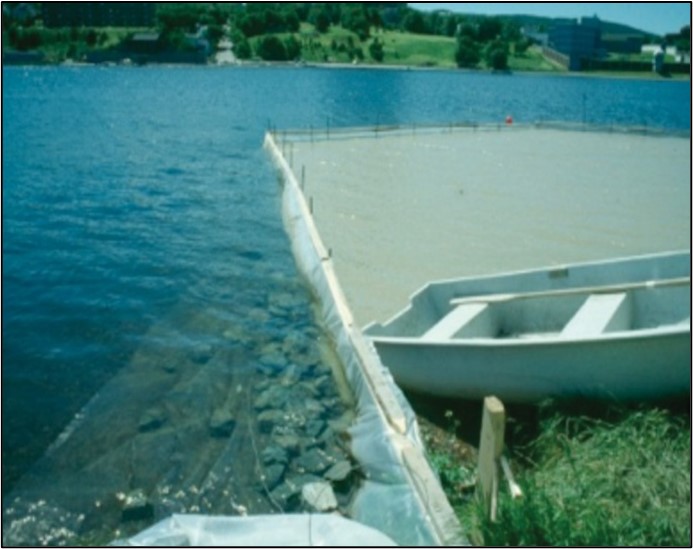
Depending on the time of year, dredging activities in estuaries could interfere with the seaward or return migration of anadromous (sea-run) salmonid species. This could have implications on fish survival or on spawning success (if the dredging activities interfere with return spawning migration).
Best management practices for dredging in estuary regions of rivers are provided below:
- time activities to avoid periods when migrating fish are passing through the area to be dredged
- dredge on a receding tide only
- dredging activities should cease when migrating fish (e.g. salmon, trout) are in the dredge area in significant numbers
- sensitive or important fish habitat should be avoided
Note: An ocean dumping permit may be required if dredged material is to be disposed of in the marine environment. Environment and Climate Change Canada should be contacted before carrying out any dredging activities in estuaries, in order to determine if a permit is required.
3.11 Forest harvesting and related activities
The growing mechanization of the logging/timber harvesting sector and the accelerated construction of access roads has increased the potential for these activities to negatively impact fish and fish habitat.
Potential adverse impacts of forestry activities on fish and fish habitat include:
- sedimentation resulting from erosion of exposed soils on watercourse banks
- obstruction of fish movements in watercourses by deposition of logs and slash
- depletion of the oxygen supply due to decomposition of organic material such as sawdust, bark, slash and sunken logs
- destruction of spawning and rearing areas by the instream use of heavy equipment
- leaching of fertilizers and herbicides
- destruction of streambank vegetation
The Forestry Guidelines for the Protection of Fish Habitat in Newfoundland and Labrador (Scruton et al. 1997) should be consulted for detailed forestry-related guidelines.
General recommended practices for forest harvesting are provided below:
- A buffer zone of undisturbed vegetation should be maintained between harvesting activities and watercourses (see Table 3.2)
- Slash, tops or any other logging debris should not be left within the high water mark of any watercourse
- Skid trails and landings should not be located in or adjacent to watercourses
- Watercourses should not be used for the driving or towing of logs
- Bridges are preferred for watercourse crossings. Portable bridges can be constructed using two sections of poles and two hardwood bedlogs. The poles are lashed together at both ends with a section of chain and then placed on the bedlogs
- Scarification of silviculture plots should be carried out parallel to the natural contours of the land. Scarification at right angles to the land will lead to erosion of unstable soils
- Prescribed burning treatments should be carried out so as to ensure that riparian (streamside) vegetation is not burned as part of the treatment
- In areas where fertilizers are prescribed, treatment zones should be located outside of buffer zones to prevent direct entry of fertilizers into fish habitat
Section 3.11.1 provides information on fish and fish habitat protection measures that should be incorporated into the use of forwarder trails.
3.11.1 Forwarder trails
Forwarder trails are used to transport timber to roadside. When the forest floor is compacted by machinery operating on trails, the natural filtering action of the soil is destroyed. Surface water is no longer absorbed, but is collected by wheel ruts, which act as drainage ditches (Figure 3.47). As the water flows into these ruts, soil is eroded and large volumes of sediment can be discharged into nearby watercourses, damaging fish habitat and aquatic life. A forwarder trail that has been left unprotected may continue to wash out and create sedimentation problems long after the harvesting operation has been completed.

Best management practices for forwarder trails are provided below:
- The location of forwarder trails should be planned to minimize the number of watercourse crossings. Where watercourse crossings are necessary, temporary bridges should be installed
- To ensure that sediment-laden water does not collect in wheel ruts and discharge into watercourses, mudlogs should be installed across trails before ruts develop. Mudlogs divert water and mud out of the forwarder track and onto the forest floor
- Mudlogs (Figure 3.48) should be installed close to where the water is entering the forwarder trail and where the ground slopes to one side. A small earthen dam is pushed up with the forwarder blade on an angle across the trail, and a 30 cm diameter log is placed immediately in front of the dam, on the uphill side. If conditions are extremely wet, several of these logs may have to be placed along the trail
- If mudlogs become compacted into the ground and are no longer effective, new mudlogs should be installed
- Mudlogs should be maintained in place to ensure that surface water is intercepted and deflected into surrounding vegetation

3.12 Linear development
The construction of linear developments (e.g. highways, resource roads, transmission lines, pipelines, and fibre optics cable development) involves a variety of activities. Earlier sections of this document have presented fish and fish habitat protection measures for several activities that are often associated with linear developments (i.e. ditching, watercourse crossings, right-of-way clearing, stormwater drains, borrow sites/quarries and blasting/explosives). All of these sections should be consulted when planning and designing a proposed linear development.
Due to the large number of activities involved in linear development, there are a variety of potential adverse effects that may result from poor design and construction of these facilities. Failure to consider fish and fish habitat protection measures during activities associated with linear developments can result in sedimentation of fish habitat. Blasting operations require mitigation to protect fish from injury. Inadequately designed watercourse crossings and stormwater drains can have implications on stream hydraulic characteristics and fish passage.
When designing and constructing linear developments, the following general best management practices should be considered:
- A buffer zone of undisturbed vegetation should be maintained between linear developments and watercourses (see Table 3.2)
- Design watercourse crossings and storm drainage systems with consideration for flow regime and water balance in the area of the crossing
- Developments should incorporate erosion and sediment control plans and all disturbed areas should be stabilized
Sections 3.12.1 through 3.12.3 present general information for various types of linear development
3.12.1 Highways / resource roads
Roads can cause negative environmental effects that degrade rather than enhance the natural environment. Unless roads are properly designed and planned, and care is exercised in construction, undesirable disturbances to aquatic environments are likely to occur (McCubbin et. al., 1990).
Best management practices for road construction are provided below:
- Determine road locations during the spring when seeps and springs are most noticeable
- Plan the road network layout so that the number of watercourse crossings is minimized
- Work should not be undertaken on easily erodible materials, during or immediately following heavy rainfalls
- Aggregate (fill) materials for road construction should not be removed from watercourses. This includes any area within the historical floodplain of a watercourse
- Where road construction or associated activities (e.g. grubbing, right-of-ways, etc.) take place adjacent to a watercourse, appropriate buffer zones of undisturbed vegetation should be maintained between the road or activities and the watercourse
- Roads should be adequately ditched to allow for good drainage. Roadside ditches should not open directly into a watercourse but should end blindly in vegetated or forested areas. Planning and construction of ditches should be carried out early in the road development process to ensure proper drainage throughout road construction
- Keep ditches at the same gradient as the road, wherever possible, and design to convey peak flows
- Prevent ditch flow into watercourses by constructing ditch runouts or takeoff ditches on road approaches a minimum of 30 m from watercourses
- Prevent flooding in wetland areas through the use of collector ditches and culverts to provide cross-drainage
- Frequently divert ditch flows into cross-drainage culverts to prevent erosion or overflow
- Provide appropriate watercourse crossing structures that consider protection of fish habitat and maintain fish passage. Bridges and culverts that require ongoing maintenance should be removed when the road is abandoned. Permanent maintenance-free structures should be left in place
- Inspect watercourse crossing structures prior to and during spring ice breakup. Debris caught on piers and at the entrance to culverts should be promptly removed to prevent obstruction to fish passage and upstream flooding. These regular inspections will also ensure that culverts and take off ditches are maintaining proper drainage
- Check watercourse crossing sites after the first heavy rain subsequent to installation to ensure that no erosion or sedimentation problems are developing
- Consideration should be given to regeneration of the right-of-way to make the area productive for growing trees and to prevent erosion
- Stabilize erosion prone cuts and fills with vegetation or other suitable material
- Siltation control structures, such as silt fences, filter fabric dams and rock check dams, should be installed
- Clean and provide regular maintenance for areas designated for sediment trapping
- Store all deicing and dust-control agents in areas where these substances cannot enter water bodies
- The use of mechanical brush control in the vicinity of water bodies is preferred over chemical methods (i.e. herbicides). The appropriate regulatory agencies should be contacted regarding the use of any chemicals in proximity to freshwater environments
3.12.2 Transmission lines
Like other linear developments, the activities involved in the construction of transmission line developments (watercourse crossings, right-of-way clearing, etc.) can have negative impacts on fish and fish habitat, such as habitat destruction or alteration and sedimentation. However, when properly managed, these harmful effects can be effectively mitigated.
Best management practices for transmission line development are provided below:
- Proposed transmission line routes and station locations should minimize the number of watercourse crossings
- Poles and towers should be located so as to minimize potential environmental damage and should not be located within watercourses or flood plains
- Right-of-way travel should be restricted to minimize watercourse crossings
- Watercourse crossings, including temporary bridges or fordings, should be appropriately designed, installed and implemented to provide protection of fish and fish habitat
- Activities associated with transmission line development (e.g. right-of-way cuttings, grubbing, etc.) should maintain an appropriate buffer zone of undisturbed vegetation from watercourses (see Table 3.2)
- All drainage channels and watercourse banks should be left in a stable condition at the end of construction
- As soon as possible following construction activities, disturbed areas should be appropriately stabilized by revegetation or other means
3.12.3 Fibre optic cable development
The activities involved in the construction of fibre optic cable developments (watercourse crossings, right-of-way clearing, etc.) can have negative impacts on fish and fish habitat, such as habitat destruction or alteration and sedimentation. However, when properly managed, these harmful effects can be effectively mitigated.
When planning and constructing fibre optic cable developments, the following best management practices are provided:
- Proposed fibre optic cable routes should minimize the number of watercourse crossings
- Underground watercourse crossings should be appropriately designed, installed and implemented to provide protection of fish and fish habitat (see Section 3.3.4)
- Activities associated with fibre optic cable development (e.g. right-of-way cuttings, grubbing, etc.) should maintain an appropriate buffer zone of undisturbed vegetation from watercourses
- All drainage channels and watercourse banks should be left in a stable condition at the end of construction
- As soon as possible following construction activities, disturbed areas should be appropriately stabilized by revegetation or other means
3.13 Mineral exploration
Without proper planning and implementation of mitigation measures, mineral exploration activities can result in a variety of chemical and physical impacts on fish and fish habitat. Chemical pollution of the freshwater environment can result from such releases as acid mine drainage, sewage discharge and accidental hydrocarbon spills. Physical impacts can be caused by mineral exploration activities if waste rock, particulate material, sand or gravel is dumped or washed into watercourses. In mineral exploration activities, the removal of vegetation and soil overburden is often necessary to gain access to the mineral deposit; topsoil and foliage can then wash into nearby watercourses resulting in siltation or obstruction of watercourses.
Common practices associated with mineral exploration include clearing and timber salvage, stripping and stockpiling, quarries and borrow areas, blasting, access road construction, watercourse crossings, and abandonment and rehabilitation.
Mitigation practices associated with these activities are addressed throughout this document. Best management practices associated with mineral exploration include:
- Careful planning should be undertaken to minimize the length and number of access roads/trails and watercourse crossing sites. This will help reduce potential erosion problems
- Water lines and access routes to drill sites should be located in areas that create the least amount of disturbance to fish and fish habitat
- If clearing and levelling are required, disturbed areas should be no larger than absolutely necessary
- Appropriate buffer zones should be maintained between watercourses and project development activities (e.g. grubbing and clearing zones)
- If trenches are to be left open for a period of time, excavated material should be contoured and stabilized to prevent erosion and sediment entering watercourses. Trenches and ditches should not be drained directly into a watercourse
- Drilling wastes should not be allowed to enter watercourses
- If drilling is undertaken through an ice covered watercourse, all debris that is frozen into the ice/snow should be removed and discarded upon abandonment. Debris (Figure 3.49) should be discarded at a disposal site approved by the appropriate regulatory agencies. Material should not be deposited in a watercourse due to ice thaw
- Measures to protect fish and fish habitat should be implemented during any blasting or water withdrawal activities

3.14 Urban Development
Watercourses in urban areas are altered for a variety of reasons ranging from flood control to maximizing land area available for development.
Roads, sewers, water mains, power lines and telephone cables cross watercourses within urban areas and, in most cases, do so more or less at random. Ideally, all developments, both residential and industrial, should be designed to retain the natural state of watercourses and to minimize stream diversions and crossings.
Addressed in previous sections of this document are mitigation techniques for:
- watercourse crossings
- diversions
- dams
- erosion/sedimentation control
- restoration of disturbed areas
- installation of water intake structures
- other urban development related activities
Physical habitat concerns associated with urban development include erosion, sedimentation, loss of riparian vegetation and obstruction of fish passage. The implications of urbanization on water quantity and quality should also be considered in addressing and implementing measures to mitigate potential impacts on fish and fish habitat.
Best management practices for urban development include:
- Buffer zones of undisturbed vegetation should be maintained between watercourses and development areas (see Table 3.2)
- Erosion/sedimentation control, runoff management and stormwater drainage systems should be incorporated into any development plan
- Urban road routes should be designed so as to minimize the number of watercourse crossings required
3.15 Hydroelectric developments
Activities associated with hydroelectric developments (dam construction, flooding/inundation, dewatering, etc) can have a negative impact on fish and fish habitat. Depending on the capacity of the storage basin and the quality of flows that are being diverted, the construction and operation of a hydroelectric facility can have the following impacts:
- Disruption of the existing hydraulic regime
- Obstruction of fish passage
- Water quality upstream and downstream of the dam may be degraded (increase in the bioaccumulation of mercury by fish) due to stagnation of the reservoir/headpond
- Increase in water temperature upstream caused by interrupted flow and possibly an increase downstream due to a reduced volume of water present
- Interruption of the food chain by the retention of nutrients in the reservoir/headpond area
- Loss of habitat due to the conversion of upstream free flowing water to a headpond or reservoir and inadequate flows downstream of the structure
When planning, operating or constructing hydroelectric developments, the following best management practices are provided:
- Maintenance/minimum flows should be provided downstream during construction of the dam and filling of the reservoir based on the sensitivity of the downstream fish habitat
- Appropriate minimum flows should be determined based on the appropriate instream flow needs methodologies and in consultation with DFO and other appropriate regulatory agencies
- Detailed hydrological information (mean monthly flows, mean annual flows, daily flows, flow duration information, water levels, runoff characteristics, etc.) should be used to assess the potential impacts upon fish, fish habitat, stream morphology, and hydrology
- Trees should be cut to approximately 10 cm above the ground and removed from the area to be flooded. Grubbing should not be carried out
- Buffer zones of undisturbed vegetation should be maintained between watercourses and development areas (see Table 3.2)
- All exposed erodible surfaces should be stabilized against erosion before the reservoir/headpond is flooded
- The predicted flushing rate of the proposed headpond or reservoir should be determined to address the bioaccumulation of mercury by resident fish
- Impacts of the entrainment/impingement of fish into the intake and tailrace should be determined and mitigated by using an intake screen or other appropriate methods
- The quantity and quality of fish habitat which may be impacted by flooding, dewatering and altered flow regimes should be determined. The fish species which utilize these habitats should also be identified
- Provision of fish passage via provision of appropriate flows, installation of a fishway, etc. should be addressed, as appropriate
- Measures to mitigate sedimentation and provide erosion control should be implemented
Fish and fish habitat protection measures associated with linear developments such as transmission facilities and access roads associated with hydroelectric developments should also be addressed.
4.0 Glossary
- Alevins:
- The newly hatched salmon with yolk sac still attached.
- Anadromous:
- Fish which migrate to freshwater to spawn but live all or part of adult life at sea.
- Baffle:
- A barrier or obstruction that deflects, checks or dampens water flow. Culvert baffles are flow interference structures usually in the form of low weirs.
- Ballast:
- Broken stone, gravel, slag, or similar material used to fill timber cribwork.
- Bank:
- The rising ground bordering a stream channel.
- Bed load:
- Sediment moving on or near the stream bed and frequently in contact with it.
- Berm:
- Mound of earth that can be used to direct or divert surface water.
- Buffer zone:
- Undisturbed border of vegetation (trees, shrubs, grass, etc.) along a stream or pond which isolates and protects the aquatic environment from nearby construction activities.
- Check dam:
- Impermeable dam constructed within a ditch to reduce water velocity, retain sediment, and prevent erosion.
- Cofferdam:
- An impermeable temporary structure used to divert flow and isolate an area in a watercourse or waterbody to allow work to be carried out in the dry while maintaining downstream flow and coastal currents. Construction can often be a double wall of sand bags with plastic in between.
- Culvert:
- A fiberglass, metal, concrete, plastic or wooden conduit used to pass water under an access route. Culverts are used to provide permanent or temporary access across a watercourse.
- Culvert lining:
- The re-enforcing of a culvert required because of a failure of the integrity of the structure, often as a result of corrosion or physical damage.
- Deleterious substance:
- Any substance that, if added to any water, would degrade or alter the water quality such that it could directly or indirectly harm fish, fish habitat, or the use of fish by humans.
- Dissolved oxygen:
- The concentration of oxygen dissolved in the water, expressed in mg/L or as percent saturation, where saturation is the maximum amount of oxygen that can theoretically be dissolved in water at a given altitude and temperature.
- Diversion channel:
- A temporary structure used to divert water from a watercourse to conduct instream work in the dry while maintaining downstream flow.
- Entrainment:
- Occurs when a fish is drawn into a water intake and cannot escape.
- Erosion:
- The process of soil and rock weathering caused by natural means (e.g. water, wind, ice, etc.) or by construction related disturbance.
- Filter fabric:
- Synthetic fabric used to remove suspended sediment in runoff from disturbed work areas; also used in the construction of some bank stabilization structures to prevent erosion.
- Fisheries resource:
- Fish stocks or populations that sustain commercial, recreational or subsistence fishing activities of benefit to Canadians.
- Flocculant:
- Chemical additive that holds minute suspended particles together.
- Flood plain:
- Flat land bordering a stream that is subject to flooding during high water events.
- Flow regime:
- Seasonal variations in the hydraulic characteristics of stream flows.
- Ford (fording):
- A shallow, stable crossing location that does not require alteration of the bed or bank of the watercourse, such as by wading across. Typically a one-time crossing (over and back).
- Gabion:
- A rock filled metal cage or basket used for bank or slope stabilization.
- Geotextile:
- Synthetic fabric used to stabilize banks & slopes; allows water to flow through but prevents the erosion of underlying soil.
- Grubbing:
- The removal of vegetation, stumps, debris, etc. from a development site.
- Hydrology:
- The study of water as it occurs on, over, and under the earth surface as streamflow, water, vapour, precipitation, soil moisture, and groundwater.
- Impermeable:
- Any material that will not permit passage of a fluid.
- Impingement:
- Occurs when an entrapped fish is held in contact with the intake screen and is unable to free itself.
- Invert:
- The lowest point in the internal cross section of an artificial or natural channel.
- Mitigation:
- Actions taken during the planning, design, construction and operation of works and undertakings to reduce or eliminate potential adverse impacts of activities on fish and fish habitat.
- No grub zone:
- An area of no grubbing (i.e., removal of vegetation, stumps, debris, etc.) for 30 m on each side of a watercourse.
- Ordinary high water mark:
- The usual or average level to which a body of water rises at its highest point and remains for sufficient time so as to change the characteristics of the land.
- Pool:
- A deep, slow moving, quiet portion of a stream.
- Rearing area:
- Shallow riffles or pools in a stream which provide young fish with adequate shelter and food.
- Riffle:
- A shallow section of a stream or river with rapid current and surface flow broken by gravel, rubble, or boulders. Usually separated by deeper pools.
- Riparian:
- Area adjacent to streams, lakes, and wetlands that support a unique mixture of water-tolerant vegetation from trees and shrubs to aquatic and herbaceous plants.
- Riprap:
- Angular rock used for bank and slope stabilization.
- Runoff:
- That part of precipitation appearing in surface streams.
- Salmonid:
- A fish belonging to Family Salmonidae, which includes salmon, trouts, chars, whitefish, and grayling.
- Scarify:
- To break up and loosen the surface of the ground.
- Sedimentation:
- The settling and accumulation of material out of the water column and onto the stream bed. Occurs when the energy of flowing water is unable to support the load of suspended sediment.
- Settling pond:
- Basin constructed to collect runoff from disturbed work areas and allow settling of sediment prior to release into the aquatic environment; often used in series.
- Slash:
- The residue left on the ground after trees are felled or accumulated there as a result of storm, fire or silvicultural treatment.
- Spawning area:
- Section of stream offering the appropriate size gravel, water velocity, and water depth for spawning and egg development.
- Straw barrier:
- Straw bales used in ditches to reduce water velocity, retain sediment, and prevent erosion.
- Swim bladder:
- A hydrostatic organ present in most fishes that consists of a gas-filled sac lying dorsal to the alimentary canal. Also known as the air bladder of a fish.
- Temporary clear span bridge:
- Small scale bridge structures (e.g., Bailey bridge or log stringer bridge) that completely span the watercourse, do not alter the stream bed or bank, and are a maximum of one lane wide. The bridge structure (including bridge approaches, abutments, footings, and armouring) is built entirely above the ordinary high water mark.
- Terrace:
- Sloping ground cut into a succession of benches for purposes of controlling surface runoff, minimizing soil erosion and encouraging revegetation.
- Topography:
- A general term to include characteristics of the ground surface such as plains, hills, and mountains, degree of relief, steepness of slopes, and other physiographic features.
- Undermining:
- The seepage or loss of water under a culvert, or other structure.
- Water balance:
- The balance between water entering a watershed and water leaving a watershed (i.e. precipitation minus all vapour and liquid transport losses out of a watershed).
- Wetted perimeter:
- The boundary of the channel cross section that is in contact with stream flow.
- Winter crossings (Ice bridges and snow fills):
- These are two methods used for temporary winter access in remote areas. Ice bridges are constructed on large watercourses that have sufficient stream flow and water depth to prevent the ice bridge from coming into contact with the stream bed or restricting water movement beneath the ice. Snow fills are temporary stream crossings constructed by filling a stream channel with clean compacted snow, and are typically used for crossing smaller watercourses.
- % exceedence:
- Refers to the percentage of time a particular flow within a watercourse is equaled or exceeded with respect to flow duration data. For example, a 90% exceedence value is in reference to the flow being equaled or exceeded 90% of the time.
5.0 Bibliography
American Iron and Steel Institute. 1984. Handbook of Steel Drainage and Highway Construction Products, Canadian Edition.
Andersen GB, Freeman MC, Freeman BJ, Straight CA, Hagler MM, Peterson JT .2012. Dealing with uncertainty when assessing fish passage through culvert road crossing. Environ Manage 50: 462–477. doi:10.1007/s00267-012-9886-6.
Bastien-Daigle S, Vromans A, and MacLean M. 1991. A Guide for Fish Habitat Improvement in New Brunswick. Department of Fisheries and Oceans - Gulf Region.
Behlke, CE., Lane DL, McLean RF and Travis MD. 1991. Fundamentals of Culvert Design for Passage of Weak-Swimming Fish. Alaskan Department of Transportation and Public Facilities and U.S. Department of Transportation.
Bley PW. 1987. Age, growth, and mortality of juvenile Atlantic salmon in streams: a review. U.S. Fish Wildl. Serv. Biol. Rep. 87(4). 25p.
Bradbury C, Roberge MM, and Minns CK. 1999. Life History Characteristics of Freshwater Fishes Occurring in Newfoundland and Labrador, with Major Emphasis on Lake Habitat Characteristics. Can. MS Rep. Fish. Aquat. Sci. 2485:vii+150p.
Buchanan RA, Scruton DA, and Anderson TC. 1989. A Technical Manual for Small Stream Improvement and Enhancement in Newfoundland and Labrador. Updated to Fisheries and Oceans Canada. 2021a.
Calkins DJ. 1989. Winter habitats of Atlantic salmon, brook trout, brown trout and rainbow trout: a literature review. Special Report 89-34, US Army Corps of Engineers, Cold Regions Research and Engineering Laboratory, Hanover, NH. 11p.
Castro-Santos T. 2005. Optimal swim speeds for traversing velocity barriers: an analysis of volitional high-speed swimming behavior of migratory fishes. J. Exp. Biol. 208(3): 421–432. doi:10.1242/jeb.01380. PMID:15671330.
Chilibeck B. 1992. Land development guidelines for the protection of aquatic habitat. BC Ministry of Environment, Lands and Parks, Integrated Management Branch.
City of St. John’s. 2020. The 1994 Development Regulations. Gazetted 1994 06 03. Last revised November 2020.
Conrad V and Jansen H. 1994. Fish Passage and Habitat Preservation for Highway Culverts. Eastern Canada. DFO. Doc. No. 94-01, 53 p.
Dane BG. 1978a. A review and resolution of fish passage problems at culvert sites in British Columbia. Fish. Mar. Serv. Tech. Rep. no. 810. 126 p.
Dane BG. 1978b. Culvert guidelines: recommendations for the design and installation of culverts in British Columbia to avoid conflict with anadromous fish. Fish. Mar. Serv. Tech. Rep. No. 811. 57 p.
Department of Fisheries and Oceans, Habitat Management Division, Newfoundland Region. No Date. A Guide to Trout and Salmon Habitat for Loggers.
Department of Fisheries and Oceans and Ontario Ministry of Natural Resources. 1994. Ontario Guidelines for Aquatic Plant Control. Can. Manuscr. Rep. Fish. Aquatic Sci. 2236: 25 p.
Department of Fisheries and Oceans and BC Ministry of Environment, Lands and Parks. 1994. Stream Stewardship - A Guide for Planners and Developers.
Department of Fisheries and Oceans. 1986. Policy for the Management of Fish Habitat.
Department of Fisheries and Oceans. 1987. Fish Habitat - The Foundation of Canada’s Fisheries.
Department of Fisheries and Oceans. 1988. Fish Habitat and Mining. Department of Fisheries and Oceans. 1991. Canada’s Fish Habitat Law.
Department of Fisheries and Oceans and LGL Limited. 1990. Urban Development: Guidelines for the Protection of Fish Habitat in Insular Newfoundland.
Department of Fisheries and Oceans. Fish Habitat Field Manual. Department of Fisheries and Oceans. 1994. Factsheet Series, Volumes 1 to 25. March, 1994.
Department of Fisheries and Oceans. 1995. Freshwater Intake End-of- Pipe Fish Screen Guidelines.
Department of Fisheries and Oceans, Habitat Management Division, Newfoundland Region. 1996. Habitat Management Operational Guidelines Draft, February 1996.
Department of Fisheries and Oceans. 2013. Measures to Avoid Causing Harm to Fish and Fish Habitat. Retrieved from https://www.dfo-mpo.gc.ca/pnw-ppe/measures-mesures-eng.html
Eagleridge International Limited. 2015. Environmental Protection Plan Big Triangle Pond Mineral Exploration Resource Access Road and Associated Mineral Exploration Activities. Retrieved from https://www.gov.nl.ca/eccm/files/env-assessment-projects-y2013-1725-1725-epp-empp.pdf.
Fisheries Act, Revised Statutes of Canada [1985, c. F-14]. Retrieved from https://laws-lois.justice.gc.ca/eng/acts/f-14/.
Fisheries and Marine Service. 1978. Guidelines for land development and protection of the aquatic environment. Fish. Mar. Tech. Rep. No. 807. 55 p.
Fisheries and Oceans Canada. 2019a. Fish and Fish Habitat Protection Policy Statement.
Fisheries and Oceans Canada. 2019b. Measures to protect fish and fish habitat. Available from https://www.dfo-mpo.gc.ca/pnw-ppe/measures-mesures-eng.html [accessed 27 July 2020].
Fisheries and Oceans Canada. 2020a. Interim code of practice: End-of-pipe fish protection screens for small water intakes in freshwater. Available from https://www.dfo-mpo.gc.ca/pnw-ppe/codes/screen-ecran-eng.html [accessed 27 July 2020].
Fisheries and Oceans Canada. 2020b. Interim code of practice: Temporary cofferdams and diversion channels. Available from https://www.dfo-mpo.gc.ca/pnw-ppe/codes/cofferdams-batardeaux-eng.html [accessed 27 July 2020].
Fisheries and Oceans Canada. 2020c. Interim code of practice: Temporary stream crossings. Available from https://www.dfo-mpo.gc.ca/pnw-ppe/codes/temporary-crossings-traversees-temporaires-eng.html [accessed 27 July 2020].
Fisheries and Oceans Canada. 2022a. A Technical Manual for Small Stream Improvement and Enhancement in Newfoundland and Labrador. Unpublished Manual.
Fisheries and Oceans Canada. 2022b. Best Management Practices for Ice Blasting for the Protection of Fish and Fish Habitat in Newfoundland and Labrador 2021. Unpublished Manual.
Fisheries and Oceans Canada, British Columbia Ministry of Environment, Kerr Wood Ladle Associates Limited and DB Laster and Associates Limited. 1980. Stream enhancement guide. Prepared by Stream Enhancement Research Committee, Vancouver, BC. 95 p.
Forty M, Spees J, Lucas MC. 2016. Not just for adults! Evaluating the performance of multiple fish passage designs at low-head barriers for the upstream movement of juvenile and adult trout Salmo trutta. Ecol. Eng. 94, 214–224.
Gibson RJ. 1993. The Atlantic salmon in fresh water: Spawning, rearing and production. Reviews in Fish Biology and Fisheries 3:39-73.
Gibson RJ, Stanbury DE, Whelan RR, and Hillier KG. 1993. Relative habitat use, and inter-specific and intra-specific competition of brook troup (Salvelinus fontinalis) and juvenile Atlantic salmon (Salmo salar) in some Newfoundland rivers. In: R.J. Gibson & R.E. Cutting [eds] Production of juvenile Atlantic salmon (Salmo salar) in natural waters. Can. Spec. Publ. Fish. Aquat. Sci. 118:53-69.
Goodchild GA and Metikosh S. 1994. Fisheries-Related Information Requirements for Pipeline Water Crossings. Can. Manuscr. Rep. Fish. Aquat. Sci. 2235:17 p.
Goerig E, Castro-Santos T, and Bergeron NÉ. 2016. Brook trout passage performance through culverts. Can. J. Fish. Aquat. Sci. 73(1): 94–104. doi:10.1139/ cjfas-2015-0089.
Goerig E, and Castro-Santos T. 2017. Is motivation important to brook trout passage through culverts? Can. J. Fish. Aquat. Sci. 74(6): 885-893, https://doi.org/10.1139/cjfas-2016-0237
Government of Newfoundland and Labrador, Department of Environment, Climate Change and Municipalities. 2021. Policy for Land and Water Related Developments in Protected Public Water Supply Areas. Retrieved from https://www.gov.nl.ca/eccm/waterres/regulations/policies/water-related/
Government of Newfoundland and Labrador, Department of Environment and Conservation, Water Resources Management Division. 2005. Environmental Guidelines for the Design, Construction and Operation of Water and Sewage Systems.
Government of Newfoundland and Labrador, Department of Fisheries and Land Resources. 2018. Environmental Protection Guidelines for Forestry Operations in Newfoundland and Labrador.
Government of Newfoundland and Labrador, Department of Municipal Affairs and Environment, Water Resources Management Division. 2018a. Environmental Guidelines for Bridges.
Government of Newfoundland and Labrador, Department of Municipal Affairs and Environment, Water Resources Management Division. 2018b. Environmental Guidelines for Culverts.
Government of Newfoundland and Labrador, Department of Municipal Affairs and Environment, Water Resources Management Division. 2018c. Environmental Guidelines for Fording.
Government of Newfoundland and Labrador, Department of Municipal Affairs and Environment, Water Resources Management Division. 2018d. Environmental Guidelines for Watercourse Crossings.
Government of Newfoundland and Labrador, Fisheries, Forestry and Agriculture. 2021. Remote Recreational Cottage. Retrieved from https://www.gov.nl.ca/ffa/lands/ownership/personal/remote-rec-cottage/
Government of Newfoundland and Labrador. Water Resources Management Division. 2018. Environmental Guidelines for General Construction Practices, https://www.gov.nl.ca/eccm/files/waterres-regulations-appforms-chapter10.pdf
Hardy Associates (1978) Ltd. 1989. Land Use Guidelines – Access Roads and Trails. Indian and Northern Affairs Canada.
Haro A, Castro-Santos T, Noreika J, Odeh M. 2004. Swimming performance of upstream migrant fishes in open-channel flow: A new approach to predicting passage through velocity barriers. Can J Fish Aquat Sci 2004 09;61(9):1590-601.
Harshbarger TJ. 1975. Factors affecting regional trout stream productivity. In: Proceedings, South-eastern Trout Resource: Ecology and Management Symposium. U.S. Department of Agriculture, South-eastern Forest Experiment Station, Asheville, North Carolina, p11-27.
Jacques Whitford Environment, Acres International Ltd. and T.R.Payne and Associates. 1997. Evaluation of Instream Flow Needs Assessment Methodologies in Newfoundland. 5. Guidelines for Use. Report to the Canada-Newfoundland Agreement Respecting Water Resources Management and the Green Plan, Habitat Action Plan.
Jacques Whitford Environment, Acres International Ltd. and T.R. Payne and Associates. 1996c. Evaluation of Instream Flow Needs Assessment Methodologies in Newfoundland. 1. Review of Methodologies. Report to the Canada Newfoundland Agreement Respecting Water Resources Management and the Green Plan, Habitat Action Plan. vi + 44 pp.
Jin G, Lester P, McCarthy T. 2003. Bridges on the Trans Labrador Highway. Government of Newfoundland and Labrador. Department of Works, Services and Transportation, Highway Design and Construction Division. Paper prepared for presentation at the Bridges – Engineering Impacting Society (B) Session of the 2003 Annual Conference of the Transportation Association of Canada St. John’s, Newfoundland and Labrador
Mahlum S, Cote D, Wiersma YF, Kehler D and Clarke KD. 2014. Evaluating the Barrier Assessment Technique Derived from FishXing Software and the Upstream Movement of Brook Trout through Road Culverts, Transactions of the American Fisheries Society, 143:1, 39-48
McCubbin RN, Case AB, Rowe DA and Scruton DA. 1990. Resource Road Construction: Fish Habitat Protection Guidelines. Department of Fisheries and Oceans and Canadian Forestry Service.
Mineral Act [RSNL1990 CHAPTER M-12]. 2014. Government of Newfoundland and Labrador. Retrieved from https://www.assembly.nl.ca/legislation/sr/statutes/m12.htm
Nalcor Energy. 2014. LITL Vegetation Protection and Environmental Effects Monitoring Plan. Nalcor Doc. No. ILK-PT-MD-0000-EV-PL-0006-01. Retrieved from https://muskratfalls.nalcorenergy.com/wp-content/uploads/2014/08/LIL_Vegetation-Protection-Environmental-Effects-Monitoring-Plan.pdf
Nalcor Energy. 2016. TL 267 Overland Transmission Environmental Protection Plan. Retrieved from https://www.gov.nl.ca/eccm/files/env-assessment-projects-y2015-1803-plans-approved-files-epp-june-2016-final.pdfNew Brunswick Department of Transportation. 1995. Environmental Protection Plan. NB Department of Transportation.
Newfoundland and Labrador Petroleum Regulations, 1991. Newfoundland and Labrador Hydro, Environmental Services Department. 1988. A Generic Environmental Protection Plan for Newfoundland and Labrador Hydro Transmission Facilities.
Newfoundland Department of Environment, Water Resources Management Division. 1993. Guidelines for Preparing Development Plans for Forest Harvesting Operations Within Protected Water Supply Areas.
Newfoundland Department of Environment, Water Resources Management Division. 1994. Environmental Guidelines for Stream Crossings by All-terrain Vehicles.
Newfoundland Department of Natural Resources. 1995. Guidelines for Conducting Petroleum Exploration Surveys in the Newfoundland and Labrador Onshore Area. Draft January, 1995.
Newfoundland Department of Natural Resources, Mineral Lands Division. 1995. Environmental Guidelines for Construction and Mineral Exploration Companies.
Newfoundland Department of Natural Resources, Mineral Lands Division. 1993. Office Consolidation of The Quarry Materials Regulations.
Nyman OL. 1970. Ecological interaction of brown trout, Salmo trutta L. and brook trout, Salvelinus fontinalis (Mitchell), in a Stream. Can. Field. Nat. 84: 343- 350.
O'Connell MF, Dempson JB. 2002. The Biology of Arctic Charr, Salvelinus Alpinus, of Gander Lake, A Large, Deep, Oligotrophic Lake in Newfoundland, Canada. Environmental Biology of Fishes 64, 115–126. https://doi.org/10.1023/A:1016001423937
Peake SJ. 2008. Swimming performance and behaviour of fish species endemic to Newfoundland and Labrador: A literature review for the purpose of establishing design and water velocity criteria for fishways and culverts. Can. Manuscr. Rep. Fish. Aquat. Sci. 2843: v + 52p.
Peterson RH. 1978. Physical characteristics of Atlantic salmon spawning gravel in some New Brunswick streams. Fish. Mar. Serv. Tech. Rep. 785 vi+28p.
Province of New Brunswick. Department of Environment. 2012. Watercourse and Wetland Alteration Technical Guidelines.
Raleigh RF. 1982. Habitat Suitability Index Models: Brook Trout. U.S. Department of Interior, Fish and Wildlife Service, FWS/OBS-82/10.24.
Rodgers EM, Heaslip BM, Cramp RL, Riches M, Gordos MA, Franklin CE. 2017. Substrate roughening improves swimming performance in two small-bodied riverine fishes: implications for culvert remediation and design. Conserv Physiol 5(1): cox034; doi:10.1093/conphys/cox034.Kiffney et al. 2009
Scott WB and Crossman EJ. 1964. Fishes occurring in the fresh waters of Newfoundland. DFO. Ottawa. 124 p.
Scott WB and Crossman EJ. 1998. Freshwater Fishes of Canada. Galt House Publications, Oakville ON. 966 p.
Scruton DA, McKinley RS, Booth RK, Peake SJ, and Goosney RF. 1998. Evaluation of Swimming Capacity and Potential Velocity Barrier Problems for Fish Part A. Swimming Performance of Selected Warm and Cold Water Fish Species Related to Fish Passage and Fishway Design. CEA Project No.9236 G 1014, Montreal, Quebec. xiv + 62 pp., 2 appendices.
Scruton DA, Sooley DR, Moores L, Barnes MA, Buchanan RA, and McCubbin RN. 1997. Forestry Guidelines for the Protection of Fish Habitat in Newfoundland and Labrador. Fisheries and Oceans, St. Johns, NF. iii + 63 pp., 5 appendices.
Sooley DR, Luiker EA and Barnes MA. 1998. Standard Methods Guide for Freshwater Fish and Fish Habitat Surveys in Newfoundland and Labrador: Rivers and Streams. Fisheries and Oceans, St. John’s, NF. iii + 50 pp.
White RJ and Brynildson OM. 1967. Guidelines for management of trout stream habitat in Wisconsin. Wis. Dept. Nat. Resources Tech. Bull. 39. 65 p.
Wright DG, and Hopky GE. 1998. Guidelines for the use of explosives in or near Canadian Fisheries waters. Can. Tech. Rep. Fish. Aquat. Sci. 2017 iv + 34p
Appendix A
Appendix A focuses on salmonid biology and habitat requirements but it is recognized that there are other, non-salmonid species found within the province.
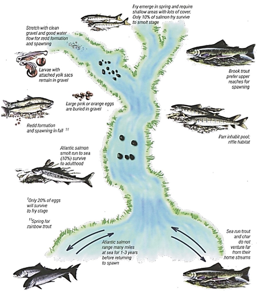
Text version: Figure A1 Typical life cycle and habitat requirements of a salmonid fish (from Buchanan et al. 1989)
Brook trout prefer upper reaches for spawning.
Parr inhabit pool and riffle habitat.
Stretch with clean gravel and good water flow for redd formation and spawning.
Large pink or orange eggs are buried in gravel. Only 20% of eggs will survive to fry stage.
Larvae with attached yolk sacs remain in gravel.
Fry emerge in spring and require shallow areas with lots of cover. Only 10% of salmon fry survive to smolt stage.
Atlantic salmon smolt run to sea (10%) survive to adulthood.
Sea run trout and char do not venture far from their home streams.
Atlantic salmon range many miles at sea for 1-3 years before returning to spawn.
Redd formation and spawning in fall. Spring for rainbow trout.
The majority of the freshwater species fished in Newfoundland and Labrador are salmonids. The term salmonid refers to any fish species of the Family Salmonidae. There are 32 species of salmonids in Canada. Of these, 8 occur in Newfoundland and Labrador:
- Atlantic Salmon or ouananiche (Salmo salar)
- Brook Trout (Salvelinus fontinalis)
- Arctic Char (Salvelinus alpinus)
- Lake Trout (Salvelinus namaycush)
- Lake Whitefish - including dwarf form (Coregonus clupeaformis)
- Round Whitefish (Prosopium cylindraceum)
- Brown Trout (Salmo trutta)
- Rainbow Trout (Oncorhynchus mykiss)
Some of the salmonid species are difficult to distinguish, particularly at the younger stages. Fish from saltwater or from different ponds or streams may differ considerably in coloration and general appearance. In addition, some of these species, such as brown trout, may interbreed with salmon or brook trout to produce hybrids. The brown-brook trout cross is termed “tiger trout” and may be fairly common on the Avalon Peninsula. Additional salmonid species in the province are lake trout and whitefish that occur only in Labrador (some lake whitefish may be found in isolated areas in Newfoundland). Atlantic salmon and brook trout are, by far, the most important freshwater fish on the island portion of the province with Arctic char also playing an important role in Labrador.
This section of the manual, from reference documents specific to Newfoundland and Labrador, is a very brief overview of the range of habitat preferences for the various life cycle stages of numerous salmonids including:
- Atlantic salmon/ouananiche
- brook trout
- Arctic char
- brown trout
- rainbow trout
The first 3 species have been highlighted since these represent the species most fished and in fact the species for which most enhancement and restoration projects are conducted. The last two are introduced salmonid species that have gained status in the province as a sport fish. They can also compete with resident species and hence their habitat requirements are briefly outlined.
In addition to salmonids, other recreational/subsistence fish species may be present, particularly in Labrador, such as:
- American Eel (Anguilla rostrata)
- Northern Pike (Esox Lucius)
- Rainbow Smelt (Osmerus mordax)
- Longnose Sucker (Catostomus catostomus)
- White Sucker (Catostomus commersoni) Burbot (Lota lota)
All 8 of the listed salmonid species, as well as American eels and rainbow smelt, are similar in that they all have the biological capability of moving between fresh and saltwater although not all populations do so. Populations that spawn in freshwater but run to sea for feeding purposes are termed sea-run or anadromous. As discussed in the previous sections, stream-resident salmonids are similar in their general habitat requirements for:
- a dependable supply of clear, cool, well oxygenated water
- clean spawning gravels
- shelter in the form of instream and stream bank cover
- food from both aquatic and terrestrial sources
- a mixture of pool and riffle habitat
There are specific differences between species in time of spawning, some differences in the type of area where a species can spawn successfully (i.e. headwater stream vs. rocky shoal in a lake), and differences in adult feeding areas.
Habitat requirements of salmonids in Newfoundland and Labrador
Atlantic Salmon / Ouananiche

Background information
Spawning usually occurs between October 15 and November 20 in Newfoundland and between September 1 and October 31 in Labrador (Scruton et al., 1997). Redds, or nests, consist of several depressions 10-50 cm deep where the female will lay her eggs (Bley, 1987; Calkins, 1989). Once eggs are laid and fertilized, the female will cover the eggs with about 10-25 cm of substrate (Bley, 1987).
Redds are normally a distinctive, elongated mound of relatively clean gravel. The optimum location for a spawning redd is a shallow, gravelly area at the tail of a pool where the water velocity is increasing. Other locations may include the head of a pool, the downstream end of riffles or areas near upwelling of ground water. Before and after spawning, nearby pools may be used by adults for resting.
Eggs incubate during winter and will usually hatch in April. The newly emerged alevin will remain in the gravel until their yolk sac is absorbed (typically May or June). Fry will emerge from the gravel and stay in shallow riffle areas near the redd until about 65 mm in length.
Typical juvenile (parr) habitat is composed of riffle areas with gravel or cobble substrate (Buchanan et al. 1989). Good rearing habitat in Newfoundland is generally characterized by large numbers of instream boulders where young can shelter.
Life stage, habitat variable and suitable range of values (from literature)
Eggs
- Remain buried in the redd until hatching
- Generally speaking hatching takes place in April (~110 days after spawning at water temperatures of 3.9⁰C)
- Eggs may die if water temperature exceeds 12⁰C (Scott and Crossman 1998)
Redd
- Substrate:
- Coarse gravel (2.5 – 8 cm in diameter); can be up to 50 cm deep in gravel and covered by 20 cm of substrate
- Water depth:
- Optimum water level ranges 15-61 cm
- Water velocity:
- Optimum velocity of current over redd 15-76 cm/s (upwelling and downwelling necessary for successful incubation)
Emergence
- Lower substrate embeddedness is considered better for emergence
Fry
- Substrate:
- Young-of-year have been associated with substrates of 0.0062- 25 cm in diameter
- Best suitable substrate for summer is considered gravel (0.2-3 cm in diameter)
- Best suitable substrate for winter is considered cobble (6-13 cm in diameter)
- Water depth:
- Young-of-year have been associated with depths ranging from 10-70 cm
- Suitable mean depth for highest fry density: 10-30 cm (best is suggested as 15-22 cm: minimal densities at depths >60 cm)
- Water velocity:
- Best suitable mean velocity for highest fry density: 15-70 cm/s (best suggested as 20-60 cm/s)
- Stream width:
- Suitable mean stream width at minimum summer flow for production of fry: 0.5-4 m
- Cover:
- Suitable % cover at minimum summer flow for production of fry: 0-50% (best suggested as 0-30%)
- Suitable % cover for production of fry (winter): 60-100% (best is suggested as 75-100%)
Parr
- Substrate:
- Associated substrate range of 0.0004 cm-bedrock
- Water depth:
- Associated water depth range of 10-85 cm
- Water velocity:
- Associated mean water column water velocities of 0 - 95cm/s
- Water temperature:
- Suitable temperature for optimal instantaneous growth of parr: 11-24°C
- Cover:
- suitable % instream cover (boulders and/or logs) for high habitat quality of parr: 0-68% (best suggested as 23-62%)
Arctic Char

Background information
Arctic char are principally found in Labrador, however, some populations are known to occur within Newfoundland in some of the deeper lakes, on the Northern Peninsula (Bradbury et al. 1999) as well as Gander Lake (O’Connell and Dempson 2002), with a few anadromous populations. Char are usually very slow growing with the largest ones normally recorded from the northern anadromous populations.
Anadromous char may migrate to the sea for feeding during summer but they do not range as far from their home rivers as do Atlantic salmon (tens of miles vs. hundreds of miles) and they do not jump obstacles as well as salmon.
Life stage, habitat variable and suitable range of values (from literature)
Redd
- Substrate:
- Optimal spawning substrate is suggested as consisting of a range between sand and cobble. Size range would therefore range between 0.1 – 13 cm
- Water depth:
- Variable, however usually occur between 1.5 - 2 m.
- Water velocity:
- Variable but similar to that of brook trout (0.2 - 0.5 m/s).
Fry
- Substrate:
- Young-of-year are typically associated with larger substrates of 6 - 100 cm in diameter
- Water depth:
- Young-of-year have been associated with relatively shallow depths (<20 cm)
- Water velocity:
- Young-of-year have been generally associated with mean velocities of <1.0 m/s
Juvenile
- Substrate:
- Associated substrate range of 0.004 mm-100 cm
- Water depth:
- Have been associated with relatively shallow depths (<20 cm)
- Water velocity:
- Have been generally associated with mean velocities of <1.0 m/s
Brook Trout

Background information
Brook trout are also known locally as mud trout and speckled trout. They are the most common salmonid in Newfoundland streams and ponds and are an important recreation and food fish. A portion of some populations may migrate to the ocean, generally staying within the brackish, estuarine habitat.
Brook trout spawn between October 1 and 31 on Insular Newfoundland and between September 1 and 30 in Labrador (Scruton et al., 1997).
Preferred spawning areas are in cool, clear headwater streams with clean well-ventilated gravel, in water depths of approximately 61 cm. Spawning can also occur in lakes, particularly in gravelly areas subject to spring upwelling and moderate water currents.
Female brook trout digs a redd and deposits her eggs. One male is in attendance but both sexes will drive out intruders. Some Newfoundland trout mature at a very small length (eg. 8-15 cm); some are precocious while others are dwarf populations.
Eggs will hatch in approximately 100 days (exact timing depends upon water temperature). The dissolved oxygen content of the water flowing through the redd should not fall below 50% saturation for embryo development to occur (Harshbarger, 1975). The young (alevin) will remain within the spaces in the gravel until their yolk-sac is absorbed (~38 mm in length).
The fry prefer the quiet, shallow edge areas of a stream and they tend to utilize pools more than young salmon. Older juveniles tend to frequent the riffle areas.
Temperature tolerance ranges between 0-25 °C although acclimation is required for extreme changes. Optimal growth of brook trout occurs between 11-14 °C (Raleigh, 1982).
Optimal brook trout habitat in streams is characterized by a pool:riffle ratio of 1:1, well vegetated banks, abundant instream cover, and stable water flows and temperatures. Instream cover and deep pools may also be very important for ensuring overwintering success.
Life stage, habitat variable and suitable range of values (from literature)
Redd
- Substrate:
- Optimal spawning substrate is suggested as consisting of a range between 3 - 18 cm
- Optimum substrate size for embryos is suggested as 0.3 - 5.0 cm
- Water depth:
- Variable
- Water velocity:
- Variable but usually less than that of Atlantic salmon (upwelling and downwelling necessary for successful reproduction)
Fry
- Substrate:
- Young-of-year have been associated with substrates of 10- 40 cm in diameter
- Water depth:
- Young-of-year have been associated with depths ranging from 27-40 cm
- Water velocity:
- Young-of-year have been associated with focal velocities of 0.5-4.3 cm/s (in winter)
Juvenile
- Substrate:
- Associated substrate range of 0.004 mm - 1 m
- Water depth:
- Associated water depth range of 40 - 95 cm
- Water velocity:
- Aassociated focal water velocities of 4.6 - 17.8 cm/s
Brown Trout

Background information
Brown Trout are common on the Avalon Peninsula where sea- run populations have become established. In some areas, they may tend to displace native brook trout since they are more tolerant of certain kinds of pollution such as increased turbidity and warmer water temperatures. They tend to occupy lower stream reaches, grow faster and to a larger size, live longer and are harder to angle than brook trout. Browns have a preference for undercut banks and grassy areas. Sometimes the largest fish will be found hiding in grasses in very shallow water.
Brown trout generally spawn in the late fall - early winter period; later than brook trout. Their eggs are amber in colour as opposed to the other salmonids whose eggs are orange or pink. Eggs usually hatch in April. They are capable of producing hybrids with both brook trout (called 'tiger trout'), salmon and rainbow trout.
Habitat requirements
Habitat requirements of brown trout are similar to those of brook trout.
Brown trout are more tolerant of high temperatures and can tolerate a range between 0°C and 27°C, although optimal growth is between 12°C and 19°C (Raleigh et al., 1986).
Brown trout are less tolerant of low pH than brook trout and normally occur within a pH range of 5.0 - 9.5 (Raleigh et al., 1986).
They may utilize the same gravel substrate in headwater spawning areas as brook trout as well as habitat in the lower reaches.
Rainbow Trout

Background information
Rainbow trout were originally native to western North America but have been introduced throughout. Sea-run populations are known as steelhead and are a most sought after game fish.
Rainbows were introduced to Newfoundland from the mainland in 1887. They have been transplanted in various locations across the province over the years and are now found in many systems on the Island portion of the province. They generally prefer more open and faster water than do brook trout of equal size.
Growth and maximum size is highly variable and dependent upon environmental conditions. They are not particularly long-lived (i.e. about 6-8 years).
Habitat requirements
Adults in Newfoundland prefer lake habitat (clear, cold, deep lakes) over stream habitat except during spawning season. Inlet or outlet streams with gravel bottom riffle areas are normally required for spawning purposes. Young rainbows normally move into the lake environment during the first growing season or after overwintering in their natal stream.
Rainbow trout typically spawn in the spring with their preferred spawning sites being fine gravel beds in riffles above a pool.
Lake-dwelling populations appear to require feeder streams for successful spawning.
The timing of egg development is highly dependent upon local conditions but eggs normally hatch in about 4 - 7 weeks. Alevins require an additional 3 - 7 days to absorb the yolk before becoming free swimming.
Appendix B
Environmental Emergencies 24-Hour Report Line number (709-772-2083 or 1-800-563-9089) should be utilized to:
- report an incident originating from a marine vessel or other marine source;
- to report an incident originating on land, inland waters or from a land-based source; or
- to report an emergency involving a marine animal.
Chemical or hydrocarbon spills greater than 70 litres must be reported. However, it is recommended that spills less than 70 litres also be reported. If required, refer to the Canadian Environmental Protection Act for a list of regulated toxic substances. Additionally, to ensure a quick and effective response to a spill event is possible, spill response equipment, such as adsorbents and open-ended barrels for collection of cleanup debris, should be readily available and stored in an accessible location on-site for any work in or near freshwater. Personnel working on the project should be knowledgeable about response procedures.
To report an environmental concern which is not an emergency please contact:
- an Environmental Protection Officer located at the nearest Government Service Centre office
- Crime Stoppers of Newfoundland and Labrador (1-800-222-TIPS [8477])
Contact information
Regional Office: Fish and Fish Habitat Protection Program
Fisheries and Oceans Canada
80 East White Hills Road
P.O. Box 5667
St. John’s NL A1C 5X1
Phone: 709 772-4140
Email: dfo.fppnl-ppptnel.mpo@dfo-mpo.gc.ca
- Date modified: