
Cruising in Comfort: Ship safety supported by science and technology
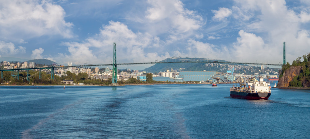
Photo credit: Shutterstock
The collapse of the Francis Scott Key Bridge in March 2024 after it was struck by a container ship in Baltimore, Maryland, provided some frightening images of what can happen when things don't go according to plan. The question many people may have asked themselves, naturally enough, was: "What are the chances of something like that happening here?" Thankfully, not only are these types of incidents incredibly rare, but the integration of scientific data and knowledge is critical in helping ensure that marine infrastructure remains safe and secure on an ongoing basis given the significant volumes of vessel traffic in today's world.
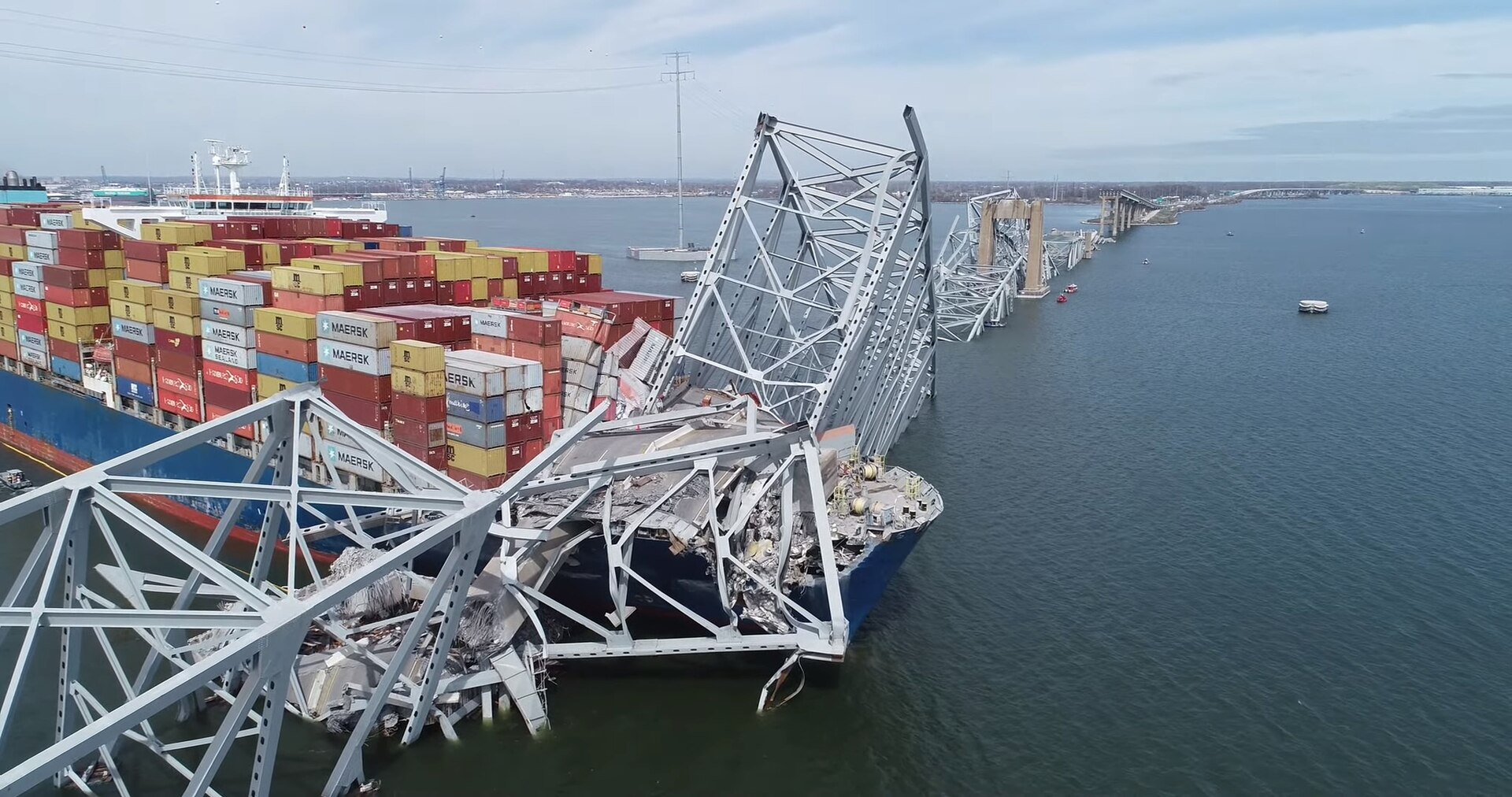
Photo: U.S. National Transportation Safety Board (public domain)
It may surprise you to know just how much science goes into ensuring the safety of marine infrastructure. The simple fact of a ship going under a bridge requires reliable access to accurate real-time tidal data, including information on water currents, as well as precise calculations of vertical clearance based on vessel size, weight, and available infrastructure. Add to that the immense size of many of today's vessels, and the sheer number of them passing underneath a variety of structures, and one can begin to understand the complexity of the undertaking at hand.
For example, Canada's Pacific coast has become a very popular destination for many cruise lines—in 2024, there were 329 visits planned for Vancouver alone!
"One of the biggest changes we've seen in the port environment over the years has been the growth in both cargo and passenger volumes," says Sean Baxter, Director of Marine Operations and Harbour Master for the Vancouver Fraser Port Authority.
"While the number of ships has remained relatively stable, the vessels themselves have grown. Engineering improvements have allowed for larger vessels with higher capacities."
In other words, while the ships are getting bigger, the bridges aren't getting any taller—but thankfully, the science of hydrography comes to the rescue. Broadly speaking, hydrography is the science of measuring and describing the physical features of navigable waterways.
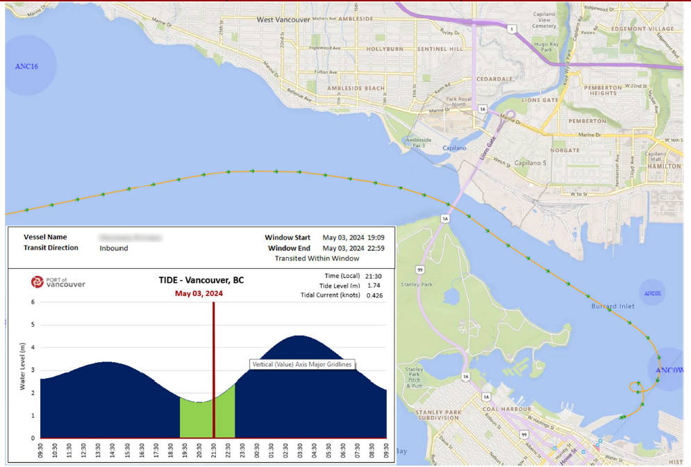
Water level chart showing optimum ship transit window based on water levels and currents, used to help guide safe cruise ship transits under the bridge.
Mariah McCooey, Director of Hydrography for the Canadian Hydrographic Service (CHS) in Victoria, notes: "The Vancouver Fraser Port Authority, among others, makes use of CHS's integrated water level system to ensure reliable access to real-time tides, vertical clearances, and precise currents. This helps to ensure safe transit window predictions for ships transiting under the Lions Gate Bridge here in Vancouver."
"The marine environment is a very dynamic space and we're dealing with a number of different variables," notes Sean Baxter. "About a third of cruise chips now are required to enter port under tidal restrictions, which makes CHS data about water levels and tides vital to enabling cruise ship operators to plan effectively."
Another consideration to keep in-mind is that the level of the bridge itself can also be variable, at least to a certain extent.
"Lions Gate Bridge is a cable-supported bridge, meaning that its level can vary as well depending on prevailing conditions," explains Baxter.
When it comes to today's complex webs of marine traffic, supporting cruise ships, pleasure craft and other vessels, not to mention the need to be mindful of the region's many iconic wildlife species such as orcas and sea lions, science and technology play a key role in keeping things running smoothly. In fact, an average of three thousand ships transit the Port of Vancouver safely and securely each year, thanks in part to the accurate and reliable data provided by the Canadian Hydrographic Service.
"In 2024, it's expected that approximately 1.3 million passengers will pass through the Port of Vancouver," notes Baxter. "And it's estimated that the Vancouver cruise industry injects an average of more than $3 million into the local economy for each ship visit."
"The dedicated hydrographers of the CHS are doing much more than providing measurements," says Mariah McCooey. "It's really an operational science. Our work underpins a massive economic machine. We are completely reliant on deep sea shipping here on the coast and without precise information on depth, water levels, and currents, none of this could happen."
- Date modified: