
Oceans management decision making
Purpose
To provide an introductory overview of Ministerial powers and responsibilities in three areas:
- Marine conservation
- Marine environmental quality
- Marine spatial planning
Marine conservation
The Minister has the power to establish marine protected areas, marine refuges, and ecologically significant areas
Summary
- Under the Oceans Act, the Minister recommends that the Governor-in-Council (GiC) establish marine protected areas (MPAs) through regulations
- The Minister may also establish marine protected areas (MPAs) through Ministerial Order (MO) regulations for up to five years
- Under the Fisheries Act, the Minister may establish marine refuges, which count as Other Effective Area-Based Conservation Measures (OECMs) in Canada’s international marine conservation targets
- Under the Fisheries Act, the Minister may establish ecologically significant areas (ESAs) through regulations to protect sensitive, highly productive, rare or unique areas
Definitions:
- MPA: Part of the ocean that is legally protected and managed to achieve the long-term conservation of nature
- Marine refuge: Part of the ocean (other than an MPA) which is governed and managed in ways that achieve positive and sustained outcomes for the conservation of biodiversity, for example by restricting certain kinds of fishing gear (e.g., gillnets) or practices (e.g., bottom trawling)
- ESA: Part of the ocean identified through formal scientific assessments as having special ecological significance when compared with the surrounding marine ecosystem
Marine conservation: Policy and process
- In April 2019, new standards for MPAs were announced, namely the prohibition of the following activities within these areas:
- Oil and gas
- Mining
- Dumping
- Bottom Trawling
- The rigorous 5-step Oceans Act MPA establishmentprocess can take between 7 and 10 years to complete.
- Allows for extensive information gathering and consultation to occur prior to the Minister’s approval and recommendation of the regulatory package to the GiC (i.e. Treasury Board) (Step 4)
- 2019 changes to the Oceans Act enable MPA establishment using MO regulations to provide interim protection for vulnerable areas while science and consultation continue to establish a long-term GiC MPA
- Also announced new standards for marine refuges and OECMs that state that areas where oil and gas extraction takes place will not be counted toward Canada’s international marine conservation targets
Marine environmental quality
The Minister may establish marine environmental quality guidelines, objectives and criteria
Summary
- Under the Oceans Act, the Minister may establish marine environmental quality (MEQ) guidelines, objectives and criteria respecting estuaries, coastal waters and marine waters
- MEQ guidelines, objectives and criteria are to be established in collaboration with partners, including provinces, territories, Indigenous peoples, and coastal communities
- These may be non-regulatory tools (e.g., objectives, guidelines) established by DFO and/or regulations established by the GiC, on the recommendation of the Minister
- These integrated and evidenced-based tools and strategies can be developed to: understand environmental stressors; evaluate existing management measures or strategies; and, adjust existing measures and/or develop new ones
Specific Commitments
- An Oceans Noise Strategy will be developed by 2021-22
- The 2007 Statement of Canadian Practice with respect to the Mitigation of Seismic Sound in the Marine Environment is being reviewed and potentially updated
Marine spatial planning
The Minister may lead integrated management and marine spatial planning
Summary
- The Minister may lead integrated management and marine spatial planning (MSP) activities to bring together relevant authorities and stakeholders to better coordinate how we use and manage marine spaces to achieve economic, ecological and social objectives
- MSP is an important tool in supporting oceans- related priorities, including:
- Providing economic certainty for Canada’s ocean industries by identifying acceptable use of ocean space
- Advancing collaborative relationships and governance structures with OGDs, Provinces, Territories and Indigenous peoples
- Enabling Canada to meet domestic and international commitments to marine conservation and protection.
Quick Fact:
- MSP is being initiated in five marine areas (map at Annex C) building on past integrated oceans management planning efforts
- These plans may seek Ministerial endorsement; will be developed by March 2024
Decision making is informed by…
Science advice
Peer-reviewed science advice supports all processes.Standards
Minimum protection standards for federal MPAs and OECMs were announced in April 2019.Socio-economic and cultural considerations
Analysis of impacts of conservation decisions on marine resource users, stakeholders, and coastal communities. Analysis of spatial data on diverse ocean topics for MSP processes.
Stakeholder consultation and engagement
Advisory processes involving provinces, territories, Indigenous governments and groups, fishing industry and other stakeholders, environmental groups, and coastal communities.
Program direction will be influenced by the Department's international engagement
2020 United Nations Oceans Conference
June 2020 Lisbon, Portugal
- The Minister may identify voluntary commitments to support Conference outcomes
International Union for the Conservation of Nature World Conservation Congress (IUCN WCC)
Marseille, Franc
June 2020
- Debate will focus on the content of the Convention on Biological Diversity (CBD) Post-2020 Global Biodiversity Framework (GBF)
- New conservation targets will be proposed by the IUCN
CBD
Conference of the Parties (COP) 15
October, 2020 Kunming, China
- Representatives ofgovernments will gather to decide on new Post-2020 GBF
- New conservation targets will be set to replace the 2020 Aichi Targets
- Discussions beginning in Fall 2019 will inform final negotiations at COP15
5th International Marine Protected Areas Congress (IMPAC 5)
Sept. 26-Oct. 1, 2021
Vancouver, Canada
- Canada is host
- In development with federal partners (ECCC and PCA), Canadian Parks and Wilderness Society, British Columbia and Indigenous groups
- 5-day conference and 1-day High Level Conference for Ministers
Annex A: Conserved areas
Description
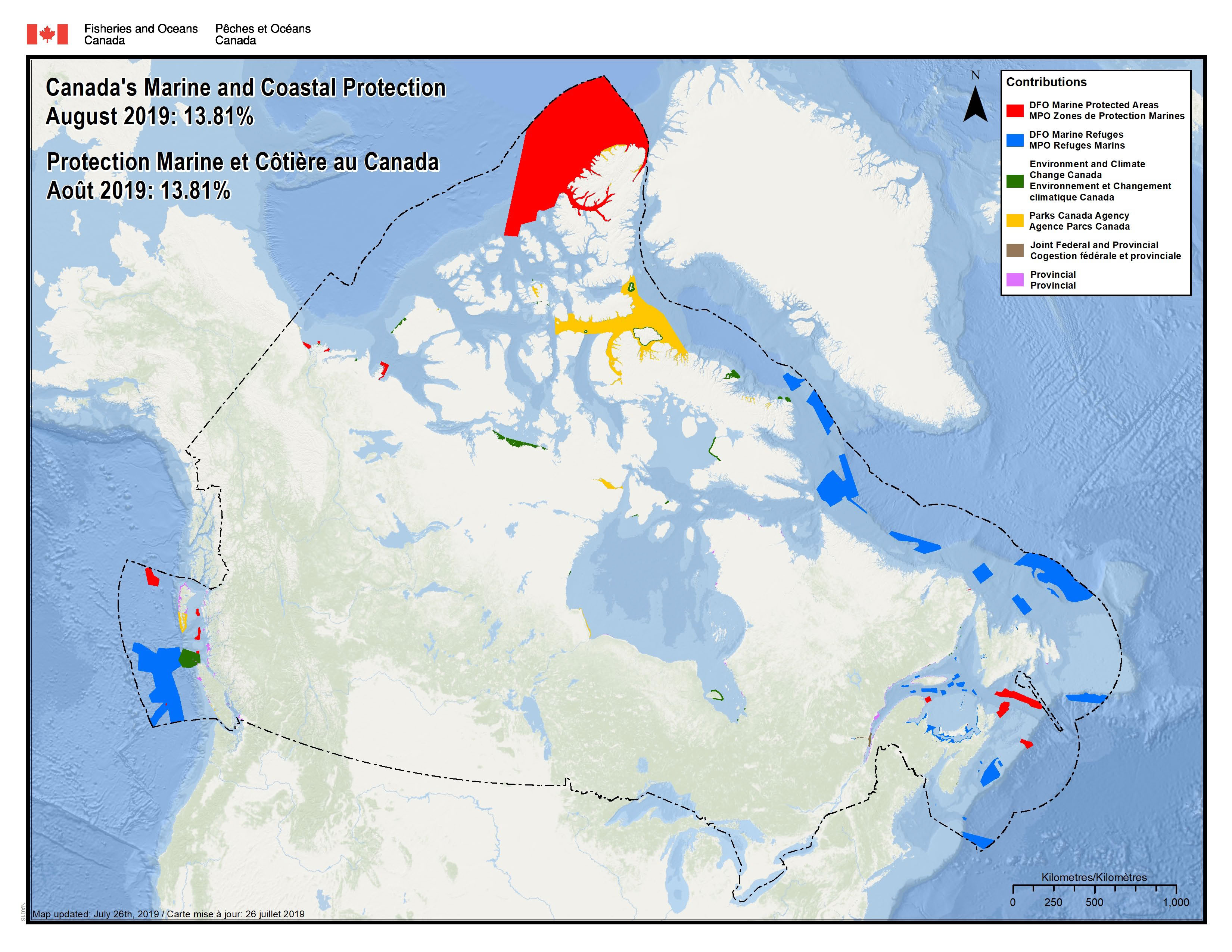
Canada’s Marine and Coastal Protection
August 2019: 13.81%
Annex B: Legislative and regulatory tools for establishing conserved areas
Fisheries and Oceans Canada
- Oceans Act MPAs
- Fisheries Act marine refuges
- Potentially additional OECMs
Environment and Climate Change Canada
- Marine National Wildlife Areas
- Marine portions of Migratory Bird Sanctuaries and National Wildlife Areas
Parks Canada Agency
- National Marine Conservation Areas
- Marine portions of National Parks
Provinces and territories
- Through their own legislative mechanisms
Indigenous Governments and Groups
- Potential for marine Indigenous Protected and Conserved Areas
Annex C: Current MSP planning areas
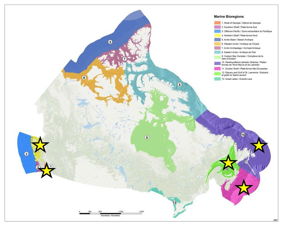
Description
This map illustrates 13 marine bioregions in Canada. These include:
- Strait of Georgia – an inland basin between Vancouver Island and Lower Mainland of British Columbia
- Southern Shelf – area off the west coast of Vancouver Island
- Offshore Pacific – area off the west coast of Vancouver Island, beyond the Southern Shelf
- Northern Shelf – extends from the top of Vancouver Island to the Canada-US border at Alaska
- Arctic Basin
- Western Arctic – covers the Inuvialuit Settlement Region and the Kitikmeot region of Nunavut
- Arctic Archipelago
- Eastern Arctic
- Hudson Bay Complex
- Newfoundland-Labrador Shelves
- Scotian Shelf – off the coast of Nova Scotia
- Estuary and Gulf of St. Lawrence
- Great Lakes
DFO plans to initiate Marine Spatial Planning (MSP) processes in five marine areas (indicated with a yellow star) in collaboration with other federal departments, provinces, territories, Indigenous peoples, and other stakeholders. These include: the Strait of Georgia, the Northern Shelf, Newfoundland-Labrador-Shelves, Scotian Shelf, and Estuary and Gulf of St. Lawrence.
In addition to the planning areas shown here similar activities are advancing in the Eastern Arctic (Pikialasorsuaq initiative) and Northern Labrador (Imappivut initiative).
- Date modified: