
Placentia Bay/Grand Banks Integrated Management Area
Location

Placentia Bay/Grand Banks Integrated Management Area
Geographically, the Placentia Bay – Grand Banks Integrated Management Area encompasses an area of approximately 550,000 square km ranging from the Laurentian Channel in the southwest to the Grand Banks in the east, and from the coastal baselines as defined by international law to the outer limits of the continental shelf. For the most part, the it consists of the Grand Banks of Newfoundland. The majority of the banks are between 51-100 m in depth with some areas of the banks reaching up to 200 m. On the Grand Banks the cold Labrador Current mixes with the warm Gulf Stream causing an upwelling of nutrients, creating a highly productive area with rich primary productivity and high species diversity. It is this productivity, paired with other available resources (e.g., oil and gas) and geographic location, which also inherently makes this area of the Newfoundland and Labrador region extremely distinctive in its support of human activities.
Integrated Management Plan
The Placentia Bay/Grand Banks (PB/GB) Integrated Management Plan (2012) [PDF] - 2.75 Mb is a multi-year, strategic level plan for the integrated management of policies, programs, plans, measures and activities in or affecting the PB/GB Integrated Management Area. The Plan is intended to provide long-term direction and a common basis for the development and implementation of action plans for environmental, social, cultural and economic sustainability.
The Plan follows an objectives-based management framework. Starting with a clear vision for safe and sustainable use of healthy oceans through effective and collaborative governance, the Plan aims to achieve three long-term, over-arching goals, as follows: collaborative and effective governance, healthy ecosystems, and sustainable use. These three goals provide the direction for developing underlying objectives, management strategies and management actions.
The Plan represents a shift from single species or single industry management to a broader, more inclusive method of ecosystem-based management for ocean and coastal activities. Management on an ecosystem scale acknowledges that the marine environment is a dynamic and evolving system composed of interdependent species and habitats and recognizes that human activities can have cumulative and far-reaching impacts on the environment. The Plan focuses on the overall management of the PB/GB Integrated Management Area to maintain integral aspects of ecosystem structure and function as well as social, cultural and economic well-being.
The State of the Ocean Report for Placentia Bay- Grand Banks Integrated Management Area
The ecosystem reported on in the Placentia Bay Grand Banks Large Ocean Management Area Report [PDF] - 660 kb is the designated integrated management area for the Newfoundland and Labrador Region. Geographically, the area encompasses approximately 550,000 km2, starting at Cape Ray on the island portion of the south coast (near Port aux Basques), continuing eastward along the south coast and extending northward along the east coast, as far north as Cape Freels at the tip of Bonavista Bay. The seaward boundaries correspond with the Northwest Atlantic Fisheries Organization's (NAFO) fisheries management divisions 3LNO and subdivisions 3Ps and 3Pn. The southern boundary of the integrated management area extends beyond the 200 nm limit of Canada's exclusive economic zone to the edge of the continental shelf, defined as 42° N latitude.
Priorities for Conservation
Several areas for priority conservation action have been identified within the Placentia Bay/Grand Banks area to date: Atlantic Cod, aquatic invasive species (AIS), habitat and corals and sponges. All three of the Atlantic Cod (Gadus morhua) stocks within the Placentia Bay/Grand Banks area declined significantly in the late 1980s and early 1990s.
Other highlights
The aquatic invasive species, Green crab (Carcinus maenas), was first observed in Placentia Bay in 2007, and in areas of high abundance have had a substantial impact on commercial and non-commercial mollusc and crustacean species and the natural environment. Mitigation by removal through intense trapping can be an effective method of reducing the abundance of green crab and limiting the impact the species has on the environment while other methods continue to be researched and tested.
The identification of ecologically significant species that provide structural habitats (e.g., corals and eelgrass), areas considered ecologically and biologically significant, as well as habitat characterization remain a priority to enhancing knowledge and protection of areas within the Placentia Bay/Grand Banks area that are important to the ecosystem structure and function.
Deep-sea corals have been identified as ecologically significant species within the ecosystems of the Placentia Bay/Grand Banks area as they provide unique structural habitat. At the same time, cold water sponges are increasingly being recognized as similarly important components of marine ecosystems through their provision of benthic habitat. Priority research areas for deep-sea corals based on areas of high biodiversity and abundance have been identified in the region and management measures targeting their protection are ongoing.
In regards to new sources of information addressing knowledge gaps within the Large Ocean Management Area, a 2007 aerial survey was conducted to accurately estimate the abundance and distribution of marine mammals, sea turtles and other surface megafauna with significant impacts for our understanding from a management and Species at Risk perspective.
For more information, please visit: Ecosystem Status and Trends Report for the Newfoundland and Labrador Shelf (CSAS resdocs - 2010/026) .

Cold water corals, attached to sedimentary rock of the Orphan Knoll seamount. This photo was taken by a remotely operated submersible (ROPOS). Photo: DFO

The green crab threatens to displace native species in the area. Photo: DFO

Eelgrass provides valuable structural habitat. Photo: DFO
Cold-Water Coral and Sponge Conservation in Canada
In Canada, corals and sponges are found in the Pacific, eastern Arctic, and Atlantic Oceans. Coral and sponge provide complex three dimensional habitat which is important for a variety of deep sea species.
Slow growth rates, longevity, and habitat-limiting factors make corals and sponges particularly vulnerable to physical impacts both directly and indirectly. Corals and sponges can be adversely affected by a broad range of impacts, many of which are associated with human activities including: fishing (e.g. bottom impact fishing), oil and gas exploration and development, and submarine cable and pipeline installation. Ocean acidification, as a result of climate change, is also impacting these species.
The responsibilities of countries to implement conservation measures for cold-water coral and sponges, are defined in international conventions and agreements such as the Convention on Biological Diversity and United Nations General Assembly Resolution (UNGA) 61/105.

Figure 1 Coral – Primnoa resedaeformis – Scotian Shelf, Atlantic Ocean

Figure 2 Coral – Paragorgia arborea – Scotian Shelf, Atlantic Ocean

Figure 3 Sponge – Mycale bellabellensis – Learmonth Bank, Pacific Ocean

Figure 4 Sponge – Mycale bellabellensis – Learmonth Bank, Pacific Ocean
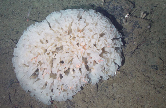
Figure 5 Sponge – Farrea occa – Learmonth Bank, Pacific Ocean

Figure 6 – Keratoisis grayi (=K. ornata) and Anthomastus sp. – Southwest Grand Banks, Atlantic Ocean

Figure 7 Primnoa resedaeformis (R), and Anthomastus sp. (L) – Scotian Shelf, Atlantic Ocean

Figure 8 Coral – Paragorgia johnsoni – Scotian Shelf, Atlantic Ocean

Figure 9 Coral – Anthomastus sp. (L), Octocoral sp. (purple/centre), Desmophyllum dianthus (R) – Scotian Shelf, Atlantic Ocean

Figure 10 Coral – Paragorgia arborea – Scotian Shelf, Atlantic Ocean

Figure 11 A variety of sponges – Learmonth Bank, Pacific Ocean
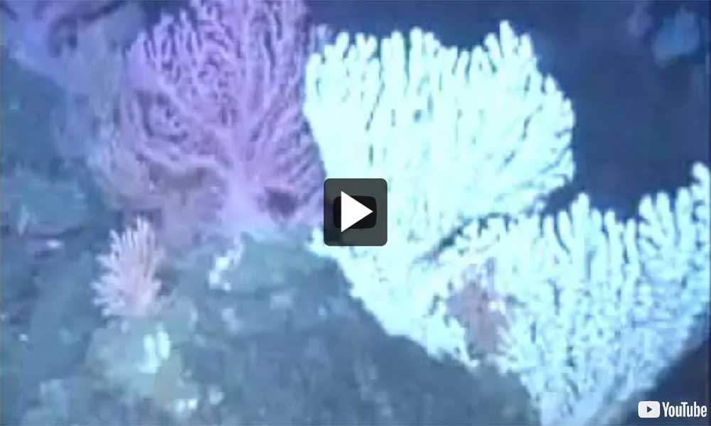
Video: Oasis of the Deep: Cold Water Corals of Atlantic Canada
Marine Protected Areas (MPAs) within the Placentia Bay/Grand Banks Integrated Management Area
Marine Protected Areas (MPAs) are geographically defined areas under the Oceans Act. They were established to protect and conserve important fish & marine mammal habitats, endangered marine species, unique features and areas of high biological productivity or biodiversity. Two MPAs are within the Placentia-Bay/Grand Banks Integrated Management Area.
Publications
- Coral & Sponge Conservation Strategy for Eastern Canada 2015
- Coral & Sponge Conservation Strategy for Eastern Canada 2015 [PDF] - 3.3 Mb
- Cold-Water Corals and Sponge Reefs
- Placentia Bay Grand Banks Large Ocean Management Area Report (2012) [PDF] - 660 kb
- 2010 Canadian Marine Ecosystem Status and Trends Report (CSAS SAR - 2010/030)
- Ecosystem Status and Trends Report for the Newfoundland and Labrador Shelf (2010) (CSAS resdocs - 2010/026)
- Status Report on Coral and Sponge Conservation in Canada (2009) [PDF] - 6 Mb
- The State of the Ocean Report for Placentia Bay - Grand Banks Large Ocean Management Area
- Date modified: