
Marine conservation network development
The Government of Canada is making important progress on its marine conservation network. Federal Marine Protected Area (MPA) legislated authorities including Fisheries and Oceans Canada, Parks Canada and Environment and Climate Change Canada are committed to working with provincial and territorial counterparts, First Nations and Indigenous organizations, industry and environmental non-governmental organizations to build a national network of MPAs and other conservation areas.
National
Canada's National Network
Canada's national network of MPAs will be composed of 13 networks that share a common foundation (vision, goals, principles, design and eligibility criteria, management approach, and so on). The 13 networks will be created in spatially-defined bioregions (CSAS SAR - 2009/056) that cover Canada's Exclusive Economic Zone (EEZ) and the Great Lakes. A bioregion is a biogeographic division of Canada's marine environment based on ecological attributes.
A Policy Framework for Canada's National Network of MPAs has been approved in principle. This document sets the policy direction for establishing a national network of MPAs that conforms to international best practices and targets conservation objectives identified through existing integrated oceans management processes.
MPAs and Integrated Management
Developing MPAs through an integrated management process widens the scope within which the MPA is considered. Integrated management provides an opportunity to address stakeholder input in a fair and balanced process, develop MPA conservation objectives with links to broader ecological, social, economic and cultural objectives and reinforce conservation measures with complementary management measures employed in surrounding areas. Including MPAs within broader planning initiatives can help maximize the conservation effectiveness and ensure the long term success of the MPA.
Pacific
Pacific Bioregional Network
A cooperative and collaborative approach is being implemented by Fisheries and Oceans Canada, the Province of British Columbia, Parks Canada, Environment Canada, and Natural Resources Canada for planning, establishing and managing marine protected areas in the Pacific.
DFO is working with the Marine Protected Areas Implementation Team (MPAIT) to develop a Regional MPA Strategy that will identify high-level objectives for all bioregions in the Pacific Region.
Canada-British Columbia Marine Protected Area Network Strategy
Gulf of St. Lawrence
Marine Protected Area Network Strategy for the Estuary and Gulf of St. Lawrence Bioregion
Introduction
The important role of marine protected area networks in providing long-term conservation of marine biodiversity, ecosystem functions and special natural features is reflected in provincial, territorial, national and international commitments made by various government authorities. Fisheries and Oceans Canada (DFO) is combining its efforts with those of other federal departments and the provinces (bordering the Estuary and Gulf of St. Lawrence) with mandates, expertise or interest in establishing marine protected areas. The Oceans Act states:
“For the purposes of integrated oceans management, the Minister (Fisheries and Oceans Canada) will lead and coordinate the development and implementation of a national system (network) of Marine Protected Areas.”
This task is carried out on behalf of the Government of Canada.
Aboriginal groups and interested parties will be engaged in a marine protected area network development covering the Estuary and Gulf of St. Lawrence Bioregion. This initiative contributes to the continuing implementation of the Gulf of St. Lawrence Integrated Management Plan published in 2013.
A platform for the coordination of efforts is needed at both national and regional levels. Wherever possible, the existing governance structures will be utilised. The various departments, each with different mandates, conservation measures and legal statutes, will be involved in network development. It is therefore necessary to establish a common basis for achieving the network objectives in a coordinated, coherent and effective way.
This strategy is developed as a guiding framework, designed to provide a comprehensive understanding for partners involved in the development of a Marine Protected Area Network in the Estuary and Gulf of St. Lawrence Bioregion. It outlines the guidance needed to establish a marine protected area network in accordance with national and international recommendations and practiceswhile incorporating the visions and goals of the provinces and the Government of Canada. The strategy is also designed to standardize and clarify terminology and harmonize the various approaches to developing the marine protected area network.
The initialisms and acronyms used are presented at the beginning of this document, and key terms are defined in the glossary (Appendix 1).
For more information, please visit: Marine Protected Area Network Strategy for the Estuary and Gulf of St. Lawrence Bioregion
Scotian Shelf-Bay of Fundy
Marine conservation network development for the Scotian Shelf-Bay of Fundy Bioregion
A marine conservation network plan has been created for the coastal and offshore waters of the Scotian Shelf-Bay of Fundy Bioregion. This conservation network plan is an important part of marine spatial planning in the region and will be periodically updated to guide regional spatial marine conservation work for years to come.

Map of the Scotian Shelf-Bay of Fundy Bioregion (depicted using DFO Maritimes Region boundary)
Explore our interactive map with existing and potential network sites in the bioregion.
On this page
- Importance of marine conservation networks
- Creating a network in Scotian Shelf-Bay of Fundy Bioregion
- Next steps: Finalizing the network plan for 2024
- Contact us
- Related information
Importance of marine conservation networks
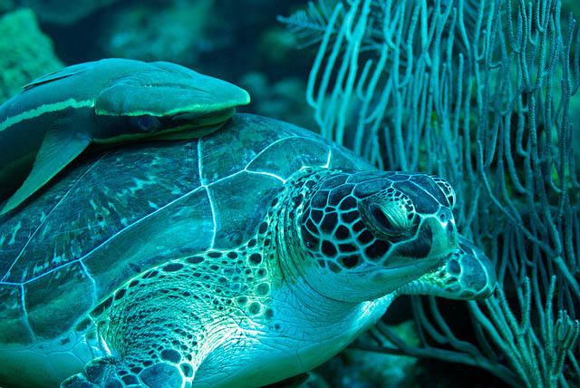
Oceans are under increasing pressure from human uses and environmental changes. Around the world, MPAs and other effective area-based conservation measures, such as marine refuges, help protect our oceans.
Marine conservation networks are a collection of individual conservation areas. These areas are connected by species movements and other ecological processes. Together, networks offer greater protection to Canada's marine species, habitats and ecosystems. Networks support conservation over the long term, while also aiming to minimize impacts on ocean users.
Creating a network in Scotian Shelf-Bay of Fundy Bioregion
The conservation network plan is being created with Environment and Climate Change Canada and Parks Canada, and with input from provinces, First Nations and Indigenous organizations, stakeholders and the public.
The conservation network includes individual sites with different shapes, sizes and protection levels. Each site has its own conservation objectives. National minimum protection standards prohibit 4 industrial activities:
- oil and gas activities
- mining
- dumping
- bottom trawling
Sites will be determined through separate site-specific processes with additional consultations. Every network site is unique. Some types of fishing and low-impact activities, such as eco-tourism and recreational boating, can often continue.
The marine conservation network plan will guide the selection of new MPAs and other effective area-based conservation measures, such as marine refuges, in the bioregion. Regional sites will support our national goal of protecting 30% of Canada's coastal and marine areas by 2030. Using a network plan is more efficient and provides greater certainty to ocean users.
Learn more about the approach used to create the marine conservation network.
Next steps: Finalizing the network plan for 2024
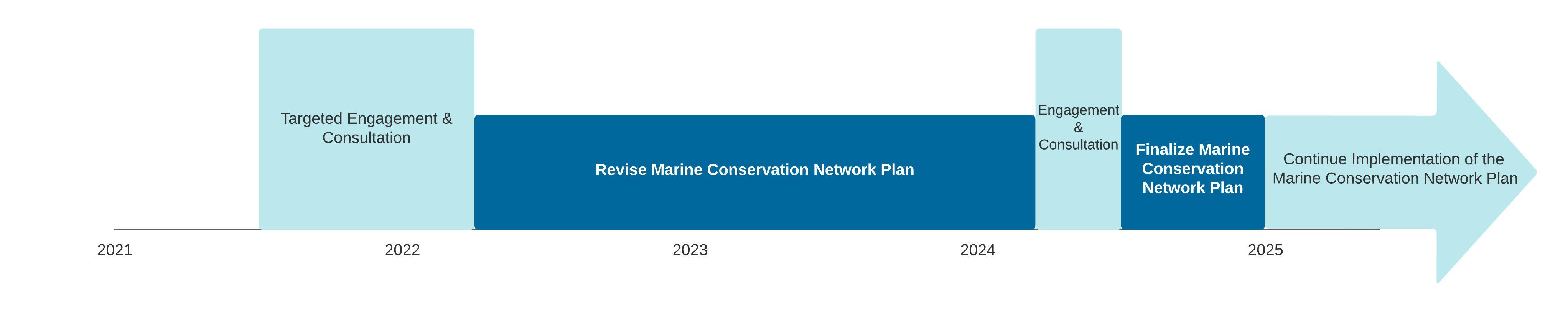
Timeline for the marine conservation network plan for the Scotian Shelf-Bay of Fundy Bioregion.
The department completed targeted engagement for the network plan on March 31, 2022. DFO received feedback on the initial design from federal agencies, provinces, First Nations and Indigenous organizations and stakeholders. Stakeholders included:
- fishing
- aquaculture
- oil and gas industries
- shipping industries
- environmental non-government organizations
- academia
The department reviewed this feedback and shared a summary of the feedback with partners and stakeholders. Revisions were made based on this feedback from consultations and recent science guidance.
The department will start broader engagement in early 2024. DFO will seek further feedback from coastal communities, partners, stakeholders and the public. Feedback will be incorporated as appropriate to finalize a marine conservation network plan for the Scotian Shelf-Bay of Fundy Bioregion.
After the network plan is finalized in 2024, it will be adapted as needed based on any new information. Implementation of the network plan, including the designation of individual sites, will occur over the long term.
Contact us
Marine Planning and Conservation Program
Fisheries and Oceans Canada
MaritimesMPAs@dfo-mpo.gc.ca
Related information
- Date modified: