
Aspy Bay
Aspy Bay is proposed as a Tier 2 site for the Marine Conservation Network in the Scotian Shelf-Bay of Fundy Bioregion.
On this page
Location
Aspy Bay is located off the northern coast of Cape Breton. It spans the coast from White Point to Pollys Brook and includes North Harbour, Middle Harbour, and South Harbour.
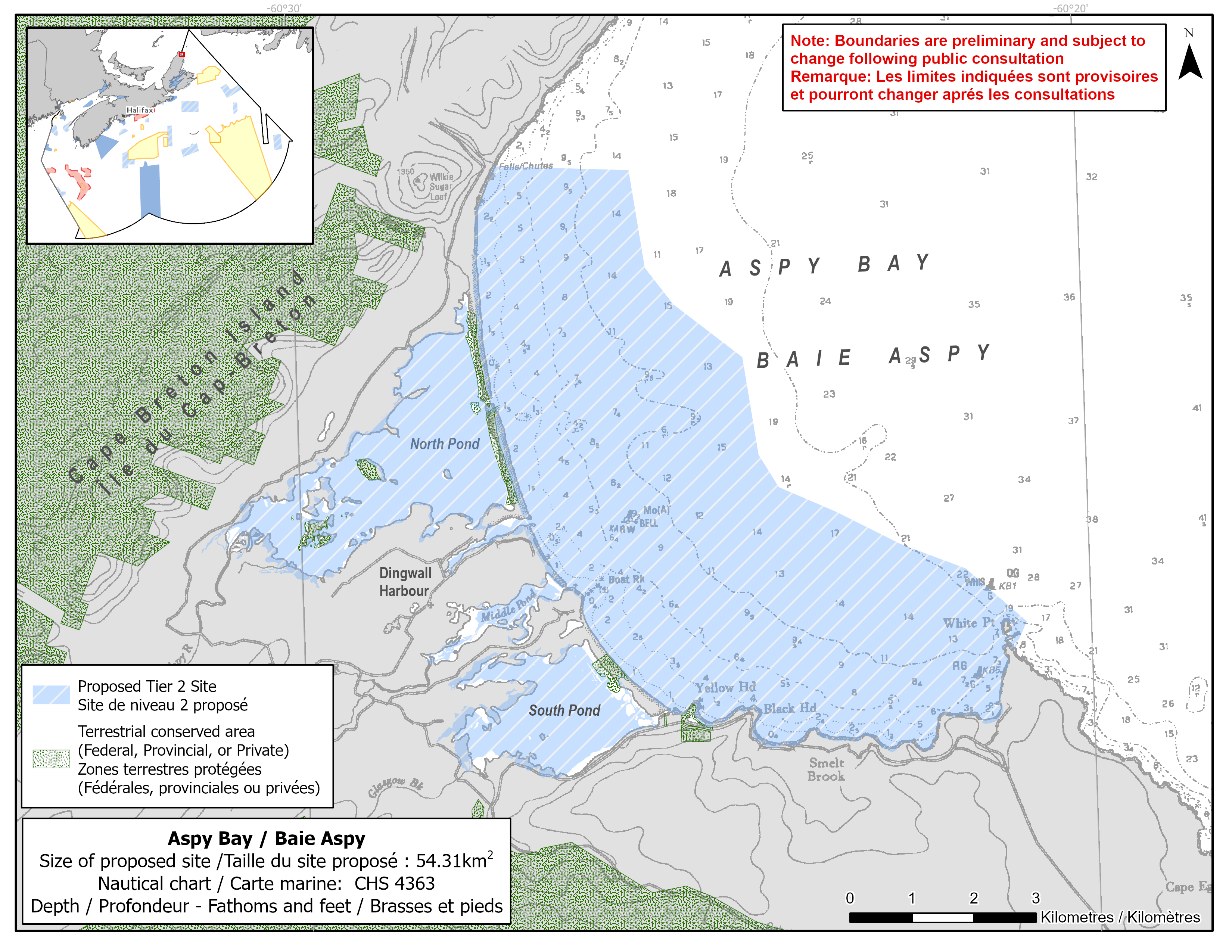
Map of proposed Aspy Bay network site
Simplified site coordinates
Boundaries are preliminary and subject to change following the public engagement.
| Point | Latitude | Longitude | Description |
|---|---|---|---|
| 1 | 46°57' 22.527" N | 60°27' 23.599" W | Starting at point 1 on the coastline, in the northwest of the site |
| 2 | 46°57' 18.265" N | 60°25' 41.276" W | Connect to point 2, east of point 1 |
| 3 | 46°56' 27.030" N | 60°25' 31.318" W | Connect to point 3, south of point 2 |
| 4 | 46°55' 38.640" N | 60°24' 19.177" W | Connect to point 4, southeast of point 3 |
| 5 | 46°54' 47.404" N | 60°24' 9.245" W | Connect to point 5, south of point 4 |
| 6 | 46°54' 30.067" N | 60°23' 54.576" W | Connect to point 6, southeast of point 5 |
| 7 | 46°53' 44.341" N | 60°21' 34.157" W | Connect to point 7, southeast of point 6 |
| 8 | 46°53' 15.666" N | 60°20' 49.062" W | Connect to point 8, southeast of point 7 |
| 9 | 46°53' 0.545" N | 60°20' 59.528" W | Connect to point 9 on the coastline, southwest of point 8 and follow along the coastline to connect point 9 to point 1 |
Size
54 km2
Features
- Feeding area for whales
- Important foraging area for seabirds and shorebirds
- Significant concentrations of salt marsh and marine plants
- Overwintering area for Atlantic herring
- Important spawning river for Atlantic salmon drains into Aspy Bay
- Identified as an Important Bird Area
- Nearby terrestrial protection, including:
- Polletts Cove – Aspy Fault Wilderness Area
- Yellow Head Conservation Lands
- Critical habitat for piping plover
- High productivity due to lagoons
Species
This area supports species including:
- Cetaceans, such as:
- Fin whale (listed as special concern under SARA)
- Humpback whale
- Minke whale
- Pilot whale
- Eastern Cape Breton Atlantic salmon (assessed as endangered by COSEWIC)
- Atlantic herring
- Seabirds and shorebirds, such as:
- Piping plover (listed as endangered under SARA)
- Great blue heron
- Salt marsh, kelp and eelgrass
Use
- Current fisheries include crab, groundfish (fixed gear), lobster, herring (fixed gear) and mackerel.
- Shellfish harvesting occurs in the area.
- There is a moratorium on fishing cod and haddock on the Eastern Scotian Shelf.
- Licences issued to First Nations and Indigenous communities provide access to this area to fish for food, social and ceremonial purposes.
- There are several shellfish aquaculture leases in the site.
- Recreational activities include:
- hiking
- beachgoing
- whale watching
- Date modified: