
Bras d’Or Lake
Bras d’Or Lake is proposed as a Tier 1 site for the Marine Conservation Network in the Scotian Shelf-Bay of Fundy Bioregion.
Potential Bras d’Or Lake conservation network sites will be determined with Unama’ki Institute of Natural Resources.
On this page
Location
Bras d’Or Lake is a large inland sea on Cape Breton Island.
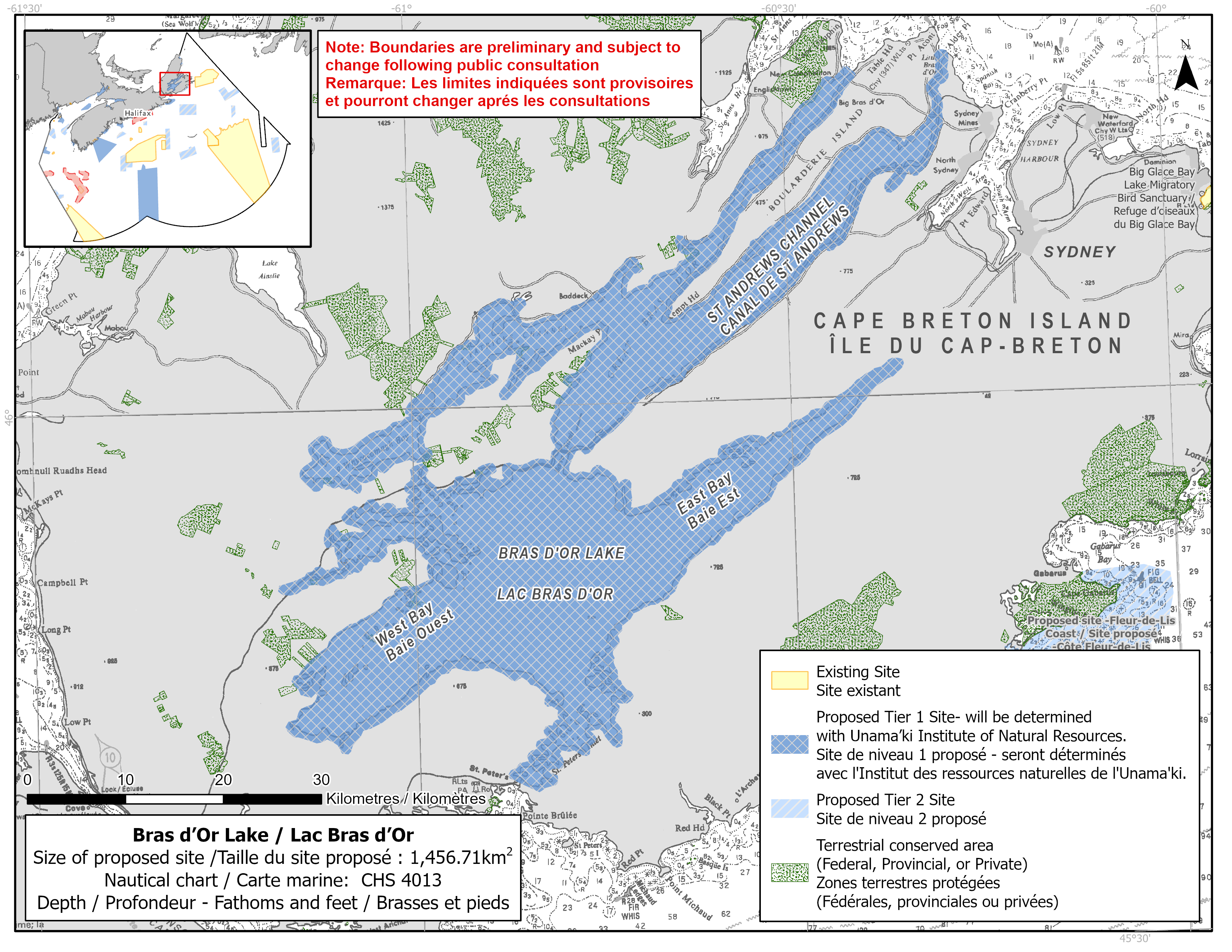
Map of proposed Bras d’Or Lake network site
Simplified site coordinates
Boundaries are preliminary and subject to change following the public engagement.
Bras d'Or Lakes proposed site was created by buffering the edge of the lake by 500m inland.
| Point | Latitude | Longitude | Description |
|---|---|---|---|
| 1 | 46°18' 13.363" N | 60°25' 0.592" W | Starting at point 1 at the mouth of the Bras D'Or Lake |
| 2 | 46°18' 10.870" N | 60°24' 42.992" W | Connect to point 2, east of point 1 |
| 3 | 46°17' 49.608" N | 60°24' 6.084" W | Connect to point 3, southeast of point 2 |
| 4 | 46°17' 40.194" N | 60°24' 2.179" W | Connect to point 4 at the mouth of the Bras D'Or Lake, south of point 3 |
| 5 | 46°18' 45.223" N | 60°17' 43.226" W | Follow along the buffered lake edge to point 5 at the mouth of St Andrews Channel |
| 6 | 46°18' 52.944" N | 60°17' 37.664" W | Connect to point 6, northeast of point 5 |
| 7 | 46°18' 52.783" N | 60°16' 48.716" W | Connect to point 7, east of point 6 |
| 8 | 46°18' 44.143" N | 60°16' 39.652" W | Connect to point 8 at the mouth of St Andrews Channel, southeast of point 7 and follow along the buffered lake edge to connect point 8 to point 1 |
Size
1 457 km2
Features
- Cultural significance for the Mi'kmaq communities of Unama'ki (Cape Breton)
- Provincially significant numbers of nesting bald eagles
- Important concentrations of salt marsh and marine plants
- Distinct marine algae including regionally rare species
- Spawning habitat for Eastern Cape Breton Atlantic salmon and Atlantic herring
- Identified as an Important Bird Area and watershed designated as a UNESCO Biosphere Reserve
- Nearby terrestrial protection, including:
- Spectacle Island Game Sanctuary
- Washabuck River Nature Reserve
- Mary Harper Nature Reserve
- MacDonalds Pond Nature Reserve
- Seal Cove Nature Reserve
- Humes River Wilderness Area
- Kluskap Wilderness Area (shared governance with Mi'kmaq of Nova Scotia)
- Whycocomagh Provincial Park
- Groves Point Provincial Park
- Barrachois Provincial Park
- Ben Eoin Provincial Park
- Battery Provincial Park
- Unique oceanographic characteristics, including steep temperature changes, stratification (distinct horizontal water layers), and limited exchange with the open oceans, supports relict warm and cold water species.
- Unique inland estuarine ecosystem
Species
- American oyster beds
- Polychaete worms
- Eastern Cape Breton Atlantic salmon (assessed as endangered by COSEWIC)
- Atlantic herring
- Alewife, mackerel and three-spined stickleback
- Depleted groundfish, such as:
- Atlantic cod (assessed as endangered by COSEWIC)
- American plaice (assessed as threatened by COSEWIC)
- Winter skate (assessed as threatened by COSEWIC)
- White hake (assessed as threatened by COSEWIC)
- Seabirds and shorebirds, such as:
- Barrow's goldeneye (listed as special concern under SARA)
- Herons
- Salt marsh, eelgrass and marine algae
Use
- The Bras d'Or Lake watershed is home to five First Nations. A Traditional Ecological Knowledge workshop sponsored by the Bras d'Or Lake Collaborative Environmental Planning Initiative (CEPI) identified 40 sites of cultural, social and recreational significance within the watershed.
- Fisheries include crab, groundfish (fixed gear), lobster and scallop.
- Shellfish harvesting occurs in the area.
- Licences issued to First Nations and Indigenous communities provide access to this area to fish for food, social and ceremonial purposes.
- There are finfish and shellfish aquaculture leases in the site.
- Recreational fisheries include eel, mackerel, smelt and Atlantic salmon (catch and release only).
- Recreational activities include:
- boating
- sailing
- beachgoing
- Coastal development, forestry and mining occur in the watershed.
- Some shipping traffic from mining operations and a small cable ferry.
- Date modified: