
Brier Island
Brier Island is proposed as a Tier 2 site for the Marine Conservation Network in the Scotian Shelf-Bay of Fundy Bioregion.
On this page
Location
Brier Island includes the waters south and west of Long Island and Brier Island extending into the Gulf of Maine. It also encompasses the Northwest Ledge and Brier Island Southwest Ledge.
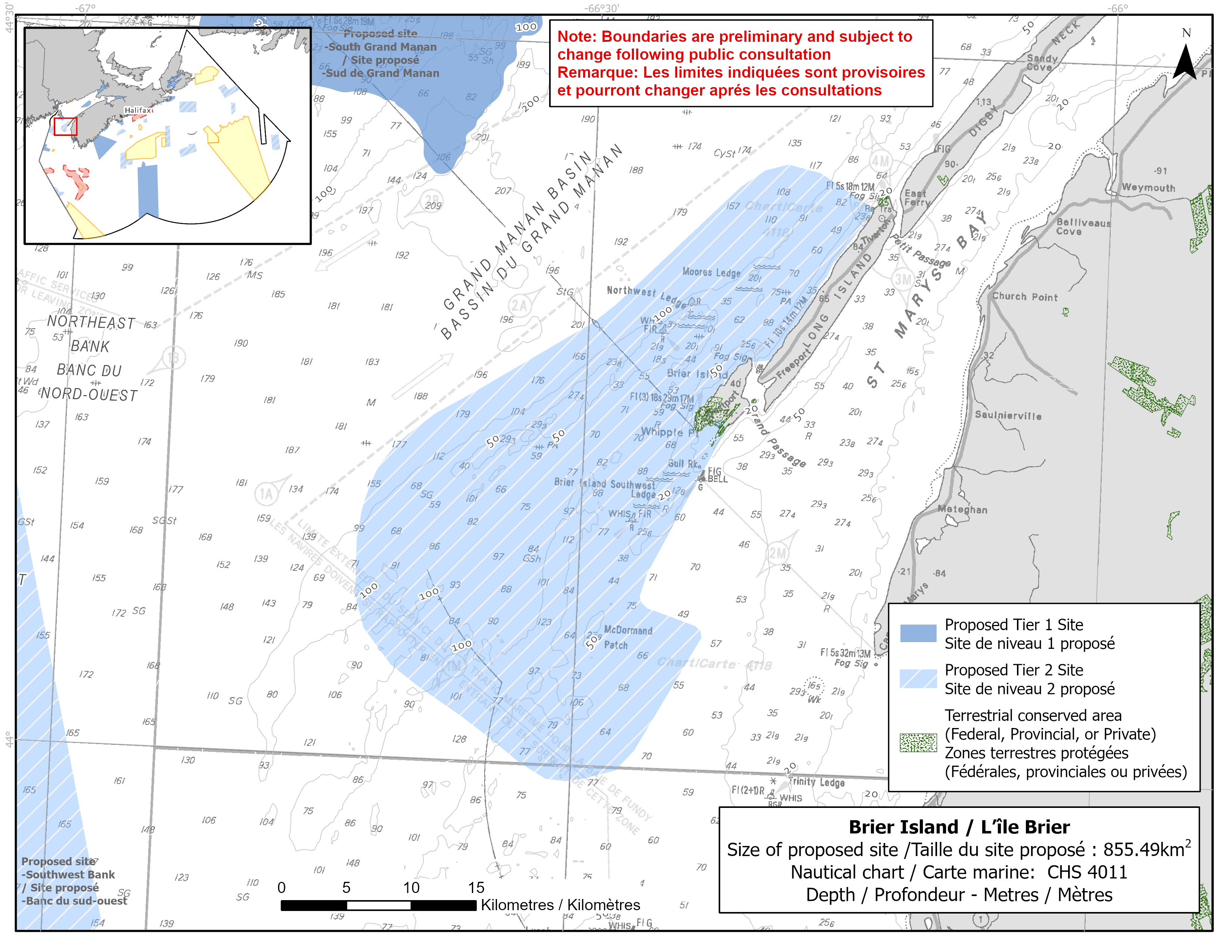
Map of proposed Brier Island network site
Simplified site coordinates
Boundaries are preliminary and subject to change following the public engagement.
| Point | Latitude | Longitude | Description |
|---|---|---|---|
| 1 | 44°23' 38.2" N | 66°13' 46.4" W | Starting at point 1 on the coastline of Long Island |
| 2 | 44°17' 10.0" N | 66°19' 27.3" W | Follow along Long Island coastline southwest to connect to point 2 |
| 3 | 44°17' 3.2" N | 66°20' 31.7" W | Connect to point 3, east of point 2 |
| 4 | 44°14' 23.2" N | 66°21' 40.8" W | Follow along Brier Island coastline southwest to connect to point 4 |
| 5 | 44°7' 7.6" N | 66°26' 23.1" W | Connect to point 5, southwest of point 4 |
| 6 | 44°6' 38.5" N | 66°25' 54.3" W | Connect to point 6, southeast of point 5 |
| 7 | 44°5' 59.8" N | 66°23' 7.6" W | Connect to point 7, east of point 6 |
| 8 | 44°5' 31.6" N | 66°22' 43.0" W | Connect to point 8, southeast of point 7 |
| 9 | 43°59' 50.9" N | 66°27' 23.3" W | Connect to point 9, southwest of point 8 |
| 10 | 43°59' 27.0" N | 66°29' 10.8" W | Connect to point 10, west of point 9 |
| 11 | 43°59' 23.0" N | 66°31' 22.3" W | Connect to point 11, west of point 10 |
| 12 | 44°5' 19.7" N | 66°42' 14.0" W | Connect to point 12, northwest of point 11 |
| 13 | 44°9' 1.0" N | 66°42' 51.7" W | Connect to point 13, north of point 12 |
| 14 | 44°11' 48.2" N | 66°41' 56.9" W | Connect to point 14, north of point 13 |
| 15 | 44°13' 26.7" N | 66°40' 11.8" W | Connect to point 15, northeast of point 14 |
| 16 | 44°15' 19.4" N | 66°36' 27.7" W | Connect to point 16, northeast of point 15 |
| 17 | 44°18' 27.1" N | 66°29' 42.4" W | Connect to point 17, northeast of point 16 |
| 18 | 44°24' 20.7" N | 66°21' 28.9" W | Connect to point 18, northeast of point 17 |
| 19 | 44°25' 3.4" N | 66°20' 6.6" W | Connect to point 19, northeast of point 18 |
| 20 | 44°25' 20.4" N | 66°18' 47.1" W | Connect to point 20, northeast of point 19 |
| 21 | 44°25' 1.9" N | 66°16' 53.4" W | Connect to point 21, southeast of point 20 and connect point 21 to point 1 |
Size
855 km2
Features
- Significant concentrations of sponges
- Feeding area for whales, dolphins and porpoises
- Important foraging area for seabirds, sea ducks and shorebirds
- Significant concentrations of marine plants
- Spawning area for pollock, haddock and Atlantic cod
- Important habitat for several depleted groundfish
- High benthic invertebrate, fish, marine mammal and bird diversity
- Nearby terrestrial protection including a nearby private land easement managed for conservation
- High secondary productivity with large concentrations of copepods and krill
- Strong tidal currents
Species
This area supports species, including:
- Cetaceans, such as:
- North Atlantic right whale (listed as endangered under SARA)
- Fin whale (listed as special concern under SARA)
- Harbour porpoise (assessed as special concern by COSEWIC)
- Humpback whale
- Minke whale
- Sei whale
- Atlantic white-sided dolphin
- Depleted groundfish populations, such as:
- Atlantic cod (assessed as endangered by COSEWIC)
- Atlantic wolffish (listed as special concern under SARA)
- White hake (assessed as threatened by COSEWIC)
- Thorny skate (assessed as special concern by COSEWIC)
- Seabirds, sea ducks and shorebirds, such as:
- Roseate Tern (listed as endangered under SARA)
- Harlequin duck (listed as special concern under SARA)
- Red-necked phalarope (listed as special concern under SARA)
- Sponges
- Kelp, rockweed and unique seaweed species (Eudesme virescens, Desmotrichium undulatum, and Myrionema strangulans)
- Copepods and krill
Use
- Current fisheries include bluefin tuna, crab, groundfish (fixed and mobile gear), hagfish, herring (fixed and mobile gear), lobster, mackerel, scallop and sea urchin.
- Blood worm and seaweed harvesting also occur in the area.
- Licences issued to First Nations and Indigenous communities provide access to this area to fish for food, social and ceremonial purposes.
- Recreational activities include:
- sea kayaking
- bird and whale watching
- recreational fishing like clam harvesting
- Date modified: