
Canso Ledges-Sugar Harbour Islands
Canso Ledges-Sugar Harbour Islands is proposed as a Tier 1 site for the Marine Conservation Network in the Scotian Shelf-Bay of Fundy Bioregion.
The lead agency for this site is Fisheries and Oceans Canada.
On this page
Location
Canso Ledges-Sugar Harbour Islands includes the waters around the Canso Peninsula, from Sugar Harbour Islands south of the peninsula to Fox Bay on the northern portion of the peninsula. It also extends into Chedabucto Bay.
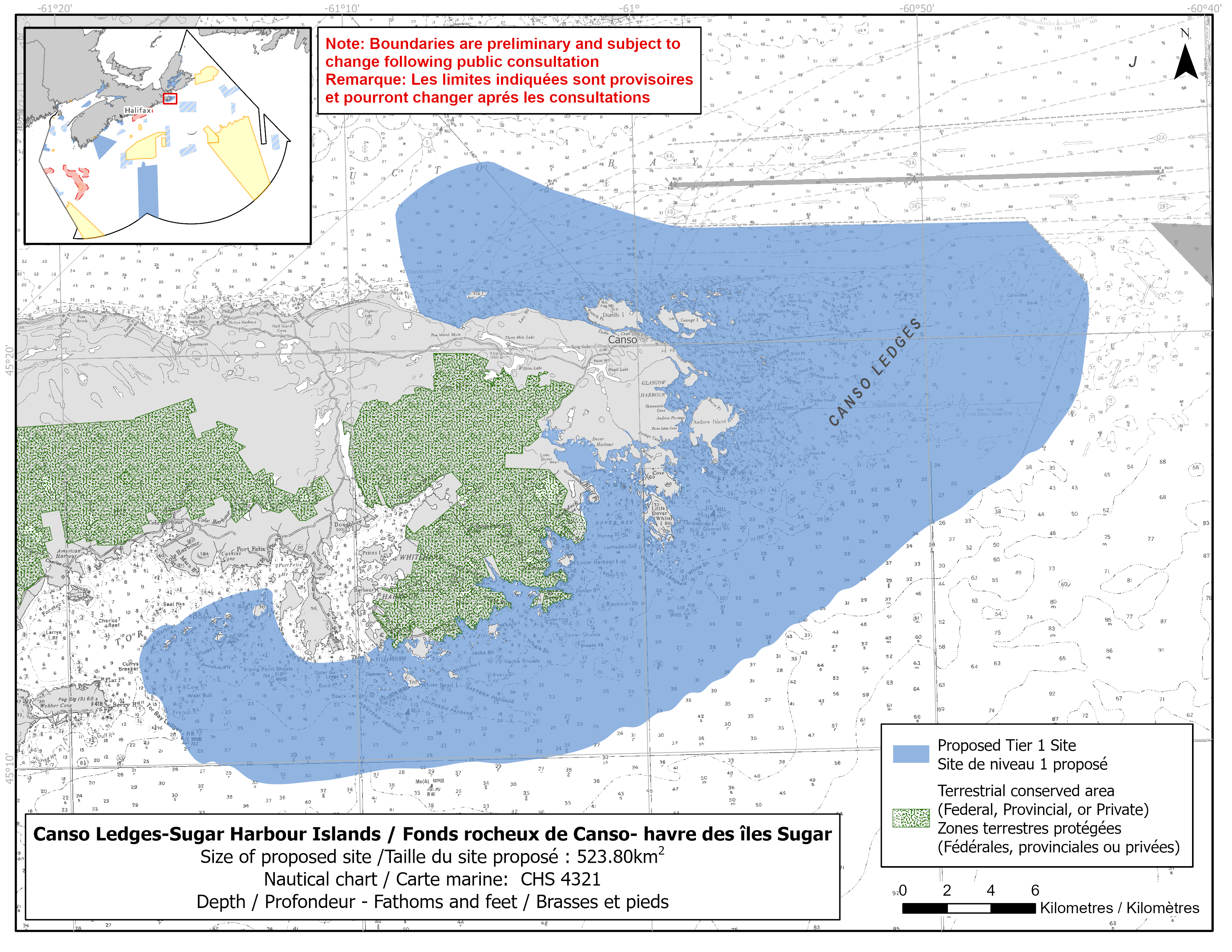
Map of proposed Canso Ledges-Sugar Harbour Islands network site
Simplified site coordinates
Boundaries are preliminary and subject to change following the public engagement.
| Point | Latitude | Longitude | Description |
|---|---|---|---|
| 1 | 45°20' 55.3" N | 61°7' 32.7" W | Starting at point 1 on the coastline near Fox Bay |
| 2 | 45°23' 22.1" N | 61°8' 18.6" W | Connect to point 2, north of point 1 |
| 3 | 45°23' 43.8" N | 61°7' 57.1" W | Connect to point 3, northeast of point 2 |
| 4 | 45°24' 36.1" N | 61°5' 15.9" W | Connect to point 4, northeast of point 3 |
| 5 | 45°24' 35.1" N | 61°4' 50.3" W | Connect to point 5, east of point 4 |
| 6 | 45°22' 53.1" N | 60°58' 20.1" W | Connect to point 6, southeast of point 5 |
| 7 | 45°22' 48.6" N | 60°46' 22.0" W | Connect to point 7, east of point 6 |
| 8 | 45°21' 14.1" N | 60°44' 20.2" W | Connect to point 8, southeast of point 7 |
| 9 | 45°18' 47.6" N | 60°44' 41.3" W | Connect to point 9, south of point 8 |
| 10 | 45°17' 25.6" N | 60°45' 52.2" W | Connect to point 10, southwest of point 9 |
| 11 | 45°10' 13.2" N | 61°2' 1.1" W | Connect to point 11, southwest of point 10 |
| 12 | 45°9' 51.7" N | 61°4' 58.6" W | Connect to point 12, west of point 11 |
| 13 | 45°9' 32.6" N | 61°11' 23.1" W | Connect to point 13, west of point 12 |
| 14 | 45°9' 31.6" N | 61°13' 24.6" W | Connect to point 14, west of point 13 |
| 15 | 45°9' 56.2" N | 61°14' 24.7" W | Connect to point 15, northwest of point 14 |
| 16 | 45°10' 2.0" N | 61°15' 18.1" W | Connect to point 16, west of point 15 |
| 17 | 45°10' 30.4" N | 61°16' 2.4" W | Connect to point 17, northwest of point 16 |
| 18 | 45°10' 58.2" N | 61°16' 33.9" W | Connect to point 18, northwest of point 17 |
| 19 | 45°11' 42.9" N | 61°16' 59.2" W | Connect to point 19, northwest of point 18 |
| 20 | 45°11' 47.6" N | 61°17' 16.4" W | Connect to point 20, west of point 19 |
| 21 | 45°12' 35.4" N | 61°17' 32.2" W | Connect to point 21, north of point 20 |
| 22 | 45°13' 19.8" N | 61°16' 57.2" W | Connect to point 22, northeast of point 21 |
| 23 | 45°13' 26.8" N | 61°16' 38.0" W | Connect to point 23, northeast of point 22 |
| 24 | 45°13' 26.1" N | 61°16' 14.0" W | Connect to point 24, east of point 23 |
| 25 | 45°13' 40.1" N | 61°15' 46.2" W | Connect to point 25, northeast of point 24 |
| 26 | 45°14' 13.5" N | 61°13' 44.0" W | Connect to point 26, northeast of point 25 |
| 27 | 45°14' 16.2" N | 61°13' 0.3" W | Connect to point 27, northeast of point 26 |
| 28 | 45°14' 8.6" N | 61°12' 51.5" W | Connect to point 28, southeast of point 27 |
| 29 | 45°13' 39.2" N | 61°12' 48.9" W | Connect to point 29, south of point 28 |
| 30 | 45°12' 31.2" N | 61°11' 51.4" W | Connect to point 30, southeast of point 29 |
| 31 | 45°12' 26.0" N | 61°11' 17.7" W | Connect to point 31, east of point 30 |
| 32 | 45°12' 35.4" N | 61°9' 46.5" W | Connect to point 32, east of point 31 |
| 33 | 45°12' 37.4" N | 61°9' 40.5" W | Follow along three top Island coastline southeast to point 33 |
| 34 | 45°12' 49.7" N | 61°9' 15.5" W | Connect to point 34 on the mainland coastline near Spry point, northeast of point 33 and follow the mainland coastline east to connect point 34 to point 1 |
Size
524 km2
Features
- Feeding area for whales, dolphins and porpoises
- Important foraging area for seabirds, sea ducks and shorebirds
- Significant concentrations of marine plants
- Overwintering area for Atlantic herring
- Juvenile/nursery area for sand lance and grubby
- Area of high fish and invertebrate diversity
- Nearby terrestrial protections, including:
- Canso Coastal Barrens Wilderness Area
- Sugar Harbour Islands Nature Reserve
- several protected beaches
- Black Duck Cove Provincial Park
- Andrews Island Provincial Park
- Canso Islands National Historic Site
- Area of high productivity
- Unique bay in size and depth
Species
This area supports species, including:
- Cetaceans, such as:
- Fin whale (listed as special concern under SARA)
- Harbour porpoise (assessed as special concern by COSEWIC)
- Minke whale
- Atlantic white-sided dolphin
- White-beaked dolphin
- Atlantic herring, sand lance and grubby
- Depleted groundfish populations, such as:
- Atlantic cod (assessed as endangered by COSEWIC)
- Winter skate (assessed as endangered by COSEWIC)
- Atlantic wolffish (listed as special concern under SARA)
- Thorny skate (listed as special concern under SARA)
- Seabirds, sea ducks and shorebirds, such as:
- Roseate Tern (listed as endangered under SARA)
- Harlequin duck (listed as special concern under SARA)
- Rockweed
Use
- Current fisheries include bluefin tuna, crab, groundfish, hagfish, lobster, mackerel, scallop and shrimp (mostly fixed gear).
- There is a moratorium on fishing cod and haddock on the Eastern Scotian Shelf.
- There was an important winter purse seine fishery for herring, though this has not been active in recent years.
- Licences issued to First Nations and Indigenous communities provide access to this area to fish for food, social, and ceremonial purposes.
- Recreation activities include:
- kayaking
- hiking
- beach going
- The site is near the main shipping lanes to the Strait of Canso Superport.
- The site is also near a planned marine terminal at the proposed quarry at Black Point.
- New green hydrogen and ammonia facilities and a marine cargo terminal have been proposed for the Strait of Canso area.
- Date modified: