
Central Scotian Slope, Rise, and Abyss
Central Scotian Slope, Rise and Abyss is proposed as a Tier 1 site for the Marine Conservation Network in the Scotian Shelf-Bay of Fundy Bioregion.
The lead agency for this site is Fisheries and Oceans Canada.
On this page
Location
Central Scotian Slope, Rise and Abyss is located approximately 200 km south of Halifax, Nova Scotia. The site starts on the edge of the Scotian Shelf and extends into the deep water of the abyssal plain at the extent of Canada's Exclusive Economic Zone.
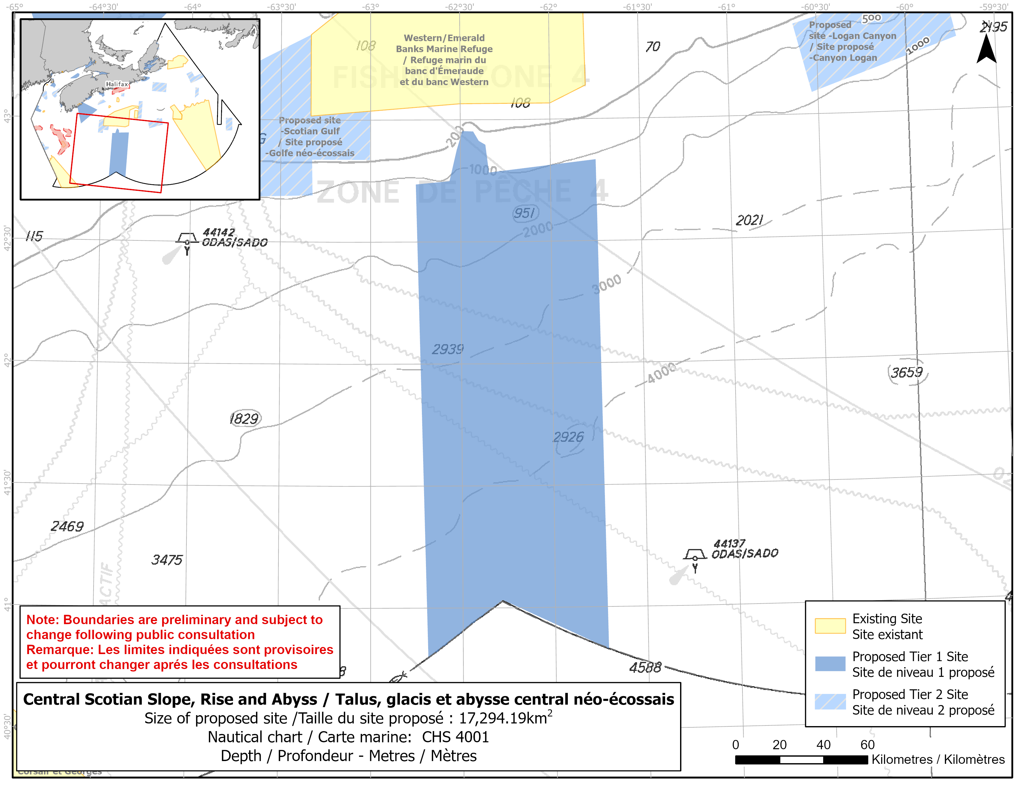
Map of proposed Central Scotian Slope, Rise and Abyss network site
Simplified site coordinates
Boundaries are preliminary and subject to change following the public engagement.
| Point | Latitude | Longitude | Description |
|---|---|---|---|
| 1 | 42°44' 12.4" N | 62°44' 56.4" W | Starting at point 1 on the northwest side of the site |
| 2 | 42°44' 58.6" N | 62°33' 42.2" W | Connect to point 2, east of point 1 |
| 3 | 42°57' 16.5" N | 62°29' 20.2" W | Connect to point 3, northeast of point 2 |
| 4 | 42°57' 10.3" N | 62°25' 42.8" W | Connect to point 4, east of point 3 |
| 5 | 42°54' 50.7" N | 62°23' 51.9" W | Connect to point 5, southeast of point 4 |
| 6 | 42°53' 53.3" N | 62°21' 39.3" W | Connect to point 6, southeast of point 5 |
| 7 | 42°47' 3.0" N | 62°20' 31.2" W | Connect to point 7, south of point 6 |
| 8 | 42°50' 2.6" N | 61°44' 52.4" W | Connect to point 8, east of point 7 |
| 9 | 40°49' 40.9" N | 61°42' 49.2" W | Connect to point 9, south of point 8 |
| 10 | 41°1' 59.5" N | 62°17' 8.5" W | Connect to point 10, southwest of point 9 |
| 11 | 40°47' 35.8" N | 62°41' 18.1" W | Connect to point 11, northwest of point 10 and connect point 11 to point 1 |
Size
17 294 km2
Features
- High abundance of sea pens, as this site includes a feature known as the Feather Peak
- Important habitat for depleted groundfish species
- Area of high fish and invertebrate diversity
- Western/Emerald Banks Marine Refuge is about 10 km to the north
- Representative example of the Eastern and Western Scotian slope, continental rise and abyssal plain habitats
Species
This area supports species, including:
- Depleted groundfish populations, such as:
- Cusk (assessed as endangered by COSEWIC)
- Roundnose grenadier (assessed as endangered by COSEWIC)
- Roughhead grenadier
- Sea pens and small gorgonian corals
Use
- Current fisheries include crab, groundfish (fixed and mobile gear), herring (mobile gear), lobster, scallop, swordfish and tuna.
- There is currently a moratorium on fishing Atlantic cod and haddock on the Eastern Scotian Shelf.
- Licences issued to First Nations and Indigenous communities provide access to this area to fish for food, social and ceremonial purposes.
- Moderate shipping traffic.
- Date modified: