
Chebogue
Chebogue is proposed as a Tier 1 site for the Marine Conservation Network in the Scotian Shelf-Bay of Fundy Bioregion.
The lead agency for this site is Fisheries and Oceans Canada.
On this page
Location
Chebogue includes the waters from Chebogue Point to Wedge Point on the eastern side of Goose Bay. It also includes the Tusket Islands off the coast of southwestern Nova Scotia.
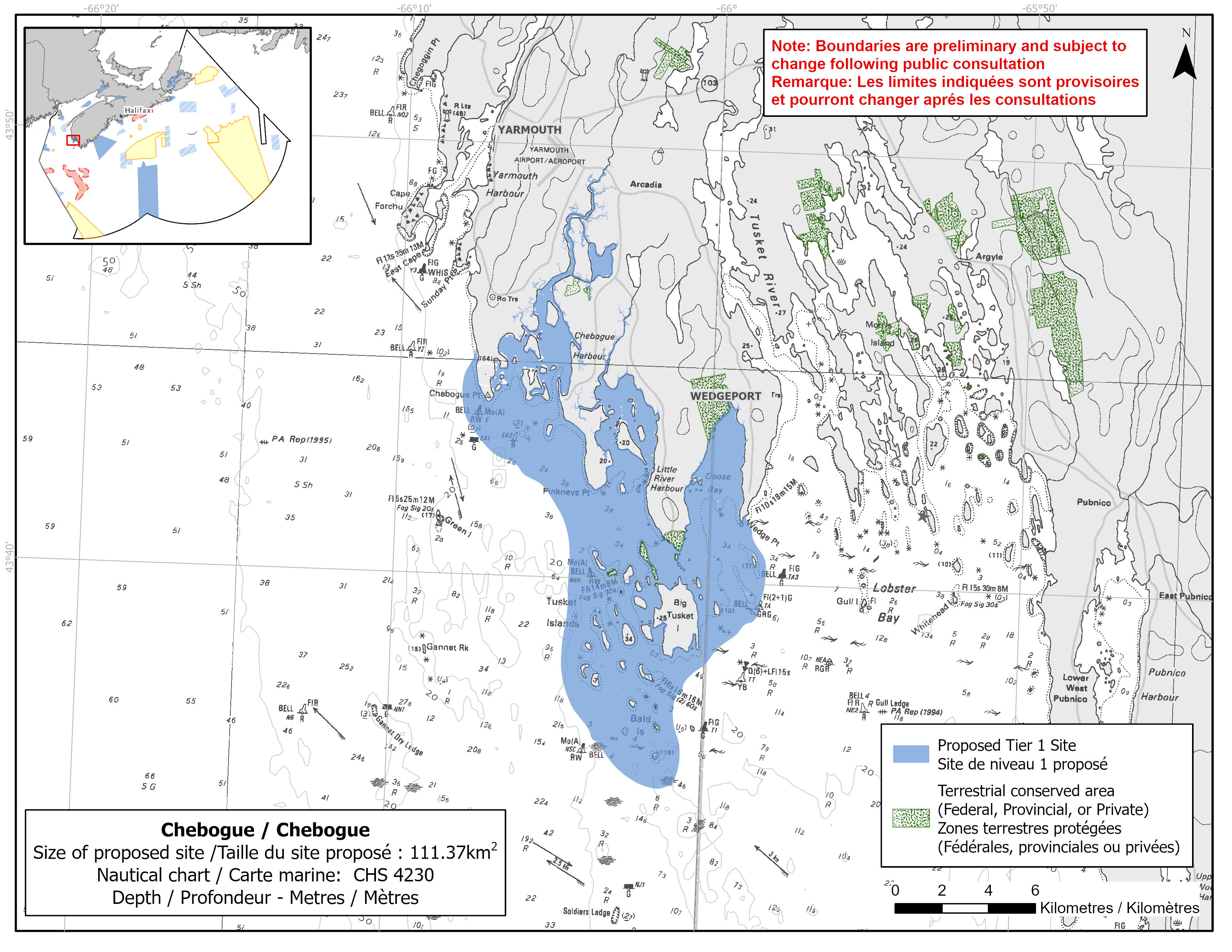
Map of proposed Chebogue network site
Simplified site coordinates
Boundaries are preliminary and subject to change following the public engagement.
| Point | Latitude | Longitude | Description |
|---|---|---|---|
| 1 | 43°41' 38.5" N | 65°58' 49.4" W | Starting at point 1 on the coastline near Wedge point |
| 2 | 43°40' 33.7" N | 65°58' 8.4" W | Connect to point 2, southeast of point 1 |
| 3 | 43°39' 15.4" N | 65°58' 22.3" W | Connect to point 3, south of point 2 |
| 4 | 43°37' 11.6" N | 66°0' 53.5" W | Connect to point 4, southwest of point 3 |
| 5 | 43°36' 13.8" N | 66°0' 40.4" W | Connect to point 5, south of point 4 |
| 6 | 43°35' 19.8" N | 66°0' 54.9" W | Connect to point 6, south of point 5 |
| 7 | 43°35' 38.9" N | 66°2' 37.2" W | Connect to point 7, west of point 6 |
| 8 | 43°37' 46.9" N | 66°4' 29.7" W | Connect to point 8, northwest of point 7 |
| 9 | 43°41' 2.5" N | 66°4' 28.4" W | Connect to point 9, northwest of point 8 |
| 10 | 43°42' 8.8" N | 66°5' 21.3" W | Connect to point 10, northwest of point 9 |
| 11 | 43°42' 47.0" N | 66°6' 49.0" W | Connect to point 11, northwest of point 10 |
| 12 | 43°44' 0.1" N | 66°7' 58.4" W | Connect to point 12, northwest of point 11 |
| 13 | 43°45' 17.0" N | 66°7' 36.8" W | Connect to point 13, north of point 12 and follow the mainland coastline east to connect point 13 to point 1. |
Size
111 km2
Features
- Important foraging area for seabirds, sea ducks and shorebirds
- Migration stopover for shorebirds
- Significant concentrations of salt marsh and marine plants
- Spawning area for Atlantic herring
- Juvenile/nursery area for windowpane flounder, cunner, three-spined stickleback, winter flounder and lobster
- Nearby terrestrial protection, including:
- Tusket Islands Wilderness Area
- Melbourne Lake Game Sanctuary
Species
This area supports species, including:
- Atlantic herring
- Windowpane flounder
- Cunner
- Three-spined stickleback
- Winter flounder
- Seabirds, sea ducks and shorebirds, such as:
- Piping plover (listed as endangered under SARA)
- Atlantic brant
- Dabbling ducks
- American lobster
- Salt marsh, eelgrass and rockweed
Use
- Current fisheries include crabs, groundfish (fixed gear), lobster and mackerel.
- Blood worm, shellfish and seaweed harvesting also occur in the area.
- Licences issued to First Nations and Indigenous communities provide access to this area to fish for food, social and ceremonial purposes.
- There is a softshell clam aquaculture lease in the Chebogue River.
- Recreational activities include:
- sea kayaking
- waterfowl hunting
- Date modified: