
Chignecto Bay
Chignecto Bay is proposed as a Tier 1 site for the Marine Conservation Network in the Scotian Shelf-Bay of Fundy Bioregion.
The lead agency for this site is Canadian Wildlife Service (Environment and Climate Change Canada).
In 2020, the Canadian Wildlife Service created an inner Bay of Fundy conservation planning team. The planning team is working to identify tools and approaches for conservation. Their work emphasizes best practice, transparency, accessibility, and participatory engagement. In 2023, the planning team identified protecting portions of the inner Bay of Fundy as a priority. For more information on this process, please contact enviroinfo@ec.gc.ca.
On this page
Location
Chignecto Bay is the northeastern arm of the inner Bay of Fundy, located between New Brunswick and Nova Scotia.
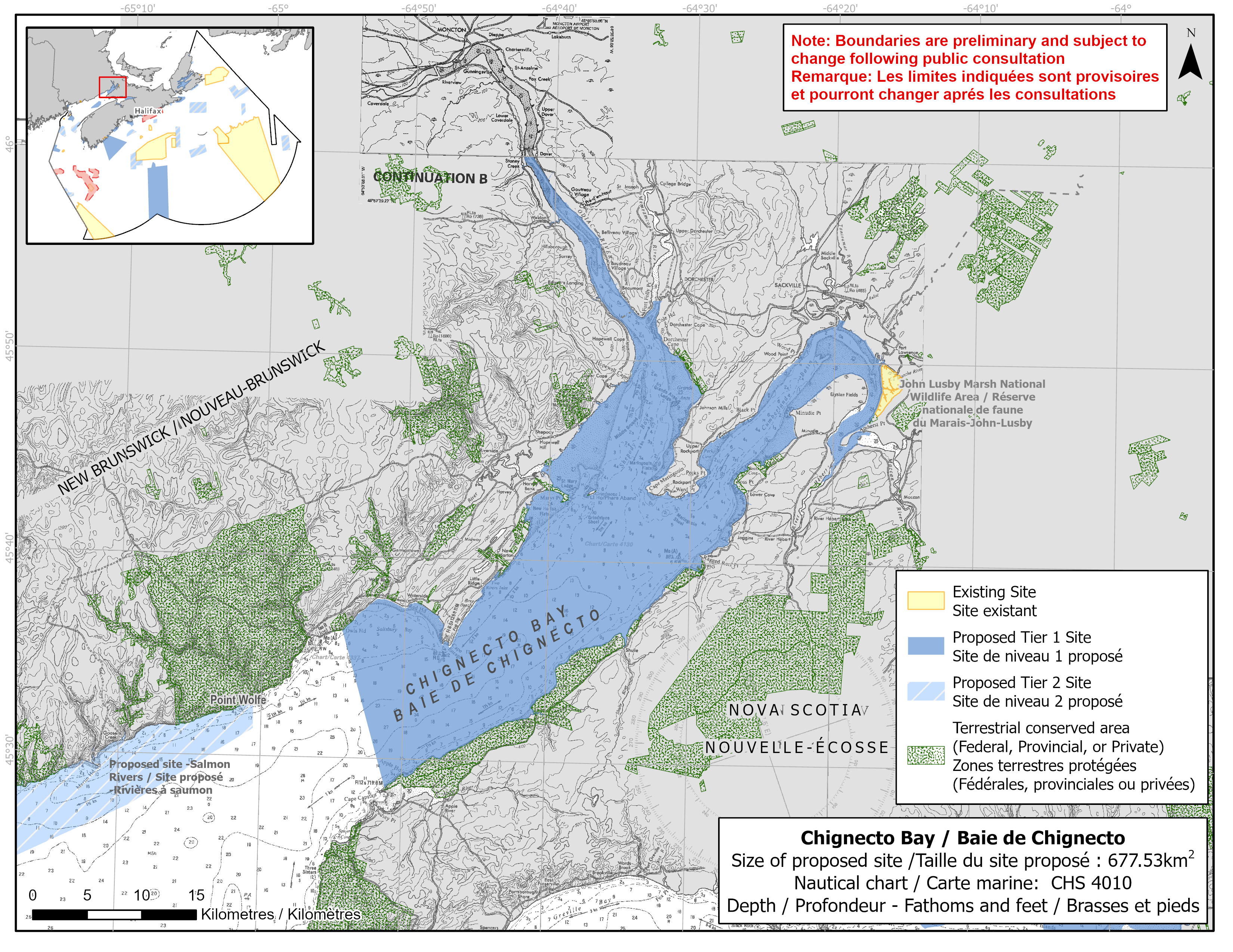
Map of proposed Chignecto Bay network site
Simplified site coordinates
Boundaries are preliminary and subject to change following the public engagement.
| Point | Latitude | Longitude | Description |
|---|---|---|---|
| 1 | 45°36' 21.344" N | 64°54' 24.233" W | Starting at point 1 on the coastline |
| 2 | 45°44' 25.337" N | 64°40' 40.393" W | Follow along the coastline northeast of point 1 to Shepody River (point 2) |
| 3 | 45°44' 55.860" N | 64°40' 12.493" W | Connect to point 3, northeast of point 2 |
| 4 | 46°0' 0.000" N | 64°42' 16.862" W | Follow along the coastline east of point 3 to Petacodiac River (point 4) |
| 5 | 45°59' 59.986" N | 64°41' 38.087" W | Connect to point 5, east of point 4 |
| 6 | 45°52' 59.551" N | 64°32' 56.870" W | Follow along the coastline southeast of point 5 to Memramcook River (point 6) |
| 7 | 45°53' 0.046" N | 64°32' 17.470" W | Connect to point 7, east of point 6 |
| 8 | 45°52' 13.814" N | 64°19' 45.947" W | Follow along the coastline south of point 7 to Tantramar River (point 8) |
| 9 | 45°52' 8.109" N | 64°19' 15.453" W | Connect to point 9, east of point 8 |
| 10 | 45°46' 39.203" N | 64°17' 19.226" W | Follow along the coastline south of point 9 to Maccan River (point 10) |
| 11 | 45°46' 28.316" N | 64°17' 27.389" W | Connect to point 11, southwest of point 10 |
| 12 | 45°44' 11.821" N | 64°20' 33.044" W | Follow along the coastline west of point 11 to River Herbert (point 12) |
| 13 | 45°44' 11.061" N | 64°20' 43.868" W | Connect to point 13, west of point 12 |
| 14 | 45°28' 32.050" N | 64°51' 9.462" W | Follow along the coastline northeast of point 13 to point 14, and connect point 14 to point 1 |
Size
678 km2
Features
- Important foraging area for seabirds, sea ducks and shorebirds
- Migratory stopover for shorebirds
- Significant concentrations of salt marsh
- Spawning area for lobster
- Identified as:
- three Important Bird Areas
- Western Hemisphere Shorebird Reserve Network site
- Ramsar Wetland of International Importance
- UNESCO Fundy Biosphere Reserve
- Nearby protection, including:
- Shepody National Wildlife Area
- Johnson's Mills Protected Natural Area
- Hopewell Rocks Provincial Park
- Grindstone Island Nature Preserve
- Fossil Cove Nature Reserve
- John Lusby Marsh National Wildlife Area
- Raven Head Wilderness Area
- Critical habitat (freshwater) for Atlantic salmon
- High productivity mudflats
Species
This area supports species including:
- Inner Bay of Fundy Atlantic salmon (listed as endangered under SARA)
- Seabirds, sea ducks and shorebirds, such as:
- Red knot (listed as endangered under SARA)
- Semipalmated sandpiper
- Dabbling ducks
- Herons
- American lobster
- Salt marsh
Use
- Current fisheries include crab, groundfish (fixed gear), lobster and scallop.
- Shellfish and bloodworm harvesting also occurs.
- Licences issued to First Nations and Indigenous communities provide access to this area to fish for food, social and ceremonial purposes.
- Recreational activities include:
- bird watching
- hiking
- beach going
- Extensive agriculture, including dyking, takes place on adjacent lands.
- Date modified: