
Cobequid Bay
Cobequid Bay is proposed as a Tier 1 site for the Marine Conservation Network in the Scotian Shelf-Bay of Fundy Bioregion.
The lead agency for this site is Canadian Wildlife Service (Environment and Climate Change Canada).
In 2020, the Canadian Wildlife Service created an inner Bay of Fundy conservation planning team. The planning team is working to identify tools and approaches for conservation. Their work emphasizes best practice, transparency, accessibility, and participatory engagement. In 2023, the planning team identified protecting portions of the inner Bay of Fundy as a priority. For more information on this process, please contact enviroinfo@ec.gc.ca.
On this page
Location
Cobequid Bay is the innermost portion of the Minas Basin in the Bay of Fundy.
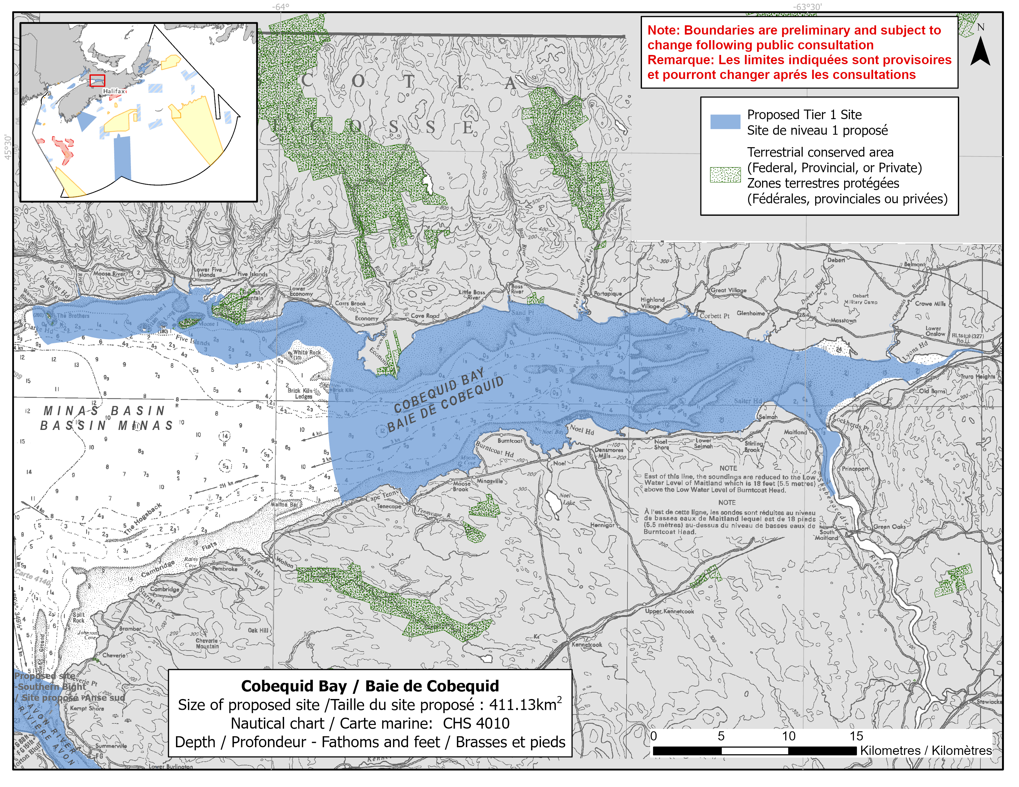
Map of proposed Cobequid Bay network site
Simplified site coordinates
Boundaries are preliminary and subject to change following the public engagement.
| Point | Latitude | Longitude | Description |
|---|---|---|---|
| 1 | 45°23' 37.5" N | 64°13' 52.7" W | Starting at point 1 on the coastline near Wasson Bluff |
| 2 | 45°22' 11.5" N | 63°19' 54.5" W | Follow along the coastline east of point 1 to Salmon River (point 2) |
| 3 | 45°22' 6.9" N | 63°19' 53.9" W | Connect to point 3, south of point 2 |
| 4 | 45°16' 29.2" N | 63°28' 14.8" W | Follow along the coastline west of point 3 to Shubenacadie River (point 4) |
| 5 | 45°16' 20.8" N | 63°28' 31.9" W | Connect to point 5, southwest of point 4 |
| 6 | 45°15' 52.3" N | 63°56' 8.5" W | Follow along the coastline north of point 5 to connect to point 6 |
| 7 | 45°18' 26.4" N | 63°56' 58.0" W | Connect to point 7, northwest of point 6 |
| 8 | 45°21' 39.3" N | 63°56' 45.6" W | Connect to point 8, north of point 7 |
| 9 | 45°22' 11.8" N | 63°57' 31.0" W | Connect to point 9, northwest of point 8 |
| 10 | 45°22' 27.0" N | 63°58' 51.7" W | Connect to point 10, northwest of point 9 |
| 11 | 45°21' 39.0" N | 64°0' 19.0" W | Connect to point 11, southwest of point 10 |
| 12 | 45°21' 25.9" N | 64°2' 38.3" W | Connect to point 12, west of point 11 |
| 13 | 45°21' 49.1" N | 64°4' 13.4" W | Connect to point 13, northwest of point 12 |
| 14 | 45°22' 24.2" N | 64°4' 40.8" W | Connect to point 14, northwest of point 13 |
| 15 | 45°22' 49.5" N | 64°6' 17.7" W | Connect to point 15, northwest of point 14 |
| 16 | 45°22' 23.6" N | 64°8' 55.7" W | Connect to point 16, southwest of point 15 |
| 17 | 45°22' 30.4" N | 64°10' 51.8" W | Connect to point 17, west of point 16 |
| 18 | 45°22' 6.2" N | 64°12' 58.7" W | Connect to point 18, southwest of point 17 |
| 19 | 45°22' 49.6" N | 64°13' 42.6" W | Connect to point 19, northwest of point 18 and connect point 19 to point 1 |
Size
411 km2
Features
- Important foraging area for migrating shorebirds, waterfowl and other marine birds
- Migratory stopover for shorebirds and anadromous fishes
- Significant concentrations of remaining inner Bay of Fundy salt marsh
- Feeding and nursery area for fish species including striped bass
- Identified as an Important Bird Area and a Western Hemisphere Shorebird Reserve Network site
- Nearby protection, including:
- Economy Point Nature Reserve
- Lyons Marsh Nature Reserve
- Five Islands Provincial Park
- Brothers Islands Conservation Lands
- Thomas Cove Coastal Reserve
- Anthony Provincial Park
- Critical habitat (freshwater) for Atlantic salmon
- High productivity due to mudflats
Species
This area supports species including:
- Inner Bay of Fundy Atlantic salmon (listed as endangered under SARA)
- Atlantic mud-piddock (listed as threatened under SARA) and Mud shrimp
- Striped bass (assessed as endangered by COSEWIC)
- Atlantic sturgeon (assessed as threatened by COSEWIC)
- Atlantic herring and other forage fish species
- American eel (assessed as threatened by COSEWIC)
- Shorebirds, waterfowl and other marine birds, such as:
- Semipalmated sandpiper
- Black-bellied plovers
- Blue-winged teal
- Salt marsh
Use
- Current fisheries include crab, groundfish (fixed gear) and lobster. Other nearshore, small-scale fisheries for eel, gaspereau, herring and other species also occur.
- Shellfish harvesting also occurs.
- Licenses issued to First Nations and Indigenous communities provide access to this area to fish for food, social and ceremonial purposes.
- Recreational activities include:
- wildlife observation
- camping
- hiking
- tidal bore rafting
- Extensive agriculture, including dyking, takes place on adjacent lands.
- Date modified: