
Country Island
Country Island is proposed as a Tier 2 site for the Marine Conservation Network in the Scotian Shelf-Bay of Fundy Bioregion.
On this page
Location
Country Island spans from Drum Head to Goose Point and includes the waters around Goose Island, Harbour Island, Country Island, Coddles Island and other nearby small islands.
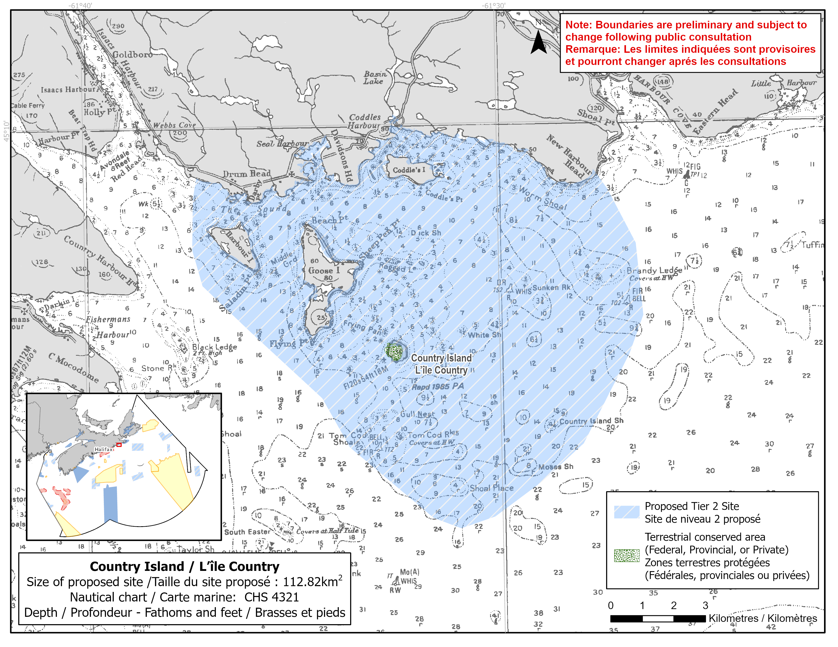
Map of proposed Country Island network site
Simplified site coordinates
Boundaries are preliminary and subject to change following the public engagement.
| Point | Latitude | Longitude | Description |
|---|---|---|---|
| 1 | 45°9' 10.857" N | 61°27' 40.492" W | Starting at point 1 on the coastline, in the northeast of the site |
| 2 | 45°7' 54.050" N | 61°26' 40.473" W | Connect to point 2, southeast of point 1 |
| 3 | 45°6' 40.056" N | 61°26' 31.449" W | Connect to point 3, south of point 2 |
| 4 | 45°4' 29.156" N | 61°28' 1.220" W | Connect to point 4, southwest of point 3 |
| 5 | 45°3' 15.591" N | 61°30' 11.456" W | Connect to point 5, southwest of point 4 |
| 6 | 45°3' 4.161" N | 61°31' 0.854" W | Connect to point 6, southwest of point 5 |
| 7 | 45°3' 15.330" N | 61°31' 40.650" W | Connect to point 7, northwest of point 6 |
| 8 | 45°5' 20.222" N | 61°34' 18.879" W | Connect to point 8, northwest of point 7 |
| 9 | 45°7' 17.389" N | 61°37' 9.524" W | Connect to point 9, northwest of point 8 |
| 10 | 45°7' 54.496" N | 61°37' 23.680" W | Connect to point 10, north of point 9 |
| 11 | 45°9' 8.279" N | 61°37' 15.951" W | Connect to point 11 on the coastline, north of point 10 and follow along the coastline to connect point 11 to point 1 |
Size
113 km2
Features
- Important foraging area for seabirds, sea ducks and shorebirds
- Significant nesting area for birds
- Presence of marine plants
- Identified as an Important Bird Area
- Nearby terrestrial protection, including:
- Country Island National Wildlife Area (proposed)
- Critical habitat for roseate terns
Species
This area supports species including:
- Seabirds, sea ducks and shorebirds, such as :
- Roseate tern (listed as endangered under SARA)
- Leach's storm-petrel
- American black duck
- Eelgrass
Use
- Current fisheries include bluefin tuna, lobster and scallop.
- Seaweed harvesting also occurs in the area.
- Licences issued to First Nations and Indigenous communities provide access to this area to fish for food, social and ceremonial purposes.
- Date modified: