
Fleur-de-Lis Coast
Fleur-de-Lis Coast is proposed as a Tier 2 site for the Marine Conservation Network in the Scotian Shelf-Bay of Fundy Bioregion.
On this page
Location
Fleur-de-Lis Coast is located off the southern coast of Cape Breton from Strachans Cove to Gabarus.
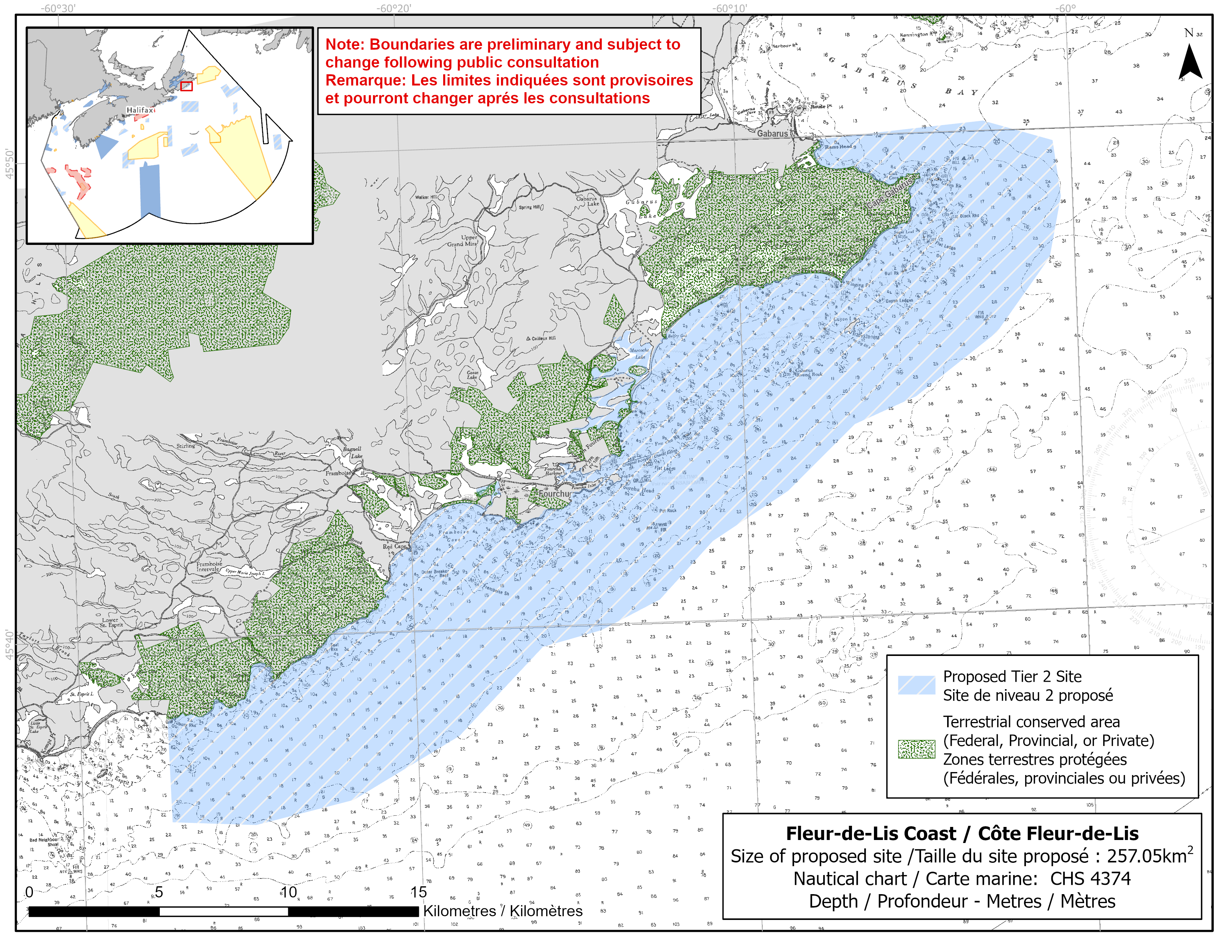
Map of proposed Fleur-de-Lis Coast network site
Simplified site coordinates
Boundaries are preliminary and subject to change following the public engagement.
| Point | Latitude | Longitude | Description |
|---|---|---|---|
| 1 | 45°49' 56.737" N | 60°7' 32.347" W | Starting at point 1 on the coastline, in the northeast of the site |
| 2 | 45°50' 12.900" N | 60°2' 35.025" W | Connect to point 2, east of point 1 |
| 3 | 45°49' 45.348" N | 60°0' 32.087" W | Connect to point 3, southeast of point 2 |
| 4 | 45°48' 35.483" N | 60°0' 20.908" W | Connect to point 4, south of point 3 |
| 5 | 45°47' 19.581" N | 60°0' 44.866" W | Connect to point 5, southwest of point 4 |
| 6 | 45°45' 48.246" N | 60°2' 24.178" W | Connect to point 6, southwest of point 5 |
| 7 | 45°36' 32.603" N | 60°21' 58.392" W | Connect to point 7, southwest of point 6 |
| 8 | 45°36' 5.289" N | 60°24' 53.120" W | Connect to point 8, southwest of point 7 |
| 9 | 45°36' 12.101" N | 60°27' 21.483" W | Connect to point 9, west of point 8 |
| 10 | 45°38' 21.383" N | 60°27' 24.825" W | Connect to point 10 on the coastline, north of point 9 and follow along the coastline to connect point 10 to point 1 |
Size
257 km2
Features
- Important foraging area for seabirds and shorebirds
- Significant nesting site for great cormorants
- Important concentrations of salt marsh and marine plants
- Identified as an Important Bird Area
- Nearby terrestrial protection, including:
- Gabarus Wilderness Area
- Fourchu Coast Wilderness Area
- High naturalness on adjacent coast
Species
This area supports species, including:
- Seabirds and shorebirds, such as:
- Great cormorant
- Common eider
- Great black-backed gull
- Black-legged kittiwake
- Salt marsh and kelp
Use
- Current fisheries include bluefin tuna, crab, groundfish, lobster, mackerel, scallop, shrimp (mobile gear) and sea urchin (dive).
- There is a moratorium on fishing cod and haddock on the Eastern Scotian Shelf.
- Licences issued to First Nations and Indigenous communities provide access to this area to fish for food, social and ceremonial purposes.
- Recreational activities include:
- beachgoing
- hiking
- Date modified: