
Georges Bank
Georges Bank is proposed as a Tier 2 site for the Marine Conservation Network in the Scotian Shelf-Bay of Fundy Bioregion.
On this page
Location
Georges Bank is located near the middle of the Canadian portion of the larger bank feature along the United States border, approximately 230 km southwest of Yarmouth, Nova Scotia.
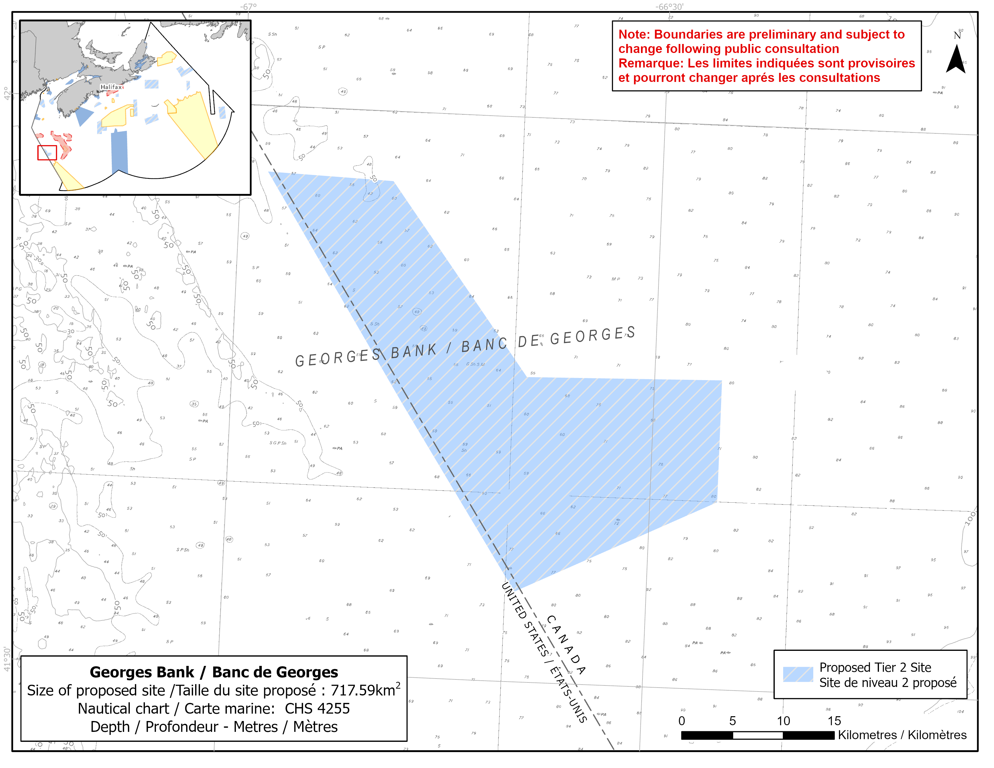
Map of proposed Georges Bank network site
Simplified site coordinates
Boundaries are preliminary and subject to change following the public engagement.
| Point | Latitude | Longitude | Description |
|---|---|---|---|
| 1 | 41°56' 30.5" N | 66°58' 4.9" W | Starting at point 1 in the northwest corner of the site on the Canada/US boundary |
| 2 | 41°56' 18.0" N | 66°49' 7.8" W | Connect to point 2, northeast of point 1 |
| 3 | 41°46' 12.7" N | 66°39' 3.6" W | Connect to point 3, southeast of point 2 |
| 4 | 41°46' 27.7" N | 66°25' 13.1" W | Connect to point 4 in the northeast corner of the site |
| 5 | 41°39' 58.9" N | 66°25' 13.2" W | Connect to point 5 in the southeast corner of the site |
| 6 | 41°34' 47.8" N | 66°39' 18.5" W | Connect to point 6 in the southwest corner of site on the Canada/US boundary, follow Canada/US boundary NW to point 1 |
Size
718 km2
Features
- Important habitat for groundfish
- Area of high fish and larval fish diversity
- Area of high primary productivity
- Site occurs within a seasonal haddock fisheries closure
- Representative example of Georges Bank habitats
Species
This area supports species, including:
- Depleted groundfish populations, such as:
- American plaice (assessed as threatened by COSEWIC)
- Atlantic cod (assessed as endangered by COSEWIC)
Use
- This general area contains some of the most important fishing grounds in Atlantic Canada.
- Fisheries in this site are comparatively low.
- Current fisheries include groundfish (mostly mobile gear), scallop, swordfish, and tuna.
- Licences issued to First Nations and Indigenous communities provide access to this area to fish for food, social and ceremonial purposes.
- Moderate shipping traffic.
- Date modified: