
Inner Shelf Sea Pen Field
Inner Shelf Sea Pen Field is proposed as a Tier 2 site for the Marine Conservation Network in the Scotian Shelf-Bay of Fundy Bioregion.
On this page
Location
Inner Shelf Sea Pen Field is located northeast of Emerald Basin on the Scotian Shelf, approximately 90 km east of Halifax, Nova Scotia.
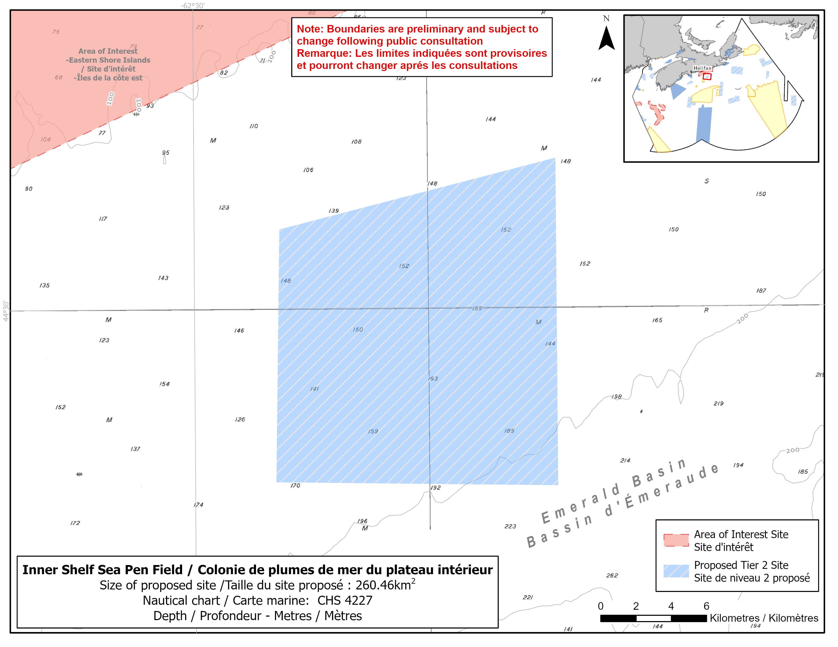
Map of proposed Inner Shelf Sea Pen Field network site
Simplified site coordinates
Boundaries are preliminary and subject to change following the public engagement.
| Point | Latitude | Longitude | Description |
|---|---|---|---|
| 1 | 44°34' 34.9" N | 62°14' 30.4" W | Starting at point 1 on the north side of the site |
| 2 | 44°24' 32.7" N | 62°14' 30.8" W | Connect to point 2, south of point 1 |
| 3 | 44°24' 42.2" N | 62°26' 32.9" W | Connect to point 3, west of point 2 |
| 4 | 44°32' 27.0" N | 62°26' 21.1" W | Connect to point 4, north of point 3 and connect point 4 to point 1 |
Size
260 km2
Features
- Significant concentrations of sea pens
- Important habitat for white hake
- Area of high fish and invertebrate diversity
- Marine refuge in Emerald Basin about 15 km to the southwest
- Representative example of shelf flat habitat
Species
This area supports species including:
- Depleted groundfish populations, such as:
- White hake (assessed as threatened by COSEWIC)
- Sea pens
Use
- Current fisheries include groundfish (fixed and mobile gear), hagfish, herring (fixed and mobile gear), scallop, swordfish and tuna.
- Lobster fishing may also occur.
- There is currently a moratorium on fishing Atlantic cod and haddock on the Eastern Scotian Shelf.
- Licences issued to First Nations and Indigenous communities provide access to this area to fish for food, social and ceremonial purposes.
- High shipping traffic due to its proximity to Halifax Harbour.
- Date modified: