
LaHave Islands
LaHave Islands
LaHave Islands is proposed as a Tier 1 site for the Marine Conservation Network in the Scotian Shelf-Bay of Fundy Bioregion.
The lead agency for this site is Fisheries and Oceans Canada.
On this page
Location
LaHave Islands includes the waters around a cluster of coastal islands at the mouth of the Petite Rivière and LaHave River. It extends along the Atlantic coast of Nova Scotia from Port Medway in the west to the Kingsburg Peninsula in the east.
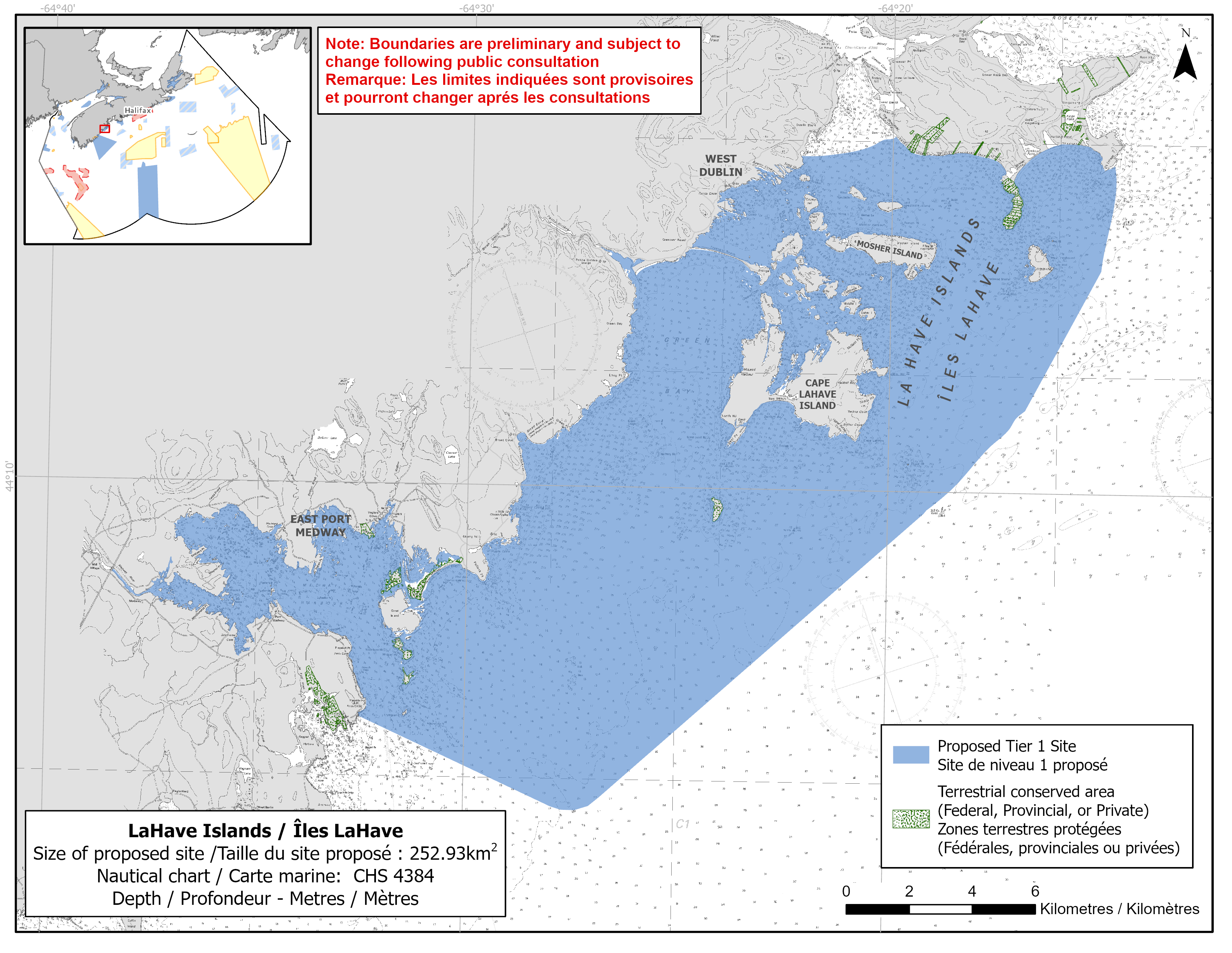
Map of proposed LaHave Islands network site
Simplified site coordinates
Boundaries are preliminary and subject to change following the public engagement.
| Point | Latitude | Longitude | Description |
|---|---|---|---|
| 1 | 44°15' 38.5" N | 64°14' 42.2" W | Starting at point 1 on the coastline near Point Enrage |
| 2 | 44°13' 49.8" N | 64°14' 59.5" W | Connect to point 2, south of point 1 |
| 3 | 44°11' 7.1" N | 64°17' 7.1" W | Connect to point 3, southwest of point 2 |
| 4 | 44°4' 27.7" N | 64°27' 20.3" W | Connect to point 4, southwest of point 3 |
| 5 | 44°6' 0.5" N | 64°32' 30.2" W | Connect to point 5 on the mainland coastline near Medway Head, northwest of point 4 |
| 6 | 44°8' 24.7" N | 64°38' 26.7" W | Follow along mainland coastline northeast to Medway River point 6 |
| 7 | 44°8' 27.0" N | 64°38' 24.7" W | Connect to point 7, northeast of point 6 |
| 8 | 44°14' 6.6" N | 64°26' 56.0" W | Follow along mainland coastline southeast to Petite Rivère point 8 |
| 9 | 44°14' 7.0" N | 64°26' 55.3" W | Connect to point 9, northeast of point 8 |
| 10 | 44°15' 44.0" N | 64°22' 11.0" W | Follow along mainland coastline southeast to Dublin Shore point 10 |
| 11 | 44°15' 45.9" N | 64°21' 25.8" W | Connect to point 11, east of point 10 |
| 12 | 44°15' 59.1" N | 64°20' 21.4" W | Connect to point 12, northeast of point 11 |
| 13 | 44°16' 5.7" N | 64°19' 55.9" W | Connect to point 13 on the coastline, northeast of point 12 and follow the mainland coastline east to connect point 13 to point 1 |
Size
253 km2
Features
- Important foraging area for seabirds, sea ducks and shorebirds
- Important nesting area for shorebirds
- Significant concentrations of salt marsh and marine plants
- Nearby Petite Rivière watershed supports the only remaining population of Atlantic whitefish
- The recovery strategy for this species calls for restoring a route to the ocean
- Identified as an Important Bird Area
- Nearby terrestrial protections, including:
- Hirtle’s Beach Municipal Park
- Risser’s Beach Provincial Park
- Cherry Hill Beach Nature Reserve
- Ragged Harbour Nature Reserve
- Gaff Point and other sites on the Kingsburg Peninsula are protected by Kingsburg Coastal Conservancy
- Indian Island, Long Cove, Middle Island, Great Island, Selig Island, Cormorant Island and Voglers Cove are protected by the Nova Scotia Nature Trust
- Critical habitat for piping plover
Species
This area supports species, including:
- Nova Scotia Southern Upland Atlantic salmon (assessed as endangered by COSEWIC)
- Atlantic whitefish (listed as endangered under SARA)
- Seabirds, sea ducks and shorebirds, such as:
- Piping plover (listed as endangered under SARA)
- Red knot (listed as endangered under SARA)
- Roseate tern (listed as endangered under SARA)
- Barrow’s goldeneye (listed as special concern under SARA)
- Eelgrass, salt marsh and kelp
Use
- Current fisheries include bluefin tuna, groundfish (fixed gear), herring (fixed gear), lobster, mackerel and scallop.
- Shellfish, Irish moss and rockweed harvesting also occur in the area.
- Licences issued to First Nations and Indigenous communities provide access to this area to fish for food, social and ceremonial purposes.
- Recreational activities include:
- beach going
- kayaking
- camping
- boating
- recreational clamming (may occur)
- Date modified: