
Long Eddy
Long Eddy is proposed as a Tier 1 site for the Marine Conservation Network in the Scotian Shelf-Bay of Fundy Bioregion.
The lead agency for this site is Fisheries and Oceans Canada.
On this page
Location
Long Eddy is located off the northern tip of Grand Manan Island in the Bay of Fundy.
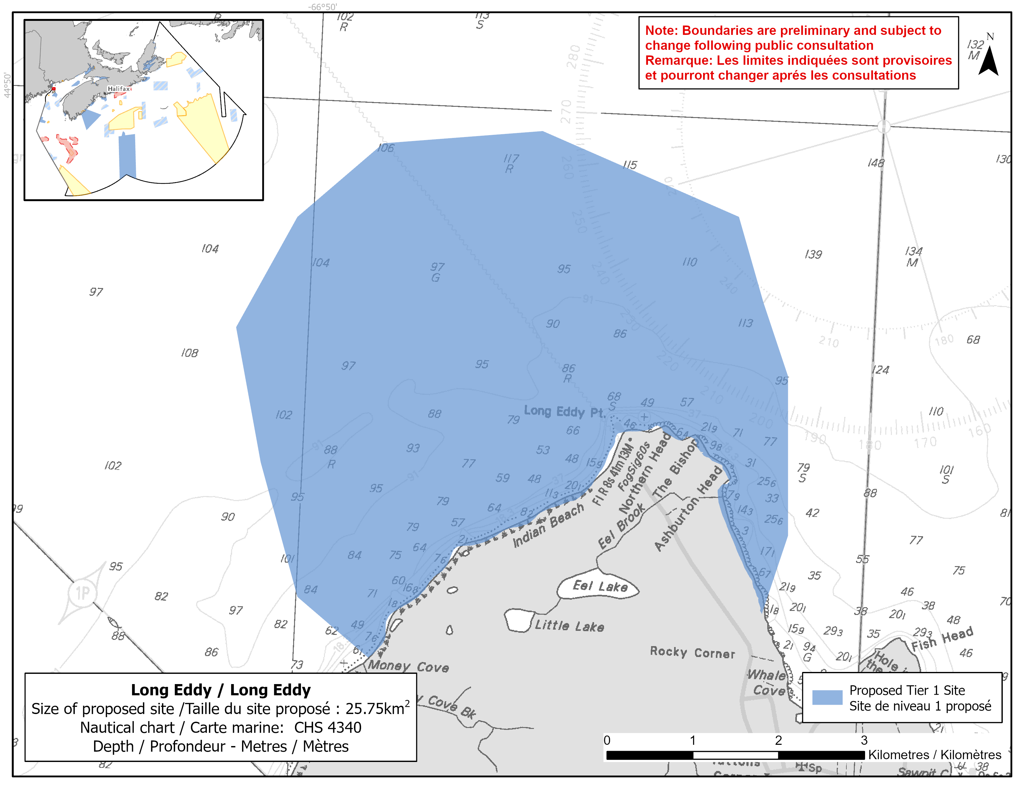
Map of proposed Long Eddy network site
Simplified site coordinates
Boundaries are preliminary and subject to change following the public engagement.
| Point | Latitude | Longitude | Description |
|---|---|---|---|
| 1 | 44°46' 30.4" N | 66°49' 19.8" W | Starting at point 1 on the coastline of Grand Manan |
| 2 | 44°46' 52.1" N | 66°49' 58.7" W | Connect to point 2, northwest of point 1 |
| 3 | 44°48' 32.7" N | 66°50' 38.0" W | Connect to point 3, northwest of point 2 |
| 4 | 44°49' 15.4" N | 66°50' 8.2" W | Connect to point 4, northeast of point 3 |
| 5 | 44°49' 44.7" N | 66°49' 24.6" W | Connect to point 5, northeast of point 4 |
| 6 | 44°49' 52.1" N | 66°48' 0.4" W | Connect to point 6, east of point 5 |
| 7 | 44°49' 23.2" N | 66°46' 14.3" W | Connect to point 7, southeast of point 6 |
| 8 | 44°48' 23.9" N | 66°45' 44.4" W | Connect to point 8, southeast of point 7 |
| 9 | 44°47' 23.8" N | 66°45' 40.5" W | Connect to point 9, south of point 8 |
| 10 | 44°46' 53.6" N | 66°45' 52.5" W | Connect to point 10 on the coastline of Grand Manan, southwest of point 9 and follow the Grand Manan coastline west to connect point 10 to point 1 |
Size
26 km2
Features
- Feeding area for whales and porpoises
- Important foraging area for seabirds and shorebirds
- Spawning area for Atlantic herring
- High fish and invertebrate diversity
- Nearby terrestrial protections, including:
- Seven Days Work Cliff Nature Preserve
- Thomas B. Munro Nature Preserve
- High productivity due to an area of persistent upwelling
Species
This area supports species, including:
- Cetaceans, such as:
- North Atlantic right whale (listed as endangered under SARA)
- Fin whale (listed as special concern under SARA)
- Harbour porpoise (assessed as special concern by COSEWIC)
- Minke whale
- Atlantic herring
- Seabirds and shorebirds, such as:
- Large auks
- Northern gannet
- Dovekies
- Phalaropes
- Storm-petrels
Use
- Current fisheries include groundfish, lobster and scallop.
- Seaweed harvesting also occurs in the area.
- Licences issued to First Nations and Indigenous communities provide access to this area to fish for food, social and ceremonial purposes.
- Recreational activities include:
- kayaking
- seaside camping
- bird and whale watching
- A ferry route between Blacks Harbour, New Brunswick and North Head on Grand Manan passes to the east of Long Eddy.
- An underwater power cable passes through the site.
- Date modified: