
Martinique Beach and Musquodoboit Harbour
Martinique Beach and Musquodoboit Harbour is proposed as a Tier 2 site for the Marine Conservation Network in the Scotian Shelf-Bay of Fundy Bioregion.
On this page
Location
Martinique Beach and Musquodoboit Harbour is located along the coast of eastern Nova Scotia. It includes the waters of Musquodoboit Harbour to approximately 3 km south of Martinique Beach. The site includes the waters around Francis Nose Island, Gunner Island, Kent Island and other nearby islands.
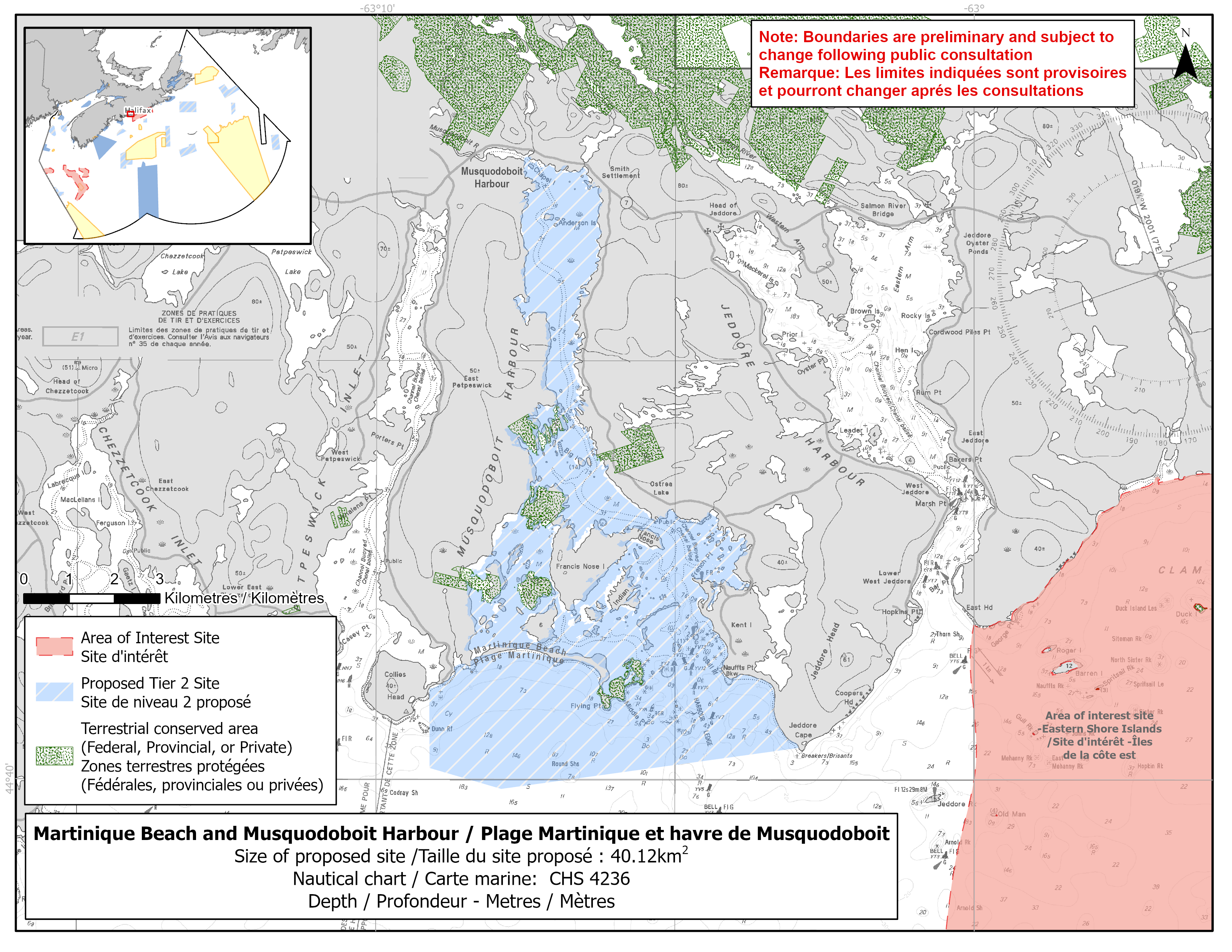
Map of proposed Martinique Beach and Musquodoboit Harbour network site
Simplified site coordinates
Boundaries are preliminary and subject to change following the public engagement.
| Point | Latitude | Longitude | Description |
|---|---|---|---|
| 1 | 44°40' 23.031" N | 63°2' 55.663" W | Starting at point 1 on the coastline, in the southeast of the site |
| 2 | 44°39' 53.416" N | 63°7' 54.364" W | Connect to point 2, west of point 1 |
| 3 | 44°40' 8.290" N | 63°9' 6.289" W | Connect to point 3, north of point 2 |
| 4 | 44°41' 4.979" N | 63°9' 6.722" W | Connect to point 4 on the coastline, northwest of point 3 |
| 5 | 44°47' 20.494" N | 63°7' 32.819" W | Follow along the coastline east of point 4 to Musquodoboit River (point 5) |
| 6 | 44°47' 24.738" N | 63°7' 32.239" W | Connect to point 6, north of point 5 and follow along the coastline to connect point 6 to point 1 |
Size
40 km2
Features
- Important foraging area for seabirds, sea ducks and shorebirds
- Significant concentrations of salt marsh and marine plants
- Spawning river for Atlantic salmon drains into Musquodoboit Harbour
- Identified as an Important Bird Area and Ramsar Wetland of International Importance
- Nearby terrestrial protection, including:
- Nature Conservancy Canada's Musquodoboit Harbour Conservation Lands, which encompass parts of Mikes Islands, Gunner Island, Bayers Island and Young Island
- Critical habitat for piping plover
- Area of high productivity due to its geophysical characteristics
Species
This area supports species including:
- Nova Scotia Southern Upland Atlantic salmon (assessed as endangered by COSEWIC)
- Atlantic herring
- Seabirds, sea ducks and shorebirds, such as:
- Piping plover (listed as endangered under SARA)
- Harlequin duck (listed as special concern under SARA)
- Barrow's goldeneye (listed as special concern under SARA)
- American black duck
- Salt marsh and eelgrass
Use
- Current fisheries include herring (fixed gear), lobster and mackerel.
- Shellfish and seaweed harvesting also occur in the area.
- Licences issued to First Nations and Indigenous communities provide access to this area to fish for food social and ceremonial purposes.
- Recreational activities include:
- beachgoing
- hiking
- recreational fishing
- Date modified: