
Misaine Bank and Laurentian Channel
Misaine Bank and Laurentian Channel is proposed as a Tier 2 site for the Marine Conservation Network in the Scotian Shelf-Bay of Fundy Bioregion.
On this page
Location
Misaine Bank and Laurentian Channel is located along the eastern edge of Misaine Bank, where the shelf meets the channel. This area extends approximately midway into the Laurentian Channel.
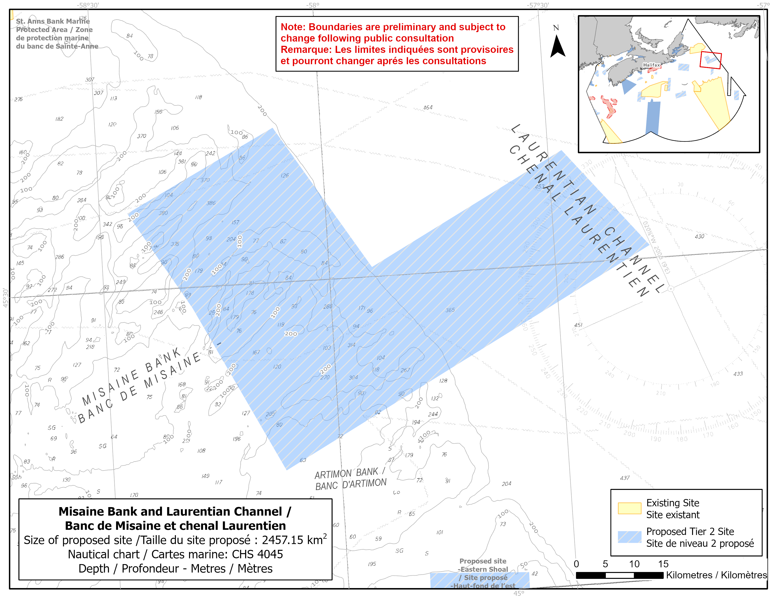
Map of the proposed Misaine Bank and Laurentian Channel network site
Simplified site coordinates
Boundaries are preliminary and subject to change following the public engagement.
| Point | Latitude | Longitude | Description |
|---|---|---|---|
| 1 | 45°44' 26.8" N | 58°6' 20.3" W | Starting at point 1 in the north of the site |
| 2 | 45°30' 53.7" N | 57°54' 18.6" W | Connect to point 2, southeast of point 1 |
| 3 | 45°40' 36.5" N | 57°28' 10.8" W | Connect to point 3, northeast of point 2 |
| 4 | 45°31' 12.6" N | 57°17' 23.0" W | Connect to point 4, southeast of point 3 |
| 5 | 45°12' 26.1" N | 58°7' 14.1" W | Connect to point 5, southwest of point 4 |
| 6 | 45°28' 3.5" N | 58°18' 22.1" W | Connect to point 6, northwest of point 5 |
| 7 | 45°37' 14.3" N | 58°26' 18.9" W | Connect to point 7, northwest of point 3 and the connect point 7 to point 1 |
Size
2 457 km2
Features
- High abundance of sea pens
- Foraging habitat for seabirds
- Important migratory route for fish, whales and sea turtles
- Important habitat for groundfish
- Area of high fish and invertebrate diversity
- Nearby protection, including:
- St. Anns Bank Marine Protected Area located about 35 km to the northwest
- Laurentian Channel Marine Protected Area located about 10 km to the north
- Representative example of bank, basin and channel habitats
- Complex seafloor topography
Species
This area supports species, including:
- Cetaceans, such as:
- Fin whale (listed as special concern under SARA)
- Humpback whale
- Minke whale
- Long-finned pilot whale
- Leatherback turtles (listed as endangered under SARA)
- Sand lance
- Depleted groundfish populations, such as:
- Atlantic cod (assessed as endangered by COSEWIC)
- American plaice (assessed as threatened by COSEWIC)
- Thorny skate (assessed as special concern by COSEWIC)
- Smooth skate (assessed as special concern by COSEWIC)
- White hake (assessed as threatened by COSEWIC)
- Atlantic wolffish (listed as special concern under SARA)
Use
- Current fisheries include groundfish (fixed and mobile gear), shrimp and snow crab.
- In recent years, the site has had relatively low amounts of commercial fishing.
- There is currently a moratorium on fishing cod and haddock on the Eastern Scotian Shelf.
- Licences issued to First Nations and Indigenous communities provide access to this area to fish for food, social and ceremonial purposes.
- High shipping traffic.
- Date modified: