
Sable Island Bank
Sable Island Bank is proposed as a Tier 2 site for the Marine Conservation Network in the Scotian Shelf-Bay of Fundy Bioregion.
On this page
Location
Sable Island Bank is located approximately 75 km west of Sable Island. It includes a small portion of both Sable Island Bank and Western Bank. This site is immediately east of the Western/Emerald Banks Marine Refuge.
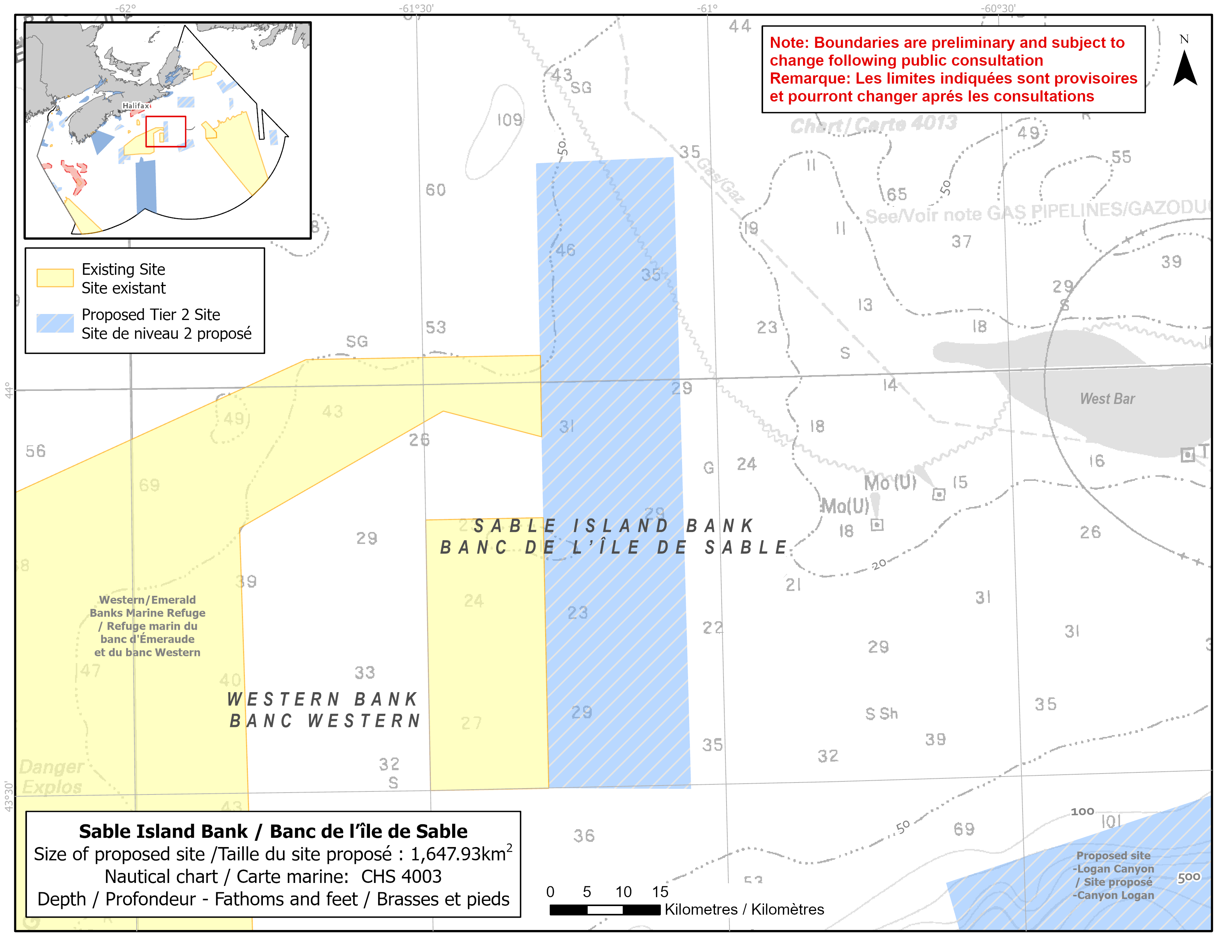
Map of proposed Sable Island Bank network site
Simplified site coordinates
Boundaries are preliminary and subject to change following the public engagement.
| Point | Latitude | Longitude | Description |
|---|---|---|---|
| 1 | 44°16' 11.5" N | 61°17' 59.5" W | Starting at point 1 on the northwest side of the site |
| 2 | 44°16' 25.8" N | 61°3' 50.2" W | Connect to point 2, east of point 1 |
| 3 | 43°29' 43.5" N | 61°3' 33.3" W | Connect to point 3, south of point 2 |
| 4 | 43°30' 0.5" N | 61°18' 0.7" W | Connect to point 4, east of point 3 and connect point 4 to point 1 |
Size
1 648 km2
Features
- Spawning and nursery area for groundfish, particularly haddock
- Important fish habitat
- Area of high invertebrate, fish and larval fish diversity
- Western/Emerald Banks Marine Refuge is located to the west
- Representative example of bank and basin habitat
- Unique oceanography (partial gyre)
Species
This area supports species, including:
- Ocean pout
- Depleted groundfish populations, such as:
- Atlantic cod (assessed as endangered by COSEWIC)
- Winter skate (assessed as endangered by COSEWIC)
- Smooth skate (assessed as special concern by COSEWIC)
Use
- Current fisheries include bluefin tuna, crab, groundfish (fixed and mobile gear), hagfish, scallop, sea cucumber and swordfish.
- There is currently a moratorium on fishing Atlantic cod and haddock on the Eastern Scotian Shelf.
- Licences issued to First Nations and Indigenous communities provide access to this area to fish for food, social and ceremonial purposes.
- Date modified: