
Salmon Rivers
Salmon Rivers is proposed as a Tier 2 site for the Marine Conservation Network in the Scotian Shelf-Bay of Fundy Bioregion.
On this page
Location
Salmon Rivers is located along the New Brunswick shoreline of the Bay of Fundy, from the outflow of the Big Salmon River to Matthews Head in Fundy National Park. The site includes outflows of the Big Salmon River and Little Salmon River.
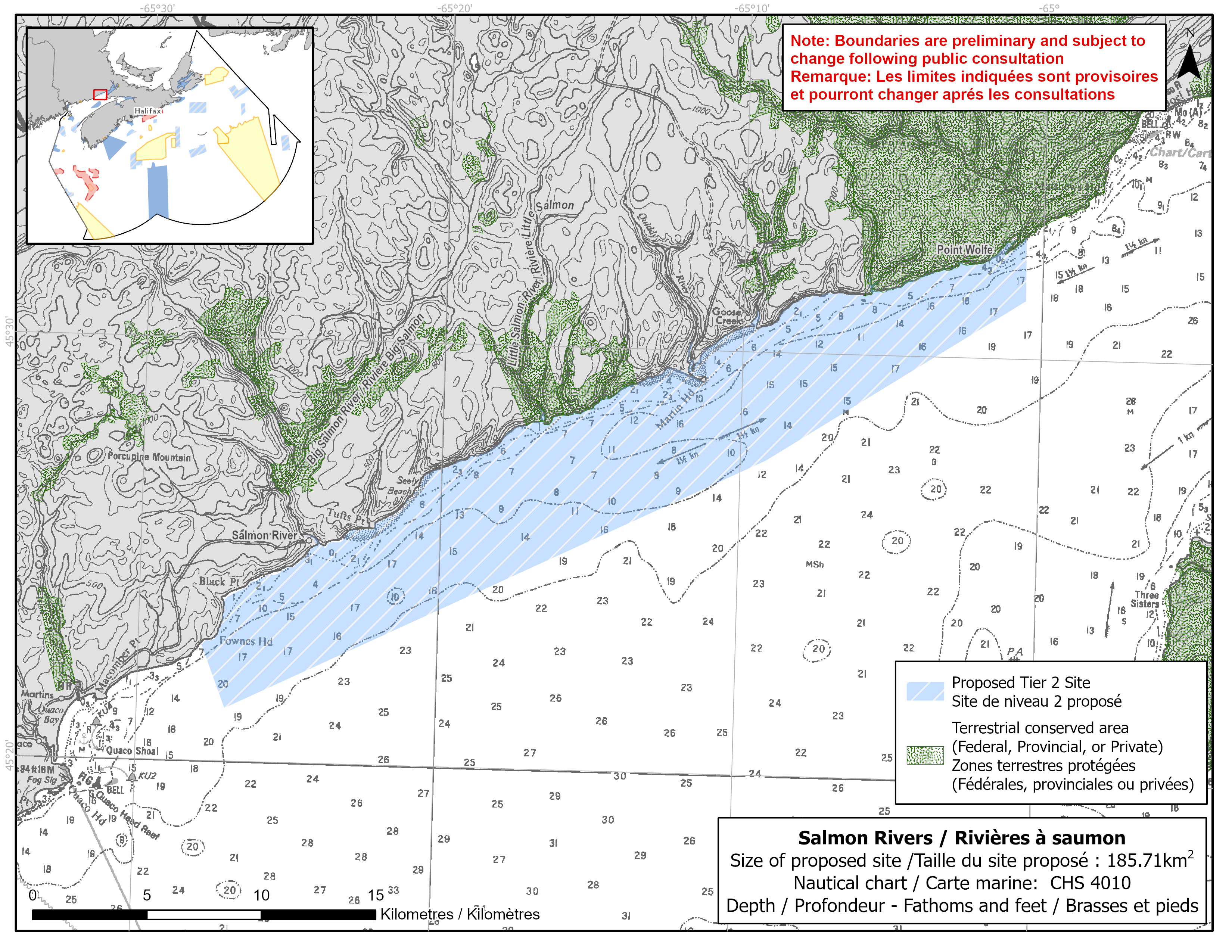
Map of proposed Salmon Rivers network site
Simplified site coordinates
Boundaries are preliminary and subject to change following the public engagement.
| Point | Latitude | Longitude | Description |
|---|---|---|---|
| 1 | 45°32' 53.636" N | 65°0' 34.153" W | Starting at point 1 on the coastline, in the northeast of the site |
| 2 | 45°31' 23.508" N | 65°0' 32.647" W | Connect to point 2, south of point 1 |
| 3 | 45°27' 28.486" N | 65°9' 8.051" W | Connect to point 3, south of point 2 |
| 4 | 45°21' 16.195" N | 65°27' 2.786" W | Connect to point 4, southwest of point 3 |
| 5 | 45°22' 44.789" N | 65°27' 52.430" W | Connect to point 5 on the coastline, northeast of point 4 and follow along the coastline to connect point 5 to point 1 |
Size
186 km2
Features
- Cultural significance for Indigenous peoples
- Important foraging area for seabirds, sea ducks and shorebirds
- Migratory stopover for shorebirds
- Important concentrations of salt marsh and marine plants
- Next to the UNESCO Fundy Biosphere Reserve
- Nearby protection, including:
- Proposed by the Mi'kmaq and Wolastoqiyik as an Indigenous Protected and Conserved Area
- Fundy National Park
- Little Salmon River Protected Area
- Big Salmon River Protected Natural Area
- Critical habitat (freshwater) for Atlantic salmon
- Extensive rocky shoreline areas and high naturalness
Species
This area supports species including:
- Inner Bay of Fundy Atlantic salmon (listed as endangered under SARA)
- Seabirds, sea ducks and shorebirds, such as:
- Semipalmated sandpiper
- Red-throated loon
- Black scoter
- Salt marsh and rockweed
Use
- Current fisheries include bluefin tuna, lobster and scallop. Other nearshore, small-scale fisheries for eel, gaspereau, herring and other species may occur.
- Shellfish harvesting also occurs.
- Licenses issued to First Nations and Indigenous communities provide access to this area to fish for food, social and ceremonial purposes.
- Recreational activities include:
- camping
- hiking
- Date modified: