
South Grand Manan
South Grand Manan is proposed as a Tier 1 site for the Marine Conservation Network in the Scotian Shelf-Bay of Fundy Bioregion.
The lead agency for this site is Fisheries and Oceans Canada.
On this page
Location
South Grand Manan is located off southeastern Grand Manan Island in the Bay of Fundy. It encompasses White Head Island, Three Islands, Old Proprietor Shoals, the Murr Ledges, Gannet Rock and Clarks Ground.
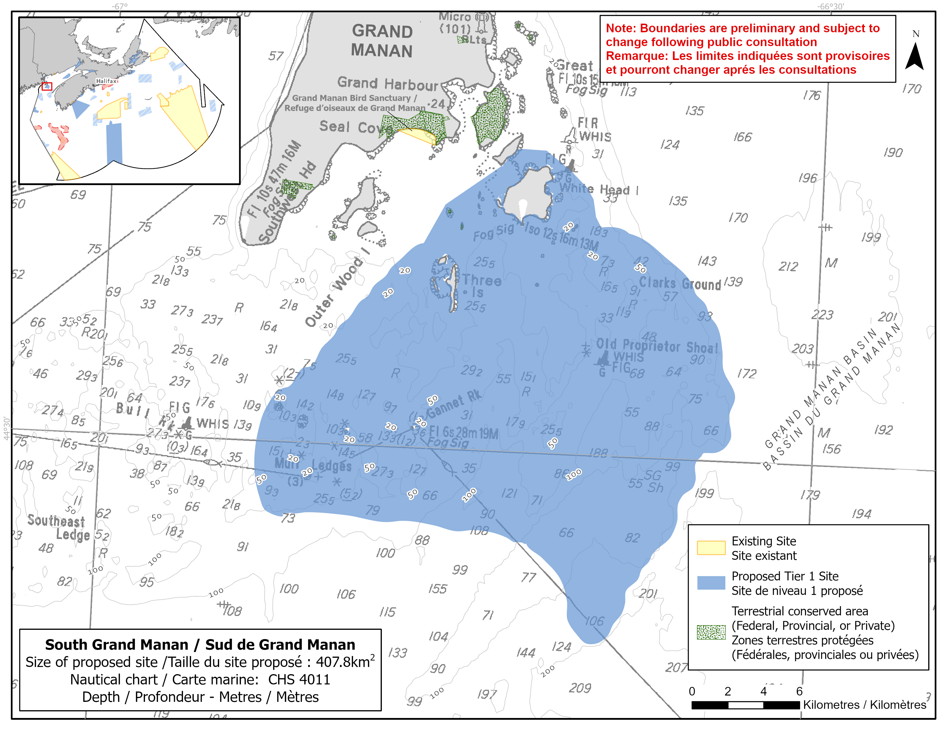
Map of proposed South Grand Manan network site
Simplified site coordinates
Boundaries are preliminary and subject to change following the public engagement.
| Point | Latitude | Longitude | Description |
|---|---|---|---|
| 1 | 44°38' 37.0" N | 66°43' 34.4" W | Starting at point 1 on the coastline of Cheney Island |
| 2 | 44°39' 8.5" N | 66°42' 52.0" W | Follow along Cheney Island coastline northeast to connect to point 2 |
| 3 | 44°39' 7.4" N | 66°41' 43.1" W | Connect to point 3, east of point 2 |
| 4 | 44°38' 3.9" N | 66°39' 56.6" W | Connect to point 4, southeast of point 3 |
| 5 | 44°36' 53.4" N | 66°39' 14.0" W | Connect to point 5, south of point 4 |
| 6 | 44°34' 44.1" N | 66°34' 46.1" W | Connect to point 6, southeast of point 5 |
| 7 | 44°30' 25.2" N | 66°33' 39.5" W | Connect to point 7, south of point 6 |
| 8 | 44°24' 20.0" N | 66°38' 54.7" W | Connect to point 8, southwest of point 7 |
| 9 | 44°27' 2.7" N | 66°41' 31.4" W | Connect to point 9, northwest of point 8 |
| 10 | 44°27' 54.7" N | 66°52' 51.3" W | Connect to point 10, west of point 9 |
| 11 | 44°30' 57.4" N | 66°53' 3.7" W | Connect to point 11, north of point 10 |
| 12 | 44°37' 21.9" N | 66°45' 52.7" W | Connect to point 12, northeast of point 11 and connect point 12 to point 1. |
Size
408 km2
Features
- Feeding area for whales and porpoises
- Important foraging area for seabirds, sea ducks and shorebirds
- Significant concentrations of marine plants
- Spawning area for haddock and Atlantic cod
- High fish and bird diversity
- Overlaps with a portion of the Grand Manan Archipelago Important Bird Area
- Nearby protections, including:
- North and South Green Islands Protected Natural Areas
- North Atlantic right whale critical habitat
- Grand Manan Migratory Bird Sanctuary
- Complex bottom topography
Species
This area supports species, including:
- Cetaceans, such as:
- North Atlantic right whale (listed as endangered under SARA)
- Fin whale (listed as special concern under SARA)
- Harbour porpoise (assessed as special concern by COSEWIC)
- Humpback whale
- Minke whale
- Depleted groundfish populations, such as:
- Atlantic cod (assessed as endangered by COSEWIC)
- Seabirds, sea ducks and shorebirds, such as:
- Red knot (listed as endangered under SARA)
- Red-necked phalarope (listed as special concern under SARA)
- Harlequin duck (listed as special concern under SARA)
- Kelp and rockweed
Use
- Current fisheries include bluefin tuna, crab, groundfish (fixed and mobile gear), herring (mobile gear), lobster, mackerel and scallop.
- Seaweed harvesting also occurs in the area.
- Licences issued to First Nations and Indigenous communities provide access to this area to fish for food, social and ceremonial purposes.
- There are several finfish aquaculture leases in the site.
- Recreational activities include:
- sea kayaking
- bird and whale watching
- A year-round ferry runs between Ingalls Head on Grand Manan and White Head Island.
- Date modified: