
Southern Bight
Southern Bight is proposed as a Tier 1 site for the Marine Conservation Network in the Scotian Shelf-Bay of Fundy Bioregion.
The lead agency for this site is Canadian Wildlife Service (Environment and Climate Change Canada).
In 2020, the Canadian Wildlife Service created an inner Bay of Fundy conservation planning team. The planning team is working to identify tools and approaches for conservation. Their work emphasizes best practice, transparency, accessibility, and participatory engagement. In 2023, the planning team identified protecting portions of the inner Bay of Fundy as a priority. For more information on this process, please contact enviroinfo@ec.gc.ca.
On this page
Location
Southern Bight is located in the southwest portion of Minas Basin and includes the tidally influenced portions of the Avon, Cornwallis, Gaspereau and St. Croix rivers.
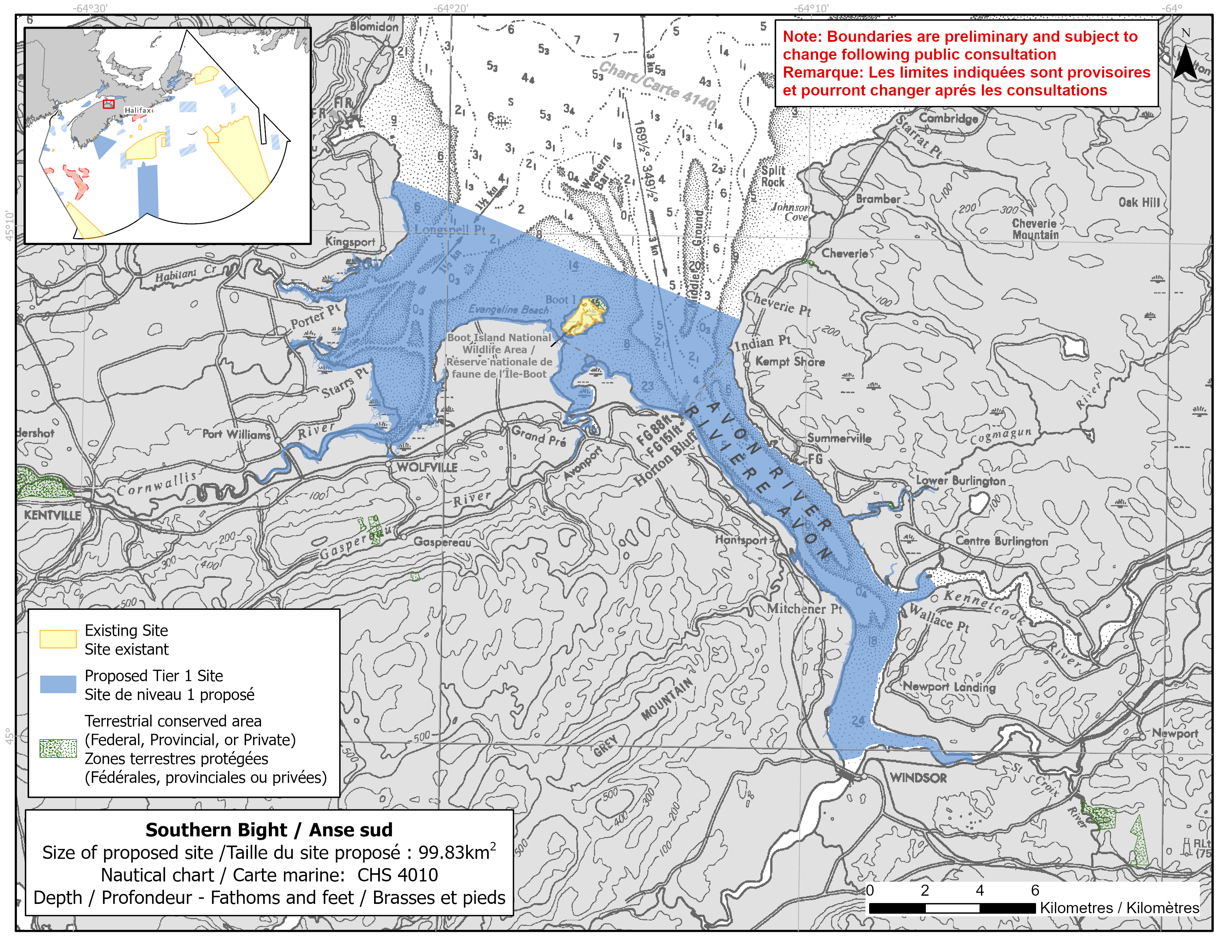
Map of proposed Southern Bight network site
Simplified site coordinates
Boundaries are preliminary and subject to change following the public engagement.
| Point | Latitude | Longitude | Description |
|---|---|---|---|
| 1 | 45°11' 1.2" N | 64°21' 29.2" W | Starting at point 1 on the coastline |
| 2 | 45°10' 59.4" N | 64°21' 18.2" W | Connect to point 2, southeast of point 1 |
| 3 | 45°8' 23.7" N | 64°11' 50.8" W | Connect to point 3, southeast of point 2 |
| 4 | 45°3' 32.1" N | 64°6' 38.5" W | Follow along the coastline southeast of point 3 to Kennetcook River (point 4) |
| 5 | 45°3' 11.6" N | 64°6' 17.9" W | Connect to point 5, southeast of point 4 |
| 6 | 44°59' 58.6" N | 64°5' 18.5" W | Follow along the coastline southwest of point 5 to St Croix River (point 6) |
| 7 | 44°59' 47.6" N | 64°5' 13.6" W | Connect to point 7, south of point 6 |
| 8 | 45°5' 36.6" N | 64°16' 27.7" W | Follow along the coastline west of point 7 to Gaspreau River (point 8) |
| 9 | 45°5' 37.3" N | 64°16' 31.4" W | Connect to 9, northwest of point 8 |
| 10 | 45°5' 1.3" N | 64°25' 0.3" W | Follow along the coastline north of point 9 to Cornwallis River (point 10) |
| 11 | 45°5' 3.9" N | 64°25' 5.0" W | Connect to 11, northwest of point 10 |
| 12 | 45°5' 14.2" N | 64°25' 12.9" W | Connect to 12, northwest of point 11 and connect point 12 to point 1 |
Size
100 km2
Features
- Important foraging area for seabirds, sea ducks and shorebirds
- Migratory stopover for shorebirds
- Significant concentrations of salt marsh and marine plants
- Spawning area for windowpane flounder, winter flounder, alewife, Atlantic silverside, Atlantic herring and lumpfish
- Juvenile and nursery area for fish including stickleback, Atlantic tomcod, Atlantic herring, Atlantic silverside and American shad
- Identified as an Important Bird Area, a Western Hemisphere Shorebird Reserve Network site and a Ramsar Wetland of International Importance
- Nearby protection, including:
- Boot Island National Wildlife Area
- Minas Basin Wildlife Management Area
- Critical habitat (freshwater) for Inner Bay of Fundy Atlantic salmon
- High productivity due to mudflats
Species
This area supports species including:
- Inner Bay of Fundy Atlantic salmon (listed as endangered under SARA)
- Atlantic mud-piddock (listed as threatened under SARA)
- Atlantic sturgeon (assessed as threatened by COSEWIC), Alewife and American shad
- Lumpfish (assessed as threatened by COSEWIC), Atlantic herring, Atlantic tomcod, Windowpane flounder and Winter flounder
- American eel (assessed as threatened by COSEWIC)
- Seabirds, sea ducks and shorebirds, such as:
- Piping plover (listed as endangered under SARA)
- Red knot (listed as endangered under SARA)
- Semipalmated sandpiper
- Salt marsh and kelp
Use
- Current fisheries include groundfish (fixed and mobile gear) and lobster. Other nearshore, small-scale fisheries for eel, gaspereau, herring and other species also occur.
- Bloodworm harvesting also occurs.
- Licences issued to First Nations and Indigenous communities provide access to this area to fish for food, social and ceremonial purposes.
- There is an experimental shellfish aquaculture lease in the site.
- Recreational activities include:
- bird watching
- hiking
- recreational fishing
- Extensive agriculture, including dyking, takes place on adjacent lands.
- Date modified: