
St. Mary’s (Napu’saqnuk) River and Estuary
St. Mary’s River (Napu’saqnuk) and estuary is proposed as a Tier 1 site for the Marine Conservation Network in the Scotian Shelf-Bay of Fundy Bioregion.
The lead agency for this site is Fisheries and Oceans Canada (DFO).
On this page
Location
The Napu’saqnuk is located about 200 km from Kjipuktuk (Halifax). The watershed and estuary are in the Eskikewa’kik district of Mi'kma'ki.
The proposed site includes the river, other wetted areas and potentially riparian zones on Crown Land. It does not include the entire watershed area.
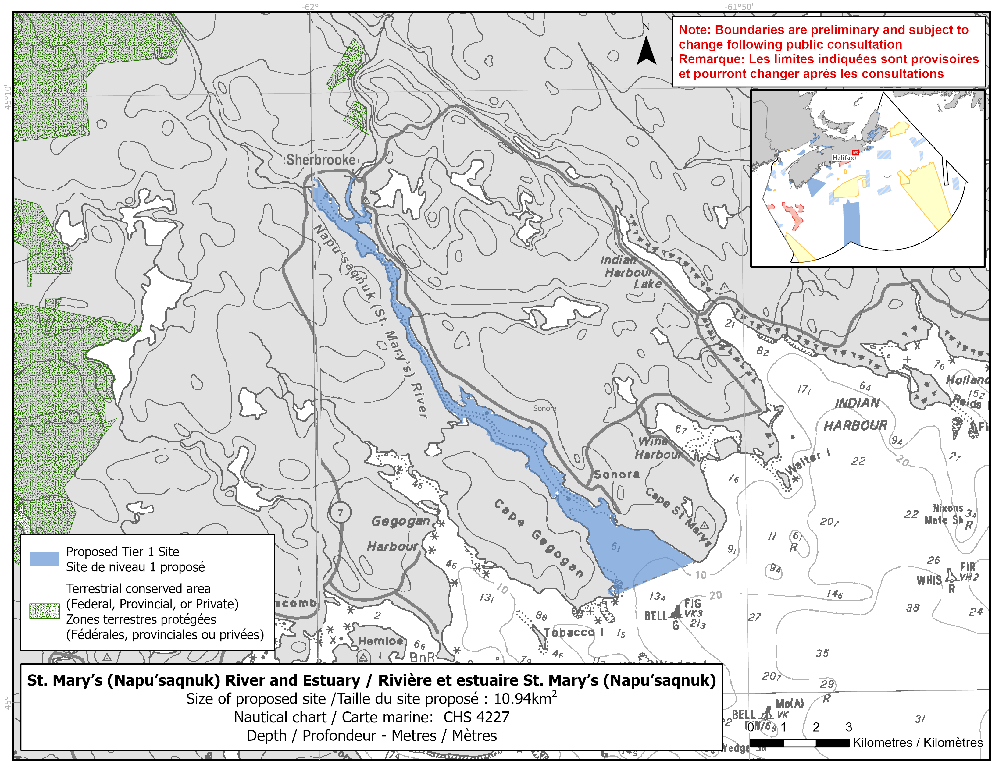
Map of proposed St. Mary’s River (Napu’saqnuk) and Estuary network site
Simplified site coordinates
Boundaries are preliminary and subject to change following the public engagement.
| Point | Latitude | Longitude | Description |
|---|---|---|---|
| 1 | 45°8' 36.193" N | 61°58' 59.247" W | Starting at point 1 on the river edge by the bridge |
| 2 | 45°2' 11.601" N | 61°51' 12.823" W | Connect to point 2, northeast of point 1 |
| 3 | 45°1' 39.996" N | 61°53' 1.367" W | Follow along the river edge, southwest of point 2 to point 3 on the coastline |
| 4 | 45°1' 40.279" N | 61°53' 3.019" W | Connect to point 4, southwest of point 3 |
| 5 | 45°8' 37.799" N | 61°59' 2.174" W | Connect to point 5 on the coastline, west of point 4 and follow the river’s edge to connect point 5 and point 1 |
Size
About 160 km2 of water could be protected, including 10.94 km2 of the estuary.
Features
- Highly important river for Nova Scotia Southern Upland Atlantic salmon
- The river is used as an index river by DFO Science to monitor this population
- Large populations of at-risk freshwater turtles
- Presence of salt marsh, marine plants and lichens
- Nearby terrestrial protection, including:
- Archibald Lake Wilderness Area
- High relative naturalness
- No dams impeding fish passage
- No known aquatic invasive species
Species
- Southern Upland Atlantic salmon (assessed as endangered by COSEWIC)
- Brook floater (listed as special concern under SARA)
- American eel (assessed as threatened by COSEWIC)
- Wood turtle (listed as threatened under SARA)
- Brook trout, gaspereau and rainbow smelt
- American lobster
- Eelgrass (Zostera marina and Rupia martima)
- Mainland moose (listed as endangered under the Nova Scotia Endangered Species Act)
- At-risk bird species, such as:
- Bank swallow
- Chimney swift
- Common nighthawk
- Evening grosbeak
Use
- The Mi'kmaq have historically used this river for travel, fishing, hunting and living.
- Napu'saqnuk is a place of cultural importance for the Mi'kmaq.
- Current fisheries include lobster. Coastal fishing, such as gaspereau, may also occur.
- Licences issued to First Nations and Indigenous communities provide access to this area to fish for food, social and ceremonial purposes.
- There are 219 active mineral exploration licenses in the watershed and no active mines.
- Recreational activities include:
- boating
- kayaking
- recreational angling
- There is a small craft harbour in the Sonora estuary.
- Forestry and agricultural practices take place in the watershed.
- Date modified: