
West Isles and Passages
West Isles and Passages is proposed as a Tier 1 site for the Marine Conservation Network in the Scotian Shelf-Bay of Fundy Bioregion.
The lead agency for this site is Fisheries and Oceans Canada.
On this page
Location
West Isles and Passages is located off southwest New Brunswick (in an area also known as the Quoddy Region, Quoddy Isles or Fundy Isles). The site includes the waters around McMaster, Pendleton, Deer, Campobello and other nearby islands. Big Letete and Little Letete Passages, which are channels north of Deer Island and Western Passage, between Deer Island and Maine, are included.
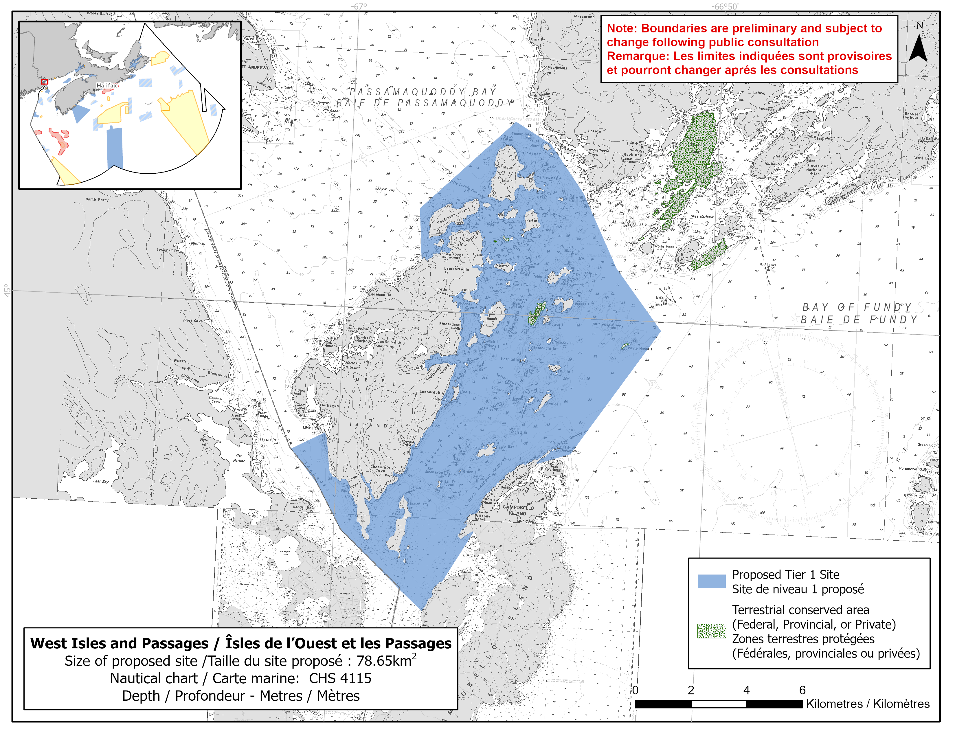
Map of proposed West Isles and Passages network site
Simplified site coordinates
Boundaries are preliminary and subject to change following the public engagement.
| Point | Latitude | Longitude | Description |
|---|---|---|---|
| 1 | 45°0' 57.2" N | 66°57' 57.3" W | Starting at point 1 on the coastline on Deer Island |
| 2 | 45°1' 59.0" N | 66°58' 4.4" W | Connect to point 2, north of point 1 |
| 3 | 45°3' 45.0" N | 66°55' 33.9" W | Connect to point 3, northeast of point 2 |
| 4 | 45°3' 20.9" N | 66°54' 35.2" W | Connect to point 4, southeast of point 3 |
| 5 | 45°2' 25.3" N | 66°53' 37.5" W | Connect to point 5, southeast of point 4 |
| 6 | 45°1' 0.6" N | 66°52' 38.1" W | Connect to point 6, southeast of point 5 |
| 7 | 44°59' 50.0" N | 66°51' 20.2" W | Connect to point 7, southeast of point 6 |
| 8 | 44°57' 22.1" N | 66°53' 38.9" W | Connect to point 8, southwest of point 7 |
| 9 | 44°57' 8.6" N | 66°54' 34.4" W | Connect to point 9, southwest of point 8 |
| 10 | 44°55' 46.5" N | 66°56' 10.7" W | Follow along Campobello Island coastline northeast to connect to point 10 |
| 11 | 44°54' 46.7" N | 66°56' 58.5" W | Connect to point 11, southwest of point 10 |
| 12 | 44°54' 11.4" N | 66°57' 29.0" W | Follow along Campobello Island coastline southwest to connect to point 12 on the Canada/US boundary |
| 13 | 44°57' 13.0" N | 67°1' 15.7" W | Follow the Canada/US boundary north to point 13 |
| 14 | 44°57' 32.5" N | 67°0' 24.6" W | Connect to point 14 on the coastline of Deer Island, northeast of point 13 and follow the coastline north to connect point 14 to point 1 |
Size
79 km2
Features
- Significant concentrations of habitat-forming sponges
- Feeding and nursery area for whales and porpoises
- Important foraging area for seabirds, sea ducks and shorebirds
- Significant concentrations of marine plants
- Spawning area for lumpfish
- Nursery area for redfish and Atlantic cod
- High benthic invertebrate, marine mammal and bird diversity
- High productivity due to areas of persistent upwelling
- High secondary productivity with large concentrations of copepods and krill
- Nearby terrestrial protections, including:
- Clark Gregory Nature Reserve
- Western Isles Nature Reserve
- Complex bottom topography
Species
This area supports species, including:
- Cetaceans, such as:
- North Atlantic right whale (listed as endangered under SARA)
- Fin whale (listed as special concern under SARA)
- Harbour porpoise (assessed as special concern by COSEWIC)
- Humpback whale
- Minke whale
- Depleted groundfish populations, such as:
- Atlantic cod (assessed as endangered by COSEWIC)
- Atlantic wolffish (listed as special concern under SARA)
- Lumpfish (assessed as threatened by COSEWIC)
- Seabirds, sea ducks and shorebirds, such as:
- Red-necked phalarope (listed as special concern under SARA)
- Dabbling ducks
- Herons
- Northern gannet
- Habitat-forming sponges
- Kelp and rockweed
- Stalked tunicates (also known as sea potatoes)
- Copepods and krill
Use
- Current fisheries include crab, groundfish (fixed and mobile gear), herring (fixed gear), lobster, scallop and sea cucumber.
- Shellfish and seaweed harvesting also occur in the area.
- Licences issued to First Nations and Indigenous communities provide access to this area to fish for food, social and ceremonial purposes.
- There are several finfish aquaculture leases and lobster pounds in the site.
- Recreational activities include:
- bird and whale watching
- scuba diving
- recreational fishing
- A year-round ferry connects Deer Island with L'Etete, New Brunswick.
- A seasonal ferry connects Deer Island with Campobello Island.
- Large cargo vessels travel to and from the Port of Bayside through Head Harbour Passage and along the western side of Deer Island.
- An underwater power cable runs between Deer Island and Campobello Island.
- Date modified: