
Marine Spatial Planning Framework for the Newfoundland and Labrador region
This document (the framework) outlines a methodology for advancing marine spatial planning (MSP) in the Newfoundland and Labrador (NL) Region, including support for the development and implementation of area-specific plans, activities and initiatives. It serves as a guide to support decision-making and policy development to support and improve the management and sustainable use of our ocean resources and space. The MSP process aims to enhance coordination between ocean users and authorities and increase our knowledge about the ocean environment and activities.
The framework specifically lays out a process for development of tools and strategies to enhance ocean planning coordination, inform decision-making and improve compatibility of ocean uses. This can be achieved through utilizing existing authorities and legal frameworks, using the best available information and promoting best practices in decision-making. The framework is a foundation for advancing marine planning priorities and will continue to evolve as new information, needs and trends emerge.
On this page
- Overview
- National direction
- Regional approach
- Ecological, economic and socio-cultural overview
- Advancing MSP
- Appendix A - Relevant acts
Overview
The framework is the foundation on which to build robust tools and actions for ocean planning that promotes sustainable ocean development and conservation into the future. Below is a summary of the framework indicating how elements of the MSP process can be advanced.
Marine Spatial Planning (MSP) is a process for understanding and organizing where, when and how humans use the ocean to ensure that people benefit and that the ocean is healthy.
What this framework does:
- establish a regional process
- provide guidance to regulators
- inform decision making
What this framework does not do:
- establish maritime zones
- replace existing authorities
- make management decisions
An approach to collaborative governance and participation
The MSP process establishes governance structures and supports active participation of partners and stakeholders.
The framework provides the context for current MSP governance and engagement structure being utilized in the region. Outlined are mechanisms and strategies for working with partners and stakeholders, including:
- government departments
- Indigenous Governments and Organizations
- industry sectors
- non-governmental organizations
- other marine users and experts.
These approaches can be used to gather important insights into further developing and implementing MSP activities and can be utilized by marine authorities during their decision-making processes.
An approach to integrating science and knowledge
The MSP process collects and integrates data from governments and external sources, including Indigenous and local knowledge, and produces accessible maps that show human activities and ecological features.
The framework provides context for the importance of marine geospatial data and information and an overview of the decision support tools and initiatives being developed that may assist marine planning practitioners and decision makers. Of particular significance to the success of MSP is the Canada Marine Planning Atlas and associated knowledge products. The framework also highlights the importance of diverse sources and types of information, including scientific, Indigenous and local knowledge, and academic- and industry-sourced.
An approach to spatial analysis and planning
The MSP process evaluates and analyzes scientific, economic and socio-cultural information to inform decision-making.
The framework provides context for the current ecological, economic and socio-cultural landscape in the region, including potential drivers for MSP:
- factors influencing or impacting decisions
- emerging economic activities
- government mandates
- conservation directives
- etc.
Analyzing current and emerging activities can help identify potential conflicts and knowledge gaps that can be addressed and considered in management, policy development and decision-making within a defined marine space.
National direction
Marine spatial planning (MSP) is a collaborative process aimed at managing ocean spaces to achieve ecological, economic and socio-cultural objectives. It involves the coordination of various stakeholders, regulatory authorities, and interested parties to ensure responsible use of the marine space. Key characteristics of MSP include:
- adaptability
- ecosystem focus
- integration
- locality
- strategic thinking
- public participation
Marine spatial plans can come in various forms and are often accompanied by complementary materials to support the MSP process. As MSP is an iterative process, it can generate multiple generations of plans that evolve over time. In Canada, the process to date has focused on establishing first-generation marine spatial plans, which sets the foundation for ongoing collaborative planning efforts and outlines steps taken and expected outcomes. This framework serves as a first-generation marine spatial plan for the NL region.
In Canada, MSP currently does not replace the regulatory responsibilities of existing authorities but rather fosters collaboration to establish:
- a shared vision
- principles
- knowledge base
- decision-making tools
The framework further guides regional MSP processes and activities, including development of more comprehensive marine spatial plans. Such plans can inform when, where and how management actions should occur to achieve specific goals and objectives while considering existing, expanding, and emerging ocean uses, as well as areas requiring added protection measures for long-term environmental resilience and sustainability.
Canada's approach to MSP
The international approach to MSP processes and plan development varies due to factors such as political drivers, conservation concerns and priority developments. Generally, these can result in plans that serve several purposes:
- Policy framework: align policies, define overarching goals and offer guidance for MSP.
- Regulatory coordination: harmonize regulatory authorities to coordinate the management of ocean resources.
- Legislated zoning: incorporate legislated zoning, establishing legally binding boundaries to delineate ocean uses.
In Canada, MSP reflects elements of these international approaches but does not replace the regulatory responsibilities of existing authorities. Any form of legislated zoning is the responsibility of relevant authorities and would require extensive time, collaboration and consensus among all affected parties. Incorporating comprehensive legislated zoning in marine spatial plans is currently outside the scope of work in Canada and is not the current approach outlined in this framework.
Canada's approach to MSP was guided by an internally developed Fisheries and Oceans Canada (DFO) process that ensured national MSP consistency and transparency. This process is aligned with guidance from the Intergovernmental Oceanographic Commission of UNESCO and considered the Canadian context. It outlines a series of potential activities across flexible and iterative phases for MSP development, from pre-planning to implementation. The process supported discussions with partners for regionally relevant processes and necessitates coordination and partnerships with ocean authorities, which demand substantial investments in time and resources.
Each DFO administrative region advancing MSP was expected to develop a first-generation marine spatial plan (or planning framework) to meet Canada's 2024 MSP commitment. While these plans may not provide recommendations for specific management actions, they identify:
- approaches for future marine planning
- integrated management activities and processes
First-generation plans reflect Canada's commitment to working with federal, provincial, territorial and Indigenous partners, and other interested parties to enable the advancement of shared interests and priorities. As such, implementing first-generation plans would rely on collaboration among MSP partners and stakeholders to realize DFO's intentions for developing a process to uphold national MSP principles.
National MSP principles
To ensure uniformity in Canada's approach to MSP across planning regions, a set of national principles was established. These align with Canada's broader principles for integrated management and served as a foundation for the development of MSP processes across the country.
The MSP process is implemented differently worldwide but generally adheres to a set of guiding principles. These principles encompass both universally accepted collaborative planning principles and those tailored to specific local considerations. The presence of these guiding principles is essential for the success of MSP, as they establish a framework for defining MSP objectives and encourage constructive engagement among MSP partners and stakeholders.
- Ecosystem-Based
- Ecosystem-based MSP ensures that ecosystem sustainability and function is of primary importance in MSP processes.
- Evidence-Based
- Evidence-based MSP ensures that processes are informed by the best available information from diverse scientific disciplines, Indigenous Knowledge holdings and other knowledge bases, including that of partners and stakeholders as appropriate.
- Participatory
- Participatory MSP ensures that processes are conducted in a manner that is inclusive and actively engages partners and stakeholders, enabling full, efficient, and transparent consideration of concerns and interests.
- Respect
- Respect for existing rights and activities ensures that MSP can progress within the current legislative, regulatory and policy context of Canada.
- Sustainable Development
- Sustainable development ensures that environmental, economic, social and cultural values are considered, with the aim of meeting present needs without compromising the ability of future generations to meet their needs.
- Transparency
- Transparency ensures that MSP processes can be easily understood by the public by openly sharing how work is completed, how decisions are made, how resources have been allocated and how decisions may affect the public.
National MSP goals
Canada's established goals for MSP strive to manage and balance diverse and often competing interests in marine areas, ensuring the sustainable use and conservation of these valuable environments.
Enable integrated oceans management
- establish collaborative arrangements with provinces, territories and Indigenous Peoples
- coordinate across ocean authorities to manage ocean uses such that conflicts among existing, expanding and emerging ocean uses can be minimized and compatibilities optimized
- compile an integrated evidence-base, including information from diverse scientific disciplines, local and experiential knowledge, and Indigenous Knowledge, as well as the development of decision-support tools
- advance environmental, economic, social and cultural objectives
Respect regional diversity
- acknowledge that circumstances, partners and priorities with respect to ocean governance and management vary across local, sub-regional and regional scales
- ensure a degree of national consistency across MSP processes while respecting regional diversity
Legislative and regulatory context
Sections 91 and 92 of the Canadian Constitution Act (1867) delineate the division of powers between the federal and provincial governments in CanadaFootnote 1. Section 91 grants the federal government legislative authority over marine areas, fisheries and certain aspects of marine pollution and environmental protection within Canadian borders. Specifically, the federal government's jurisdiction extends from the ordinary low watermark seaward to 200 nautical miles. Other environmental matters, like those pertaining to coastal waters from the ordinary low watermark inland, wastewater, rivers and lakes, fall within provincial jurisdiction.
Coastal and ocean management at the federal level involves collaboration among multiple departments. The primary aim of MSP at the federal level would be to reduce conflicts between various ocean uses, enhance decision-making efficiency and promote evidence-based decision-making.
Under the authority of the Oceans Act (1996), MSP serves as a collaborative process through which integrated oceans management (IOM) may be achievedFootnote 2. Canada's legislative foundation for IOM lies within Part II, Section 31 of the Oceans Act, which authorizes the Minister of Fisheries, Oceans and the Canadian Coast Guard (the Minister) to lead and facilitate the development and implementation of integrated management plans in collaboration with:
- provincial, territorial and Indigenous governments
- other federal departments and agencies
- stakeholders located in or affecting Canada's coastal and marine environment
In addition, Section 32 enables the Minister to establish marine environmental quality guidelines, objectives and criteria to support IOM.
The Canada's Oceans Strategy (2002) serves as the guiding policy for managing the country's oceans and defines IOM as an ongoing process for making decisions that promote sustainable use, development, and protection of marine areas and resourcesFootnote 3. IOM recognizes the interconnectedness of different marine activities and their potential environmental impacts, aiming to overcome the limitations of sectoral management by fostering cooperation and harmonization among various stakeholders.
While DFO lacks the legal authority to regulate all ocean uses, it leads the development of MSP under IOM. Therefore, MSP in Canada is not legally binding and would not replace the regulatory responsibilities of existing authorities or their respective management roles in the marine environment. Instead, authorities involved in the process should collaborate, drawing on their own respective legislation and authorities.
MSP interacts with various policies at different levels, including those of DFO related to:
- Indigenous fisheries
- sustainable fisheries
- fish and fish habitat
- marine conservation
- integrated management.
Additionally, MSP intersects with policies beyond the DFO, covering:
- conservation
- marine transportation
- climate change
- Indigenous governance
- and more
MSP seeks to add value to planning processes and decision-making through improved coordination and collaboration. Essentially, MSP convenes and relies on the tools of all regulatory authorities in the ocean space to enable information sharing and decision-making that is comprehensive, integrated, and complementary for ocean sectors, activities and concerns.
Effective MSP requires cross-sectoral, multi-jurisdictional and interdepartmental policy coordination to advance and implement its objectives successfully. For more information on key ocean authorities (federal, provincial, Indigenous) that oversee how Canada's oceans are used and regulated (relevant to the NL region), refer to Appendix A.
Indigenous reconciliation
The Government of Canada is dedicated to achieving reconciliation with Indigenous Peoples through respectful and cooperative relationships. This commitment is based on principles such as:
- reconciliation
- recognition of rights
- respect
- cooperation
- partnership
Several legislative and policy frameworks guide this effort, including Section 35 of the Canadian Constitution Act (1982)Footnote 4, the United Nations Declaration on the Rights of Indigenous Peoples (UNDRIP) ActFootnote 5 and the DFO-Canadian Coast Guard Reconciliation StrategyFootnote 6.
The Truth and Reconciliation Commission of Canada (TRC)Footnote 7 defines reconciliation as “establishing and maintaining a mutually respectful relationship between Aboriginal and non-Aboriginal peoples in this country where there is an awareness of the past, an acknowledgement of the harm that has been inflicted, atonement for the causes, and action to change behaviour”.
The UNDRIP Act mandates the Canadian government to work with Indigenous Peoples, addressing injustices and discrimination while developing an action plan. While it doesn't immediately change DFO operations, it encourages building on existing processes and partnerships to collaborate with Indigenous Peoples on fisheries and aquatic resource issues, ensuring their voices are heard.
DFO's Reconciliation Strategy commits the department to recognizing and implementing Indigenous and Treaty Rights related to fisheries, oceans, aquatic habitat, and marine waterways in accordance with Section 35 of the Constitution Act, UNDRIP Act and federal Principles Respecting the Government of Canada's Relationship with Indigenous Peoples. The strategy aims to strengthen Indigenous-Crown relationships, promote self-determination and reduce socio-economic disparities.
DFO engages with Indigenous Governments and Organizations through collaborative arrangements, like the Fisheries Joint Management Committee and Fisheries Governance Structures. These arrangements are crucial for advancing collaborative governance, including IOM and MSP.
Indigenous Peoples have a significant role in managing marine and coastal areas within their traditional territories. They have a history of collaborating to balance multiple interests while protecting the marine environment and its ecosystems. While acknowledging these contributions and aligning with reconciliation goals, there is growing recognition both nationally and internationally of the need to involve Indigenous Peoples as partners in marine and coastal planning, conservation and management.
How MSP supports Canada's ocean agenda
Ocean sustainability:
- MSP supports sustainable growth within various ocean sectors, aligning with the Federal Sustainable Development Strategy Goal #14 "to conserve and protect Canada's oceans".Footnote 8 It assists in achieving targets related to protected areas, minimizing loss of natural habitats and biodiversity, and sustaining fish stocks
- MSP identifies suitable areas for economic activities while minimizing conflicts and enhancing compatibility among different ocean uses. This approach fosters resilient, sustainable, and forward-looking ocean spaces, aligning with Canada's vision of a sustainable ocean economy
Ocean protection:
- MSP can help identify areas that require protection or special measures, aligning with Canada's marine conservation targets to conserve 25% of marine and coastal areas by 2025 and 30% by 2030Footnote 9. As well, in considering the Global Biodiversity Target #1, “… areas are planned or managed to bring loss of areas of high biodiversity importance close to zero”Footnote 10
- MSP and other biodiversity-inclusive planning would be pivotal for achieving the entire range of biodiversity-related targets, from reducing threats to enabling sustainable use
Ocean governance and reconciliation:
- MSP can establish collaborative arrangements with provinces, territories, Indigenous partners, and other stakeholders, facilitating better coordination of ocean governance efforts
- MSP would be a primary mechanism for Indigenous Peoples to participate in ocean management and planning, aligning with the DFO-Coast Guard Reconciliation Strategy
- MSP adheres to the principles guiding the Government of Canada's relationship with Indigenous Peoples, and thus could contribute to reconciliation efforts in the marine context
Regional approach
Overview
MSP has been undertaken in several planning areas across CanadaFootnote 11. Within the NL region, the Newfoundland-Labrador (N-L) Shelves BioregionFootnote 12 (Figure 1) was identified as a preliminary planning area to advance MSP. 3 main deliverables, to be completed by 2024, included:
- the development of bioregional governance structure(s)
- publicly accessible interactive map(s)
- regional MSP generation 1 plans (frameworks)
The NL region also borders the Estuary and Gulf of St. Lawrence (EGSL) Bioregion (Figure 1). While MSP activities for that bioregion have been led through a separate process (in coordination with the DFO Regions of Gulf and Quebec), the governance and engagement structures, support tools and approaches outlined in this document can be applied throughout the entire NL region, independent of planning area.
The framework and the companion interactive mapping tool, Canada Marine Planning Atlas (the atlas)Footnote 13, serves as the foundation for continued progress of MSP in the region. The framework's emphasis on:
- improved coverage and diversity of data
- intergovernmental coordination and governance
- stakeholder engagement
- establishing shared vision and priorities
- supports regional MSP goals
- establishing objectives
Planning areas within NL region
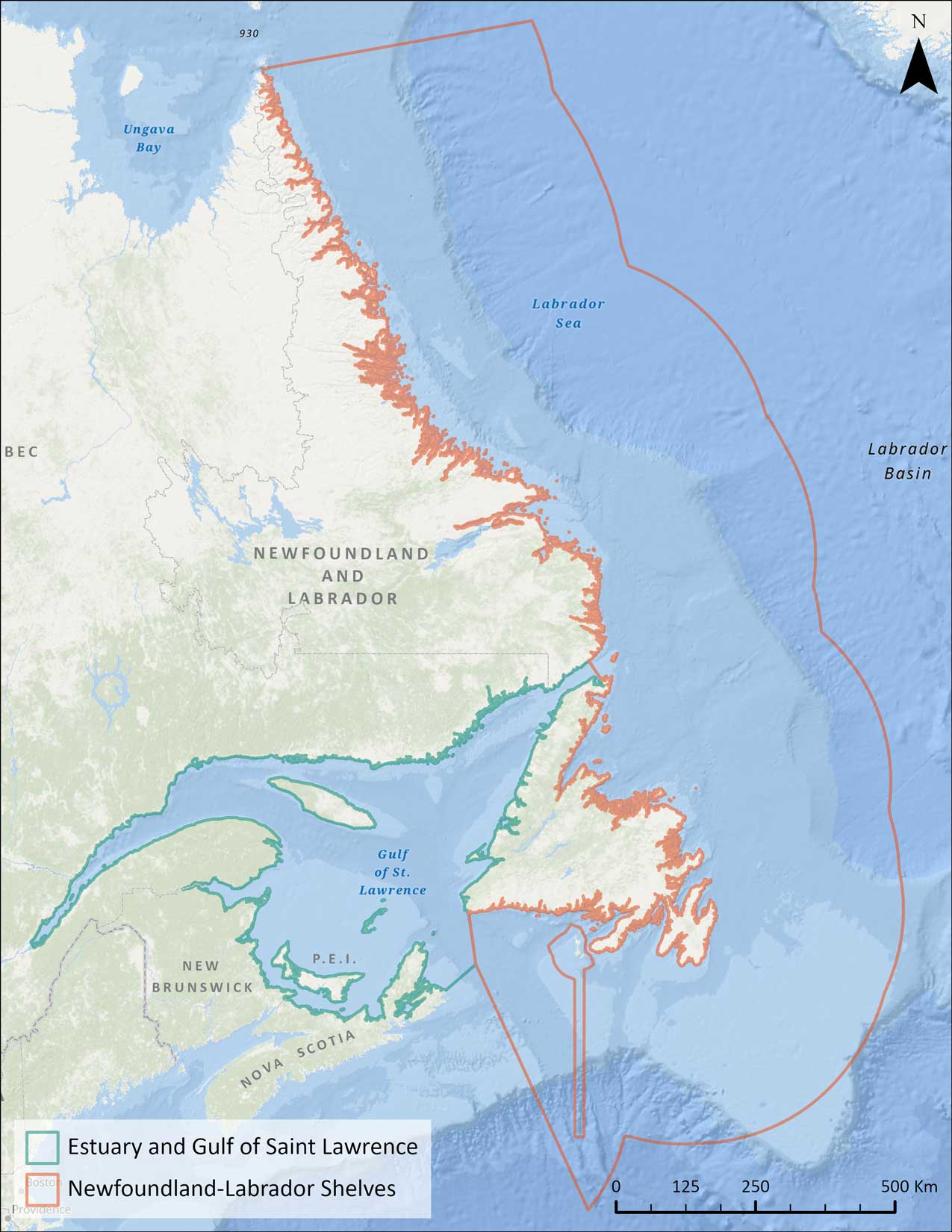
Figure 1 - DFO Marine bioregions in the NL region
The Newfoundland-Labrador (N-L) Shelves Bioregion covers approximately 1 million square kilometers, extending from Cape Chidley at the northern tip of Labrador to the southern Grand Banks and the south coast of Newfoundland. This large and diverse bioregion extends offshore to the limit of Canada's Exclusive Economic Zone and inshore to the high-water mark.
Estuary and Gulf of St. Lawrence (EGSL) Bioregion encompasses the estuary and gulf formed by the St. Lawrence River as it meets the Atlantic Ocean, encompassing parts of the provinces of:
- Quebec
- Prince Edward Island
- New Brunswick
- Nova Scotia
- Newfoundland and Labrador
The St. Lawrence River serves as a major conduit for fresh water, nutrients and sediments, playing a crucial role in shaping the marine and coastal ecosystems within the bioregion. The St. Lawrence Seaway is a vital transportation corridor that enhances trade, facilitates economic growth and fosters international cooperation in maritime transportation.
3 DFO administrative regions—Gulf, Quebec and NL—jointly coordinate the EGSL planning area with other regulatory authorities. Each DFO region engages and collaborates with various Indigenous Governments and Organizations and stakeholders. Opportunities for collaboration on MSP are also identified through diverse federal and provincial processes. The framework only applies to the portion of EGSL bioregion that falls within the NL region.
Increased human and economic activity within bioregions has resulted in competition for marine space in some areas. Building more resilient systems and developing plans and policies to mitigate the effects of pollution, climate change, and overexploitation is critical to the long-term health of ocean ecosystems. This situation has created a need for enhanced planning and coordination of marine space use which MSP can provide.
Regional planning context
DFO's Marine Planning and Conservation (MPC) Program was established to fulfill Canada's Oceans Act commitments concerning ocean management. Lessons were garnered from early initiatives like managing Large Ocean Management Areas (LOMAs)Footnote 14, coastal management areas across the region and designating Oceans Act Marine Protected Areas (MPAs)Footnote 15. Substantial expertise has been developed, particularly in:
- oceans and coastal management
- conservation planning
- engagement and collaboration
- decision support
- spatial data analysis using Geographic Information Systems (GIS) and Marxan, a software tool that guides systematic multi-objective planning, often for conservation
Crucial insights from these experiences have influenced the present approach to MSP. The current approach emphasizes collaborative work by:
- empowering others to engage in the process
- enhancing communication and transparency
- delivering tangible outcomes
This includes providing timely and accessible information and tools to support improved planning and decision-making for DFO and other stakeholders.
The Placentia Bay/Grand Banks (PBGB) and Gulf of St. Lawrence LOMAs were 2 of the 5 priority areas in Canada identified for IOM. Under this initiative, plans were established from 2012 to 2017 for:
- long-term direction
- common basis for development and implementation to support environmental, social, cultural, and economic sustainability
This initiative validated the possibility and desirability of IOM in NL. The lessons learned, stakeholder relationships established and data collected through the LOMA initiative have been vital to the development of an MSP approach in the region.
Linkages with some of the federal and provincial policies, programs and initiatives that relate to an ecological, economic and socio-cultural MSP context are further explored in the Ecological, economic and socio-cultural section. A review of relevant government mandates with implications for advancing a comprehensive, coordinated and adaptive approach to managing marine resources and activities within the NL region have been explored through the various MSP governance mechanism discussed below and will be further highlighted when advancing IOM activities.
The Labrador Inuit Land Claims Agreement (LILCA)Footnote 16, a modern-day Treaty between the Inuit of Labrador, the Province of NL, and Canada, outlines aspects for Ocean Management. The Nunatsiavut Government's ‘Imappivut' is a plan to manage and protect Labrador Inuit interests in the coastal and marine areas of Labrador and implements Chapter 6 of the LILCAFootnote 17.
Imappivut means “our oceans” in English and was designed to represent the relationship that Labrador Inuit have with coastal and marine areas. The plan is guided by the values, knowledge, and interests of Labrador Inuit, celebrates the connections Inuit people have with the marine environment, and works to contribute to the health and wellbeing of Labrador Inuit.
Regional vision for MSP
A coordinated approach to promoting healthy and productive marine ecosystems that support sustainable economic, social and traditional activities to benefit current and future generations
Informed decisions
- Spatial data and other knowledge products focusing on ecological, economic and socio-cultural priorities are incorporated into decision-making
- Information and policy gaps related to coastal and ocean management, conservation and ocean use are identified and prioritized for action
Enhanced coordination
- Communication and engagement strategies include a broad range of ocean users and interests
- Needs and priorities of marine authorities, Indigenous peoples and stakeholders are identified
Improved compatibility of ocean uses
- Understanding of past, present and future marine resource interactions, impacts and ocean use is increased
- Regional issues, new and emerging human activities, and conservation opportunities are assessed
Tools and strategies
- The Canada Marine Planning Atlas, in addition to other knowledge products and decision support tools, provides up-to-date spatial information and data to decision makers
- The regional MSP Governance and Engagement Structure and Mechanisms enhances coordination of decisions and policy development by relevant authorities
- The regional MSP approaches outlined in the framework for establishing ecological, economic and socio-cultural priorities help address gaps, identify synergies and provide guidance to relevant authorities
Governance structure
Effective and collaborative governance, including partners, is an essential element of IOM and is instrumental in developing shared visions, goals and priorities for MSP processes. Collaborative governance for MSP also includes federal coordination (inter- and intra-departmental) to articulate roles, responsibilities and authorities of federal MSP partners to ensure shared accountability and inform a national approach to evolving MSP initiatives and processes.
As the federal lead for oceans management and marine conservation, DFO is committed to working cooperatively with partners and has made concerted efforts toward improving collaborative governance of Canada's 3 oceans, while also advancing the Government of Canada's agenda for reconciliation with Indigenous Peoples. One of the ways DFO would uphold these commitments through IOM is by creating opportunities for early, frequent, and sustained involvement throughout the MSP process, to the furthest extent possible. This governance approach reflects the transparency and participatory principles as described in the National direction section.
The governance of MSP in the NL region was established through the existing federal/provincial structuresFootnote 18. The Regional Oversight Committee on Ocean Management (ROCOM) as well as the Canada/NL Committee on Ocean Management (CNLCOM) are in place and active within the NL region since the mid-2000s. The ROCOM is the senior executive forum for federal and provincial government departments having a mandate or an interest in ocean activities to provide oversight, coordination and direction to coastal and ocean planning and management processes in NL. The Deputy Minister of the Government of NL Department of Fisheries, Forestry and Agriculture (FFA), and the Regional Director General of DFO-NL region co-chair the ROCOM. Advancing MSP using this governance structure was discussed with Indigenous partners and it was agreed to collaborate bilaterally through ROCOM and associated structures as required. The co-chairs of ROCOM approved this governance approach in April of 2020 and assigned CNLCOM responsibility for MSP development and implementation in the region. To fulfil this responsibility, CNLCOM, through establishment of various working groups, will seek input from Indigenous Governments and Organizations and other stakeholders. Regional discussions of IOM activities will continue at the ROCOM with partners.
Numerous governance structures were also put in place to coordinate federal collaboration and information sharing within DFO, both within the region and between regions, and with other government departments. This included:
- MSP working groups at multiple management levels, comprised of various DFO sectors within the region
- MPC
- Science
- Resource Management
- Policy and Economics
- working groups with MPC in other DFO regions advancing MSP initiatives
These structures provided for information sharing, guidance and approvals.
Overview of MSP governance mechanisms
Federal-provincial governance
Forums for information sharing, coordination and direction on ocean-related matters including MSP processes and activities within federal and provincial departments and agencies with a role or an interest in ocean management in the province.
- Regional Oversight Committee on Oceans Management (Senior Management)
- Canada-NL Committee on Oceans Management (Directors)
- MSP Working Groups (Practitioners) as needed
Indigenous partnerships
Bilateral meetings and agreements with Nunatsiavut Government, Innu Nation, NunatuKavut Community Council, Qalipu and Miawpukek First Nation, to share information, seek input and give direction into the development of MSP products and plans, including identifying opportunities for data sharing.
Federal coordination
Information sharing, coordination, and direction on the MSP process, activities, and priorities.
DFO-NL Sectors with a role in supporting MSP
- MPC Coordination Committee (Directors/Managers)
- MSP Intersectoral Working Group (Practitioners)
DFO Regions led by MPC Program in the National Capital Region
- MPC Committee (Directors)
- MSP Managers Circle*/National Oceans Management Committee (Managers)
- MSP Practitioners Working Group* (Practitioners)
*Sunset in 2024
Federal departments with a role or an interest in MSP
- Atlantic (MSP) Coordination Table (Managers/Practitioners)
EGSL Bioregion internal DFO governance, led by DFO Gulf Region and supported by DFO-NL and DFO-QC MPC Programs
- Steering Committee (Directors)
- Coordinating Committee (Managers)
- MSP Working Group (Practitioners)
Engagement context and approach
Towards effective stakeholder participation and improved communications in the MSP process.
Engagement of partners and stakeholders is critical to successful MSP. An MSP External Engagement working group was established under CNLCOM to assist with the external process of advancing the MSP initiative with:
- Indigenous Governments and Organizations
- marine industry
- environmental non-government organizations (ENGOs)
- other stakeholders
The External Engagement WG met regularly to review engagement processes and provided advice on engagement schedules and opportunities.
Engagement activities, including data and information sharing, are essential for the MSP process. As key partners in the process, Indigenous Governments and Organizations were engaged in early planning with a focus on multi-year funding opportunities to increase their capacity for involvement, including Indigenous Knowledge collection and considerations.
The initial external engagement for the framework was done through a phased approach over 3 years from 2020 to 2023, where each of the 3 phases had specific goals and outcomes. The 3 phases focused on:
- initial engagement and information
- priority setting and associated data acquisitions and needs
- the atlas and framework development
MSP partner and stakeholder engagement timelines
Phase 1 (2020 to 2021): Initial engagement and information
- Focused on establishing basis for developing MSP with partners and defining the process and approach with key stakeholders
Outcomes:
- Developed federal/provincial partnership to lead engagement
- Formed collaborative relationship with Indigenous Governments and Organizations
- Held info sessions on concepts and processes
Phase 2 (2021 to 2022): priorities and data acquisition and needs
- Focused on establishing priorities to help inform data discussions, user needs, and support tool development
Outcomes:
- Discussed vision and goals for the regional process
- Gathered input on regional priorities and approach
- Identified data holders and essential datasets and needs
Phase 3 (2022 to 2023): framework and atlas development
- Focused on promoting and contributing to the atlas and drafting of the MSP Framework
Outcomes:
- Promoted use of the atlas to inform improvements on functionality
- Defined and filled gaps in data and map products
- Collected feedback on MSP scope and next steps
Stakeholder engagement is a crucial component of advancing MSP to effectively address the diverse needs and concerns of stakeholders. Implementing an adaptive management approach that allows for adjustments to MSP processes based on feedback and changing circumstances is essential.
By integrating stakeholder engagement into MSP processes in a meaningful and collaborative manner, MSP can achieve informed decisions and enhance the overall quality and acceptance of decisions and plans, which can lead to more successful outcomes. The engagement mechanisms and strategies outlined may evolve and adapt as marine planning processes are advanced.
Engagement mechanisms
MSP is a multi-level process that requires engaging a diverse range of stakeholders at various stages. A variety of mechanisms were used to ensure effective and meaningful engagement with partners and stakeholders. Different sectors and stakeholder groups require methods of engagement that are accustomed to their unique needs. This includes:
- bilateral discussions
- workshops
- technical forums
- information sessions aimed at reaching a range of audiences
- working groups
- questionnaires
- training and funding support
- communication and education materials
Documenting engagement sessions is important to build on previous discussions, address concerns and improve the effectiveness of stakeholder involvement. The engagement process provides the opportunity for inclusion of Indigenous Knowledge, local knowledge, external science and multidisciplinary science in the MSP process. Also, understanding the relationships between our partners and stakeholders may help avoid potential conflicts while providing opportunities for different sectors to work together to share ideas and concerns.
Engagement partners and stakeholders
Indigenous Governments and Organizations
Initial engagement with Indigenous Governments and Organizations was completed through bilateral discussions. Multi-year funding opportunities were provided to help build capacity to participate in the development and governance of MSP.
Marine Industry Stakeholders
Marine industry associations and representatives were invited to attend MSP engagement sessions. Sector groups included those from the commercial fishing, aquaculture, energy, tourism and recreation, and shipping industries.
Environmental Non-Governmental Organizations (ENGOs)
Various ENGOs operate within the province with a focus on coastal and ocean issues. Some are engaged on a national scale in federal ocean initiatives. Within the region, these organizations, along with several smaller, localized groups, promote and carry out activities related to:
- coastal and ocean conservation
- habitat restoration
- species protection
- public education and awareness
Several of these organizations participate in a DFO-ENGO caucus which meets semi-annually. Members of the caucus were updated throughout the process.
Other Interested Stakeholders, Users and Expertise
The MSP process is multi-level and requires engagement of a variety of stakeholders at various stages. Groups or individuals not included in the 3 other categories may be engaged as MSP evolves. For example, the academic community may supply additional data, may identify and fill data gaps, and are experts in ocean management topics and research. Municipalities and coastal communities have an abundance of local, cultural and socio-economic information related to coastal communities and planning efforts, as well as associated issues, and provide a channel to reach the public through community engagement.
Data collaboration and information sharing
As discussed in the previous section, effective engagement and collaboration is central to successful MSP processes. Updated and accurate data provide a basis for these informed discussions and foster transparency and inclusiveness in the planning process.
- maintaining and updating data for MSP is fundamental for informed decision-making, sustainable management of marine resources, compliance with regulations, effective risk assessment, and inclusive stakeholder engagement—all of which are essential for the long-term health and sustainability of marine ecosystems and the communities that depend on them
- marine ecosystems are dynamic and can change over time due to natural processes, climate change, or other factors. Regular data updates help capture these changes, enabling planners to understand evolving ecosystem dynamics
- human activities in the marine environment, such as shipping, fishing, tourism, and energy production, are constantly evolving. Timely and accurate data updates allow planners to assess the impacts of these activities on the marine environment and effectively allocate and manage marine resources and space to ensure sustainable use and minimize conflicts
- keeping data up-to-date helps in compliance with existing regulations and policies to govern marine activities by ensuring that planning decisions align with the latest environmental and legal requirements
- understanding risks related to natural disasters (e.g., storms) and human-induced hazards (e.g., oil spills) is vital for planning resilient marine areas. Current data enables effective risk assessment and the implementation of measures to enhance the resilience of the marine ecosystem and communities that rely on it
Addressing gaps in knowledge
Coastal communities rely heavily on coastal and marine resources and that is reflected in the substantial management attention they receive. A considerable proportion of fish, bird and mammal species, along with their habitats, are closely monitored, managed and protected through various federal and provincial laws and programs. Data and information play an important role in these management processes, and, while the NL region is data rich in many regards, it is limited in some respects given the size of the marine area. Depths beyond 1500 meters and in northern areas are often poorly studied and there is often a gap in scope and availability of data for the coastal zone. Limited time and resources make the vast expanse and diversity of localized and historical information sometimes difficult to incorporate. Exploring options to collaborate with research institutions, local communities and governmental bodies to conduct targeted studies addressing data gaps is required.
In addition to ecological data, social and cultural information are important in the management of ocean resources and use. Limited spatial data in relation to recreational activities, areas of cultural significance and the social values placed on coastal areas by residents make incorporation of diverse interests challenging. Concentrated efforts to fill data gaps and explore methodologies to capture these types of information is an important part of MSP processes. Providing additional information on overlapping human stressors will further efforts to understand cumulative impacts on marine ecosystems. Engaging with experts to refine methodologies and approaches for analyzing socio-cultural information is beneficial to MSP processes.
Gaps in policy and programs can be identified through discussing MSP governance and by examining best practices from other regions and countries. Understanding and providing clarification on the roles and responsibilities of key ocean authorities and users can help highlight areas of overlap, coordinate and streamline decision-making processes, and identify areas of efficiency.
Ultimately, MSP can help address questions concerning the marine environment, its stakeholders, and the various governance mechanisms by relying upon a diverse array of information to form an evidence-based foundation. This information often requires analysis or synthesis to be fully utilized in effective MSP processes and has been termed ‘knowledge products' (KPs).
Knowledge products
MSP seeks to coordinate information, ideally from multiple and diverse sources, including government, marine sector interests and Indigenous peoples. KPs can serve as tools to support the MSP process, as they are developed and tailored to meet the needs of the region. National coordination on methodologies can help ensure consistency in adjacent or overlapping areas.
The development of KPs is cyclical in nature. As resolutions to MSP questions take shape, new questions may emerge, necessitating new information and new KPs. Ultimately the aim is to improve the decision-making process. National mapping products being developed for MSP include those for marine commercial use density and for ecologically and socio-culturally important areas. Regional efforts are also underway to support the continued development of products and layers for inclusion in the atlas to fill spatial knowledge gaps.
A centralized location to search data and information relevant for ocean management decision makers is also being explored within DFO. This can be used to help identify available datasets and those missing and allow digital assets to be organized, classified, validated, synthesized and prioritized to ensure quality and discoverability for MSP purposes.
Decision support tools and initiatives
Outlined below are some of the decision support tools developed within DFO and by other federal partners, to improve existing decision-making processes. Continued input from partners and stakeholders may be sought to:
- further develop these, and other required tools
- identify opportunities to collaborate
- fill gaps in data and related analyses
Canada Marine Planning Atlas
The Canada Marine Planning Atlas (the atlas) was released publicly on January 31, 2023. The atlas is an interactive mapping tool which supports IOM by supplying decision-makers, stakeholders, and the public with access to relevant MSP information on economic, ecological and socio-cultural activities occurring in Canada's marine spaces. The atlas has been developed through collaboration with many DFO sectors and branches and with input from internal and external partners and stakeholders. The atlas allows users to discover, view, interact with, and download geospatial data relevant to MSP. Information on how to use the current version of the atlas, contribute data and provide feedback on improvements can be found by accessing the atlas directly.
The atlas is of use to decision-makers at the federal, provincial, and municipal levels and Indigenous Governments and Organizations. It has also been designed to be relevant and useful to other users, such as:
- academia
- industry
- educational institutions
- non-governmental organizations
- research institutions
- the public
The atlas possesses built-in functionalities, and its data layers are accessible for download and use beyond the confines of the application, serving diverse purposes. The atlas represents a user-friendly, interactive web mapping tool with core functionalities for:
- navigation
- location-based searches
- side-by-side comparisons
- printing
- bookmarking
- measuring
Moreover, a reporting feature is available to distill pertinent information within a user-defined geographical area.
The data repository spans many themes, including Ecosystem and Ocean Knowledge and Human Use. Additionally, an extensive array of supplementary data layers can be accessed through Canada's Open Data PortalFootnote 19 and other data sites that support data sharing, transparency and access.
Atlas benefits
- Improving access to science-based ocean data
- Increasing transparency
- Aiding in conflict resolution
- Identifying information gaps
Marine/ Ocean Use Compatibility Matrix
The Marine/Ocean Use Compatibility Matrix was developed internally to assess the degree to which various human activities and uses can coexist in our ocean environment. These activities include:
- marine transportation
- fishing
- aquaculture
- oil and gas operations
- tourism
- infrastructure development
- research undertakings
- Indigenous practices
- conservation efforts
- protective measures
This methodology draws inspiration from the approach developed by DFO in the Maritimes region, which in turn was influenced by decision support tools originating in Europe.
Each marine activity is evaluated based on 4 fundamental criteria:
- spatial extent
- timing
- vertical reach
- mobility
Scores are combined of 2 activities based on a defined rule set to determine potential compatibility or conflict among the human uses and activities across the marine and coastal environment. The outcome provides an overarching perspective on the alignment and possible tensions in the interplay of human activities and uses within these dynamic coastal and marine settings.
Community-based Coastal Resource Inventory (CCRI)
The Community-based Coastal Resource Inventory (CCRI) was introduced in 1997 to collect local knowledge and perspectives on the location of coastal species and resource activity around the provinceFootnote 20. It was designed to assist in filling knowledge gaps in the coastal zone and supplement existing data. Local teams were hired to interview residents and marine users and complete a spatial inventory.
This dataset is currently being updated and expanded, using new digital technologies and will provide a valuable source of local knowledge to use in MSP and other decision-making processes. While the initial focus was on mapping ecological resources, the update will also include information on other marine activities and identify changing priorities and emerging issues. Publishing of these datasets will be explored to make them available through the atlas.
Coastal Community Conservation Opportunities Initiative (CCCOI)
The Coastal Community Conservation Opportunities Initiative (CCCOI) is a DFO NL-led initiative aimed:
- at promoting local conversations on conservation
- to ascertain information from those who live and work in coastal areas
- to identify priorities and interest
This supports transparent and inclusive planning for marine conservation and informs decision-making by exploring potential areas of overlap between government and stakeholder activities to assist in the identification of sites. The engagements undertaken by the CCCOI help to identify socio-economic, cultural and ecologically important areas, and provide a foundation for coastal community involvement in MSP processes. This work is supported by the local knowledge collection through the CCRI initiative and supports the delivery of spatial data layers for use in the atlas.
Indigenous Knowledge Projects
There are ongoing efforts within DFO to work with Indigenous Governments and Organizations to support the collection, mapping and inclusion of Indigenous Knowledge across the region. This provides increased technical capacity within communities and fosters continued dialogue on filling knowledge gaps.
Cumulative effects
Historically, the impacts of anthropogenic activities in the marine environment have been assessed independently from one another. However, within DFO, there has been a national focus to understand how exposure to overlapping anthropogenic stressors can amplify their impact. Efforts are underway to generate cumulative effects models, with regions in various stages of development. Generally, existing work has used spatial data layers representing stressors and habitats and vulnerability matrices scoring the degree of impact each stressor is likely to have on a habitat as inputs to quantify the cumulative impact of stressors within the modelled area. The NL region had preliminary discussions on this work and can draw from existing methodologies and expertise where regionally appropriate.
Coastal Environmental Baseline Program (CEBP)
The Coastal Environment Baseline Program (CEBP) was established in 2017 as one of the initiatives under the Oceans Protection PlanFootnote 21. The program's goal is to collect baseline data to :
- allow the characterization of the current state of key coastal ecosystems, identified as being subject to high or increasing vessel traffic or coastal development
In the NL region, this includes Placentia Bay and Fortune Bay. Using a collaborative partner engagement approach, the program supports the establishment of a baseline understanding of these ecosystems in sufficient detail to allow future ecosystem changes to be measured and to provide data which can be used to support informed decision-making.
Projects funded through the CEBP collect data on Target Ecosystem Components (TEC), the scientific data collection priorities identified for each study site, developed collaboratively with:
- partners
- local communities
- rights holders
- stakeholders
These TEC include physical and oceanographic components, as well as biological components. Once collected, data is made open and accessible to allow use in environmental impact assessments, management planning, research and other applications.
Other federal activities
Other federal departments listed below have been funded to support the MSP initiative through the development of KP and mapping products, as well as filling marine spatial data and information gaps.
Environment and Climate Change Canada (ECCC)
Environment and Climate Change Canada's (ECCC) Canadian Wildlife Service (CWS) is working to make the best available marine bird information more accessible, including data on:
- seabirds
- shorebirds
- waterfowl that are found in offshore, coastal, and/or intertidal waters
Migratory bird habitats are being considered in ECCC's efforts to fill temporal, spatial, and/or species-specific data gaps and update and produce data products that are identified as priorities.
Keeping existing data layers and information up-to-date, including within the atlas, helps to:
- inform monitoring plans
- ensures biodiversity-inclusive planning and ECCC's contribution to the Oceans Protection Program
- assist with the management and potential impacts from existing and future human activitiesFootnote 22
Natural Resources Canada (NRCan)
Natural Resources Canada (NRCan) is providing regional geoscience products to support the MSP process and evidence-based decision-making. This work contributes marine geoscience information to regional assessments to better inform project developments on environmental conditions, site suitability and potential cumulative impacts. NRCan's MSP products are made up of publicly accessible maps/data layers including:
- geophysical surveys
- geological analysis
- sediment mobility
- seabed photographs
- video transects
The MSP program has collaborated with NRCan's Surveyor General Branch and the DFO-Canadian Hydrographic Service (CHS) on the establishment of authoritative and legally defined boundaries within a Marine Cadastre, a federal tool designed to systematically record all legally recognized rights, responsibilities, and restrictions pertaining to the ocean space. This initiative is part of a larger effort to enhance marine spatial governance.
Transport Canada (TC)
Transport Canada (TC) has many programs, policies, initiatives and priorities that contribute expertise, information, knowledge or data to MSP processes. As administrator of Canada's Marine Safety System, TC participation in MSP processes ensures the planning process is aligned with the department's legislative and regulatory requirements related to marine shipping. TC is working closely with Indigenous peoples, coastal communities and stakeholders on a number of initiatives under Canada's Oceans Protection Plan 2.0. The outcomes of these initiatives may also inform the planning process and be integrated into the atlas.
Ecological, economic and socio-cultural overview
Overview
As stated in the National direction section, MSP is a collaborative process aimed at managing ocean spaces to achieve ecological, economic and socio-cultural objectives. Several mechanisms have been pursued to protect ocean space within the NL region while minimizing impact on important economic activity. Through greater involvement and engagement with coastal communities and Indigenous Governments and Organizations, the identification of ocean areas with socio-cultural importance can also be considered in decision-making processes.
By understanding the current ecological, economic and socio-cultural landscape, considering overarching drivers (factors influencing or impacting decisions), and addressing data gaps, MSP can become a robust tool for ocean planning to promote sustainable marine resource management and conservation.
Ecological context
Biophysical overview
The Newfoundland-Labrador (N-L) Shelves bioregion and Estuary and Gulf of St. Lawrence (EGSL) bioregionFootnote 23 are biogeographic units relevant for the NL region primarily based on oceanographic and bathymetric similaritiesFootnote 24. The N-L Shelves bioregion features a broad and shallow continental shelf, ranging from approximately 100 km off the coast of Labrador to over 600 km off the east coast of Newfoundland. This shelf is occasionally intersected by deeper troughs and channels with parts of the Grand Bank varying in depth from less than 50 m to 400 m. Beyond the shelf edge, the ocean floor plunges to depths exceeding 2,000 m.
EGSL bioregion is one of the largest estuarine ecosystems in Canada and the world. It covers 236,000 km2 and is surrounded by 5 Canadian provinces. The Gulf of St. Lawrence has a relatively shallow average depth compared to other oceanic basins with depths typically ranging from around 20 m in the shallower areas to over 300 m in deeper regions. However, there are some areas where the depth can reach over 1,000 m, such as in the Laurentian Channel. The EGSL bioregion is also influenced by the:
- Great Lakes basin
- St. Lawrence River
- Canadian Shield hydrographic system
Oceanography
2 major oceanographic currents in the northwest Atlantic affect the climate and marine ecosystems in the region:
- the Labrador Current
- the North Atlantic Current
The Labrador Current, which flows southward along the coast of Labrador and the northeast coast of Newfoundland, primarily governs the oceanographic conditions of the N-L Shelves. This current brings cool Arctic water to the N-L Shelves, while the North Atlantic Current transports warm water from the Gulf Stream into the North Atlantic. The confluence of these 2 currents creates a vital zone of high productivity along the Grand Banks of Newfoundland, supporting various regional ecosystems.
Areas and species of significance
Regional knowledge of areas and species with important ecological and biological roles has led to the delineation of Ecologically and Biologically Significant AreasFootnote 25 (EBSAs: Figure 2) and Significant Benthic Areas (SiBAs: Figure 3), as well as the identification of Ecologically Significant Species (ESS). Identification and designation of EBSAs, SiBAs and ESS are recognized both nationally and internationally as a potentially useful tool for aquatic resource conservation, management and planning. EBSAs are areas within Canada's oceans that have been identified through formal scientific assessments as having biological or ecological significance when compared with the surrounding marine ecosystem. There are 31 EBSAs identified within the regionFootnote 26 (Figure 2).
SiBAs are significant areas of cold-water corals and sponge dominated communitiesFootnote 27 (Figure 3). Corals and sponges are affiliated with the most species-rich habitats of deep-water marine ecosystems. Their structure provides areas for other species to:
- rest
- feed
- spawn
- avoid predators
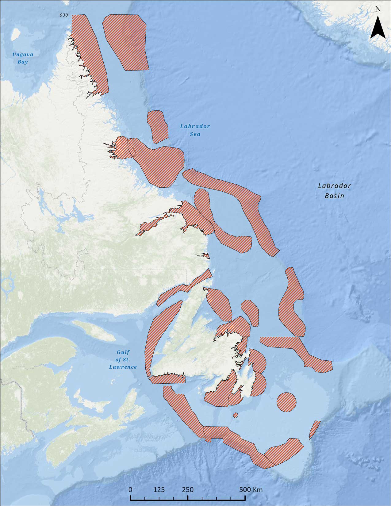
Figure 2 - Ecologically and Biologically Significant Areas (EBSAs) in the NL region
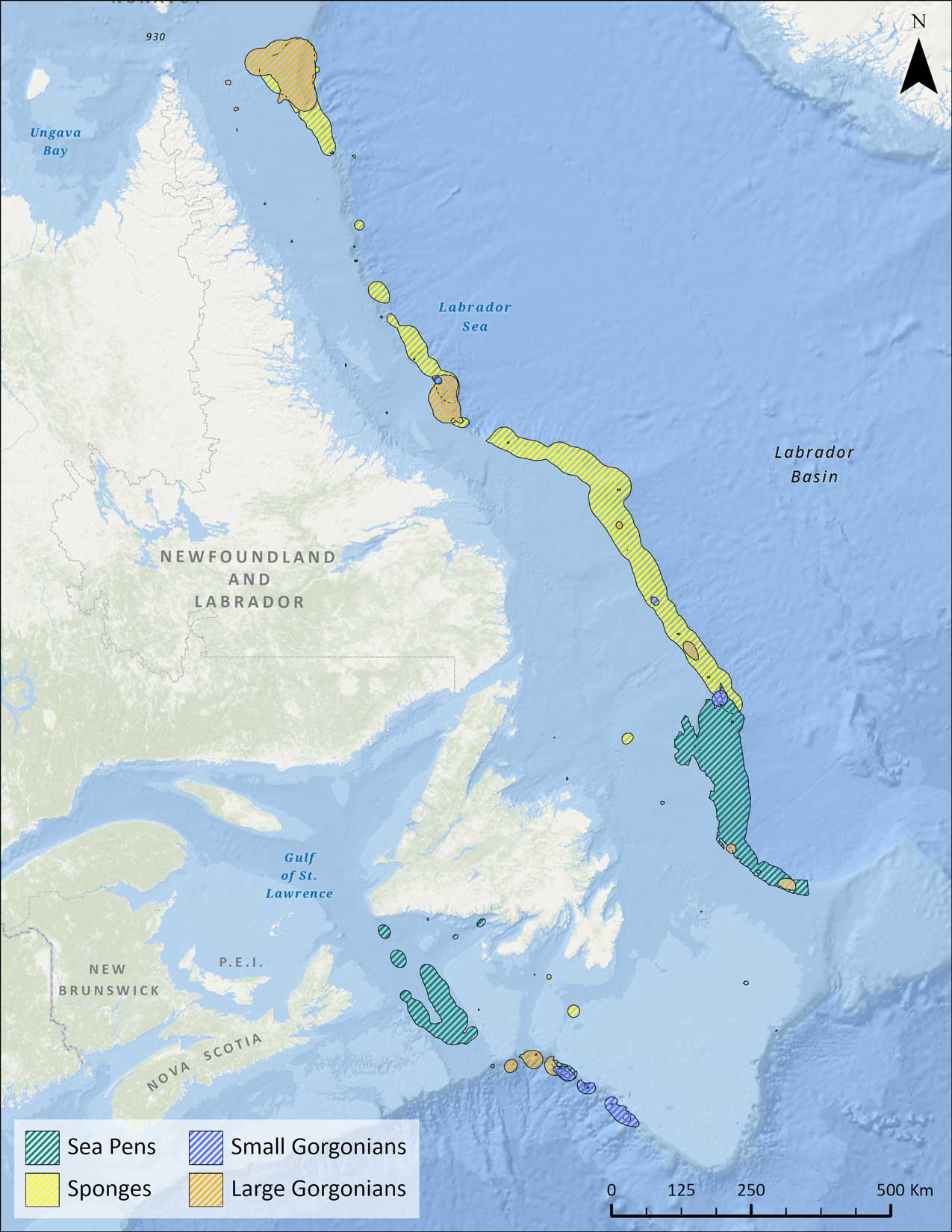
Figure 3 - Significant Benthic Areas (SiBAs) in the NL region
They may also provide protection for eggs and juveniles of various species. Sponges contribute significantly to the nitrogen, carbon and silicon cycles in the oceanFootnote 28.
The identification of ESS is a tool for bringing attention to any species that has particularly high ecological significance. As such, enhanced protection should be provided to species that are significant to maintaining ecosystem structure and functionFootnote 29. Given the many ecosystem services provided, including carbon sequestration, eelgrass has been designated an ESS in CanadaFootnote 30. There may be additional ESS in the region that have not yet been identified and there are other non-ESS species present that still hold ecological significance in the area.
Eelgrass: an ecologically significant species in the region
Eelgrass plays a crucial role in the coastal ecosystem, mainly along the Atlantic coast in bays and coastal waters. These beds, recognized as highly productive ecosystems globally, serve as vital nursery habitats for various fish, invertebrates and other algae, providing an abundant food supply. Additionally, eelgrass serves as a significant food source for birds and other species.
Unfortunately, eelgrass beds along the Atlantic coast have witnessed a decline in recent decades due to factors such as:
- coastal development
- eutrophication
- the presence of invasive species
While comprehensive data for the entire coast is limited, some locations have reported declines ranging from 30 percent to 90 percentFootnote 31.
The National Eelgrass Task Force (NETForce) is a collaborative partnership of scientists, managers, and stakeholders in Canada working towards creating a publicly accessible and dynamic national map of eelgrass distribution. The data, collected since 1987, utilizes various mapping techniques, including satellite imagery and LiDAR. The National Eelgrass Dataset for Canada is comprehensive, incorporates data from different partners, and includes information such as eelgrass percentage cover and density. The map aims to be continuously updated with ongoing contributions from various organizations.
Marine conservation mechanisms
Marine protected areas and other effective area-based conservation measures are tools that play an important role in maintaining sustainable fish stocks, as well as protecting ecologically significant habitats for marine mammals and other species (Figure 4).
Oceans Act Marine Protected Areas (MPAs)
Oceans Act Marine Protected Areas (MPAs) are established by DFO to protect and conserve:
- marine species
- habitats
- ecosystems
There are 3 MPAs in the region:
- Laurentian Channel
- Gilbert Bay
- Eastport
MPAs may allow some current and future activities depending on their impacts to the conservation objectives being protected. For most new federal MPAs established after April 25, 2019, the Government of Canada plans to prohibit the following activities, with limited exceptions:
- oil and gas exploration, development and production
- mineral exploration and exploitation
- disposal of waste and other matter
- dumping of fill
- deposit of deleterious drugs and pesticides
- fishing via bottom-trawl gear
Proposed additional limitations or prohibitions include the intent to enhance restrictions on certain vessel discharges while vessels are within MPAs. The final parameters of these restrictions will be developed by Transport Canada in consultation with stakeholders and will take technical and operational limitations into consideration.
National Marine Conservation Areas (NMCAs)
Canada currently has 5 National Marine Conservation Areas (NMCAs)Footnote 32. An NMCA's primary purpose is to safeguard and conserve representative marine regions for the benefit, education, and enjoyment of both Canadians and the global community. These areas offer enjoyable experiences for visitors, promote awareness and understanding among Canadians and deliver benefits to Indigenous peoples and coastal communities.
In 2021, Parks Canada (PC) pledged to establish 10 new marine NMCAs and 4 new freshwater NMCAs over the next 5 years. These establishments will be done by collaborating with Indigenous Government and Organizations on cooperative management agreements for these areas and engaging with other government departments and stakeholders.
NMCAs encompass:
- submerged lands
- the water above them
- the species residing there
- wetlands
- estuaries
- islands
- coastal lands
There are 2 proposed marine NMCAs in the region:
- one in the Southcoast Fjords
- one adjacent to Torngat Mountains National Park
National Wildlife Areas (NWAs) and Migratory Bird Sanctuaries (MBS)
National Wildlife Areas (NWAs) and Migratory Bird Sanctuaries (MBS) are established by ECCC and are for wildlife conservation, research and interpretationFootnote 33. There are currently 3 sanctuaries in the region:
- Terra Nova
- Ile aux Canes
- Shepherd Island
Partnerships and engagements with stakeholders are ongoing on potential establishment of future NWAs on the province's southeast Avalon.
Seabird Ecological Reserves
Seabird Ecological Reserves are established by the Government of NL under the provincial Wilderness and Ecological Reserves Act and protect diverse seabird coloniesFootnote 34. These Ecological Reserves are found in the region:
- Baccalieu Island
- Witless Bay
- Cape St. Mary's
- Funk Island
- Hare Bay Islands
- Gannett Islands
- Lawn Bay Islands
Important Bird Areas (IBAs)
Important Bird Areas (IBAs) are places of international significance for the conservation of birds and biodiversityFootnote 35. In Canada, IBAs have been used to help establish conservation areas and have been used by governments to assess impacts and establish guidelines for proposed development projects. There are currently 41 IBAs in the region.
Key Biodiversity Areas (KBAs)
Key Biodiversity Areas (KBAs) are specific geographic regions that play a crucial role in preserving biodiversity both nationally and globally. These areas are identified using internationally recognized standards, and a National Standard for KBAs in Canada was established in 2021Footnote 36. Efforts to identify and assess KBA sites of global and national significance are ongoing in Canada. As part of this assessment process, Birds Canada is also reevaluating and converting IBAs into KBAs.
Marine Refuges
Marine Refuges are fisheries-area closures established under the Fisheries Act that meet the criteria in the Government of Canada's 2022 Marine OECM Guidance and are therefore recognized as OECMsFootnote 37. These measures help protect important species and their habitats, including unique corals and sponges, from the impacts of fishing. These measures are intended to be in place long-term to make a lasting contribution to biodiversity. N-L Shelves Marine Refuges include:
- Hatton Basin Closure (NAFO Division 2G portion)
- Hopedale Saddle Closure
- Hawke Channel Closure
- Funk Island Deep Closure
- Northeast Newfoundland Slope Closure
- 3O Coral Closure
Ecologically Significant Areas (ESAs)

Figure 4 - Marine Conservation Areas in the NL region
Ecologically Significant Areas (ESAs) are a spatial regulatory tool under the Fisheries Act intended to provide long-term protection and conservation of fish habitat that is sensitive, highly productive, rare or unique. ESAs are designated through Governor-in-Council regulations, and can be designated in freshwater, estuarine and marine environments.
- In 2023, the Fish and Fish Habitat Protection Program (FFHPP) published the framework for identifying, establishing and managing Ecologically Significant Areas
- A selection of potential areas for future ESA establishment was identified as case studies in freshwater and estuarine environments
- Further policy development and associated guidance is needed to inform ESA establishment.
- No ESAs have been designated in the region or in Canada and DFO has not yet identified whether or how ESAs may contribute to terrestrial (via freshwater) or marine conservation targets.
- DFO will continue to work with Indigenous Peoples, provinces and territories, and other interested parties to determine which potential ESA candidates will be put forward for advancement and associated next steps
Conservation planning
Marine conservation targets
Canada has made considerable progress protecting the oceans and meeting marine conservation targets (MCTs). Canada is also a vocal advocate for advancing the protection of the global ocean:
- In 2010, Parties to the United Nations Convention on Biological Diversity (UN CBD) committed to the Strategic Plan for Biodiversity 2011-2020, including Aichi Biodiversity TargetsFootnote 38
- Aichi Target 11 committed UN CBD Parties to conserve 10 percent of coastal and marine areas globally through effectively managed networks of MPAs and OECMs by 2020
- In support of this global target, Canada committed to conserving 10 percent of coastal and marine areas nationally
- In 2024, Canada had protected and conserved over 15 percent, surpassing its target and is now committed to conserving 30 percent by 2030
National marine conservation networks
A conservation network is a collection of MPAs and other conserved areas that cooperate to safeguard important ecological components of the ocean and marine biodiversity as a whole. Development of bioregional networks includes engagement and collaboration with:
- provincial and territorial government agencies
- Indigenous Governments and Organizations
- stakeholders
- other interested parties
The potential for negative socio-economic impacts of bioregional networks will be considered and efforts made to mitigate them. Once a bioregional network plan with sites is finalized, appropriate conservation measures and identification of responsible authorities, site-specific planning, and implementation occurs.
While the N-L Shelves Bioregional Conservation Network design has not been finalized, options are being explored on how best to incorporate relevant information from the draft design into MSP processes. The MPA Network Strategy for EGSL was released in 2017 and conservation planning will be carried out with partners moving forward.
Natural areas planning
The Protected Areas PlanFootnote 39 for the Island of Newfoundland is a roadmap for achieving provincial and international goals for the conservation of nature. As of 2023, 6.9 percent of Newfoundland and Labrador is under protection. Through protected areas planning, efforts are underway to protect more wilderness and species. Proposed ecological reserves that are under consideration for protection include several coastal areas as well as seabird reserves with marine components.
Other conservation initiatives
Marine environmental quality (MEQ) program
The Marine Environmental Quality (MEQ) program within DFO has authority under the Oceans Act to use a variety of non-regulatory and regulatory tools, to assess and manage human activities and their potential risks to species and their ecosystems, such as:
- objectives
- criteria
- guidelines
- standards
- requirements
Across Canada, the program supports other planning and conservation initiatives such as MSP by developing management measures and providing advice. MEQ efforts in NL region are currently focused on underwater noise and marine debris ecosystem stressors. The national MEQ program is leading the development of Canada's Ocean Noise Strategy to:
- better understand the complex threat of ocean noise
- build on existing knowledge and resources
- coordinate actions
- guide future partnerships and initiatives to minimize impacts on marine life
MSP approaches can be used to address human-generated noise and its effects on Canada's marine environments, such as identifying overlap between habitats of noise-sensitive species and ocean areas with elevated noise.
Species at Risk Act (SARA)
The Species at Risk Act (SARA) was designed to protect and conserve wildlife species at risk in CanadaFootnote 40. Numerous aquatic species are covered by this Act, including:
- blue whales
- leatherback sea turtles
- piping plovers
The Act plays a crucial role in safeguarding these vulnerable species and their habitats while also necessitating increased awareness and responsibility among various sectors to ensure their protection and conservation. SARA establishes:
- a legal framework for the listing, protection and recovery of wildlife species at risk in Canada
- processes for assessing and designating species as at risk
- measures to protect critical habitats, manage threats and promote recovery efforts
SARA also encourages cooperation among different levels of government, Indigenous peoples and stakeholders to work together in conserving Canada's biodiversity.
The Canada Nature FundFootnote 41 for Aquatic Species at Risk supports applicants in the design and delivery of stewardship projects that contribute to the recovery and protection of aquatic species at risk. Southern Newfoundland has been identified as a priority place in the NL region to focus project funding. Threats in this area to aquatic species at risk include:
- habitat degradation
- migration barriers
- fishing interactions
- physical disturbance
- pollution
- ecosystem change
National Parks
National parks are established by PC and are protected and managed for visitors to understand, appreciate and enjoy an area without compromising its ecological integrityFootnote 42. Healthy, intact, connected landscapes in national parks and beyond park borders improve:
- species at risk recovery
- natural adaptation to climate change
- healthy watersheds and
- contribute to improved ecological integrity
Within the planning area, 4 national parks encompass thousands of kilometers of coasts and intertidal areas, numerous estuaries and hundreds of islands, many of which support seabird colonies. Gros Morne National Park and Terra Nova National Park include large areas of subtidal marine areas and have specific fisheries management measures with DFO.
Aquatic Invasive Species Regulations (AISR)
Under the Fisheries Act, the Canadian Aquatic Invasive Species Regulations (AISR) were established to address the threat of Aquatic Invasive Species (AIS) in CanadaFootnote 43. AIS are species introduced into a new aquatic environment outside their natural range. They threaten:
- native species
- habitats
- biodiversity
They can have negative economic and social impacts. The AISR provides a regulatory framework to prevent the introduction and spread of AIS by:
- prohibiting some actions
- importation
- possession
- transportation
- release
- introduction
- providing exemptions to the prohibitions
There are over 160 species listed in the AISR schedule and are subject to certain prohibitions in specific geographic areas. The AISR provides tools that enable control activities which limit or eradicate AIS populations. Collaboration with Provinces and Territories, Indigenous Governments and Organizations, and other ocean stakeholders is important for preventing and managing the spread of AIS.
Economic context
Canada's vision for a sustainable ocean economy will see the growth of ocean sectors through innovation. It will:
- provide jobs
- advance reconciliation with Indigenous peoples
- respect regional differences and needs
- contribute to a clean and healthy ocean
Through various initiatives, the Government of Canada will work to guide future actions and investments to grow the ocean economy, while advancing conservation objectives. Engagements and discussions on this work are ongoing and aided by MSP processes. The Government of NL also released an Economic Growth Strategy for NL in 2019 that outlined recommendations to grow the provincial economy, which is intrinsically linked to the Atlantic Ocean and its resourcesFootnote 44.
An unpublished economic analysis conducted in 2019 indicated that:
- from 2015 to 2018, ocean-related activities contributed, on average, $10.87 billion or 36.7 percent to the province's Gross Domestic Product (GDP)
- 27.3 percent of the province's labour income and 24.7 percent of employment were linked to ocean-related activities
Industry sector overviews
Commercial Fisheries
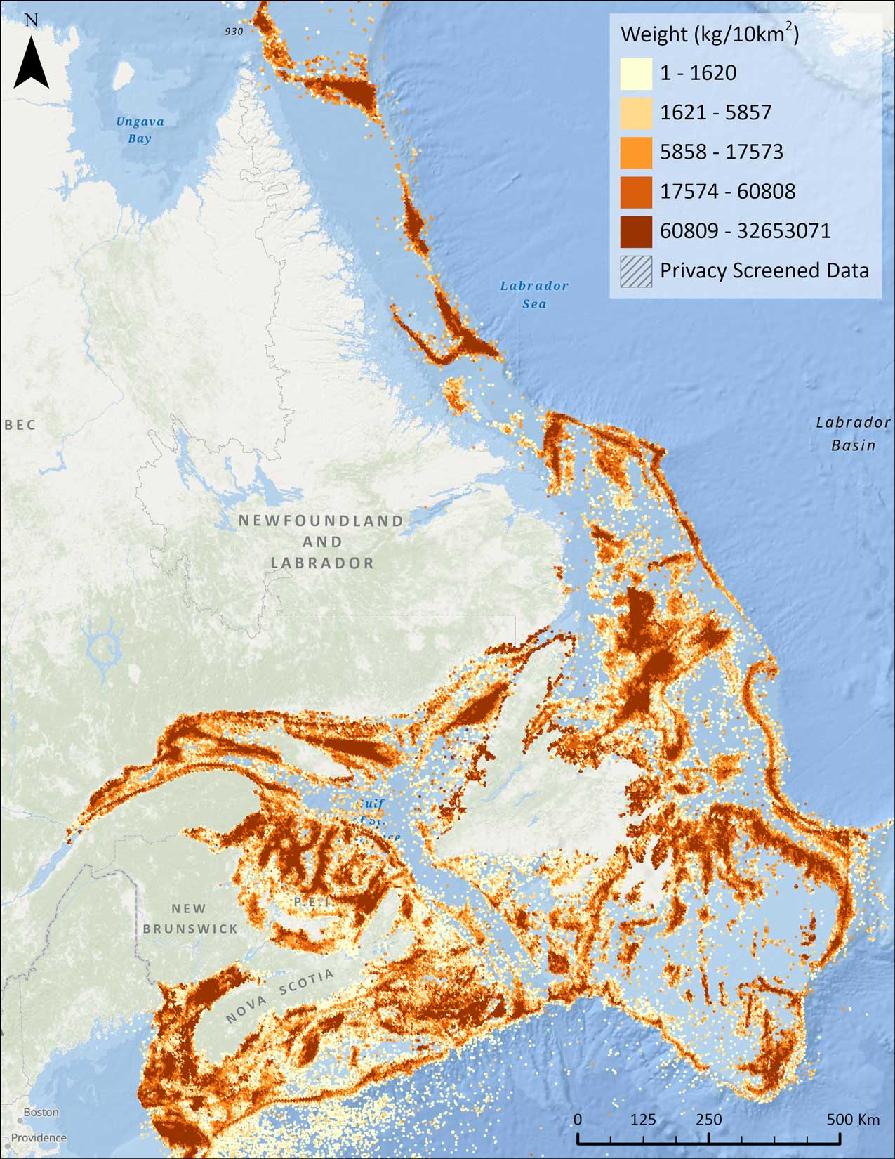
Figure 5 - Commercial Fishing Density in the NL region
Fish harvesting (Figure 5) and fish processing remain dominant employers in coastal NL despite significant restructuring of the industry since the collapse of groundfish stocks in the early 1990s. The NL fishing industry has moved from a high-volume groundfish fishery to a lower volume, but higher value shellfish fishery. The fishery continues to be a critically important industry in the region due to the high proportion of employment in rural NL:
- total employment in the fishery (both harvesting and processing) exceeded 16,000 individuals in 2022 across approximately 400 communities
- total fish landings in the NL region between 2018 and 2022 averaged over 200,000 tonnes annually, with a corresponding average landed value of over $900 million:
- shellfish (78 percent) accounted for most of the annual landed value
- groundfish (12 percent)
- pelagics (2 percent)
- other species (8 percent)
- the highest valued species accounted for over 80 percent of the total average annual landed value in the region:
- snow crab ($442 million)
- shrimp ($173 million)
- lobster ($69 million)
- Greenland halibut ($53 million)
- over the same period, an average of 3,280 active fishing enterprises reported landings at 500 ports across NL. Most of these were inshore enterprises operating vessels less than 12.2 m (40 feet) in length
- there were 6,350 individuals employed in 89 active fish processing facilities across the province in 2022
- NL exported $1.24 billion worth of fish and seafood products to more than 40 countries worldwide in 2022. These accounted for over 80 percent of the total fish and seafood export value:
- snow crab ($761 million)
- shrimp ($188 million)
- lobster ($85 million)
- the United States was the destination for 64 percent of NL's fish and seafood exports.
- Other key markets were:
- China (17 percent)
- Indonesia (3 percent)
- United Kingdom (3 percent)
- Denmark (2 percent)
Aquaculture
In 2023, aquaculture in the region (Figure 6) recorded production volume of about 19,083 tonnes and a market value of $219 million. Significant recent investment in the aquaculture industry is helping position NL as a global leader in aquaculture production. The Provincial Government is supporting an aquaculture project in the Bays West RegionFootnote 45 on the south coast of the island that is expected to create:
- 100 to 150 new local jobs
- 15,000-20,000 tonnes of additional salmon
- over $200 million in economic benefits to the province

Figure 6 - Aquaculture locations in the NL region
Energy: Petroleum and Natural Gas
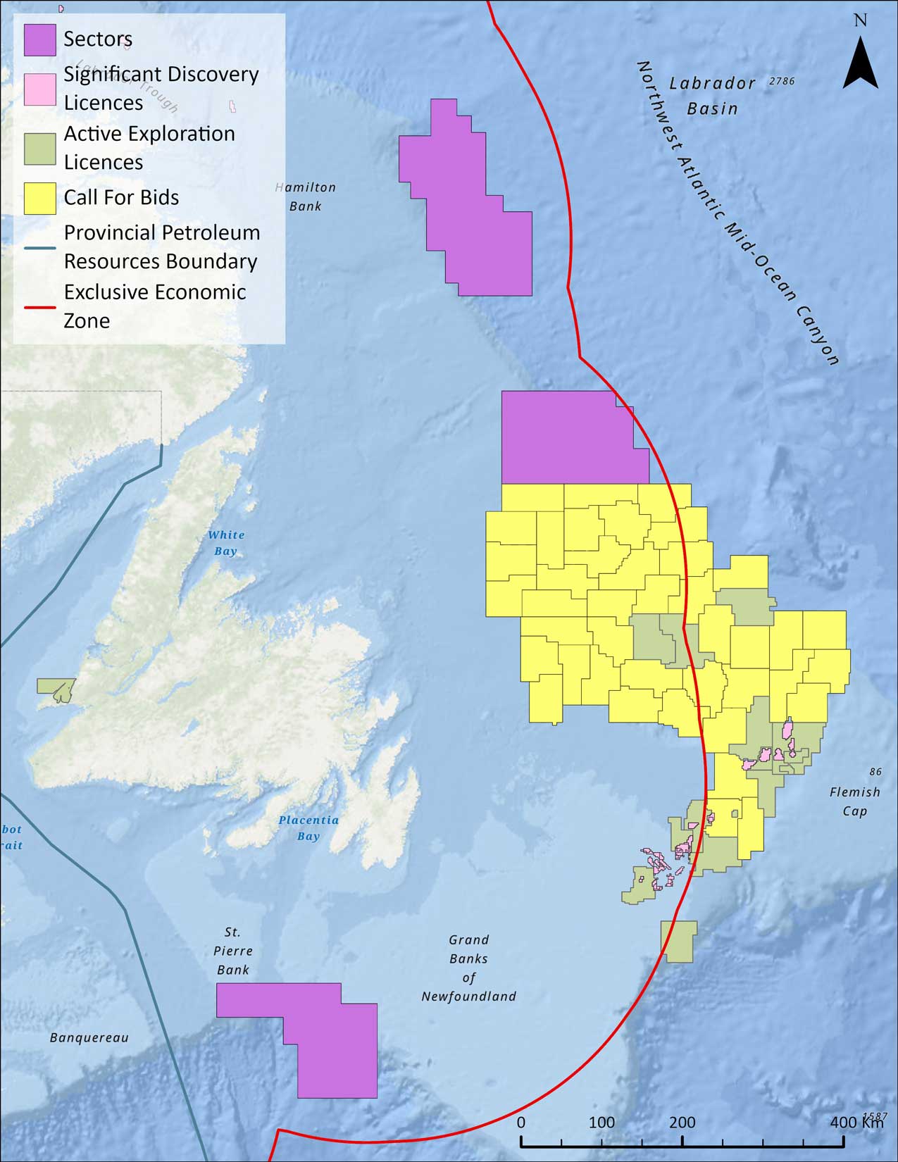
Figure 7 - Offshore oil and gas information in the NL region
The Canada-NL Offshore Petroleum Board (CNLOPB)Footnote 46 regulates the offshore oil and gas industry in the province (Figure 7). According to the Provincial Government's 2019 Advance 2030 PlanFootnote 47 to grow the NL oil and gas industry:
- 1.7 billion barrels of oil have been produced since 1997
- industry contributed to 25 percent of the provincial GDP and 41 percent of exports over the past 20 years
- approximately 5,251 people were directly employed in construction and operations on 4 offshore projects as of December 2017
- $19.8 billion in cumulative royalties was provided to the Provincial Government as of March 31, 2017
The plan outlines immediate and long-term priorities for the industry including driving exploration and sustaining production. Current offshore petroleum projects include:
- Hibernia
- Hebron
- Terra Nova
- White Rose
- Hibernia South Extension
Major energy projects in development include Bay du Nord and the expansion of White Rose.
A 2022 independent oil and gas resource assessment conducted for the Government of NL identified an additional 6.1 billion barrels of oil and 43.5 trillion cubic feet of gas potential in offshore Newfoundland. In total, there is a combined resource potential of 123.6 billion barrels of oil and 292.6 trillion cubic feet of gas in approximately 18% of the provinces offshore. Achieving the targeted growth in oil production would contribute an additional $9.8 billion to the Province's GDP by 2030, creating approximately 8,000 incremental jobs.
The Regional Assessment (RA) of Offshore Oil and Gas Exploratory Drilling East of Newfoundland and Labrador was completed in early 2020Footnote 48. The purpose of this assessment was to:
- improve the effectiveness and efficiency of the regulatory review process for exploratory drilling and associated activities in a study area
- ensure the highest standards of environmental protection were applied and maintained
In 2020, the committee responsible for conducting the RA submitted a report to the Government of Canada and Government of NL. A Ministerial response to the report and the committee recommendations outlined the importance of MSP in the region and their support of the programFootnote 49.
Marine and Coastal Tourism
In 2022, the Government of NL released Vision 2026 which outlined support for growing the tourism industry in the province through “Transition, Transform, Thrive”Footnote 50. The province has employed a successful marketing campaign over the last decade that has contributed to making tourism an economic driver for the province, particularly in rural areas.
The tourism sector in NL is a vital economic contributor with tourism expenditures consistently totaling $1 billion or more annually from 2011 to 2019. There are about 20,000 tourism-related jobs in the province, making it the second largest employment sector. Marine and coastal tourism is a particular focus with over 29,000 km of coastline and vast natural landscapes. Ecotourism and cultural tourism are a growing interest globally, both of which are linked to the province's connection to the ocean. Promoting sustainable tourism is a key element of the work of PC in:
- national parks
- national historic sites
- national marine conservation areas
Also, this tourism generates significant bonus-off economic activity (e.g. restaurants and accommodations) in rural communities.
Some of the marine activities offered by large and small operators in the province are:
- whale, seabird, and iceberg watching
- kayaking
- boating
- diving
- recreational fishing
The cruise ship industry has also been increasing in recent years, particularly at the ports of St. John's and Corner Brook.
Marine Traffic
The strategic location of NL on the Great Circle Route between eastern North America and Europe makes it important for domestic and international shipping. The Cabot Strait connects the Gulf of St. Lawrence to the Atlantic Ocean and provides a navigable passage for ships traveling to and from the St. Lawrence Seaway. The main commercial port in the region is St. John's, which saw 1,344 vessel arrivals in 2017. Marine traffic also consists of:
- ferries
- recreational boats
- offshore oil and gas industry supply vessels
Placentia Bay, on the south coast, is a major shipping route in NL, composed of, but not limited to:
- oil tankers
- container ships
- tugs
- commercial and recreational fishing boats
- interprovincial ferry
The 2 interprovincial ferry services in the region are a federal responsibility through Marine Atlantic (from NL to NS) and the international ferry service from Fortune to St. Pierre and Miquelon is provided through the Government of France. The intra-provincial ferry service, managed by the Government of NL, is an important service for the social and economic well-being of several islands and communities along NL's coast. It also has the highest number of fishing harbours in Canada with 318, of which 257 are managed by Harbour AuthoritiesFootnote 51.
In 2018, the Canadian Coast Guard re-opened the Maritime Rescue Sub-Centre in St. John's. The centre provides additional and enhanced capacity in responding to search and rescue calls in the waters surrounding NL. There are also 6 inshore rescue boat stations in the region with staff equipped to respond to marine incidents in near-shore areas.
Ocean Technology
As the global ocean economy is anticipated to double in size by 2030, NL aims to be a world leader in ocean technology. The initiatives set out by the provincial government to accomplish this are set against the backdrop of Canada's Ocean Supercluster, an industry-led collaboration built around Atlantic Canada's ocean-based companiesFootnote 52. Ocean technology growth in the province could provide an additional 3,000 jobs to the province's economy by 2030 and generate $275 million in additional GDPFootnote 53.
Energy: Transmission
Emera NL installed 2 submarine high voltage electricity cables across the Cabot Strait in 2017 to connect the electrical grids of NS and NL (Maritime Link)Footnote 54. In 2017, Newfoundland and Labrador Hydro (NL Hydro) constructed the 1,100 km Labrador-Island Link, which included a 30 km underwater cable crossing constructed across the Strait of Belle Isle to transmit power generated at Muskrat FallsFootnote 55.
Energy: Emerging Technologies
There are two 27 megawatt (MW) commercial wind projects on the island, located in St. Lawrence and Fermeuse, owned and operated by private-sector companies. There is also a research and development project in Ramea to integrate wind-hydrogen-diesel.
NL Hydro collaborated with Hatch to conduct Wind Resource Assessments (WRA) and associated analyses for 5 coastal Labrador communities:
- Nain
- Hopedale
- Makkovik
- Cartwright
- L'Anse au Loup
The initiative aimed to pinpoint areas with favorable attributes for wind energy developmentFootnote 56. The Coastal Labrador Wind Monitoring Program had 2 key objectives:
- identify suitable windy areas
- assess the feasibility of integrating wind energy with the diesel-powered electrical generators in these communities
The outcome of the Coastal Labrador Wind Monitoring Program highlighted promising potential for integrating wind turbines in 4 out of the 5 communities.
To ensure the development and use of the province's Crown land for wind energy projects in a manner that ensures the greatest long-term benefit for residents of the Province, the Department of Industry, Energy and Technology (IET) launched a Crown Land Call for Bids for Wind Energy Projects (Call for Bids) for specific Crown lands in 2022. This include:
- wind turbines
- permanent buildings
- plant facilities
- roads
- transmission lines
- hydrogen and ammonia production facilities
- surrounding Crown lands
In 2022, the Impact Assessment Agency of Canada (IAAC) started the planning phase for the Regional Assessment of Offshore Wind Development in Newfoundland and LabradorFootnote 57. The goal of the regional assessment is to help inform future project-specific impact assessments and decisions for offshore wind projects in these areas. The assessment will provide:
- information
- knowledge
- analysis related to:
- environmental
- health
- social
- economic conditions
- the potential effects of offshore wind development activities in a study area, with consideration of:
- Indigenous Knowledge
- community knowledge
- scientific information
In 2023, the Government of NL introduced a fiscal framework specifically tailored for wind-hydrogen projects in the regionFootnote 58. The framework aims to prioritize the benefits for Newfoundlanders and Labradorians and is designed to guide investment choices and resource development related to wind-hydrogen initiatives, ensuring transparency and predictability. The plan also outlines a fair distribution of financial gains, striking a balance between the interests of investors and the Provincial Government. This balance considers the utilization of the province's resources such as land, wind and water, while acknowledging the inherent risks associated with project investments.
Socio-cultural context
NL has a rich history, including Indigenous peoples' presence for thousands of years before European contact. European exploration and settlement significantly impacted the region, particularly by the British and French. The area was an independent dominion until it joined Canada in 1949. The Indigenous peoples of NL today include the Innu, Inuit, and Mi'kmaq. Their cultural heritage is deeply rooted in the region and they continue to contribute to the province's social fabric and traditions.
The population of NL is relatively small compared to other Canadian provinces. The population is diverse with a mix of cultural and ethnic backgrounds, including descendants of European settlers and Indigenous peoples. Historically, NL's economy has been heavily dependent on natural resources like fishing, mining and forestry. However, in recent years, there has been a diversification of the economy, with a focus on:
- oil and gas
- technology
- tourism
- renewable energy
The culture is deeply rooted in:
- maritime traditions
- folk music
- storytelling
- strong sense of community and hospitality
The province faces challenges related to its remote geography, harsh climate and economic sustainability. However, it offers a unique quality of life, close-knit communities and opportunities for cultural preservation and growth.
The NL Community AccountsFootnote 59 is an information system providing a reliable source of community, regional and provincial data. Understanding the socio-cultural context of NL involves appreciating its historical, demographic, economic and cultural elements, which have shaped the identity and way of life of its inhabitants. This site allows for the retrieval and mapping of statistical information on social and economic factors.
Coastal Communities
Coastal communities in NL hold immense value, encompassing:
- cultural
- economic
- environmental
- social significance
These communities are deeply intertwined with the rugged coastline and North Atlantic Ocean, shaping lifestyles, industries and heritage. Understanding and appreciating the value of coastal communities is crucial for sustainable development, conservation of natural resources and the preservation of the unique cultural fabric that characterizes this region. Balancing economic growth with environmental preservation and community well-being is key to ensuring a sustainable future for these coastal areas.
Indigenous Governments and Organizations
Indigenous Governments and Organizations in NL have a connection to the marine environment and an interest in the MSP process.
The Labrador Inuit were the first Inuit region in Canada to achieve self-government. The Labrador Inuit Land Claims Agreement (LILCA) was signed in 2005, creating the Nunatsiavut Government (NG)Footnote 60. There are approximately 7,500 beneficiaries of LILCA, with approximately 5,000 of those located in northern Labrador in:
- Nain
- Hopedale
- Postville
- Makkovik
- Rigolet
- the Upper Lake Melville Region
Imappivut is the NG's integrated and adaptive plan to manage and protect Labrador Inuit interests in the coastal and marine areas within the Labrador Inuit Land Claims Agreement. Part of this initiative involves collecting and mapping Inuit Knowledge. Additionally, the NG has an overlap agreement with the Inuit of Nunavik that allows for harvesting on a reciprocal basis. This means that Labrador Inuit may harvest in the Nunavik area, subject to Nunavik Inuit laws. Further, Nunavimmiut may harvest in Nunatsiavut subject to their laws.
There are 2 Innu First Nations in Labrador that make up the Innu Nation and they are representing 2,200 individuals:
- the Mushuau Innu First Nation is in Natuashish on the north coast
- the Sheshatshiu Innu First Nation located in Sheshatshiu in the Upper Lake Melville Region
The Innu Nation is currently in the “final agreement” phase of a land claim negotiation with Canada and the Government of NL. An Incremental Treaty Agreement (ITA) is in place for Akami-Uapishku-Kakkasuak-Mealy Mountains National Park Reserve, which includes coastal and intertidal habitat, estuaries, and numerous coastal islands. Another ITA is under negotiation for a Fisheries Resources Agreement, intended to enhance collaborative governance of fishery resources and promote economic opportunities.
The more than 6,000 members of NunatuKavut Community Council (NCC) live primarily in the 24 NCC communities in southern coastal Labrador and interior waterways. The NCC and the Government of Canada signed a Memorandum of Understanding in 2019 for its Recognition of Indigenous Rights and Self-Determination (RIRSD) process. The NCC has expressed a keen interest in science and monitoring programs, enforcement programs and the sharing of Indigenous Knowledge for marine conservation planning. The collection of Indigenous Knowledge is ongoing along the south coast of Labrador.
The Mi'kmaq of NL are represented by:
- the Qalipu First Nation (QFN) with approximately 24,000 members in 66 communities (central and western NL) with no reserve land
- the Miawpukek First Nation (MFN) located in Conne River on the south coast of NL with an on-reserve population of 836 and approximately 2,265 living off-reserve
The QFN and MFN are both represented by Mi'kmaq Alsumk Mowimsikik Kogoey Association (MAMKA) in a variety of marine and ocean stewardship matters. MAMKA participates with First Nation communities to ensure their involvement and advice in the decision-making process used for aquatic resources and oceans management including MSP. In 2017, DFO funding was used to begin compiling existing Indigenous Knowledge.
Historical, Cultural, and Archaeological Sites
Cultural and historical sites in or near the marine environment often hold significant cultural, historical, and archaeological value. Incorporating them into MSP helps preserve these sites for future generations, ensuring that important aspects of human history and culture are not lost or damaged. Many sites are sacred or hold deep meaning for Indigenous and local communities. Inclusion in MSP demonstrates respect for their heritage, traditions and rights, fostering a sense of inclusivity and collaboration.
Snapshot of sites in the NL region :
- 14 national historic sites, some of which extend to the ordinary low water mark and include estuaries and sub-tidal marine areas, promote learning more about Canadian history, including:
- diverse cultural communities
- history and culture of Indigenous peoples
- 16 heritage lighthouses designated through the recommendations of the Historic Sites and Monuments Board of Canada
- 6 UNESCO Sites, such as:
- Mistaken Point and L'Anse Aux Meadows National Historic Site
- Bonavista Bay Discovery UNESCO Global Geopark
- 7 Provincial Historic Sites with a coastal component or are adjacent to the coast, designated under the Historic Resources Act because of their historical or architectural significance
- Approximately 5,200 known archaeological sites (as of 2015) that range in age from nearly 9,000 years old to the 20th century and consist of heritage, amongst others, of:
- Inuit
- Mi'Kmaq
- Innu
- European
- Beothuk
Coastal and marine recreation
NL boasts a stunning coastal and marine environment that offers numerous recreational opportunities for locals and visitors alike, such as:
- sailing
- fishing
- kayaking
- whale watching
The coastal and marine environment offers a diverse range of recreational activities and allows individuals to appreciate the natural beauty, wildlife and cultural heritage.
The seascape holds profound cultural significance for the residents of NL. Fishing traditions, maritime heritage and coastal lifestyles are deeply embedded in their culture and identity. The seascape encompasses an extensive array of coastal landscapes, marine ecosystems, and aquatic resources and contributes significantly to the province's identity and well-being. Preserving and sustainably managing the marine environment is crucial for the prosperity and well-being of the province and its inhabitants for generations to come.
NL features a network of 32 provincial parks (some of which have coastal components) that conserve biodiversity and provide opportunities for visitors to explore nature. Provincial parks facilitate:
- camping and outdoor recreation
- scientific research and monitoring
- outdoor education
- sustainable tourism activities
The benefits of the province's provincial parks extend beyond conservation and recreation to include:
- physical and mental health
- rural employment
- tourism
- ecosystem services
- climate change mitigation
There are also 3 national parks and 1 national park reserve in NL, all of which include significant coastal areas. Parks Canada is responsible for protecting these areas and for managing them for visitors to understand, appreciate and enjoy in a way that does not compromise their ecological integrity.
Coastal and marine access encompasses both physical and interpretive means for individuals to engage in tourism, sports or other recreational activities. This involves infrastructure and facilities that facilitate awareness and understanding of the marine environment:
- land
- paths
- benches
- slipways
- marinas
- virtually
- signage
- videos
- web-based interpretation tools
Such access not only promotes community health and well-being but also contributes to economic opportunities for operators involved in marine-related activities.
Advancing MSP
Overview
Advancement of MSP processes and activities requires a collaborative approach to priority setting and data collection and use. This framework outlines an area-based approach which focuses on:
- meaningful engagement
- increasing the knowledge base
- understanding important areas
- being adaptable
Authorities will use their respective legislative abilities and authorities when advancing IOM activities and engaging in MSP processes. While the framework may guide where legislative or regulatory authorities elect to implement their respective management measures, decisions and regulatory processes remain with the respective authorities.
Moving forward
The framework outlines a coordinated approach for advancing MSP in the region with an aim to achieve the vision of ensuring a coordinated approach to promoting healthy and productive marine ecosystems that support sustainable economic, social and traditional activities to benefit current and future generations.
The framework serves as a common foundation towards IOM which establishes goals and approaches for achieving MSP objectives and priorities at a regional level. Moving forward, the expectation is that partners will continue to work together to coordinate marine planning activities throughout the region. The framework along with the atlas will help guide authorities and marine users in their management and use of shared ocean spaces.
Participation from regulatory bodies, partners and stakeholders is essential to advancing marine planning in the region. Government departments, Indigenous Governments and Organizations, and local communities and municipalities play vital roles in the understanding of area-specific challenges, ensuring the relevance of planning processes and contributing local expertise and knowledge. This collaborative effort is envisioned to help balance coastal and marine uses and emphasizes the need for conservation of marine resources and habitats while fostering social, cultural and economic benefits.
The framework supports incorporation of ecological, economic and socio-cultural priorities, and objectives into regional planning and decision-making processes and provides direction for development of specific tools, actions, KPs and mapping products.
Advancing data sharing
Utilizing and focusing efforts on continuing to share information is important for advancing IOM in the region. Through established governance structures and WGs, there is a commitment to:
- keep current priority data and information up-to-date
- develop more detailed analyses to identify and address knowledge gaps
- make data more readily accessible (e.g., through the atlas)
It is acknowledged that the atlas is not the only source of information available to decision makers; rather, it provides an important first stop for a range of spatial information in the marine space and a primary indicator of potential interactions. Other sources of data and information may be further developed as outlined in the framework. Data sharing arrangements and collaborations with external parties can help fill gaps in publicly accessible information while setting out limitations, ownership and expectations for its use.
Promoting communication and outreach
Further communication and outreach materials may be developed to educate partners, stakeholders, and the public on MSP processes, products, and approaches, including the atlas and its utility. Training and knowledge sessions have helped promote its use, increase its functionality and encourage the publication of additional marine data layers.
Incorporating climate change
Concerns about the impacts of climate change on the marine environment and infrastructure are growing, including the significant effects on various sectors like commercial fisheries and aquaculture. Mitigating the effects of and adapting to an evolving climate is a challenge for all management sectors and it is becoming increasingly important for MSP to include climate change considerations to balance human needs, protect the ocean and align with global ocean objectives. Moving forward, MSP processes can help promote climate change resilience through appropriate and meaningful engagement with partners on data sharing, knowledge sharing and best practices.
Area-based planning
Approaches outlined in the framework can contribute to IOM, including future MSP processes and activities. Smaller MSP planning areas may be identified through discussions with partners by assessing current and future uses of the marine space and identifying existing or potential conflicts between uses.
Available MSP tools and information may help guide regulatory authorities when considering new, emerging or expanding activities within planning areas. Planning scenarios may be designed around potential future uses or protection initiatives of the marine space within the area. Utilization of this information should lead to reduced negative impacts on important ecological features or existing activities and mitigation of user conflicts.
Establishing priorities
Through a review of past IOM initiatives and current government mandates and in discussions with partners and stakeholders, several broad ecological, economic and socio-cultural priorities were identified for the region under 3 strategic considerations below. Any future area-based planning process should further define and identify additional priorities under these considerations.
- Ecological considerations: focus on species, habitats, and interactions that contribute to healthy and productive marine ecosystems
- Economic considerations: focus on the sustainability of economically important industries
- Socio-cultural considerations: focus on social, cultural and ceremonial activities that contribute to human and community well-being
Guiding activities
Activities that can guide incorporation of ecological, economic and socio-cultural priorities into the management of marine spaces and further advance effective MSP implementation are outlined below.
Meaningful engagement and coordination
Engage Indigenous Governments and Organizations and other stakeholders to identify ecological priorities and foster a shared desire to protect marine ecosystems:
- to inform collective decisions that prioritize ecological issues while considering socio-cultural and economic factors
Promote collaboration and coordination among partners and stakeholders to foster a collaborative approach and partnerships:
- to coordinate economic development while considering ecological and socio-cultural priorities
Empower Indigenous Governments and Organizations and local communities through enhanced capacity, education and training:
- to increase active involvement and ensure the values, traditions, and customary practices related to marine spaces are considered and integrated effectively
Facilitate dialogue among stakeholders with varying interests to help establish socio-cultural priorities that respect different perspectives:
- to support a common understanding of priorities
Increasing the knowledge base
Facilitate the collection, mapping and availability of information for future planning to inform management and conservation of ecologically important marine habitats and species:
- to support areas of ecological importance highlighted as priorities by partners and stakeholders during initial regional MSP process discussions including:
- fish habitats, particularly nursery and spawning grounds critical for maintaining healthy fish populations and, in some cases rebuilding of commercially and/or traditionally important species
- forage species, which play a special role in aquatic ecosystems by providing substantial food for:
- fishes
- marine mammals
- reptiles
- birds
Facilitate the collection, mapping and availability of information for future planning to inform management of new and existing economic activities to streamline development of potential projects, impact assessment processes and maritime infrastructure:
- to support sustainable development of new and emerging marine industries, including site suitability:
- provide greater certainty to project proponents, regulators and management of cumulative effects
- enhance connectivity, trade and transportation efficiency, guide investments and stimulate growth
Support integration of scientific knowledge, expertise and data:
- to inform decision-making by:
- identifying ESAs
- understanding ecosystem dynamics
- predicting impacts of activities
Support the collection, mapping and incorporation of other valued knowledge sources using participatory processes from Indigenous and local ecological knowledge holders as well as industry and other sector groups:
- to help formulate appropriate management measures to protect and restore marine ecosystems and fill spatial data gaps regarding marine resource use and knowledge in management decisions
Support efforts to increase understanding of climate change impacts and incorporate climate change data in future planning:
- to better understand and prioritize climate-related work and adaptation efforts to support resilient and sustainable coastal infrastructure that can help mitigate economic risks associated with natural disasters and sea-level rise
Fill knowledge gaps that, at present, exist in the region related to the nature and distribution of social and cultural assets:
- to help:
- strengthen future cumulative impact assessments
- fuel community-level economic development
- ensure equitable outcomes from MSP initiatives
Explore methodologies to assist in the analyses of socio-cultural information:
- to help incorporate various sources and types of data, including spatial and non-spatial, qualitative and quantitative
Understanding important areas
Help identify and prioritize conservation and restoration efforts by promoting an ecosystem-based approach to management:
- to ensure the entire ecosystem and its components, including habitats, species interactions and ecosystem services are considered
Identify important ecological areas:
- to further support Canada's international commitment to protect 25 percent of its ocean area by 2025 and 30 percent by 2030, including contributing to Global Biodiversity Target #1
Identify areas where cumulative impacts may occur:
- to help reduce negative effects on ecosystems and biodiversity by strategically planning the location, timing and intensity of human activities
Identify locations of marine resources and economic activities (e.g., fishing, oil and gas, aquaculture, tourism):
- to support management decisions and help reduce or prevent conflicts
Identify areas for potential expansion of commercial activities as well as areas for new or emerging economic opportunity:
- to further support advancement of Canada's sustainable ocean economy initiatives
Identify areas of cultural significance, such as sacred sites and burial grounds, or traditional use areas:
- to allow coastal communities and Indigenous Governments and Organizations to maintain their social practices and cultural identities
Identify distribution of traditionally and culturally important species (such as American eel, Atlantic cod and salmon) including areas important to life history:
- to help in rebuilding efforts and sustainable management
Being adaptable
Promote flexibility in planning efforts through an adaptive management approach, including reviewing and updating plans and activities to accommodate evolving priorities to adjust for:
- changing ecosystems, species distribution, and stressors
- changing industry activity and geographic footprints, new technologies, and local and international stressors
- changing cultural practices, demographics, or understanding of culturally significant areas or activities
Engagement on MSP
Continued support of the framework from the various stakeholders possessing an interest in marine planning demonstrates a strong dedication to advancing IOM through ongoing collaborative efforts in line with departmental mandates, priorities and capabilities for ocean management. Engagement of government bodies in MSP processes can occur through established governance structures. Where appropriate, partners can demonstrate their commitment to the framework by promoting and integrating MSP processes and products into their policies, programs and planning activities.
While the framework is not legally binding, departments and agencies represented on ROCOM can assist in advancing the outlined approaches to MSP in the region by exercising their regulatory and/or legislative instruments. Where appropriate, ROCOM members can:
- consider MSP priorities in decision-making and policy development as it relates to use of marine space
- utilize MSP knowledge products and decision support tools (particularly the atlas) to inform decision-making and policy development as it relates to use of marine space
- continue to participate in IOM discussions through ROCOM and CNLCOM including identification of policy and program linkages with MSP
The Indigenous Government and Organizations within the region had input throughout the development of the framework and have indicated a willingness to continue to support all subsequent IOM activities and MSP processes, particularly in relation to supporting Indigenous initiatives, such as the NG's Imappivut.
The MSP governance model emphasizes involving various stakeholders who are responsible for or interested in coastal and ocean management in the planning process. Mechanisms outlined in the framework can be utilized and new ones identified as required to support opportunities for stakeholder participation and engagement. As their capacity allows, participants can identify and incorporate information needed to advance IOM.
Conclusion
Newfoundland and Labrador's ocean area is continuing to get busier, creating a need for managing the ocean in a more coordinated way through IOM. MSP plays a vital role in achieving IOM by bringing people together to plan for sustainable ocean use, protection and governance in line with Canada's commitments while respecting Indigenous rights and reconciliation.
MSP in Canada is a flexible process that helps plan and manage how the ocean is used for various activities. It creates processes, products and plans for different parts of the ocean, evaluated regularly and changed based on what is happening in the ocean and what people need. This type of planning is not a one-time activity; it is an ongoing, evolving and iterative process that changes as more knowledge is gained and needs evolve. Working together with partners and stakeholders through a shared vision and planning goals is crucial to the success of MSP. Additional regional principles and goals may also be established with partners and stakeholders if needed. The framework provides a guide for the future advancement of IOM activities that may focus on specific or localized areas and issues.
Ultimately, properly implemented MSP can:
- lead to the enhancement of productivity and ecological resilience of the marine environment by promoting a balanced and sustainable coexistence of human activities with marine ecosystems
- support the growth of key economic sectors while preserving the health and integrity of marine ecosystems by systematically planning and organizing marine activities
- help ensure sustainable and equitable use of marine resources by respecting the diverse needs and values of people and communities
Appendix A - Relevant acts
This appendix contains overviews of select federal and provincial laws. It is not intended to be a comprehensive list of all legislation and regulations that relate to the management of ocean resources or activities. Instead, it concentrates on the statutes most closely associated with the topics addressed in the framework. For more in-depth information, refer to the links provided where relevant government departments and agencies present more detail from which these summaries are derived.
The Oceans Act promotes sustainable and integrated management of Canada's oceans ensuring that they remain healthy and productive for current and future generations. The Act establishes Canada's maritime zones, including:
- fishing zones and territorial sea coordinates
- the establishment, designation and enforcement of MPAs, and networks of conserved areas
- the development and implementation of plans for the integrated management of:
- all activities or measures in or affecting estuaries, coastal and marine waters that form part of Canada or in which Canada has sovereign rights under international law
- activities necessary to foster understanding, management and sustainable development of oceans and marine resources
- the provision of Coast Guard and hydrographic services to ensure the facilitation of marine trade, commerce and safety
The Fisheries Act provides:
- protection for all fish and fish habitat
- promotes restoration of degraded habitat and rebuilding of fish stocks
- provides tools to strengthen marine refuges to ensure the long-term protection of biodiversity
- includes modern safeguards ensuring the Act provides strong and meaningful protection for Canada's fish and waters
The Fisheries Act applies in Canada or within Canadian fisheries waters and to sedentary species in any portion of Canada's continental shelf.
Aquaculture Act - RSNL1990 chapter A-13
The purpose of the Aquaculture Act is to:
- allow for orderly and sustainable development of aquaculture
- secure property rights
- minimize conflicts
- ensure cooperation between the Government of Newfoundland and Labrador and Government of Canada
The Act applies to finfish, shellfish and aquatic plants.
The purpose of the Species at Risk Act is to:
- prevent wildlife species in Canada from disappearing
- provide for the recovery of wildlife species that no longer exist in the wild in Canada, are endangered or are threatened as a result of human activity
- manage species of special concern to prevent them from becoming endangered or threatened
A public registry contains documents related to the administration of the Act including listed species and measures to protect them. Critical habitat is defined as the habitat that is necessary for the survival or recovery of a listed wildlife species and that is identified as the species' critical habitat in the recovery strategy or in an action plan for the species. Critical habitat has been identified for several species in the region including Northern wolffish and spotted wolffish.
Fishing and Recreational Harbours Act
The Fishing and Recreational Harbour Act gives authority to:
- regulate the use
- management
- maintenance of recreational fishing or fishing harbours
Many harbours are operated and managed by independent Harbour Authorities that represent local communities.
The Canada Marine Act governs a broad range of activities designed to make Canada's ports competitive, efficient and commercially oriented. Major ports and terminals are under the authority of Transport Canada.
Migratory Birds Convention Act, 1994
Canada seasonally hosts approximately 450 species of native birds, the majority of which are protected under the Migratory Birds Convention Act and are collectively referred to as migratory birds. It is the responsibility of ECCC to develop and implement policies and regulations to ensure the protection of migratory birds, their eggs and their nests. The Act provides for the protection of migratory birds through:
- the Migratory Birds Regulations
- the Migratory Birds Sanctuary Regulations
The hunting of migrating game birds is managed through bi-annual process of consultation resulting in the amendments of the Migratory Game Bird Hunting Regulations and established according to national objectives and guidelines.
Migratory Bird Sanctuary Regulations
The Canadian Wildlife Service of ECCC is the agency responsible for Migratory Bird Sanctuaries (MBS), which can be located on federal, provincial or private land. These sanctuaries are comprised of migratory bird habitat that provides safe refuge for migratory birds in the terrestrial and marine environment. MBS are listed under the Schedule in the Regulations, which prescribe rules and prohibitions. Marine components of these sanctuaries can be counted as MPAs.
The Canada Wildlife Act allows for the:
- creation
- management
- protection of wildlife areas for wildlife research activities or for
- conservation or interpretation of wildlife
The purpose of wildlife areas is to preserve habitats that are critical to migratory birds and other wildlife species, particularly those that are at risk. The Wildlife Area Regulations prohibits all activities that could be harmful to species and to their habitat unless a permit is issued for the indicated activity. Activities such as hiking, canoeing, photography and bird watching can be carried out without a permit in most areas.
Canada National Marine Conservation Areas Act
The Canada National Marine Conservation Areas Act is administered by Parks Canada. NMCAs are established and managed to protect and conserve representative marine areas for the benefit, education, and enjoyment of the people of Canada and the world. They include submerged lands and the water above them as well as any species present. They can also take in wetlands, estuaries, islands, and other coastal lands.
The Canada National Park Act applies to national park reserves and provides the same protections as those of national parks. Parks Canada is responsible for protecting these areas and for managing them for visitors to understand, appreciate and enjoy in a way that does not compromise their ecological integrity. National parks represent Canada's terrestrial national regions which can also include intertidal and subtidal marine components. National park reserves are managed like national parks but are subject to one or more Indigenous land claims. These land claims are being negotiated between the federal government and Indigenous Governments. Indigenous peoples continue to use the land for traditional hunting, fishing and trapping.
The Canada Shipping Act promotes:
- efficiency and safety in marine transportation
- encourages the safe, effective and economical use of Canadian waters by recreational boaters
- protects the marine environment from damage due to navigation and shipping activities
- prevents pollution from vessels
Canada–Newfoundland and Labrador Atlantic Accord Implementation Act and RSNL1990 Chapter C-2 – Canada-Newfoundland and Labrador Atlantic accord implementation Newfoundland and Labrador Act
The Canada-Newfoundland and Labrador Atlantic Accord Implementation Act promotes safety and the protection of the environment in respect to exploration and exploitation of petroleum. It:
- describes the area covered by the Act
- establishes the Canada-NL Offshore Petroleum Board as the governing authority
- sets the terms for issuing of interests, exploration, production, administration and other activities part of petroleum operations in the Accord area
Wilderness and Ecological Reserves Act – RSNL1990 Chapter W-9
The Wilderness and Ecological Reserves Act allows for the designation of provincial ecological reserves to preserve and protect species and ecosystems and allow for scientific research and education.
Labrador Inuit Land Claims Agreement Act and SNL2004 CHAPTER L-3.1 - LABRADOR INUIT LAND CLAIMS AGREEMENT ACT
The Labrador Inuit Land Claims Agreement Act outlines the agreement between federal and provincial governments and the Labrador Inuit people regarding their land rights and self-governance. The Agreement is a modern-day treaty between the Inuit of Labrador and the Governments of NL and Canada and is constitutionally protected under section 35 of the Constitution Act, 1982.
Page details
- Date modified: