
SG̲áan K̲ínghlas-Bowie Seamount Gin siigee tl’a damaan kinggangs gin k’aalaagangs Marine Protected Area Management Plan 2019
Table of Contents
- Complete Text
- Foreword
- Acknowledgements
- Disclaimer
- About the SK̲-B Logo
- Haida Language
- Executive Summary
- 1 Introduction
- 2 Cooperative Governance
- 3 SK̲-B Guiding Principles
- 4 Conservation Significance and Human Use
- 5 Management Framework
- 6 Surveillance, Enforcement and Compliance
- 7 Education and Outreach
- 8 Implementation
- Glossary
- References
- Acronyms for Frequently Used Terms
- Appendix 1: Bowie Seamount MPA Regulations
- Contact information
List of Boxes
- Box 1. SK̲-B MPA History Highlights
- Box 2. Other Cooperative Processes
- Box 3. A Recent History of Socio-Economic Activities in the SK̲-B MPA
- Box 4. Regional Vessel Traffic Context
- Box 5. Developing Goals and Objectives
- Box 6. SG̲áan K̲ínghlas aauu tl’a ‘waadluwaan hlGajagang (We all take care of SG̲áan K̲ínghlas)
List of Figures
- Figure 1. SG̲áan K̲ínghlas - Bowie Seamount Marine Protected Area Map
- Figure 2. Haida Eddies in the vicinity of the SK̲-B MPA
- Figure 3. SK̲-B MPA Management Framework
List of Tables
- Table 1. Linkages between SK̲-B MPA guiding principles, Canada’s MPA and oceans strategies and frameworks and EBM principles
- Table 2. SK̲-B MPA Management Priorities and Associated Actions
1 Introduction
The SG̲áan K̲ínghlas (SAH-aawn KING-thlus)–Bowie Seamount is one of the shallowest seamounts in the North Pacific, rising from a depth of 3,000 metres to within 24 metres of the ocean’s surface. The seamount is an underwater mountain formed by volcanic activity which fosters unique oceanographic interactions that enhance the biological productivity of the area. Eddies enrich and trap nutrients around the seamount to support a highly biodiverse ecosystem that acts as a refugium and nursery for flora and fauna, and provides an important feeding area for resident and migratory fish species, transient marine mammals, and seabirds.
The Haida have a historical, spiritual and cultural connection with the SG̲áan K̲ínghlas-Bowie Seamount area. According to Xaads gin k’iiygangaas (Haida oral traditions), before the time of humans, supernatural beings made their home beneath numerous places around Haida Gwaii including mountains, creeks, shoals and reefs and, in this case, the site of an ancient volcano. The seamount is said to be the home of a supernatural being known as SG̲áan K̲ínghlas, which in the Masset dialect means “supernatural being looking outwards.”
SG̲áan K̲ínghlas and the surrounding area have been designated by both the Haida Nation and Canada as a protected area (Box 1). The Haida Constitution holds the living Haida generation responsible for ensuring that natural and cultural heritage is passed on to following generations, and in 1997 the Council of the Haida Nation (CHN) designated SG̲áan K̲ínghlas as a Xaads siigee tl’a damaan tl’a king giigangs (Haida marine protected area). In 1998, the Minister of Fisheries and Oceans identified Bowie Seamount as an Area of Interest (AOI), and in 2008 the area was designated as a Marine Protected Area (MPA) under Canada’s Oceans Act by way of the Bowie Seamount Marine Protected Area Regulations (the SK̲-B Regulations, Appendix 1). Respecting the collaborative approach to the area’s planning and management, it is commonly referred to as the SG̲áan K̲ínghlas-Bowie Seamount (SK̲-B) MPA.
The purpose of the MPA is to conserve and protect the unique biodiversity and biological productivity of the area’s marine ecosystem, which includes the SG̲áan K̲ínghlas-Bowie, Hodgkins and Davidson seamounts and the surrounding waters, seabed and subsoil. This Management Plan (the Plan) identifies goals, strategic objectives, and operational objectives for the MPA to support this purpose and describes how they will be achieved. It was prepared by the SK̲-B Management Board in consultation with the SK̲-B Advisory Committee.
Box 1. SK̲-B MPA History Highlights
- 1997
- CHN designates SG̲áan K̲ínghlas a Xaads siigee tl’a damaan tl’a king giigangs (Haida marine protected area).
- 1998
- DFO announces the Bowie Seamount complex as an AOI for consideration as an MPA under the Oceans Act.
- 2001–2007
- Pre-Oceans Act MPA designation Advisory Team assesses the AOI and recommends designation as an Oceans Act MPA.
- 2007
- The Haida Nation and Canada sign a Memorandum of Understanding that commits to facilitate the cooperative planning and management of the area through the establishment of a Management Board.
- 2008
- On April 17, the area is designated Canada’s seventh MPA under the Oceans Act.
- 2011
- The SK̲-B Advisory Committee is established.
- 2018
- The SK̲-B Management Plan is completed.
1.1 Location
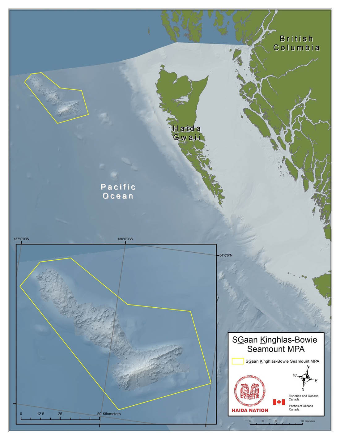
Figure 1. SG̲áan K̲ínghlas-Bowie Seamount Marine Protected Area Map
The SG̲áan K̲ínghlas-Bowie (SK̲-B) Seamount is located 180 km offshore of Xaayda gwaay (Haida Gwaii), situated off the North Pacific coast (Figure 1). The boundaries of the SK̲-B MPA include the SG̲áan K̲ínghlas-Bowie, Hodgkins, and Davidson seamounts and their surrounding waters, seabed, and subsoil. The total area of the SK̲-B MPA is 6,131 km².
1.2 Prohibited Activities and Exceptions
The SK̲-B Regulations (Appendix 1) prohibit activities that disturb, damage, destroy, or remove from the area any living marine organism or any part of its habitat, or the seabed. Similarly, any activity that deposits, discharges or dumps substances that are likely to result in the disturbance, damage, destruction or removal of living marine organisms or any part of their habitat is also prohibited.
Under the SK̲-B Regulations, certain activities may be carried out within the MPA (called “exceptions” in the SK̲-B Regulations) under specified conditions. These activities include, among others, Aboriginal, commercial and recreational fishing; vessel travel; and marine scientific research. This Management Plan provides guidance on activities that may be carried out in the MPA, including the conservation and management objectives for the MPA outlined in Section 5.
- Date modified: