
Center of Expertise in Marine Mammology: Scientific Research Report 2012-2014
Table of Contents
- Acknowledgements
- Message from the Director of CEMAM
- The 2013 High Arctic Cetacean Survey
- St. Lawrence Estuary Beluga
- Predator-borne Acoustic Transceivers and GPS Tracking Reveal Encounters with Acoustically Tagged Free-ranging Marine Fish
- Long-term Measures of Reproductive Performance Reveal Marked Variation in Fitness in Grey Seals
- Year-round Atlas of Shipping Noise: The PSSEL Model
- Climate Related Changes in the Quality and Availability of Land Fast Sea Ice Suitable for Breeding Ringed Seals Along the Coast of Labrador
- Belugas and Ringed Seals: Indicators of Ecosystem Change in the Beaufort Sea
- The Impact of Climate Change on Reproduction in an Ice-dependent Species, the Northwest Atlantic Harp Seal
- Publications 2012-2014
Climate Related Changes in the Quality and Availability of Land Fast Sea Ice Suitable for Breeding Ringed Seals Along the Coast of Labrador
Becky Sjare
Ringed seals are a key species in seasonally ice-covered Arctic marine ecosystems because they link the aquatic food web to higher level predators such as polar bears, arctic fox and ravens. In addition, they are an important country food for Inuit in northern communities and are also of cultural significance. Ringed seal pups are born in a snow cave (lair) constructed by the female near a well-drifted pressure ridge or ice hummock of rough ice. The lair provides much needed shelter from the cold temperatures as well as helps protects the pup from predation. Adequate snow cover and appropriate ice roughness have been correlated with increased survival of ringed seal pups. Ice that is too smooth does not allow adequate snow drift development for the proper construction of the lair and extremely rough ice is often too thick and potentially to too mobile for the females to effectively maintain the lair and ensure the pup is not crushed by the ice.
A GIS-based model that uses RADARSAT satellite imagery (24m resolution; Figures 12 and 13) of land fast ice has been developed to quantify changes in the availability of quality ringed seal pupping habitat along the coast of Labrador. Three core study sites were located in the vicinity of Nain, Hopedale and Rigolet (2001-2013) and four in more northern fjord areas (Nachvak, Saglek, Hebron and Okak; 2008-2013). Most recently, exploratory research is ongoing at sites near the Belcher Islands and in the eastern James Bay region of Hudson Bay (2012-2013). The key land fast ice parameters used by the model to identify quality habitat included the presence, concentration and distribution of rough ice. Although various analyses are ongoing, for areas of the coast that generally have the highest availability of quality pupping habitat, it is apparent that in some years pack ice surges very close to shore compressing favorable rough ice habitat into a narrow band. In other years when wind forcing on the pack ice is minimal, freezing occurs quickly and a near solid sheet of smooth ice extends right out to the edge of the pack ice – again minimizing the availability of useable rough ice. There is evidence of these two unfavorable types of scenarios occurring in 2001, 2002 and 2004-06 and 2010.
This research will provide a comprehensive geographic perspective of changing land fast ice for coastal Labrador as well as a comparative glimpse at sites in eastern Hudson Bay. In the future, it may allow researchers to quantitatively link the reproductive productivity of seals to changing habitat availability and/or quality. These new data will also provide the opportunity to both identify areas of land fast ice that may be especially vulnerable to climate related changes along the coast of Labrador and to better understand what this may mean for successful ringed seal production in the future. The USA has recently listed the Arctic sub-population of ringed seals as threatened under their Endangered Species Act based on medium and longer term projections of sea ice deterioration in Arctic regions. This development emphasizes the importance of understanding and predicting the relationship between changing sea ice habitat and ringed seal productivity in Canada’s northern waters.
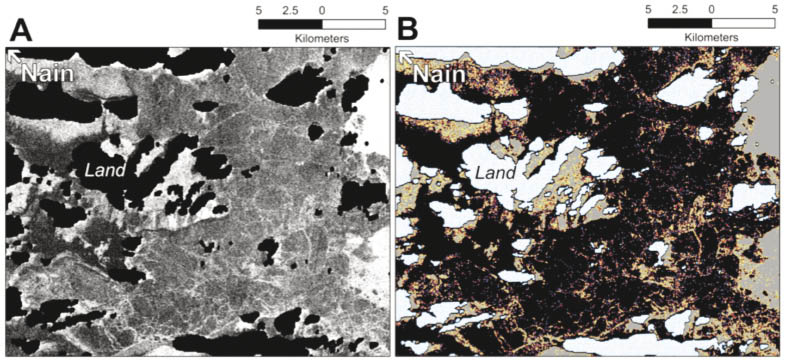
Figure 12.
(A) A near raw RADARSAT-1 image of the Nain, Labrador study area recorded on 18 March 2003. In this image land masses are intense black and the heavy pack ice along the eastern edge of the frame is bright white. Dark to intermediate grey areas identify relatively smooth ice while the brighter white spots and bright linear structures highlight moderately rough ice including ice hummocks and pressure ridges. To produce the habitat suitability map (B), a neighbourhood focal statistic (ArcGIS 2010) was used to calculate the amount of rough ice around individual pixels in the image. In this image the color legend is as follows: white with blue speckle = land; black = smooth ice (generally unsuitable habitat); blue = light rough ice (useable); red = moderate rough ice (prime pupping habitat); yellow = heavy rough ice (useable); grey = rubble or pack ice (generally unsuitable). Ice conditions were favorable for ringed seals in the Nain area in 2003 (one of the better years in the time series) with 30% of the habitat being classified as prime or useable and 48% and 22% being too smooth or rough respectively. Images are displayed north-up.
Color legend: white with blue speckle=land; black = smooth ice (generally unsuitable habitat); blue = light rough ice (useable); red = moderate rough ice (prime pupping habitat); yellow = heavy (useable); grey = rubble or pack ice (generally unsuitable).
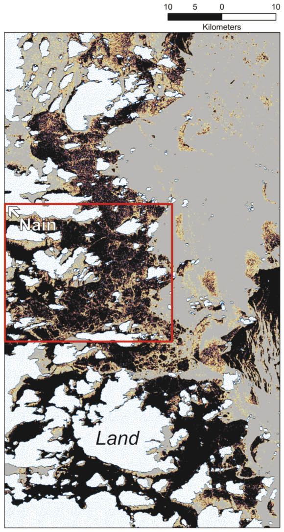
Figure 13.
Results of a habitat suitability map of ringed seal pupping habitat covering a larger geographic area (~ 3400 km2). The area inside the red box represents the core area shown in Figure 12A & B. The good correspondence between key ice features in each of the two images indicates that the current version of the model can be successfully scaled to a larger geographic area. The red arrows identify examples of important pressure ridges that characterize prime pupping habitat.
Color legend: white with blue speckle=land; black = smooth ice (generally unsuitable habitat); blue = light rough ice (useable); red = moderate rough ice (prime pupping habitat); yellow = heavy (useable); grey = rubble or pack ice (generally unsuitable).
- Date modified: